Custom Maps for Gaia GPS

1Louder

Explorer
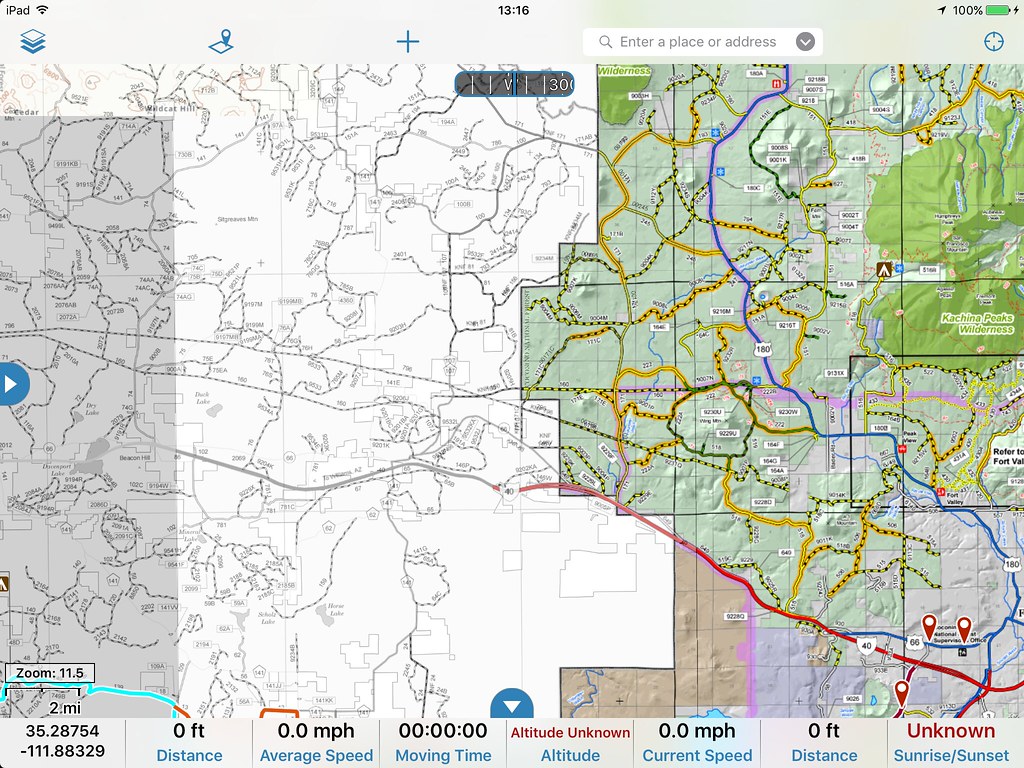
Not sure how many of you are aware of this feature but you can import custom maps into Gaia GPS via a tool they provide. I wrote a basic tutorial on how to do this using Google Maps as the example. This is a very powerful tool. One that I am trying to take to the next level by importing all of the Motor Vehicle Use Maps beginning with Arizona. These are fast becoming the only Official record of open forest roads. If you want to stay legal you need to reference these maps. While PDF Maps for iOS allows you to use the maps already Gaia GPS is my preferred navigation app. I don't like to bounce back and forth between apps if I don't have to.

Here's an example of 2 custom maps layers. On the left is the Kaibab National Forest Williams District Map in black and white and the Coconino National Forest North map in color.
29344649693_43ff115afe_b.jpg


To get all of this to work and to get the highest resolution of maps available it will take purchasing some software which is not cheap. The other hope is Gaia will just eventually incorporate these layers into their app directly. Most likely these would only be available with a pro subscription.

So for those of you who use Gaia how valuable would these map layers be to you?
[ ] Only if they are free
[ ] Only if they are free from within Gaia GPS
[ ] Yes, I would pay $5-10 for the ability to access these maps from a 3rd party
[ ] Yes, I would be willing to pay for an annual pro subscription from Gaia

I don't work for Gaia. I am just a heavy user, product evangelist, and I am always trying to make the app even better.

My tutorial to learn how to import custom maps can be found here: http://www.4xoverlandadventures.com/import-custom-maps-gaia-gps/

Thanks,
Chris

Here is the current complete list of MVUM maps across the country.
http://www.fs.fed.us/recreation/programs/ohv/ohv_maps.shtml


They have just added Hunting Map layers and public lands identification overlays to the pro subscriptions. http://blog.gaiagps.com/
 
Last edited:

MountainBiker

Experience Seeker
So for those of you who use Gaia how valuable would these map layers be to you?
[ ] Only if they are free
[ ] Only if they are free from within Gaia GPS
[ x ] Yes, I would pay $5-10 for the ability to access these maps from a 3rd party
[ maybe ] Yes, I would be willing to pay for an annual pro subscription from Gaia

Here is the current complete list of MVUM maps across the country.
http://www.fs.fed.us/recreation/programs/ohv/ohv_maps.shtml
I can see paying for accessing those map layers, but I need to spend some time with Gaia as it is, since I just purchased the app.

I've been using the MVUM's on PDFMAPs (Android), and they work fairly well. What I don't like is that it just shows one map at a time. When you are near the edge of the map, you can't see the road options that are on the adjacent map, which is frustrating. Too bad there isn't a master map of the complete National Forest that is all one file. This still wouldn't address the issue of when you are near BLM or other land, which isn't shown on the MVUM.
 

1Louder

Explorer
I can see paying for accessing those map layers, but I need to spend some time with Gaia as it is, since I just purchased the app.

I've been using the MVUM's on PDFMAPs (Android), and they work fairly well. What I don't like is that it just shows one map at a time. When you are near the edge of the map, you can't see the road options that are on the adjacent map, which is frustrating. Too bad there isn't a master map of the complete National Forest that is all one file. This still wouldn't address the issue of when you are near BLM or other land, which isn't shown on the MVUM.

Yep you will be able to do that in Gaia which is nice. I have 3 adjacent MVUMs in AZ all next to each other with no issues. You need a Pro subscription though to allow for layers. You can get one year for free if you check out this article. Info is at the bottom.

http://www.4xoverlandadventures.com/navigation-app-choice-gaia-gps/
 

jCubed

Adventurer
Rad! How do you do it??? I'm still pretty confused on the conversation.


Sent from my iPhone using Tapatalk
 

1Louder

Explorer
Rad! How do you do it??? I'm still pretty confused on the conversation.

The map you provided is not Geo-referenced so it will not work. Do you have the web address of all of the individual maps? Maybe they are.

The way it works is the PDF's have lat/long coordinates associated with them. Then you can use an application like MapTiler to convert the PDF to usable data. The data is then uploaded to a web server where they can be referenced by apps like Gaia GPS.

This is the electronic data that I would like to source: http://usfs.maps.arcgis.com/home/webmap/viewer.html?services=18de7e3f022a432f850c864ad4ba952d
but I haven't figured out how to do that yet. Note that I think the Hood area is not included. This likely means the PDF's while legal and current are really out of date for that area and hopefully are being updated.
 

jCubed

Adventurer
I've gotcha! Well hopefully that changes. Thanks for trying! I really do love GaiaGPS. It's such a solid system.


Sent from my iPhone using Tapatalk
 

sjbendy

New member
I just came on this thread via a web search. I also prefer Gaia, but ride in the national forests where a MVUM map is a must - forcing me to use Avenza PDF maps. I will be watching this thread and reading it in more detail.

We ride in the Black Hills (South Dakota), Wagon Wheel trails (near Meeker, Colorado), and the Big Horn Mountains (Wyoming).
 

malibubts

Adventurer
I just came on this thread via a web search. I also prefer Gaia, but ride in the national forests where a MVUM map is a must - forcing me to use Avenza PDF maps. I will be watching this thread and reading it in more detail.

We ride in the Black Hills (South Dakota), Wagon Wheel trails (near Meeker, Colorado), and the Big Horn Mountains (Wyoming).

I was initially looking for a way to import the MVUM as well, but after playing around with Gaia I was able to find one of the map layer options is "USFS Raster". After looking at this and comparing the layer to the MVUM I think they have already done the hard work for us and imported it and geo-referenced it. Anyone correct me if I am wrong, but I see all of the Forest Roads called out identically to the MVUM.
 

1Louder

Explorer
I was initially looking for a way to import the MVUM as well, but after playing around with Gaia I was able to find one of the map layer options is "USFS Raster". After looking at this and comparing the layer to the MVUM I think they have already done the hard work for us and imported it and geo-referenced it. Anyone correct me if I am wrong, but I see all of the Forest Roads called out identically to the MVUM.

I don't know if that is true but I can do an overlay of the Coconino forest to see. I will post up the results when I can.
 

flashkiwi

New member
I was initially looking for a way to import the MVUM as well, but after playing around with Gaia I was able to find one of the map layer options is "USFS Raster". After looking at this and comparing the layer to the MVUM I think they have already done the hard work for us and imported it and geo-referenced it. Anyone correct me if I am wrong, but I see all of the Forest Roads called out identically to the MVUM.

Generally they should be identical, but not in all cases. The MVUM is the authoritative source for USFS vehicle/ATV access, and generally (but not always) up-to-date (And not all Forests have completed a MVUM). The USFS Raster is is based on the USGS 24k with USFS overlays. Not all roads or trails represented on the USFS Raster are actually legal to traverse - you need to refer to the MVUM for that. The ideal scenario would be the USFS Raster with a MVUM Vector overlay.....
 

Forum statistics

Threads
185,783
Messages
2,878,185
Members
225,329
Latest member
FranklinDufresne
Top