wheeling in the san juans, june 8-9, 2006

photoleif

Observer
for you on YT, i've posted this there as well, but i thought this wouldn't be a bad first post here.

i took my wife wheeling in the san juans last week. it was nice despite my rapidly deteriorating IFS. here are pix and some comments.

kennebec01.jpg

truggy near kennebec pass. this is a parking lot with nice views. the pass is to the east and is still snowed in. i made the mistake of driving out on the shelf road, only to have to back up a few hundred yards with a big dropoff on the side.

kennebec02.jpg

a view from just west of the parking lot. it's not really a parking lot per se, but it's big and flat and dirt. sounds like a parking lot enough for me. the colorado trail crosses this area, and a scary-looking spur continues east through the pass, which is blasted through a high ridgeline.


kennebec04.jpg

another shot from the top, looking west to hesperus peak and sharkstooth.


lime01.jpg

the next day, we did a warmup on a passenger-car accessible road north of durango. the road isn't anything spectacular in early summer, but the flowers are nice.


corkscrew01.jpg

here's where the real fun started: corkscrew pass. that's a view to the southeast from near the summit. it was as chilly as it looks: 41° and a stiff wind that rocked the truck.


corkscrew03.jpg

a view from the top, at around 12,200'.


corkscrew05.jpg

oh, back at the top...haha. "ok, i won't drive my truck in the pond."


corkscrew06.jpg

here's an angle typical of the sections near the summit. i don't have an inclinometer, but i'd guess it's in the 20° range in spots.


corkscrew07.jpg

i'd call that a room with a view! (in case it's too small to see, the outhouse door is completely off the hinges.)


meve01.jpg

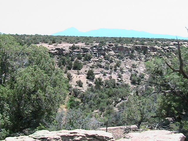
and finally, back to mesa verde. my wife had to work the next day so i tagged along on one of her tours.
 

goodtimes

Expedition Poseur
The San Juans are such a awesome range. Absolutely stunning. My first backpacking trip after I got out of the military was in the San Juan Wilderness Area. Despite the torrential downpour, being out of shape (unless you consider "round" to be a shape), a pack that didn't fit very well, and being unprepared for the rain......it was a spectacular trip. We started just outside of Platoro, hiked up Middle Fork to the Continental divide, hung a left and followed the CDT over to Blue lake, and then back to the truck. I still want to get back in there and finish the trip (we were forced to leave before we made the loop down to green lake to the south). The San Juans should be on everyones list of places to visit. Simply awesome!
 

photoleif

Observer
calamaridog said:
That second picture just got added to my wallpaper file for my work computer:wavey:

Thanks for sharing!
not a problem. if anyone wants larger versions of any of these, please feel free to PM me. these are my snapshots, and i'll give freely of them.
 

Willman

Active member
??????

photoleif,
Question.......Where are the san juans???????? I'm not good with the GPS cord. thing......Where are you from???

:confused:

by the way......great pics!!!!! Looks like you had fun!!!
 
Last edited:
S

Scenic WonderRunner

Guest
Willman said:
photoleif,
Question.......Where are the san juans???????? I'm not good with the GPS cord. thing......Where are you from???

:confused:

by the way......great pics!!!!! Looks like you had fun!!!


This probably explains the area pretty well!

Kennebec Pass

.
.
 
S

Scenic WonderRunner

Guest
Photolief...................

I just now found your website!

Very Nice!

....and welcome to ExPo.........!
 

photoleif

Observer
yep, that is indeed the place. i used the term 'san juans' loosely to describe the set of destinations on that trip, but to be a bit more precise, kennebec pass is near the san juan mountains, and is actually in the la plata mountains. to further confuse the matter, the la platas are in the san juan nat'l forest.

corkscrew pass *is* in the san juan mountains. many of the mountains down there are geologically related, in that volcanism is responsible for the upheaval of later rocks that subsequently resulted in the erosion we now credit with forming these mountains. the la platas are an interesting jumble of older and newer rocks, some volcanic and squeezed up among newer sedimentary rocks, and others formed by laccoliths, meaning a volcano tried and failed to erupt there, and instead just raised the sedimentary rock, which continues to erode. for instance, on the final pass road, you can find fossils in rocks right next to metamorphic rocks, which bear no fossils and are of a completely different origin. elsewhere in the area, for instance near south fork, you can see pyroclastic bombs in meadows. the rich volcanic soil and frequent slides contribute greatly toward the aspen that blanket the area.

the nearby sleeping ute mountain is a great example of another laccolith with exposed volcanic plugs now known as 'the toes'. shiprock is another volcanic plug nearby revered by prehistoric and modern ute peoples.
 
S

Scenic WonderRunner

Guest
Compelling info Photolief!!!!!!!!

Sounds awesome!

I'm also interested in the Weminuche Wilderness area.

I borrowed this sat. map of the area from Darrens website.

:cool: I think you and Darren should consider Hosting the First Annual ExPo. Expedition to the San Juans THIS SUMMER!..........:ylsmoke:

Please put me down for 1st on the list!:wavey:

Hurry up!.....get Cracking!......chop chop!.............:elkgrin:


OH!....and I just remembered....we can add Durango60.....and Dave IN Denver....and ALL the other CO. Dudes I forgot!!!!!! to the "Host List"....and anyone else I forgot!


sanjuanslarge.jpg


“If you should, in your imagination, put together in one small group, perhaps 12 miles square, all the heights and depths, the rugged precipices and polished faces of rock, and all the sharp pinnacles and deeply indented crests, and 20 times the inaccessible summits that both of us have ever seen, you would not have a picture equal to this.”
--William Henry Holmes of the U.S. Geological and Geographical Survey when describing the San Juan Mountains in 1876

.
.
.
 
Last edited by a moderator:
S

Scenic WonderRunner

Guest
Photolief...........

You mentioned the "Sleeping Ute" in your last post.

Last summer I went through that area.......and took a picture of a cliff dwelling. When I got home I realized that the Sleeping Ute was in the background of the pic. But it showed up kind of like a shadow due to the quality of the video camera and the long range.

I love the area!

Can you see him>?!!!!!

IMG_0121.jpg
 

photoleif

Observer
yep, that's certainly the sleeping ute. so you were over on the west side. it's even drier over there than on the east, which is really desolate for a few miles. mcelmo canyon has some less-known prehistoric treasures.

if you're down that way sometime, it would be fun to hook up and give some attention to roads that aren't frequently traveled. after we got back from that trip, we bagged lone cone pass. if you haven't been out that way, it's a great drive. the views from near the pass are stunning, looking toward the wilsons and el diente. the pass road was blocked on the south approach by a tree, so we hiked the remaining 1/2 mile or so.
 

Forum statistics

Threads
185,829
Messages
2,878,652
Members
225,393
Latest member
jgrillz94
Top