Costa Rica in a Land Rover Defender 110

rcharrette

Adventurer
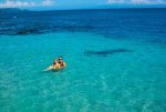
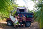
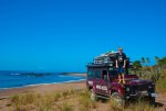
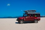
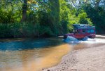
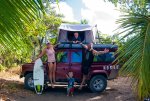
We just finished up 6 amazing days driving down (and back up) the Pacific Coast of Costa Rica. We contacted Nomad America who rents out 4X4 vehicles and they met us in Liberia once we landed with our fully outfitted Defender 110. It had RTT, all camping gear and a winch that thankfully we never used :) We camped 3 nights dispersed on beaches along the way that we found through the IOverlander app and broke up the middle of the trip with 2 night in a "cabina" on the beach. Anyway, if you have 4 1/2 minutes to kill feel free to have a look. We drove miles of dirt road and track, crossed several rivers and drove a few miles of beach. Hopefully the video conveys even a small portion of the amazing adventure we had!
https://www.youtube.com/watch?v=VpNY7V0YBmw&feature=youtu.be
 

rcharrette

Adventurer
Thanks

I was a lot of fun. Here are a few pics as well for those that don't have time for the video.
 

Attachments

  • IMGP7628IMG_6536_final.jpg.jpg
    IMGP7628IMG_6536_final.jpg.jpg
    566.2 KB · Views: 35
  • IMGP7644IMG_6536_final.jpg.jpg
    IMGP7644IMG_6536_final.jpg.jpg
    642.1 KB · Views: 61
  • IMGP7614IMG_6536_final.jpg.jpg
    IMGP7614IMG_6536_final.jpg.jpg
    549 KB · Views: 26
  • IMGP7494IMG_6536_final.jpg.jpg
    IMGP7494IMG_6536_final.jpg.jpg
    505.5 KB · Views: 30
  • IMGP7482IMG_6536_final.jpg.jpg
    IMGP7482IMG_6536_final.jpg.jpg
    443.5 KB · Views: 29
  • IMGP7557IMG_6536_final.jpg.jpg
    IMGP7557IMG_6536_final.jpg.jpg
    602.8 KB · Views: 31
Last edited:

Jeepinaaron

Adventurer
I wish I knew about Nomad America when we went to Costa Rica a few years ago.

Next time! Do you have any details about your route?
 

rcharrette

Adventurer
I wish I had GPS'ed the route this time but didn't think about it. Anyway, we hugged the Pacific coast as much as possible and were able to find the long stretch of beach we drove 7 years ago when we last did this drive. All I can say is follow the route to the Bongo River crossing, after you cross the Bongo River I believe you take the 2nd right and it leads down a rough track right out to the beach. Follow the beach South for few miles (usually other vehicle tracks) and eventually it cut's back off the beach near Playa Hermosa. Lot's of other tracks and trails both along the beach and inland to explore as well. It's the dry season here and we found plenty of rivers to cross :)
I just posted up a few more pic's in the Latin America area but I'll repost here as well.
 

Attachments

  • IMGP7843IMG_6536_final.jpg.jpg
    IMGP7843IMG_6536_final.jpg.jpg
    388.2 KB · Views: 16
  • IMGP7621IMG_6536_final.jpg.jpg
    IMGP7621IMG_6536_final.jpg.jpg
    522.3 KB · Views: 20
  • IMGP7643IMG_6536_final.jpg.jpg
    IMGP7643IMG_6536_final.jpg.jpg
    645.7 KB · Views: 45
  • IMGP7741IMG_6536_final.jpg.jpg
    IMGP7741IMG_6536_final.jpg.jpg
    621.7 KB · Views: 17
  • IMGP7773IMG_6536_final.jpg.jpg
    IMGP7773IMG_6536_final.jpg.jpg
    528.6 KB · Views: 17
  • IMGP7845IMG_6536_final.jpg.jpg
    IMGP7845IMG_6536_final.jpg.jpg
    493.8 KB · Views: 18

1leglance

2007 Expedition Trophy Champion, Overland Certifie
it is hard to access videos while at work...
The pics are great and any other details you care to write about would be a help for future trips..
THanks for posting
 

Yuke

Adventurer
Looks like an awesome trip. Great family picture with the little man front and center!
 

rcharrette

Adventurer
You can take it anywhere in CR and also Nicaragua. Not sure if they allow you to cross the Southern border into Panama you'd have to check out their site.
 

REDrum

Aventurero de la Selva
I think my wife bumped into you all in Manzanillo, she was in our white FZJ80.

All I can say is follow the route to the Bongo River crossing, after you cross the Bongo River I believe you take the 2nd right and it leads down a rough track right out to the beach. Follow the beach South for few miles

FYI, driving on beach from the mouth of the Rio Bongo south is forbidden. Yes, some locals still do it, but that is changing rapidly. (10 years ago the beaches were highways and very dangerous to people and wildlife day and night) Check out http://nicoyapeninsula.com/manzanillo/north.php for the route from Samara thru Betel to Manzanillo to Playa Carmen. In Q1 all the rivers along the non beach route are wadable and rarely over 2 feet deep. But Q2,3,4 (rainy season) they are often at or above 3 feet deep so plan accordingly. And FWIW, The Rio Bongo takes the lives of dozens of cars each year. In rainy season it gets very deep and swift at the south side exit.
 

rcharrette

Adventurer
Thanks for the info REDrum, I had seen this link in our research this time but couldn't really get any solid confirmation. The track out to the beach and drive along is VERY well used, we saw 3 trucks on the way out and 5 on the way back. No signs indicating it was forbidden at all (we were looking!). As you say maybe just by locals though. Anyway, we has a beautiful drive and no problems at all. As far as river crossings of course we were well in the dry season in January and the deepest we saw maybe reached the top of the tires.
 

Triplesnake

Adventurer
That looks like an awesome trip. Thanks for the details. The wife and I were talking just last night about going back to CR.
 

REDrum

Aventurero de la Selva
Thanks for the info REDrum, I had seen this link in our research this time but couldn't really get any solid confirmation. The track out to the beach and drive along is VERY well used, we saw 3 trucks on the way out and 5 on the way back. No signs indicating it was forbidden at all (we were looking!). As you say maybe just by locals though.

Huh? Very surprised Nomad didn't warned you. Law was put int effect in 2009 for all of CR. I'm brining it up because there are a few older tours guides and forum threads that still route driving on the beach and people not knowing are often hit with fines and rage by expats in Santa Teresa. Fine is 120,000 Colones ($210) and 15 points on your license. I've known quite a few who have been whacked. The local still do it, as it is the quickest route from Coyote to restaurant/bar Atardecer Dorado, and locals always get more leeway on laws than gringos. Nicoya 4x4 club posted that section but locals tore them down in days... I've also recovered, twice, rental 4x4s from that stretch, driven by people with no clue.

The southern Nicoya peninsula has been seasonal home for my wife and I for 10 years, happy to provide anyone info on route planning in the area. (albeit with influx of party money to Santa Teresa we are getting priced out, but thats another story…) The frozen in time area between Samara and Manzanillo is one of my favorite places on earth. Pura Vida!
 

Forum statistics

Threads
185,821
Messages
2,878,588
Members
225,378
Latest member
norcalmaier
Top