Florida to Moab` completed

skip371

Observer
Default TransAmericaTrail/ Southwest Trip
Hi,
there seems to be an abundance of people headed to Colorado and the Southwest this time of year. I'm one more. I'm traveling from Florida and will be traveling up and across the panhandle and then head north to join up with the TAT. I have maps from Sam , http://www.transamtrail.com/the-trans-am-trail/ , and due to my somewhat compulsive nature GPS for the Garmin from GPS Kevin. A tablet with Back Country Navigator, BLM,MVUM overlays onboard as well.
The trip on the TAT will end in MOAB with continuation onto a route GPSKevin, http://www.gpskevinadventurerides.com, put together . A loop to the North rim of the GC/Red Rock Vegas.https://www.google.com/maps/d/viewer...6407369996&z=8. My plan is to bypass Vegas.
My travel time is 6-8 weeks. I was initially interested in Ouray and only very recently moved plans to the southwest instead. High pass snow in Colorado is problematic this early in the season. My sone,in Denver, mention a possible snowfall this weekend.
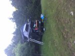
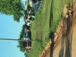
I'm Traveling in a Nissan Xterra PRO4, lifted with lockers and winch, Cooper Tires. A TepuiRTT /ARB fridge and reasonably self sufficient for about 4-5 days at a time. My son will be joining me for a few days in MOAB and then my wife will be flying into Grand Junction for 10 days of seeing Utah. This trip was inspired by this sons adventure ride last year from Denver to Alaska on his Dualsport Yamaha 250.
Of course if the heat becomes too much of an issue to the south I am prepared to reroute. Plans are open to change at anytime and of course suggestions from fellow travelers are always welcome . If your interested here's a link to my route.
http://share.findmespot.com/shared/faces/viewspots.jsp?glId=0vOHqViVcdbdkT9sjxPXvKRMsOISvIxKq
 
Last edited:

skip371

Observer
As with so many plans, months of planning and flexibility is a must . Terrible weather in the Florida Panhandle. Awoke in the RTT to thunder and lightning with heavy rain. I was able to break camp between squals. fog and heavy rain now the news of flooding in Missouri and Arkansas- the route of the TAT. Im rerouting to head to drier route. For new that seems to be west to Texas.
 

skip371

Observer
Today was a drive along the gulf of Mexico. Even in the rain stunning beaches everywhere. Finally consoled myself with a decadent breakfast with a local/shared table in a crowded cool waterside restaurant. She shared her knowledge of all things
"Panhandle".
Returned to dark clouds and frequent heavy rain. I was determined to find clear skies- 10 hours later, i found what I wanted in Louisiana.
When I traveled by motorcycle we called this "the ride to the ride".
Hopefully my plans for riding the TAT will come together soon.
Btw can someone explain how i add a photo to this? Thx
 

skip371

Observer
Forgot to mention that my Tepui did its job, heavy rain , wind- buttoned up and dry. Sitting through the lightening was a little unnerving but unscathed!
 

unkamonkey

Explorer
What you are doing is part of the adventure. You end up where you are. I've been through a lot of that area and have also slept under the PU tailgate in the rain by the Black Canyon of the Gunnison. Tales you can tell.
 

McBride

Adventurer
Awesome! Keep heading west - we love precipitation and it seems like it's following you! I'm heading towards Utah (from Santa Fe, NM on Saturday morning) and I prefer the cooler temps.

I wish I had advice on how to post pics when you are on the road but I don't. Hopefully someone will chime in with specific instructions - we all love the pics.

Safe travels...

William
 

unkamonkey

Explorer
Good luck on your trip.
Let us know where you are in real time and hopefully we can guide you to some good places.
 

skip371

Observer
We visited Santa fe acouple of years ago. We had a great time. We had fun climbing one of the local hills( mountains to us). We were so proud we were hiking one of us commented joking a little, catching our breath. Just then a very skinny guy in short shorts comes flying by us effortlessly :). One of my memories from sf plus amazing food. Catch you in Utah.
 

skip371

Observer
Day 3
The first 2 days totaled 1100 miles, running from a few large storms- trying to find blue skies. On the very end of day 2 I found what I was looking for in Louisiana . I was gaining time as I headed west. Feasted on Jambalaya and Shrimp Etufee. perfect end to a very long day. Day 3 started perfect with cool temps and blue skies. Happy to say it stayed that way. My go to cheerios, fresh blueberries and pecans for breakfast.(gotta love that ARB fridge).
Decided that since the weather was now with me to head north to the TAT. To Shreveport then a hike up to the TAT at mile 372 on Sams maps. Chester.
along the way stopped for gas and found a place with 3 grades with no ethanol and some stellar fried catfish in Mena , AR. Nice folks to boot.
So found the trail without to much fuss, vanilla soft serve  at the trail head. Server said that have people from around the world coming on the TAT. Trail is stunning so far, rolling hills- farms. Everyone has a dog to chase you and bark their greetings. Found a stellar very private site 20 miles or so from the ice cream place. I decided to set up a good campsite and make a real dinner. long walk and some exercise with a couple of bands attached to the truck. Kick back and read and get an early start into Oklahoma tmw.
This is being posted a day late since i have no service at the moment.
Thanks for following along.


Steve
 

Attachments

  • IMG_4248.jpg
    IMG_4248.jpg
    526.5 KB · Views: 28
  • IMG_4233.jpg
    IMG_4233.jpg
    538.3 KB · Views: 19

skip371

Observer
Day4
1610 miles
Today was perfect. Amazing views, wildlife everywhere. Deer that must cross the road now! mules, llamas, goats and of course beef !
Nothing like the junk yard around that next scenic bend to remind me of some of my favorite times back in the day searching for mgb parts.
So many stream crossing I stopped taking pictures. Los of flooding and high water last week.
Road were just graded so most in good shape but two bridges were out. One , with pic included was no go without major retracing route. Luckily Michelle arrived in the nick of time ( yup that pic is Michelle). To open two gates and let me pass around the creek on her property!!
Cant say enough about the spectacular scenery and fun route. After a while I found myself drifting my almost 3 ton xterra around the corners like a rally driver. Major props to Sam the "creator" of the TAT and to gpsKevin for having a decent affordable chip for the garmin. Its not a turn by turn kind of thing but absolutely needed when traveling solo. Oklahoma is different but beautiful as well. Camping in a WMA so hoping no very early hunters. Try to get pics up later
 

skip371

Observer
Day 5 , 150 miles today..more after big steak lunch!

I Wow what a crazy day. Finally getting better at getting the roof top up and down faster. Had a visiter at 3 am reving his engine and taking his time to move on from the dead end i was camping at. A perimeter alarm woke me before i heard him. Quick breakfast and hot the trail. Miles , not acres, of ranches. endless rolling landscapes with ribbons of winding roads for miles. No **** so awesome it was hypnotizing drifting turns in 3rd gear. Missed a few turns doing that. Crazy open range in a few places, steer in the road . The calves ALWAYS run. Adults never move. Mmm - something there. Signs of flooding everywhere. Nice people, whenever I stopped to take in the view, someone would stop to check I was ok- cool rancher in a Cadillac escalade with Raybans, cowboy hat and string tie. The real deal.
All that beef made me want a steak..only place is a ****ty little casino - ribeye on the way. Passed on the 20oz. Btw forgot to mention some crazy cows sitting in the shade, they all seemed to like my music, first about 20... while I hung out having a snack more came running over and linned up for group photo shoot. Hard to see cause most were black. laughed out loud at that one.
Apparently you need wifi to get photos up, not sure why cause they pop right up on dacebook
 

Attachments

  • IMG_4373.jpg
    IMG_4373.jpg
    517.5 KB · Views: 14
Last edited:

skip371

Observer
GONEMOab

A few details then the fun stuff. The event that pushed me to do this trip is called GONEMoab, a Nissan off-road enthusiast group that does this every year. Several non Nissans attend as well. ball park 150 vehicles. Experienced guides and spotters. Ok my truck, I've mentioned a couple of times about the great handling. Credit needs to go to my new set of Cooper Discover S/T Maxx. They have been awesome at shedding gravel and handles the wet and muddy red clay along the way with ease. Very quiet on the 1100 mile trip to the TAT. A 2.5-3 inch lift has custom Alcans out back with extended Bilsteins and Nisstec lifts Mk84' coilovers up front.
On the navigation area I'm using a Garmin Nuvi with GPS Kevins tracks, to support Sam and the work he has done I bought several of his maps as backup. I am using a Nexus7 that I bought used and so far have found"co-pilot" to offer the best info when I need to reroute using the GPS enabled tablet. Feel free to post any questions regarding the vehicle and the way its set up. The Xterra is hugely underrated. It is an extremely capable off road vehicle and in my configuration very comfortable for 600 mile days on blacktop.
once again good fortune has followed me. This evening I needed to stop because A livestock truck was completely blocking the road. I took the opportunity to get out and to stretch and shook hands with James, the grandfather- -we chatted for a while then Jim the grandson came over and introduced himsef . We stood in the road for close to 15 minutes. They were very familiar with the TAT and offered me the opportunity to setup camp on their farm. They have done this for many many others. Met many other members of the family.amazing folks- wow!
 

Attachments

  • IMG_4289.jpg
    IMG_4289.jpg
    527 KB · Views: 13
Last edited:

Forum statistics

Threads
185,424
Messages
2,874,288
Members
224,720
Latest member
Bad Taste
Top