Josh41
Adventurer
Vehicle: Nissan Frontier and FWC

Goal: (Starting in Massachusetts) then- Mt. Rushmore, SD, through Wyoming and then about 3 weeks in CO. As much off road as possible (within the limits of my truck), and only using 1 app.
So far: We have spent some time out west roaming around, MT, CO, and a little ID, can't wait to get back out this summer
Our best resources have been the Fun Trek books and maps, Benchmark maps, and MVUM maps, and reading the threads.

Hardware: Samsung Android Tab E with cellular and GPS, assorted cell phones.
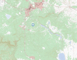
What I would like to do: Upload the maps that I made in Google Earth to Back Country Navigator. Here I have been able to overlay in semi transparency the MVUM maps for the area, see pic below. But I have not been able to upload my map to Back Country, I have tried as a KML and KMZ, but does not seem to be supported. I have taken a look at Gaia but before I drop $39, what is the interface with the MVUM maps like? Does it give all the information that is on the maps? Or, like Back Country Navigator, is it just a lot of lines?

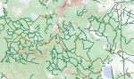
Below: The Tablet using Back Country Navigator, with overlay of MVUM Data, lots of lines, no visible key and none of the info that comes along with the MVUM maps, like which side of the road to camp on, etc. The blue flags are from the FunTrek books.

To summarize, looking for one app that I can use a base map, MVUM maps, and upload my own maps if needed.
Thanks in advance,
Josh
Goal: (Starting in Massachusetts) then- Mt. Rushmore, SD, through Wyoming and then about 3 weeks in CO. As much off road as possible (within the limits of my truck), and only using 1 app.
So far: We have spent some time out west roaming around, MT, CO, and a little ID, can't wait to get back out this summer
Our best resources have been the Fun Trek books and maps, Benchmark maps, and MVUM maps, and reading the threads.
Hardware: Samsung Android Tab E with cellular and GPS, assorted cell phones.
What I would like to do: Upload the maps that I made in Google Earth to Back Country Navigator. Here I have been able to overlay in semi transparency the MVUM maps for the area, see pic below. But I have not been able to upload my map to Back Country, I have tried as a KML and KMZ, but does not seem to be supported. I have taken a look at Gaia but before I drop $39, what is the interface with the MVUM maps like? Does it give all the information that is on the maps? Or, like Back Country Navigator, is it just a lot of lines?
Below: The Tablet using Back Country Navigator, with overlay of MVUM Data, lots of lines, no visible key and none of the info that comes along with the MVUM maps, like which side of the road to camp on, etc. The blue flags are from the FunTrek books.
To summarize, looking for one app that I can use a base map, MVUM maps, and upload my own maps if needed.
Thanks in advance,
Josh