Explorer 1
Explorer 1
Day 5
Being my last day to enjoy the area I decided to strike out by myself and explore some trails and peaks east of Mammoth. That is east enough to be in Nevada.
I started going north to Bridgeport but along the way I wanted to check out the back way into Dog Town right at the exit to Bodie on Highway 395. Dog Town was apparently the first place for placer gold to be found in the eastern Sierra's. All that is left is several piles of gravel, two stone wall and one gravesite.
I continued north on 395 on just outside of Bridgeport I took the well graded road east called Aurora Canyon. At about 7 miles it intersects with a road where a right turn will take you to Bodie,

having already taken that route a few years ago I continue east coming to the California/Nevada border where a well painted sign by Gentry Pace marks the border.


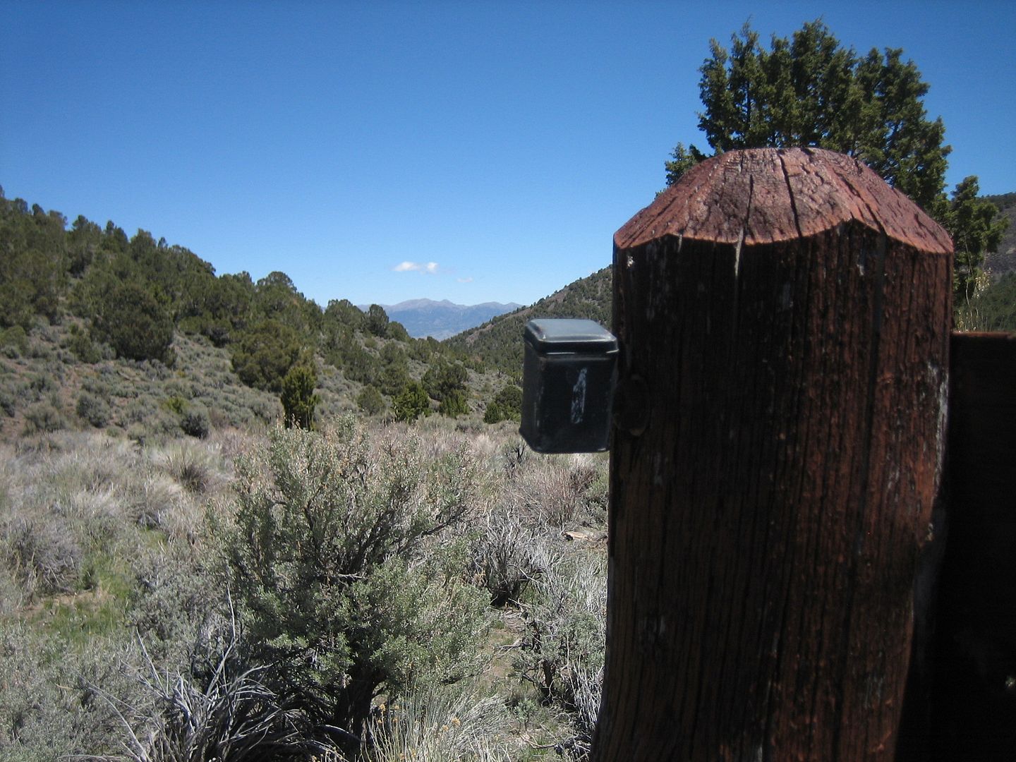
Others have passed this way before, I found someone's geo-cache stuck to the back of the sign. From the log contained within it had been almost two years since there were any visitors.
Continuing east the road ends on Nevada 028, a high speed graded road, I turned right and headed southeast thinking I might visit the Aurora Mine site. Coming to that intersection I was compelled two continue my journey east. I could make out a high peak and a slight trail which from my map indicated it might go all the way to the top. That mountain was Corey Peak , 10,520 elevation, according again to the map. It took a few try to find the correct trail but finally I was convinced I was traveling the right route.
From the condition of the trail I could tell it hadn't been used in recent years. Compound low with occasional rear lockers were called for. As I crossed a saddle I could see that a lower peak adjacent to Corey Peak was a large communications tower for the City of Hawthorne, Nevada.
As the trail climbed it became steeper and steeper to the point that my Tacoma with the rear locked was still unable to make forward movement. Being so close to the top I parked and decide to foot it to the top.
As I attempted to find the highest point I was reminded why my Taco was performing so sluggishly by the way my own heart and lungs were acting at 10,000 feet.
Just before the top I found a small portable building with the door held closed by a rock. Upon removable of this primitive but effective device to keep more simpler animals out.
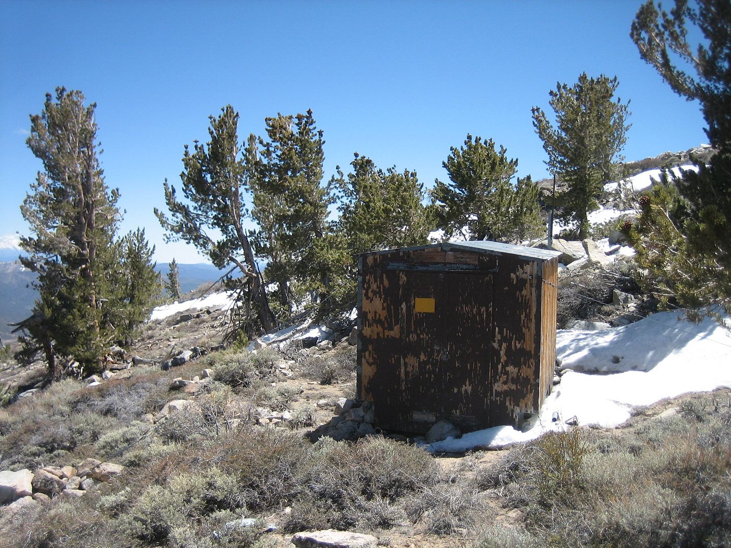
I found what appeared to be some kind of electronic observation station long ago abandoned. There was an old news paper left from a prior occupant indicating the last possible use.

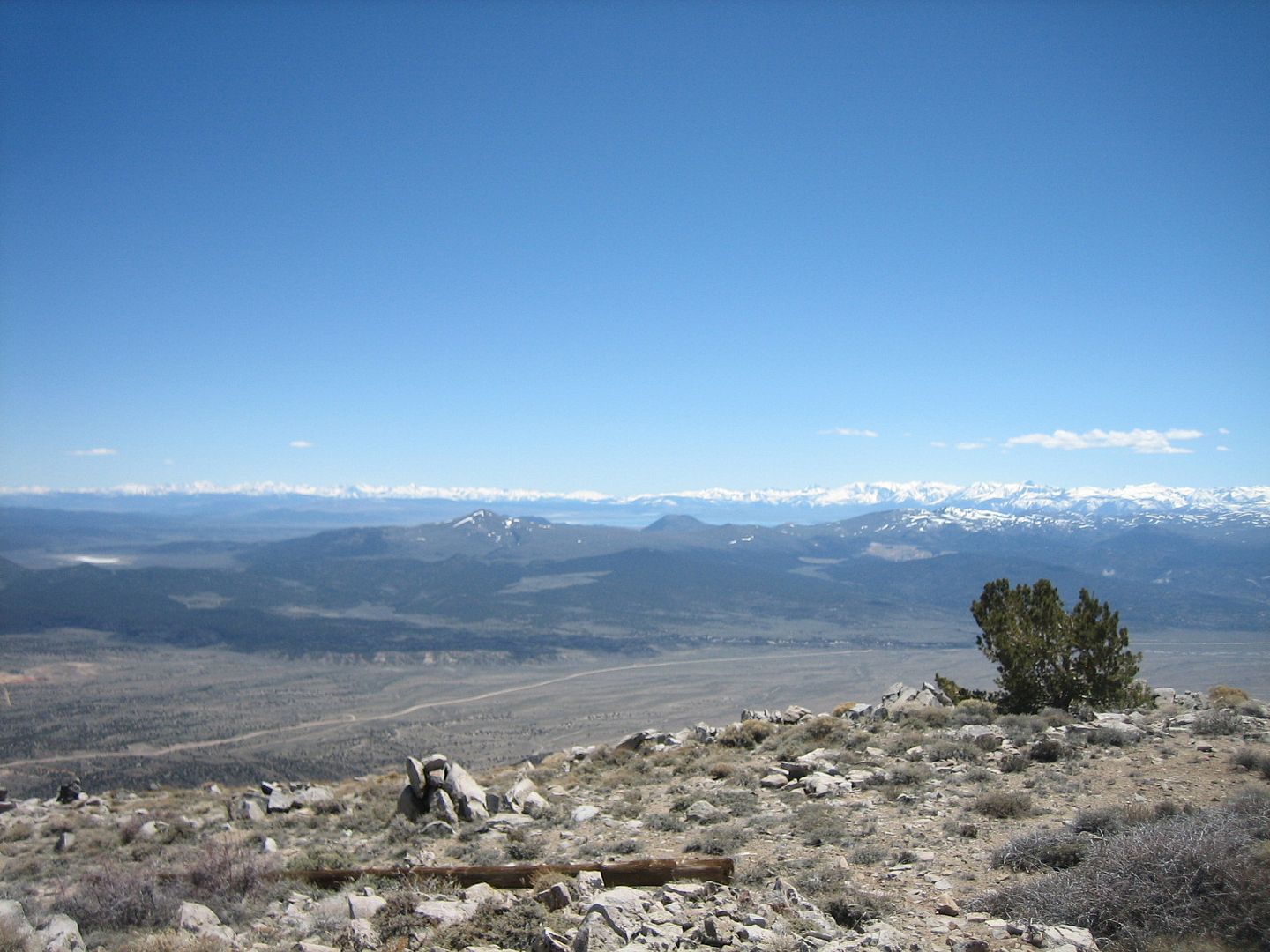
Continuing to the top I found no log book to enter my name, but great views especially west to the distant Sierra's.
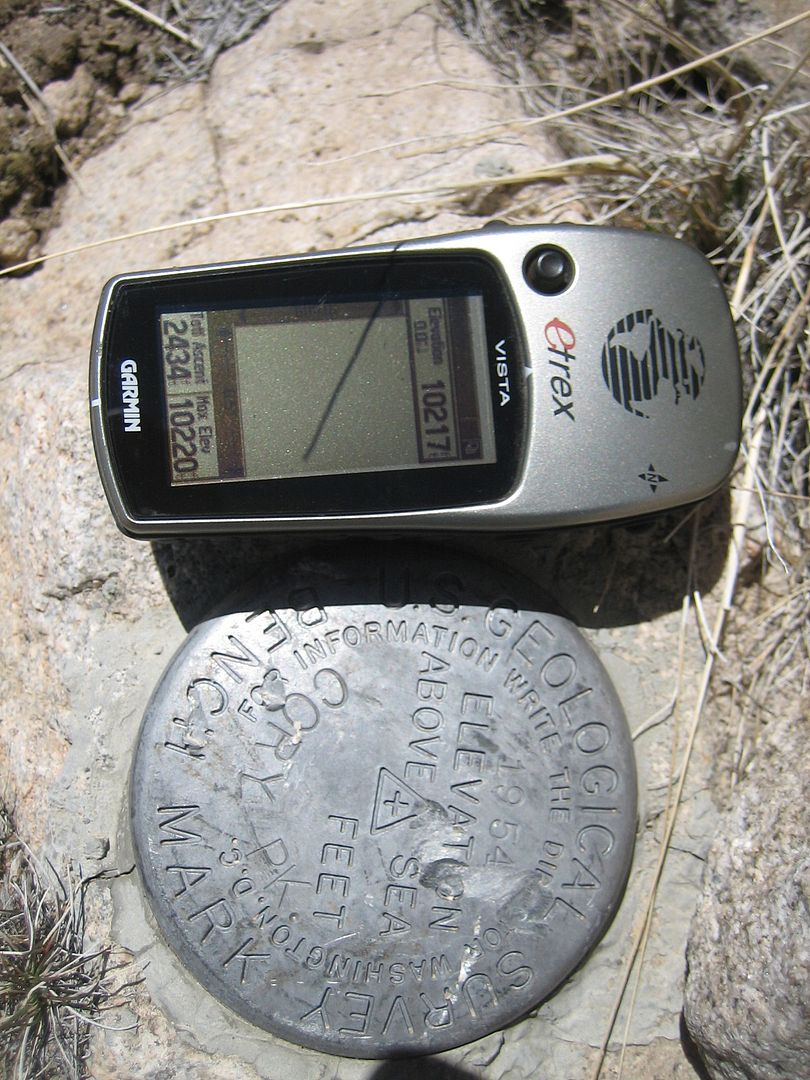
It appears that my GPS has a conflict with the map at to the correct elevation of the Corey Peak. Interesting that the marker also uses a different spelling for the mountain.
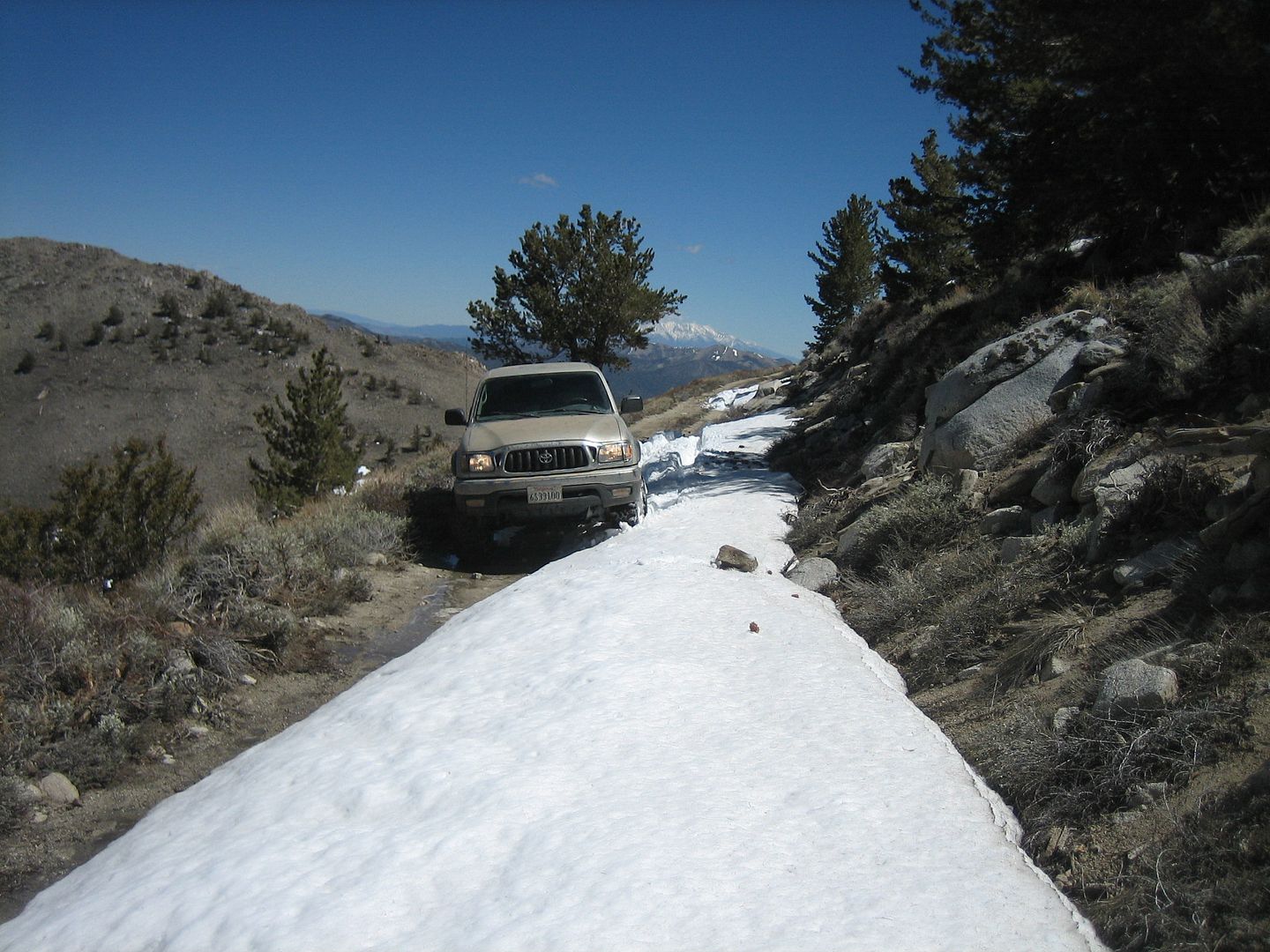
Time to move on so I decided to travel down the steep trail to a shelf road that went around the mountain and joined a road going up to the nearby lower communication complex peak. As I rounded the mountain and came on the south facing side there were more trees due to the natural shade and protection the mountain gave to the plant life from the sun. With the natural shade came a few late season snow drifts still present on the shelf road. I felt ok as it was late afternoon and the snow didn't seem too deep and on this first drift only on my drivers side was I forced to travel on the snow.
OK, first drift.......that wasn't so bad, traction ok, some sideward sliding toward the cliff on my right..........second drift, a little deeper......still ok, a little bit of rear sliding...........third drift a bit wider, time to engage the rear locker, that was a little bit "squirrelly"........final drift to go through........Hmmm. this one almost covers the entire shelf road, let's give it a test and see how deep and how the Taco handles......OK so far but deep enough on the drivers side to stop my forward movement, maybe a little more speed is needed.
Now somewhere in the back of my mind was this very small voice that said (Hey! your out by yourself, you forgot your SPOT tracker, your wife only has a vague idea where you are, you haven't seen another vehicle for hours, it's late in the afternoon and there isn't cell phone service.) The other part of my mind said " did you hear something?
So with a little bit more speed I made better progress right to the middle of the drift before my forward momentum was stopped. That's ok, I'll just back up some and try again.
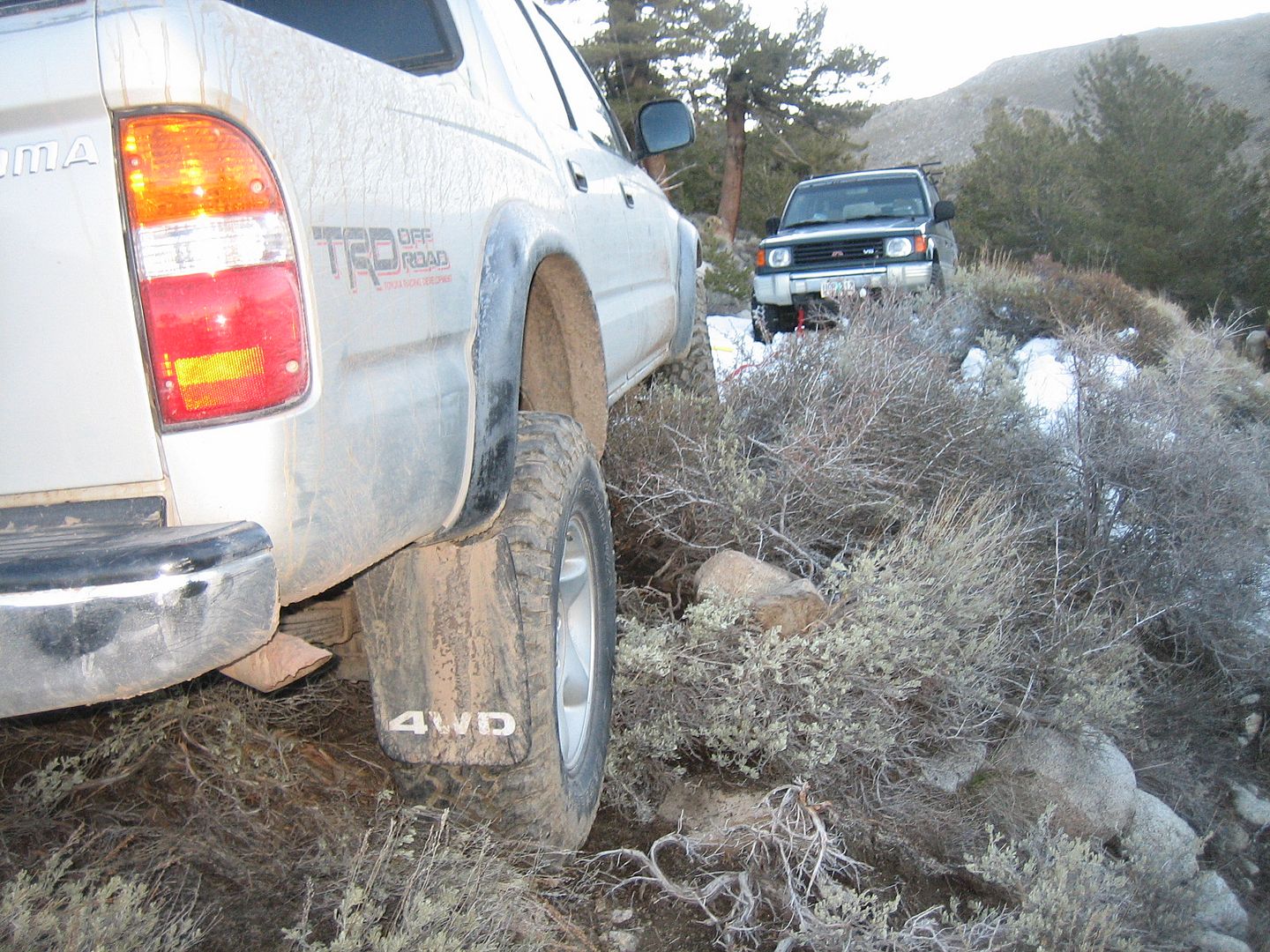
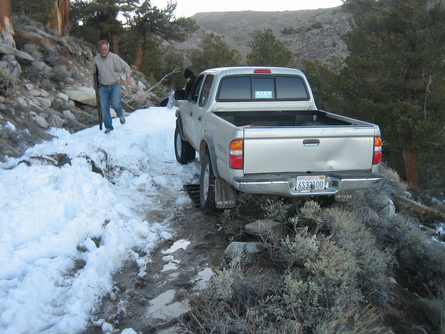
Well unfortunately, my last effort had carried me far enough into the drift to lift my Taco up on part of the drift so when I tried to back up all that happen was the rear tires spun and the back end moved sideways toward the edge of the shelf road drop-off. Using all my prior skills and experience on multiple tries came to no avail soon I was at the point of my passenger rear tire was fully articulated hanging off the edge.
Time for plan "B" (bailout) So with a firm sense in the hopelessness of my current situation and wish for my Cherokee with it's winch and pullpal, I grabbed my survival pack, coat and sweater, tore out the page on the map that gave me some indication of where I was and proceeded at a much slower but reliable pace on foot down the mountain toward what I hoped was a more traveled dirt road and eventually some cell phone service.
From prior experience I knew I walked between 2-3 miles a hours so after 1 1/2 hours I came to a intersection with a better graded dirt road and proceeded down hill. About a half hour on the better road a small dirt bike (motorcycle) passed and I was able to hitch a ride down the mountain to where this dirt road identified as county road 199 ended at Nevada highway 359. This is the same highway as California 167 which runs just north of Mono Lake.
Cell phone service was established so I made contact with my wife giving her instruction on what my, cousin in law, Eugene was to bring up to hopefully assist in my extraction.
The drive from Mammoth to my present location was about 1 1/2 to 2 hours away, so with some time on my hands I proceed to entertain myself by an ever widening circle I walked picking up the abundance litter that seems to find it way to the road side.
It was interesting that the entire time I next to this major Nevada artery only 7 vehicle passed by. Not a single one stopped to inquire why the individual was standing next to the road literally in the middle of nowhere.
Upon arrival of my rescuers we proceeded up the mountain. Late afternoon was upon us, we were in the shade and temperatures were dropping. With our three shovels we went to work and along with the two ramps from my ATV trailer we successfully extracted the Taco.

Darkness fell as we drove back to Mammoth. After all the shoveling and rock moving the hot tub never felt better.
Thanks to Eugene and Bill for coming and bailing me out and to whoever it was that invented cell phones and cell phone sites in wilderness Nevada.
So depending on your frame of reference, I guess I ended my 5 days of off-roading around Mammoth Lakes on a high note or a low note.
"The difference between an adventure and ordeal, is your attitude." :ylsmoke:
Thanks,
Fred
Explore 1
Being my last day to enjoy the area I decided to strike out by myself and explore some trails and peaks east of Mammoth. That is east enough to be in Nevada.
I started going north to Bridgeport but along the way I wanted to check out the back way into Dog Town right at the exit to Bodie on Highway 395. Dog Town was apparently the first place for placer gold to be found in the eastern Sierra's. All that is left is several piles of gravel, two stone wall and one gravesite.
I continued north on 395 on just outside of Bridgeport I took the well graded road east called Aurora Canyon. At about 7 miles it intersects with a road where a right turn will take you to Bodie,
having already taken that route a few years ago I continue east coming to the California/Nevada border where a well painted sign by Gentry Pace marks the border.
Others have passed this way before, I found someone's geo-cache stuck to the back of the sign. From the log contained within it had been almost two years since there were any visitors.
Continuing east the road ends on Nevada 028, a high speed graded road, I turned right and headed southeast thinking I might visit the Aurora Mine site. Coming to that intersection I was compelled two continue my journey east. I could make out a high peak and a slight trail which from my map indicated it might go all the way to the top. That mountain was Corey Peak , 10,520 elevation, according again to the map. It took a few try to find the correct trail but finally I was convinced I was traveling the right route.
From the condition of the trail I could tell it hadn't been used in recent years. Compound low with occasional rear lockers were called for. As I crossed a saddle I could see that a lower peak adjacent to Corey Peak was a large communications tower for the City of Hawthorne, Nevada.
As the trail climbed it became steeper and steeper to the point that my Tacoma with the rear locked was still unable to make forward movement. Being so close to the top I parked and decide to foot it to the top.
As I attempted to find the highest point I was reminded why my Taco was performing so sluggishly by the way my own heart and lungs were acting at 10,000 feet.
Just before the top I found a small portable building with the door held closed by a rock. Upon removable of this primitive but effective device to keep more simpler animals out.
I found what appeared to be some kind of electronic observation station long ago abandoned. There was an old news paper left from a prior occupant indicating the last possible use.
Continuing to the top I found no log book to enter my name, but great views especially west to the distant Sierra's.
It appears that my GPS has a conflict with the map at to the correct elevation of the Corey Peak. Interesting that the marker also uses a different spelling for the mountain.
Time to move on so I decided to travel down the steep trail to a shelf road that went around the mountain and joined a road going up to the nearby lower communication complex peak. As I rounded the mountain and came on the south facing side there were more trees due to the natural shade and protection the mountain gave to the plant life from the sun. With the natural shade came a few late season snow drifts still present on the shelf road. I felt ok as it was late afternoon and the snow didn't seem too deep and on this first drift only on my drivers side was I forced to travel on the snow.
OK, first drift.......that wasn't so bad, traction ok, some sideward sliding toward the cliff on my right..........second drift, a little deeper......still ok, a little bit of rear sliding...........third drift a bit wider, time to engage the rear locker, that was a little bit "squirrelly"........final drift to go through........Hmmm. this one almost covers the entire shelf road, let's give it a test and see how deep and how the Taco handles......OK so far but deep enough on the drivers side to stop my forward movement, maybe a little more speed is needed.
Now somewhere in the back of my mind was this very small voice that said (Hey! your out by yourself, you forgot your SPOT tracker, your wife only has a vague idea where you are, you haven't seen another vehicle for hours, it's late in the afternoon and there isn't cell phone service.) The other part of my mind said " did you hear something?
So with a little bit more speed I made better progress right to the middle of the drift before my forward momentum was stopped. That's ok, I'll just back up some and try again.
Well unfortunately, my last effort had carried me far enough into the drift to lift my Taco up on part of the drift so when I tried to back up all that happen was the rear tires spun and the back end moved sideways toward the edge of the shelf road drop-off. Using all my prior skills and experience on multiple tries came to no avail soon I was at the point of my passenger rear tire was fully articulated hanging off the edge.
Time for plan "B" (bailout) So with a firm sense in the hopelessness of my current situation and wish for my Cherokee with it's winch and pullpal, I grabbed my survival pack, coat and sweater, tore out the page on the map that gave me some indication of where I was and proceeded at a much slower but reliable pace on foot down the mountain toward what I hoped was a more traveled dirt road and eventually some cell phone service.
From prior experience I knew I walked between 2-3 miles a hours so after 1 1/2 hours I came to a intersection with a better graded dirt road and proceeded down hill. About a half hour on the better road a small dirt bike (motorcycle) passed and I was able to hitch a ride down the mountain to where this dirt road identified as county road 199 ended at Nevada highway 359. This is the same highway as California 167 which runs just north of Mono Lake.
Cell phone service was established so I made contact with my wife giving her instruction on what my, cousin in law, Eugene was to bring up to hopefully assist in my extraction.
The drive from Mammoth to my present location was about 1 1/2 to 2 hours away, so with some time on my hands I proceed to entertain myself by an ever widening circle I walked picking up the abundance litter that seems to find it way to the road side.
It was interesting that the entire time I next to this major Nevada artery only 7 vehicle passed by. Not a single one stopped to inquire why the individual was standing next to the road literally in the middle of nowhere.
Upon arrival of my rescuers we proceeded up the mountain. Late afternoon was upon us, we were in the shade and temperatures were dropping. With our three shovels we went to work and along with the two ramps from my ATV trailer we successfully extracted the Taco.
Darkness fell as we drove back to Mammoth. After all the shoveling and rock moving the hot tub never felt better.
Thanks to Eugene and Bill for coming and bailing me out and to whoever it was that invented cell phones and cell phone sites in wilderness Nevada.
So depending on your frame of reference, I guess I ended my 5 days of off-roading around Mammoth Lakes on a high note or a low note.
"The difference between an adventure and ordeal, is your attitude." :ylsmoke:
Thanks,
Fred
Explore 1
")