IntrepidXJ
Explorer
Friday - Sunday, October 24-26, 2014
Since Diane and I had a great long weekend in The Maze over Memorial Day weekend I wanted to show her some of my favorite places in The Needles district this weekend so she could experience more of Canyonlands National Park. Plus, I've been having a great year in Canyonlands by finally completing the White Rim and backpacking Salt Creek Canyon, so I wanted to keep the momentum going!
I left work early Friday morning and we made our way through Moab and Indian Creek Canyon to The Needles. Of course, we stopped at Newspaper Rock along the way to check out the impressive petroglyph panel. After arriving at the park, we hiked the short Cave Spring trail before driving over Elephant Hill to our campsite for the next two nights in the Devil's Kitchen. The beginning of the Elephant Hill trail was the easiest I have ever seen it. It appears that the Park Service has removed the large loose boulders that would constantly move and then filled the trail in with sand and dirt.
I've stopped at Newspaper Rock numerous times in the past, but it's always worth another quick visit when I'm driving by.

Newspaper Rock Petroglyphs by IntrepidXJ, on Flickr
The cowboy camp at Cave Spring.

Cave Spring Cowboy Camp by IntrepidXJ, on Flickr
A few small pictographs near Cave Spring.

Cave Spring Pictographs by IntrepidXJ, on Flickr
Along the Elephant Hill trail on our way to camp.

Elephant Hill Trail by IntrepidXJ, on Flickr
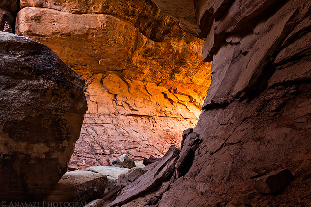
When we reached our campsite at the Devil's Kitchen there was some nice reflected light in the passages and slots behind our camp. I quickly grabbed my camera and tripod to take a few photos since I knew the light wouldn't last long.

Entrance by IntrepidXJ, on Flickr

Camp Chamber by IntrepidXJ, on Flickr

Intersection Glow by IntrepidXJ, on Flickr

Passage Light by IntrepidXJ, on Flickr

Fun With Light by IntrepidXJ, on Flickr
While I was taking photos of the reflected light, Diane was nice enough to get our tent setup all by herself.

Devil's Kitchen #3 by IntrepidXJ, on Flickr
The sky was clear when the sun went down, so I really didn't bother taking any photos at that time. However, I did wait until it was dark enough to take some shots of the Milky Way above.
The Milky Way over Devil's Pocket from camp.

Needles Milky Way by IntrepidXJ, on Flickr
Diane was inside the tent reading while I took this photo.

Night Camp by IntrepidXJ, on Flickr
On Saturday morning we woke up with the sunrise, but there were no clouds again, so I didn't take any photos. Instead we had some breakfast and started our drive through Devil's Lane and over SOB Hill to the Joint Trail. We stopped at a few rock art sites on the way.
A well-known panel of pictographs right next to the road.

Hands & Feet by IntrepidXJ, on Flickr
Part of a larger Barrier Canyon Style pictograph panel that is very faded and hard to see.

Grabens Panel by IntrepidXJ, on Flickr
We enjoyed the short morning hike on the Joint Trail to the Chesler Park overlook and rested there in the shade. After a little while we heard and saw a large group of kids hiking through Chesler Park in the distance on their way towards the Joint Trail and we knew that it was time to get moving again. We did not want to get stuck near that group!
Entering the Cave of Cairns. There aren't as many cairns as there used to be in here. I've seen the Park Rangers knocking them over in the past.

Cave of Cairns by IntrepidXJ, on Flickr
Some nice light around the corner.
Cave Glow by IntrepidXJ, on Flickr
Trail through the joint.

Joint Trail by IntrepidXJ, on Flickr

The Joint by IntrepidXJ, on Flickr
Our view from the Chesler Park overlook. Maybe one day I'll finally catch a sunset here, but not today...

Chesler Park by IntrepidXJ, on Flickr
Diane heading back to the trailhead.

In the Joint by IntrepidXJ, on Flickr
Since Diane and I had a great long weekend in The Maze over Memorial Day weekend I wanted to show her some of my favorite places in The Needles district this weekend so she could experience more of Canyonlands National Park. Plus, I've been having a great year in Canyonlands by finally completing the White Rim and backpacking Salt Creek Canyon, so I wanted to keep the momentum going!
I left work early Friday morning and we made our way through Moab and Indian Creek Canyon to The Needles. Of course, we stopped at Newspaper Rock along the way to check out the impressive petroglyph panel. After arriving at the park, we hiked the short Cave Spring trail before driving over Elephant Hill to our campsite for the next two nights in the Devil's Kitchen. The beginning of the Elephant Hill trail was the easiest I have ever seen it. It appears that the Park Service has removed the large loose boulders that would constantly move and then filled the trail in with sand and dirt.
I've stopped at Newspaper Rock numerous times in the past, but it's always worth another quick visit when I'm driving by.
Newspaper Rock Petroglyphs by IntrepidXJ, on Flickr
The cowboy camp at Cave Spring.
Cave Spring Cowboy Camp by IntrepidXJ, on Flickr
A few small pictographs near Cave Spring.
Cave Spring Pictographs by IntrepidXJ, on Flickr
Along the Elephant Hill trail on our way to camp.
Elephant Hill Trail by IntrepidXJ, on Flickr
When we reached our campsite at the Devil's Kitchen there was some nice reflected light in the passages and slots behind our camp. I quickly grabbed my camera and tripod to take a few photos since I knew the light wouldn't last long.
Entrance by IntrepidXJ, on Flickr
Camp Chamber by IntrepidXJ, on Flickr
Intersection Glow by IntrepidXJ, on Flickr
Passage Light by IntrepidXJ, on Flickr
Fun With Light by IntrepidXJ, on Flickr
While I was taking photos of the reflected light, Diane was nice enough to get our tent setup all by herself.
Devil's Kitchen #3 by IntrepidXJ, on Flickr
The sky was clear when the sun went down, so I really didn't bother taking any photos at that time. However, I did wait until it was dark enough to take some shots of the Milky Way above.
The Milky Way over Devil's Pocket from camp.
Needles Milky Way by IntrepidXJ, on Flickr
Diane was inside the tent reading while I took this photo.
Night Camp by IntrepidXJ, on Flickr
On Saturday morning we woke up with the sunrise, but there were no clouds again, so I didn't take any photos. Instead we had some breakfast and started our drive through Devil's Lane and over SOB Hill to the Joint Trail. We stopped at a few rock art sites on the way.
A well-known panel of pictographs right next to the road.
Hands & Feet by IntrepidXJ, on Flickr
Part of a larger Barrier Canyon Style pictograph panel that is very faded and hard to see.
Grabens Panel by IntrepidXJ, on Flickr
We enjoyed the short morning hike on the Joint Trail to the Chesler Park overlook and rested there in the shade. After a little while we heard and saw a large group of kids hiking through Chesler Park in the distance on their way towards the Joint Trail and we knew that it was time to get moving again. We did not want to get stuck near that group!
Entering the Cave of Cairns. There aren't as many cairns as there used to be in here. I've seen the Park Rangers knocking them over in the past.
Cave of Cairns by IntrepidXJ, on Flickr
Some nice light around the corner.
Cave Glow by IntrepidXJ, on Flickr
Trail through the joint.
Joint Trail by IntrepidXJ, on Flickr
The Joint by IntrepidXJ, on Flickr
Our view from the Chesler Park overlook. Maybe one day I'll finally catch a sunset here, but not today...
Chesler Park by IntrepidXJ, on Flickr
Diane heading back to the trailhead.
In the Joint by IntrepidXJ, on Flickr


")