Big Bear Camping in the ADV80 - Oct 4-5th, 2008

GCRad1

Adventurer
2917548854_327001fa30.jpg

Sometimes you just have to GO! Sometimes you have to just DO IT! Sometimes it's a slight "throw-together" along with the right persuasion... persuasion to the kids...

The wife is working Saturdays and is not all that fond of the "roughing it" and especially in foul weather much less cold foul weather.

The kids on the other hand are typically game for anything once.
2916706151_e6cb63125e.jpg

My two daughters ages eight and twelve love to go wheelin and living here in Southern California's beach area, wheelin on dirt roads requires a little driving, with Saddleback / Santa Ana Mountains as our quick-ADV-escape. But with over half of Saddleback being closed, we wanted to get out and see more and toss in an over-night camping trip. Girls where GAME!!!

The ADV80 is loaded and off we go!
2917550386_34732d49a3.jpg

Nice Scooby on the 91FWY. Too bad it dosn't have mud flaps and rally tires...
traffic traffic traffic... one day, with planned time permitting, I want to make a trip from beach to mountains without the use of the SO-CAL FWAY System - across Saddleback to Lake Mathews - Moreno Valley - Redlands - etc. But that is a whole 'nother trip...

2917550632_bdb14e2249.jpg

Big Bear Mountains in the distance with gray clouds painted rather close! The weather is calling for RAIN but we are going anyhow! No turning back now!!!

2916707915_501db026a0.jpg

HWY 330 - San Bernardino National Forest sign. Like I needed to tell you guys that... but hey, we are noobs! But I do have my fair share of driving past this sign from years of going snowboarding... just never camping, so it's a whole new trip for me. I have only had one other ADV outting in Big Bear on the motorcycle back in Oct 2007. I need to spend way more time up here!!!

2917551200_c77dda5b0b.jpg

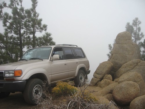
The fog is getting heavy! Clouds are swirling all around as we climb up the HWY330 mountain road and I'm trying to find the cut-off for the 1N09 that should be on the right side.
 
Last edited:

GCRad1

Adventurer
2916709595_4fe89db152.jpg

So, did not find the 1N09 off HWY330. Find this 'nother dirt road and off to Keller Peak Fire Lookout.

2916708411_8ce6a52744.jpg

IT's FOGGY - what is there going to be to see? Aside from the view, just to check out the Fire Lookout station itself was cool enough and leaves reason to go back again at a later date.

2917551700_4c5352b84a.jpg

Humming Birds feeding off the ledge of Keller Peak Fire Lookout.

2917553026_8f9e9a3cd3.jpg

2916712199_d1ebf9c59e.jpg

Self-gloating shot... but look at the texture, color and.. and... and...

THE FOG!
2917555460_beb58cb9a4.jpg


OK, so on to the next location... back out and on into Big Bear and cut up Knickerbocker Rd. Just up the hill is a dirt road on the left and up the twisty dirt road scenic views overlooking Big Bear lake are to be had quickly as the elevation gain is quick. This also make for a great decent for many mountain bikers so be very careful as they do not scrape off as easily as masquito's!
2916713263_1ca313b93a.jpg

The 2N51Y [to the left] takes you up the side of Snow Summit Ski Lift area and you will actually see off to the left one of the Lifts running up the side of the mountain. The hope was to run up to the top of Moonridge, but met with a closed gate. Need to go back and explore if we can make it down the backside of the mountain on the 2N06 into the Camp Sky Meadow area...

2916713727_f5c0b18113.jpg

Spot a dear along the 2N10 road on the way back across the ridge. We actually spotted four more dear a bit later. the girls where excited to see these animals in the "wild" natural habitat.
 

GCRad1

Adventurer
2916714951_66cff48809.jpg

Part of exploring and not keeping track of what road you cut off of is part of the fun of not remembering exactly where you where, but close enough to know it was off the 2N10, but if ever we see it again we will know it when we see it. This road actually choked down into a dirt bike trail that made a sharp decent down the powerlines going down the side of the mountain.

2916715327_baee5450b5.jpg

Some hitch hiker in the middle of the woods. At least he had a chair...

It's getting late in the day and finding a camping location becomes priority...
2916716039_d7bfb57c46.jpg

We pull into any cut-off for spot location check. From here we head to Dear Group Camp and Camp Osita Ranch Camp and as we check these camps out, to my surprise the girls want to find a location not crowded with people. They wanted to camp out like the images of camps I've shown them from this site. The camps we rolled into had some big family groups in there, the girls wanted what I was also hoping for - primitive and "all ours" yet, I thought it would be a "fat chance".

So off down another road in search of the great pumpkin patch!
2916718693_023f415ddb.jpg

this would be the little 1N54A AKA - CAR WASH!
2917562860_e4ec84491a.jpg

obviously...

The 1N54A was not that good for the overly-fat-UTV-ADV80 and it just squeezed down to a MX bike trail so when a clearing opened up, we turned around.

2917564822_d7bc41d700.jpg

Climbing back out of the 1N54A toward 2N10 main ridge resulted a spectacular view..
2916722057_5150ffda55.jpg

of the sky /clouds /fog rising up and over the ridge - 1N54A. AWESOME!!!
Yes, even the girls at there young age appreciated such spectacular nature in slow motion.

2917565632_5cb341a937.jpg

Que music: Going back through the car wash to get the left side this time.

FINALLY!!!
2917566352_4ba6f3879b.jpg

After visiting a few camp sites, we finally find what we are looking for, a site where there are no other people - RARE, but we found it! OK, sorry, off to get the girls in bed - more to come...
 

jl8088

Adventurer
Thank you for the photographs, i've wanted to see what 1N54 (Clarke's Grade) looked like. It looks amazing on maps. Glad you found a place to turn around!

Based on all the overgrowth, it looks like i'll be leaving it for the 2 wheel vehicles!
 

GCRad1

Adventurer
Note the "A" in the 1N54A.
Stay tuned as the 1N54 is AWESOME and coming up in my report as we drove out and down the side of the mountain on day two!!! I will be going back for that nice section of scenic wonder!!!

jl8088 said:
Thank you for the photographs, i've wanted to see what 1N54 (Clarke's Grade) looked like. It looks amazing on maps. Glad you found a place to turn around!

Based on all the overgrowth, it looks like i'll be leaving it for the 2 wheel vehicles!
 

GCRad1

Adventurer
2917566806_65d28f1d7f.jpg

So before the light was completely gone, we got the tent set up. It was sprinkling the whole time.

2917567282_31800fcdf9.jpg

Due to the weather, added some tarp-action.

2917568470_d86a25fa0e.jpg

Got dark quick and the tarp came into some good use as the rain came down late into the night.

2917572108_f13012dbff.jpg

So after the rain came and cleared as the stars popped out around 2:00am... How do I know? Daughter one had to use the "rest room rock" and as we opened the door of the tent, the stars where very BRIGHT!!!!

2917573330_47d19d50c0.jpg

2917575354_349ae8e61a.jpg

FROSTY!!!

2916735013_657042d4f6.jpg

Lexi doing a little rock climbing to work up a breakfast appetite.

2917580144_73f76188e3.jpg

Lexi and me having the morning cereal while Roxy is still sleeping.

2917583276_555efe3133.jpg

2916740325_6fbbdd861a.jpg

The camp spot...

OK, more to come
 

GCRad1

Adventurer
DAY: 2 / October 5th, 2008

DAY: 2 / October 5th, 2008
2916742229_638c80c02f.jpg

It's an awesome day, the chill breaks as the sun warms, we break camp and make ready for another day of wheelin' in Big Bear!

We drive into town, gas up and make our way across the lake and hit the 2N09 at Polique Canyon. The girls notice right away that this is a rougher road than the roads from the south side of the lake.

We cut through the woods to Holcomb Valley:
2916742931_517674a680.jpg

Just to the right of the horses was a fox laying in the shade. I think he was very comfortable hanging out with the big horses.

But over on the opposite side, the side we had just came from... A little road kept creeping into my head..
2916744621_9f9f54846f.jpg

We did a loop around in Holcomb Valley, but in the back of my head, I was still interested in connecting that 1N09 to the HWY-330. So here we are back on the south rim going up 2N08 to the 2N10 and then to the 1N54 and find out way from there.
 
Last edited:

Atticus_1354

Adventurer
Glad your girls are up for a little adventure. My favorite childhood memories are from family camping with my sisters and parents. Now that we are all older we still camp. In fact I'm heading to Big Bend tomorrow with my sisters. Hopefully your kids will continue on with that spirit.
 

GCRad1

Adventurer
Day 2

SO, back to the top of the mountain we go...
2917588912_d3ee81814c.jpg

The view from 2N10 into the San Goronio Wilderness. I had no idea there was this whole other area to explore!!!

2916745609_65d7cbfdf6.jpg

A view of the Barton Flats area as we get further out on the ridge.

2917590044_45c4a08247.jpg

On the way down the 1N54.

2917590600_7644616211.jpg

Another view across the Barton Flats from 1N54.

2917591288_5b5277cf0e.jpg

WE JUST CAME DOWN THAT!!! If you did not know there is a road-trail on the side of this mountain, you would not believe it. AND the views are AWESOME!

2917591894_b0a3da94e9.jpg

Another view of the 1N54 hidden in the trees.

2917592492_68664b7ea5.jpg

Another view from the 1N54 looking towards Redlands [West].

2916750683_d314eb0ed2.jpg

1N54 with San Gorgonio Wilderness in the background.

2917597736_48dd61a642.jpg

Lots of terrain change on this trail - 1N54.

2917600414_56db63584a.jpg

Stream crossing on the 1N54.
 

KC Cruiser

Adventurer
Great post! Taking my 2 girls tomorrow after work. They are only 2.5 and 6 months, but they love being outdoors. Good for you for getting them out there:smiley_drive:
 

GCRad1

Adventurer
Day 2

2916759451_ed43608f45.jpg

At this point, i think we are on the 1N64 looking back at the 1N54. I say "think" because it was not clearly marked at intersections, but I am heading in the direction of the 1N09.

2916759919_3b3136bc6c.jpg

Looking ahead to where we are going at what might be Harrison Mountain. Not sure...

2917604186_ec178df848.jpg

Two trees in the flats... It say's SEVEN PINES on the map... I think we are on the 1N10 and there is a 1N10A and 1N10B and the map just shows 1N10 and they trail is not marked so well... pick and choose.

Choice #1, "go to the right dad!"
2917604756_cfced8a0d4.jpg

Yea, this is a dead end, not the way we want to go, but still cool views. I think this is Bear Creek?

Out and onward:
2916761245_db6aa2a738.jpg

Looking down the toward Redlands again. I think that is Santa Ana River down there?

2917606256_34e1daea8f.jpg

Honestly, I think we are on the 1N09, but I do not know the creek area we are about to drop into? Fredalba Creek?

2916763295_06f06e6fe0.jpg

According to the map, we look close to the 330FWY - Mill Creek?

2917607896_30e3cc90aa.jpg

Nice view up the dry creek bed, but by the size of it, it must be LARGE when the water is at it's peek!

2917609434_8442ef3c2f.jpg

The bridge... headed in the wrong direction as the connecting dirt road on the other side of the creek was closed and LOCKED! WE ARE SO CLOSE - I can feel it!!! Locked gate means we will be driving back out and around to hopefully find another way out without having to drive back over the mountain and back into Big Bear... Mean time, we take a break and enjoy the views...
2917610784_47d0d92351.jpg
 

Forum statistics

Threads
189,824
Messages
2,921,322
Members
232,931
Latest member
Northandfree
Top