Frankspinz
Adventurer
Ishpatina Ridge is the highest geographical point in the Province of Ontario, Canada. Not much of a climbing challenge at 693meters. The real challenge lies in getting there. The ridge is in a remote region of Temiscami. The nearest roads are for logging, so they are built, used then abandoned. The roadmap changes yearly!
To plan my trip, I read the various stories on the internet about Ishpatina Ridge. I was traveling solo, approaching by 4x4 as far as I could drive. Then canoe & portage to the trailhead, camp, & hike to the summit.
Some people have done the 4x4 part on bicycle and bushwacked to the Ridge. I was hoping the canoe route would be easier.
I expected a long (3-4 days) and difficult trip. So I planned accordingly. Minimal equipment, but I gave myself ample leeway for stove fuel and food if I had to spend 24 or 48 extra hours in the woods. I also plan for cold and wet weather despite a more than favourable forecast. Mid October temperatures are below freezing at night.
I drive a modified Nissan Xterra 4x4, on 33” BFG, with full recovery gear. On the roof rack, my 15' Kevlar expedition canoe from Swift. My gear is all stowed in a 70litre dry bag.
I leave Ottawa, Friday, October 8, 2010 around 12:30. The roads are not too busy, I drive on the Ottawa River Parkway with stunning views of the Ottawa River. I quickly regain the 417 westbound - Sudbury will be seen in about 7 hours ...
I am surprised by the beautiful scenery. Towns and villages pass by, all household names but never visited: Arnprior, Pembroke, Petawawa, Chalk River. The northern access roads to Algonquin Park surprise me, so many places to visit ... another day perhaps ... I wonder why I'm driving so far when there are many beautiful and interesting places closer to home... But the highest Ontario summit beacons!
North Bay, the shores of Lake Nipissing offer great views of this vast body of water... Sudbury in less than 130km... The sun goes down too fast! But I keep a good cruising speed on the well maintained tarmac of highway 17.

On the outskirts of Sudbury (Intersection Hwy 17 and Hwy 93, in: 46.494286, -80.846715), I fill up the truck and complete my grocery shopping. There is even a LCBO (wine & spirits) and I let myself be tempted by a bottle of wine that I leave in the Xterra to celebrate my success to my return, or drown my sorrow in case of failure !
I then take Hwy 90 north to Capreol, Around 1900hrs, it is getting dark ... Just at the entrance of the village a fox crosses the road and a few seconds later, a black bear! I hope this is a good omen !
I find without much trouble Opy's Central Variety (46.708176, -80.919521) where I stop to purchase my backcountry permits to the Lady Evelyn Smoothwater Provincial Park. The Ridge is in park territory and a permit is necessary for camping. It is also added security (I guess) if I don't make it back out in my allotted time
At Capreol, you can buy gasoline and there is also an LCBO ... 1930h - I drive Portelance road leading towards the shore of Little Sacrecrow Lake...
I'm driving a path that I loaded in my GPS from different sources namely the story of Andrew in 2006 that I have read in my preparations ... (http://alavigne.net/Outdoors/ImageGallery/2006/06-03-IshpatinaRidge/index.jsp?navpage=5) This is where the success or failure of my endeavour can be determined very early on. The dirt track is in pretty good shape, but I am driving in 1st & 2nd gear more than I would like! Many areas are flooded due to beaver activity and crossing water of unknown depth at night (I really need to buy extra lights for the truck!) is nerve-racking !
I surprise a moose that runs in front of my Xterra over a good distance. Whenever I stop to give him a chance to escape in the woods, he also stops. I lose sight of him once, only to realize he's right next to me. We avoid the collision and he resumes his wild run ... I don't want to tire him out as it is hunting season... Finally, he turns into the forest ... I wish him good luck and drive on.
It really takes a good 4x4 to travel this road, a bridge is washed out. The road ends ... I walk a bit to find a narrow path where ATVs have crossed the river. I engage 4low, and drive on. There's always the winch if I can't get across. The water isn't very deep, but the shore is a steep slope. My BFGs do a great job and I am soon on my way again. , many obstacles and two rivers crossed, I get to Little Scarecrow Lake around 22:30. The starry sky is unlike any I have seen in a long time !
23:00, Florin (the dog) and I get settled in the back of the Xterra for the night ...


October 9, 2010, my alarm set for 7:30, sounds ... The nights sleep was restfull. The sunrise promises a super great day. Breakfast time as I organize all my equipment. I plan to start paddling around 09:00. It froze during the night but the sun quickly warms me. I paddle up what I believe to be the discharge of Woods Lake, I portage over a beaver dam, I soon realize that I am wasting time exploring a dead end!
I turn around and find the right path. Here, I make up time getting the canoe upstream of the discharge. I can not paddle, there are only a few inches of water and too much current ... Florin is enjoying the ride as I drag the canoe up the little steam. I am very happy with the hip waders, I bought just for this purpose.
I soon come to a wall of rocks ... I do not see a portage trail, so I ground the canoe in a likely place and proceed to carry my 70 litre dry bag past the rocks. It's a big effort to portage through very dense woods with lots of dead fall. 2nd trip, I carry, I pull, I push and drag the canoe 350 m to Woods Lake... I've wasted a lot of time here ... It's noon and I'm hungry, but I do not want to stop and open my bag to eat. I decide to continue ... I'm hoping to make it to the top of Ishpatina today. So I need to press on.
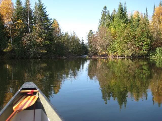
Woods Lake is quickly traversed, and also the creek that leads to Scarecrow Lake. I'm paddling at an average speed of 5km / h on the lake, I'm encouraged, yet still hungry ... I pass the small island where there's one of the campsites, (47.281107, -80.757194). I can see the tower in the distance ... very far away!
1:00 p.m. arriving at the camp. A little garbage lying around, but otherwise a nice setup. I plan to spend the night here comfortably I hope. I eat my pita, tuna, mayo lunch and I prepare my bag for the hike: water food, warm clothes and sleeping bag for the night in case something goes wrong ...

I find the trailhead fairly easily and follow, marked trees with orange "flag" (ribbon). I make a mental note to turn back by 16.00 if I have not yet arrived at the summit. The sunset is expected around 6:45 p.m. AND I do not want to be surprised by darkness.The trail passes next to three small lakes and swamps and I manage to keep my feet dry - BONUS... Not a single bug to bite me, beautiful fall colours, crisp air ! What a great time of year to be here.

3.5km walked and 1.5 hours later, I see the fire tower on the summit through the branches,

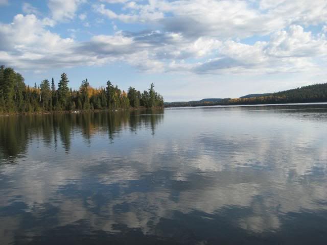
the trail leads me on a few more turns and I come to the base of the abandoned fire tower... The view from the summit is spectacular. I snack, explored, dry off my soaked shirt. I find the two water bottles filled with messages from the people that have been here before me...

Summit view of Scarecrow Lake:

4:00 p.m. comes and goes, it's time to descend. My timings are good! I'll have time to fix dinner and set-up camp before dark.
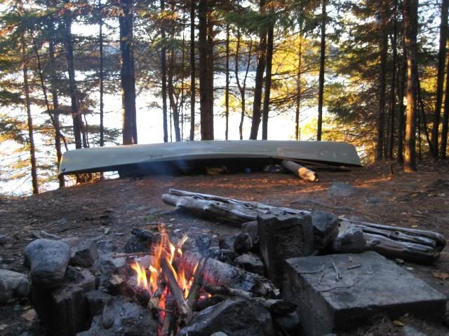
Back at the camp, 18:30 - unable to pump my stove Peak1 (naphtha) ... The plunger should be lubricated and I do not have oil... In my dry bags I dig, dig, dig ... I find a can of sardines marinated in soy oil ! Thank you Mc Guyver! Soon the stove is heating again! My couscous with wild mushrooms is enhanced with sardines! I also light a camp fire that warms me a little, because the thermometer plummets to below zero quickly. Again, the sky is spectacular, there's no moon so the stars are a show ! the Milky Way clearly visible...
Florin, the dog warming up my sleeping bag:

Spending a night on the top of the ridge with a sky like tonight would be quite an experience ... Perhaps next year?
10 October 0700 - Sunday morning - Florin startles me awake. I listen carefully ... and hear in the lake water, a few steps, then a pause ... a few steps, then a pause ... I hold on to Florin who wants to growl and chase away the intruder. There is barely enough light to see the huge bull moose passing in front of our camp. The wind is in his favour, and he catches a whiff of our presence. H turnes back and trots off into the woods ... Wow! What a beautiful animal! A hunter's dream, he passed by less than 100m from our position!
Morning campsite:
I get up and light a fire. 7:30 I make my oatmeal, and feed Florin. I repack my stuff for the return paddle. I plan to be on the water of a departure around 09:00. I cleanup the campsite and on time, the canoe glides over the water. A breeze from the West slows me down a bit, but what a glorious morning ... I've seen no human since Friday night (hunters on the logging road). I like it like that...
Morning paddle:
This time I find the portage trail from Woods Lake to Little Scarecrow. So much easier than bushwacking with a canoe !
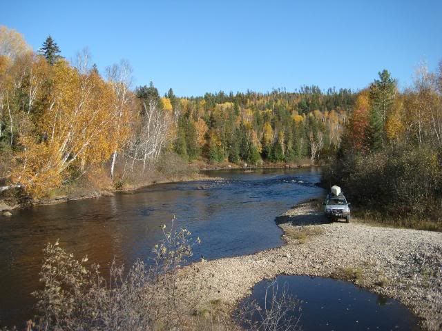
By noon, I'm back at my truck. I was a little worried about leaving it in the woods like that, but everything is in order ... I plan to hit the road around 13:30. So lunch, luggage, attach the canoe on the roof ... A hunter goes by on his ATV. I flag him down for a quick chat. This is when I learn of the existence of the new logging road. I drive it on my way back. I do not think this way is faster, but it's certainly less rough ... but less fun too! You still need a good 4x4 to get all the way to Little Scarecrow Lake ...
Stopping along the Sturgeon River
Crossing a stream

The drive back is uneventful. I hadn't planned on being back as quickly, but I preferred driving the highway before the long weekend (Canadian Thanksgiving) crowds.
To all those who wrote on the Internet of their quest to summit Ishpatina, thank you for the inspiration to make this trip! Obviously, it is getting easier to make this trip.
This text was translated (thanks Google) from my original French account so it might read a little weird...
To plan my trip, I read the various stories on the internet about Ishpatina Ridge. I was traveling solo, approaching by 4x4 as far as I could drive. Then canoe & portage to the trailhead, camp, & hike to the summit.
Some people have done the 4x4 part on bicycle and bushwacked to the Ridge. I was hoping the canoe route would be easier.
I expected a long (3-4 days) and difficult trip. So I planned accordingly. Minimal equipment, but I gave myself ample leeway for stove fuel and food if I had to spend 24 or 48 extra hours in the woods. I also plan for cold and wet weather despite a more than favourable forecast. Mid October temperatures are below freezing at night.
I drive a modified Nissan Xterra 4x4, on 33” BFG, with full recovery gear. On the roof rack, my 15' Kevlar expedition canoe from Swift. My gear is all stowed in a 70litre dry bag.
I leave Ottawa, Friday, October 8, 2010 around 12:30. The roads are not too busy, I drive on the Ottawa River Parkway with stunning views of the Ottawa River. I quickly regain the 417 westbound - Sudbury will be seen in about 7 hours ...
I am surprised by the beautiful scenery. Towns and villages pass by, all household names but never visited: Arnprior, Pembroke, Petawawa, Chalk River. The northern access roads to Algonquin Park surprise me, so many places to visit ... another day perhaps ... I wonder why I'm driving so far when there are many beautiful and interesting places closer to home... But the highest Ontario summit beacons!
North Bay, the shores of Lake Nipissing offer great views of this vast body of water... Sudbury in less than 130km... The sun goes down too fast! But I keep a good cruising speed on the well maintained tarmac of highway 17.
On the outskirts of Sudbury (Intersection Hwy 17 and Hwy 93, in: 46.494286, -80.846715), I fill up the truck and complete my grocery shopping. There is even a LCBO (wine & spirits) and I let myself be tempted by a bottle of wine that I leave in the Xterra to celebrate my success to my return, or drown my sorrow in case of failure !
I then take Hwy 90 north to Capreol, Around 1900hrs, it is getting dark ... Just at the entrance of the village a fox crosses the road and a few seconds later, a black bear! I hope this is a good omen !
I find without much trouble Opy's Central Variety (46.708176, -80.919521) where I stop to purchase my backcountry permits to the Lady Evelyn Smoothwater Provincial Park. The Ridge is in park territory and a permit is necessary for camping. It is also added security (I guess) if I don't make it back out in my allotted time
At Capreol, you can buy gasoline and there is also an LCBO ... 1930h - I drive Portelance road leading towards the shore of Little Sacrecrow Lake...
I'm driving a path that I loaded in my GPS from different sources namely the story of Andrew in 2006 that I have read in my preparations ... (http://alavigne.net/Outdoors/ImageGallery/2006/06-03-IshpatinaRidge/index.jsp?navpage=5) This is where the success or failure of my endeavour can be determined very early on. The dirt track is in pretty good shape, but I am driving in 1st & 2nd gear more than I would like! Many areas are flooded due to beaver activity and crossing water of unknown depth at night (I really need to buy extra lights for the truck!) is nerve-racking !
I surprise a moose that runs in front of my Xterra over a good distance. Whenever I stop to give him a chance to escape in the woods, he also stops. I lose sight of him once, only to realize he's right next to me. We avoid the collision and he resumes his wild run ... I don't want to tire him out as it is hunting season... Finally, he turns into the forest ... I wish him good luck and drive on.
It really takes a good 4x4 to travel this road, a bridge is washed out. The road ends ... I walk a bit to find a narrow path where ATVs have crossed the river. I engage 4low, and drive on. There's always the winch if I can't get across. The water isn't very deep, but the shore is a steep slope. My BFGs do a great job and I am soon on my way again. , many obstacles and two rivers crossed, I get to Little Scarecrow Lake around 22:30. The starry sky is unlike any I have seen in a long time !
23:00, Florin (the dog) and I get settled in the back of the Xterra for the night ...
October 9, 2010, my alarm set for 7:30, sounds ... The nights sleep was restfull. The sunrise promises a super great day. Breakfast time as I organize all my equipment. I plan to start paddling around 09:00. It froze during the night but the sun quickly warms me. I paddle up what I believe to be the discharge of Woods Lake, I portage over a beaver dam, I soon realize that I am wasting time exploring a dead end!
I turn around and find the right path. Here, I make up time getting the canoe upstream of the discharge. I can not paddle, there are only a few inches of water and too much current ... Florin is enjoying the ride as I drag the canoe up the little steam. I am very happy with the hip waders, I bought just for this purpose.
I soon come to a wall of rocks ... I do not see a portage trail, so I ground the canoe in a likely place and proceed to carry my 70 litre dry bag past the rocks. It's a big effort to portage through very dense woods with lots of dead fall. 2nd trip, I carry, I pull, I push and drag the canoe 350 m to Woods Lake... I've wasted a lot of time here ... It's noon and I'm hungry, but I do not want to stop and open my bag to eat. I decide to continue ... I'm hoping to make it to the top of Ishpatina today. So I need to press on.
Woods Lake is quickly traversed, and also the creek that leads to Scarecrow Lake. I'm paddling at an average speed of 5km / h on the lake, I'm encouraged, yet still hungry ... I pass the small island where there's one of the campsites, (47.281107, -80.757194). I can see the tower in the distance ... very far away!
1:00 p.m. arriving at the camp. A little garbage lying around, but otherwise a nice setup. I plan to spend the night here comfortably I hope. I eat my pita, tuna, mayo lunch and I prepare my bag for the hike: water food, warm clothes and sleeping bag for the night in case something goes wrong ...
I find the trailhead fairly easily and follow, marked trees with orange "flag" (ribbon). I make a mental note to turn back by 16.00 if I have not yet arrived at the summit. The sunset is expected around 6:45 p.m. AND I do not want to be surprised by darkness.The trail passes next to three small lakes and swamps and I manage to keep my feet dry - BONUS... Not a single bug to bite me, beautiful fall colours, crisp air ! What a great time of year to be here.
3.5km walked and 1.5 hours later, I see the fire tower on the summit through the branches,
the trail leads me on a few more turns and I come to the base of the abandoned fire tower... The view from the summit is spectacular. I snack, explored, dry off my soaked shirt. I find the two water bottles filled with messages from the people that have been here before me...
Summit view of Scarecrow Lake:
4:00 p.m. comes and goes, it's time to descend. My timings are good! I'll have time to fix dinner and set-up camp before dark.
Back at the camp, 18:30 - unable to pump my stove Peak1 (naphtha) ... The plunger should be lubricated and I do not have oil... In my dry bags I dig, dig, dig ... I find a can of sardines marinated in soy oil ! Thank you Mc Guyver! Soon the stove is heating again! My couscous with wild mushrooms is enhanced with sardines! I also light a camp fire that warms me a little, because the thermometer plummets to below zero quickly. Again, the sky is spectacular, there's no moon so the stars are a show ! the Milky Way clearly visible...
Florin, the dog warming up my sleeping bag:
Spending a night on the top of the ridge with a sky like tonight would be quite an experience ... Perhaps next year?
10 October 0700 - Sunday morning - Florin startles me awake. I listen carefully ... and hear in the lake water, a few steps, then a pause ... a few steps, then a pause ... I hold on to Florin who wants to growl and chase away the intruder. There is barely enough light to see the huge bull moose passing in front of our camp. The wind is in his favour, and he catches a whiff of our presence. H turnes back and trots off into the woods ... Wow! What a beautiful animal! A hunter's dream, he passed by less than 100m from our position!
Morning campsite:
I get up and light a fire. 7:30 I make my oatmeal, and feed Florin. I repack my stuff for the return paddle. I plan to be on the water of a departure around 09:00. I cleanup the campsite and on time, the canoe glides over the water. A breeze from the West slows me down a bit, but what a glorious morning ... I've seen no human since Friday night (hunters on the logging road). I like it like that...
Morning paddle:
This time I find the portage trail from Woods Lake to Little Scarecrow. So much easier than bushwacking with a canoe !
By noon, I'm back at my truck. I was a little worried about leaving it in the woods like that, but everything is in order ... I plan to hit the road around 13:30. So lunch, luggage, attach the canoe on the roof ... A hunter goes by on his ATV. I flag him down for a quick chat. This is when I learn of the existence of the new logging road. I drive it on my way back. I do not think this way is faster, but it's certainly less rough ... but less fun too! You still need a good 4x4 to get all the way to Little Scarecrow Lake ...
Stopping along the Sturgeon River
Crossing a stream
The drive back is uneventful. I hadn't planned on being back as quickly, but I preferred driving the highway before the long weekend (Canadian Thanksgiving) crowds.
To all those who wrote on the Internet of their quest to summit Ishpatina, thank you for the inspiration to make this trip! Obviously, it is getting easier to make this trip.
This text was translated (thanks Google) from my original French account so it might read a little weird...
Last edited:
")