FortyMileDesert
Adventurer
I haven't posted any of my most recent treks here for a while. Here's yesterdays trek; two '04 Discoverys and a '97 and '96 Discovery. Participants from Reno, Carson, Fernley and Gardnerville, Nevada:
- - - - - - - - -
Land Rover Trek 143 (#100 for my ’04 Discovery) 14 March 2009
Some previously visited places and several new trails – Red Ant – Eagleville – La Plata
Up at oh-dark-fifty; the truck was already packed the night before, so just had to fill up the thermos with some fresh coffee. Left the house at about 6:20 and headed towards Fallon with just a hint of pre-dawn glow showing over the Stillwaters. As I approached Jerry’s Restaurant at 6:50, I could see Christopher’s ’04 parked out front. There he was inside looking lonely; just him, a couple old cowboys and the waitresses. Most of Fallon doesn’t fill up Jerry’s until about 8:00.
As the two of us sat there filling up on breakfast we talked about Rovers and off-road trails of course. Well other subjects came up too, but I can’t remember what they were. At about 7:30, through the window we could see Matt in the ’97 XD and Gaelen in the ’96 with four friends (I’ll add their names as soon as Gaelen updates me – I’m old and forget) come rolling into the parking lot.
I paid the bill and we wandered out to make the introductions, check out the rigs and then wait for Eric to show up. About 15 minutes later Chris gets a text message from Eric that he’s not going to make it. We head east, stop at Harmon Junction to top up on fuel, and we’re on our way by about 8:05!
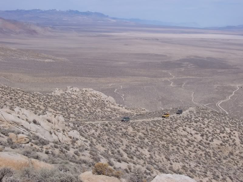
The next thirty miles are on pavement; passing Eight Mile Flat (salt flat), Four Mile Flat (salt flat), Sand Springs (old burnt down brothel), Sand Mountain (where the Californians come to play with their dune buggies), over Sand Springs Pass, turn south at Labou Flat, passing the US Naval Reservation (Top Gun bombing range) and finally turning onto dirt at GZ Canyon (ground zero) and up into the Sand Springs Mountains.
First stop is Project Shoal, a 1968 13kt underground nuclear test site. This is where I get my annual Land Rover under chassis radiation treatment. There must be some reason that I get such great reliability out of my Land Rovers! Not really; this spot is continually monitored and nothing is getting to the surface. Incidentally, ground zero is at a place called Gote Flat at about 5300 feet elevation.
From Project Shoal it’s up the shoulder of Aplite Ridge to what we informally call Little Yosemite, a picturesque granite batholyth outcropping. The two little girls with us are immediately climbing all over mimicking big horn sheep. Then it’s back down to Gote Flat and heading west.
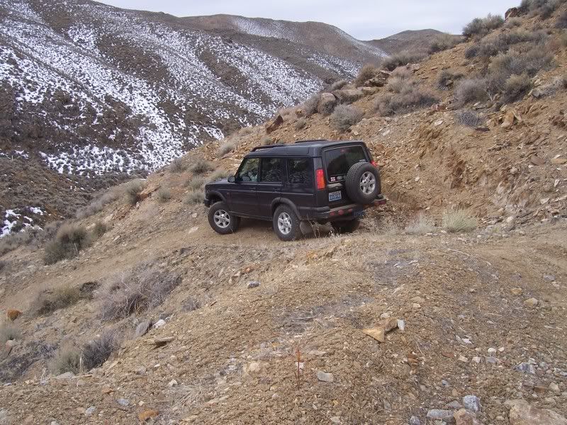
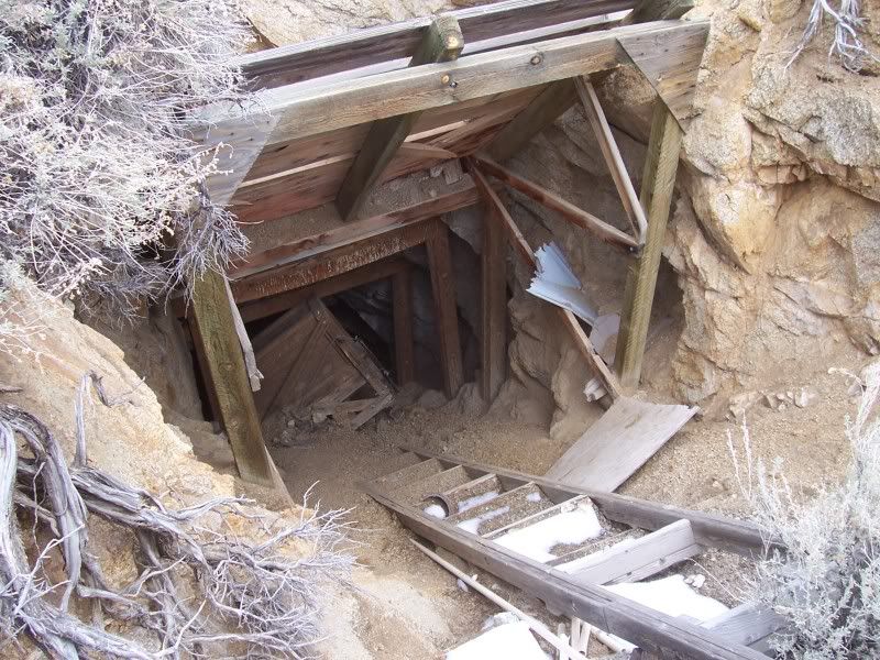
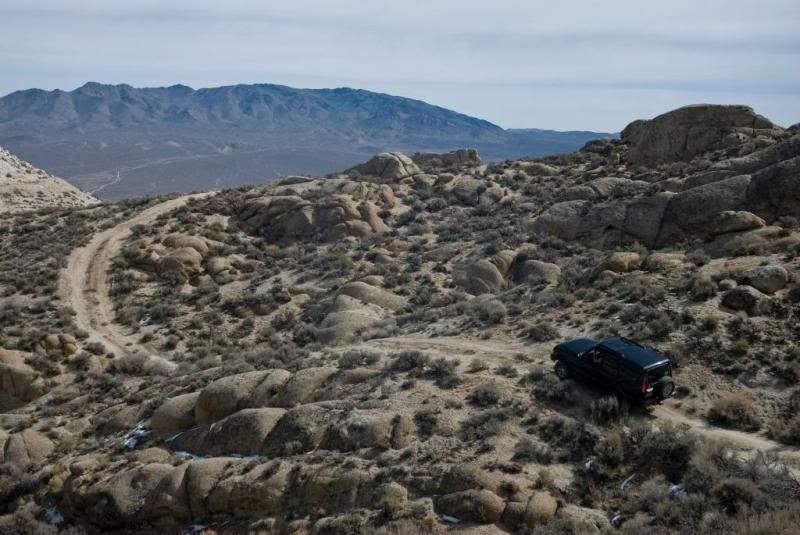
At the western rim of the mountain range, we drop down a shelf road for about 1000 vertical feet and across the sand flats to Wightman Well where we turn south following Four Mile Canyon for about three miles and then it’s east again, climbing back up into the mountains towards the Red Ant Mines. This is the first new trail for me today; there will be more. The trail passes about 100 feet below the head frame and adit of one of the mines and then we make a 180 degree turn about 1500 feet further along and stop at the adit and head frame.
While I’m investigating a trail that drops down a ravine, most of the group investigates the first part of the mine adit. The ravine looks OK so we all crawl down it in the trucks taking lots of photos. Chris learns to trust the HDC.
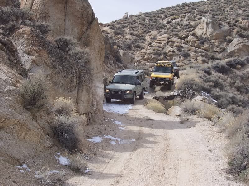
To the east there are a couple of trails that may be passable. The kind of show up on the USGS topos and they were visible on Google. This is another three miles or so of new trail for me; and away we go! After only about 1/3 of a mile we come to a mine. Of course we make another brief stop for pictures before continuing on. Japanese tourists have got nothing on us. After another half mile there is a trail that turns sharply north and crosses over the summit of a ridge at about 6200 feet and drops down to another trail that I was wanting to explore. Out to the east we can see explosions on the bombing range. Of the many times that I’ve been out here, it’s the first time that I’ve seen the navy dropping real bombs!
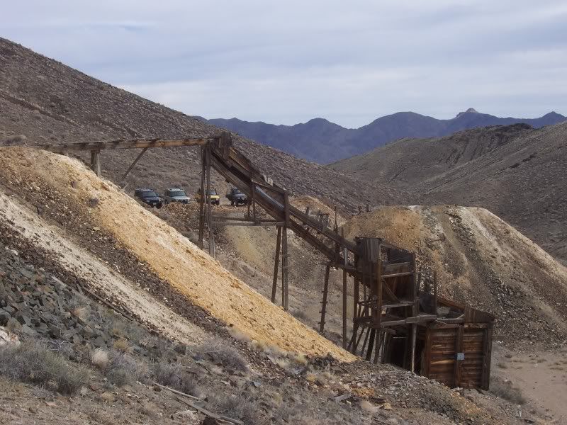
At a small shack we intersect the other trail and then head east for about a mile and stop at another mine. We stop here for a lunch break (yes, it’s already noon!) and some serious investigation. This place is weird. There are lots of wood structures for moving ore around, 50 gallon drums with plastic pipe plumbed to them, a laboratory of some kind and lots of switch panels, transformers, capacitors and heavy duty wiring. It’s probably some kind of small scale chemical ore processing, but a couple of the younger guys are, tongue-in-cheek, guessing “meth lab”.
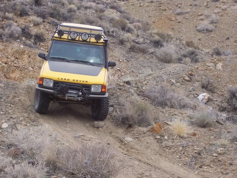
Eventually we finish our lunch and investigations and start down Arterial Canyon towards Fairview Valley. Nearing the bottom of the canyon there is a granite waterfall (dry). In the past, this has been a bit of a challenge when it is just rock. This season the creek has filled sand in around the boulders making it much easier. Everybody gets to play anyhow. We make Chris crawl through the boulders a couple times; we’re training him. He’s also the only one with a totally stock Disco.
Exiting the canyon, we turn south past Lucky Boy Canyon. I’m looking for a trail that should climb steeply for about a 500 foot elevation gain in less than about 1500 feet of horizontal travel. Ahaa! There it is. It looks a bit intimidating. I give it a go as the other three watch me from the bottom. The trail is dry with only a few sandy spots over the granite boulders and I get up to a reasonably flat spot without issue. I stop and take pictures of the others climbing towards me. The view is spectacular.
I can see the trail continuing around the head of a canyon on to a very white peak on top of the granite. I don’t know if the trail continues from there, but worst case we can descend the way we came up. W eventually get to the white peak and I discovery that it is pure white metamorphosed quartz. It appears that it has been mined for decorative landscaping rock. We take another lunch break and investigate. While Tyrone fixes rock cuts with his first aid kit, I look around and find another shelf trail that looks as if it will take us back down to the valley. Yeah, a few people didn’t realize just how sharp the broken quartz slabs were.
The shelf trail is pretty easy going. Evidently this is the way that the people mining the quartz got their truck up here. At one spot there had been a rockslide that narrowed the trail along a sheer vertical rock wall but it was easy to pass with about a foot to spare. Thankfully there was only a little bit of snow to cross.
We head east across the flat again and turn south onto pavement for a few miles. When we get to the summit near Big Kasock Mountain we turn off onto a trail that takes us to a miner’s cabin that the 4wheelnoffroad club had adopted about five years ago. We had spent a whole day cleaning up a lot of trash and hauling out several tons of stuff. It looks as if not much has changed since then.
According to my map there is a jeep trail that should go over a saddle past some mines and then get us into Little Bell Flat valley and then onto Eagleville. The trail is pretty clear up to the saddle and then gets a bit vague. After one wrong turn, I find the trail that is on the map and continue on. This trail has not been used in a long time. It’s primitive just following a bouldery wash for about a mile before arriving at the valley.
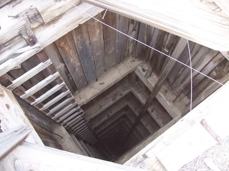
The trail continuing on to Eagleville is very good. It has even been graded. Arriving at Eagleville is a surprise. All of the old buildings are gone! We do climb around investigating a lot of vertical mine shafts and the very rickety ore chute. At about 2:30 I announce that we have accomplished everything that I had planned. Everyone was still willing to do a bit more exploring so I suggested a quick run north to La Plata before calling it a day.
As we head back north along the west side of the bombing range, the girls spot some more bombs going off on the other side of the flat. We stop to watch for a bit. The planes are dropping bombs on some buildings and old tanks on the far side of the valley, perhaps four to five miles from us. It takes about twenty seconds for the sound of the explosions to reach us after we see the smoke.
The trail up La Plata Canyon is very different than when I was here last year with my grandkids. The storms from the past few weeks must have dumped a lot of water. The wash has had a lot of rock and gravel moved around. When we reach La Plata at the intersection of two canyons the roads are unrecognizable; they are just gravelly creek beds. We do a bit of playing around in the creek cut banks. Gaelen gets a bit rambunctious and almost tips his truck over. We tie a strap to his roof rails and three of us pull against it while he gets himself extricated.
At about 4:00 the two Disco 1s decide to head back towards Fallon. Chris and I play around cutting trails in the wash bottom for a bit before leaving. At several points I manage to get both of our trucks momentarily “wheels-in-the-air”. No stucks or damage, not even any pictures! Finally we head towards home.
We pass Harmon Junction at about 5:20 and 146 miles since we had left it. It has been another fine day in the boonies.
- - - - - - - - -
Land Rover Trek 143 (#100 for my ’04 Discovery) 14 March 2009
Some previously visited places and several new trails – Red Ant – Eagleville – La Plata
Up at oh-dark-fifty; the truck was already packed the night before, so just had to fill up the thermos with some fresh coffee. Left the house at about 6:20 and headed towards Fallon with just a hint of pre-dawn glow showing over the Stillwaters. As I approached Jerry’s Restaurant at 6:50, I could see Christopher’s ’04 parked out front. There he was inside looking lonely; just him, a couple old cowboys and the waitresses. Most of Fallon doesn’t fill up Jerry’s until about 8:00.
As the two of us sat there filling up on breakfast we talked about Rovers and off-road trails of course. Well other subjects came up too, but I can’t remember what they were. At about 7:30, through the window we could see Matt in the ’97 XD and Gaelen in the ’96 with four friends (I’ll add their names as soon as Gaelen updates me – I’m old and forget) come rolling into the parking lot.
I paid the bill and we wandered out to make the introductions, check out the rigs and then wait for Eric to show up. About 15 minutes later Chris gets a text message from Eric that he’s not going to make it. We head east, stop at Harmon Junction to top up on fuel, and we’re on our way by about 8:05!
The next thirty miles are on pavement; passing Eight Mile Flat (salt flat), Four Mile Flat (salt flat), Sand Springs (old burnt down brothel), Sand Mountain (where the Californians come to play with their dune buggies), over Sand Springs Pass, turn south at Labou Flat, passing the US Naval Reservation (Top Gun bombing range) and finally turning onto dirt at GZ Canyon (ground zero) and up into the Sand Springs Mountains.
First stop is Project Shoal, a 1968 13kt underground nuclear test site. This is where I get my annual Land Rover under chassis radiation treatment. There must be some reason that I get such great reliability out of my Land Rovers! Not really; this spot is continually monitored and nothing is getting to the surface. Incidentally, ground zero is at a place called Gote Flat at about 5300 feet elevation.
From Project Shoal it’s up the shoulder of Aplite Ridge to what we informally call Little Yosemite, a picturesque granite batholyth outcropping. The two little girls with us are immediately climbing all over mimicking big horn sheep. Then it’s back down to Gote Flat and heading west.
At the western rim of the mountain range, we drop down a shelf road for about 1000 vertical feet and across the sand flats to Wightman Well where we turn south following Four Mile Canyon for about three miles and then it’s east again, climbing back up into the mountains towards the Red Ant Mines. This is the first new trail for me today; there will be more. The trail passes about 100 feet below the head frame and adit of one of the mines and then we make a 180 degree turn about 1500 feet further along and stop at the adit and head frame.
While I’m investigating a trail that drops down a ravine, most of the group investigates the first part of the mine adit. The ravine looks OK so we all crawl down it in the trucks taking lots of photos. Chris learns to trust the HDC.
To the east there are a couple of trails that may be passable. The kind of show up on the USGS topos and they were visible on Google. This is another three miles or so of new trail for me; and away we go! After only about 1/3 of a mile we come to a mine. Of course we make another brief stop for pictures before continuing on. Japanese tourists have got nothing on us. After another half mile there is a trail that turns sharply north and crosses over the summit of a ridge at about 6200 feet and drops down to another trail that I was wanting to explore. Out to the east we can see explosions on the bombing range. Of the many times that I’ve been out here, it’s the first time that I’ve seen the navy dropping real bombs!
At a small shack we intersect the other trail and then head east for about a mile and stop at another mine. We stop here for a lunch break (yes, it’s already noon!) and some serious investigation. This place is weird. There are lots of wood structures for moving ore around, 50 gallon drums with plastic pipe plumbed to them, a laboratory of some kind and lots of switch panels, transformers, capacitors and heavy duty wiring. It’s probably some kind of small scale chemical ore processing, but a couple of the younger guys are, tongue-in-cheek, guessing “meth lab”.
Eventually we finish our lunch and investigations and start down Arterial Canyon towards Fairview Valley. Nearing the bottom of the canyon there is a granite waterfall (dry). In the past, this has been a bit of a challenge when it is just rock. This season the creek has filled sand in around the boulders making it much easier. Everybody gets to play anyhow. We make Chris crawl through the boulders a couple times; we’re training him. He’s also the only one with a totally stock Disco.
Exiting the canyon, we turn south past Lucky Boy Canyon. I’m looking for a trail that should climb steeply for about a 500 foot elevation gain in less than about 1500 feet of horizontal travel. Ahaa! There it is. It looks a bit intimidating. I give it a go as the other three watch me from the bottom. The trail is dry with only a few sandy spots over the granite boulders and I get up to a reasonably flat spot without issue. I stop and take pictures of the others climbing towards me. The view is spectacular.
I can see the trail continuing around the head of a canyon on to a very white peak on top of the granite. I don’t know if the trail continues from there, but worst case we can descend the way we came up. W eventually get to the white peak and I discovery that it is pure white metamorphosed quartz. It appears that it has been mined for decorative landscaping rock. We take another lunch break and investigate. While Tyrone fixes rock cuts with his first aid kit, I look around and find another shelf trail that looks as if it will take us back down to the valley. Yeah, a few people didn’t realize just how sharp the broken quartz slabs were.
The shelf trail is pretty easy going. Evidently this is the way that the people mining the quartz got their truck up here. At one spot there had been a rockslide that narrowed the trail along a sheer vertical rock wall but it was easy to pass with about a foot to spare. Thankfully there was only a little bit of snow to cross.
We head east across the flat again and turn south onto pavement for a few miles. When we get to the summit near Big Kasock Mountain we turn off onto a trail that takes us to a miner’s cabin that the 4wheelnoffroad club had adopted about five years ago. We had spent a whole day cleaning up a lot of trash and hauling out several tons of stuff. It looks as if not much has changed since then.
According to my map there is a jeep trail that should go over a saddle past some mines and then get us into Little Bell Flat valley and then onto Eagleville. The trail is pretty clear up to the saddle and then gets a bit vague. After one wrong turn, I find the trail that is on the map and continue on. This trail has not been used in a long time. It’s primitive just following a bouldery wash for about a mile before arriving at the valley.
The trail continuing on to Eagleville is very good. It has even been graded. Arriving at Eagleville is a surprise. All of the old buildings are gone! We do climb around investigating a lot of vertical mine shafts and the very rickety ore chute. At about 2:30 I announce that we have accomplished everything that I had planned. Everyone was still willing to do a bit more exploring so I suggested a quick run north to La Plata before calling it a day.
As we head back north along the west side of the bombing range, the girls spot some more bombs going off on the other side of the flat. We stop to watch for a bit. The planes are dropping bombs on some buildings and old tanks on the far side of the valley, perhaps four to five miles from us. It takes about twenty seconds for the sound of the explosions to reach us after we see the smoke.
The trail up La Plata Canyon is very different than when I was here last year with my grandkids. The storms from the past few weeks must have dumped a lot of water. The wash has had a lot of rock and gravel moved around. When we reach La Plata at the intersection of two canyons the roads are unrecognizable; they are just gravelly creek beds. We do a bit of playing around in the creek cut banks. Gaelen gets a bit rambunctious and almost tips his truck over. We tie a strap to his roof rails and three of us pull against it while he gets himself extricated.
At about 4:00 the two Disco 1s decide to head back towards Fallon. Chris and I play around cutting trails in the wash bottom for a bit before leaving. At several points I manage to get both of our trucks momentarily “wheels-in-the-air”. No stucks or damage, not even any pictures! Finally we head towards home.
We pass Harmon Junction at about 5:20 and 146 miles since we had left it. It has been another fine day in the boonies.