Retracing Old Footsteps and Making New Ones

ttora4runner

Expedition Leader
Two weeks ago I completed a 4000 mile road trip through Western Colorado, Western Wyoming, Idaho and Washington with a short stop in Utah to visit an old friend and his family, stretched over a two week time period between the 16th of July and the 30th of July (my longest solo trip). The original intent for the trip was to head to the San Juan Islands in Washington to attend a week long training course on rammed earth construction (Sirewall) then spend the next week and work my way back to Colorado. However, due to some schedule concerns with work I had missed the enrollment period and will have to wait till next year to take the course.

Since I already had my vacation scheduled I needed to make new plans and began looking through various trip reports on different forums, past trips I've done and maps of the various states surrounding Colorado to get an idea as to what to do. However, this was easier said than done since I had two weeks off (the longest I've ever had at one time) and one too many ideas floating around my head. Ideas ranged from heading to Denial National Park in Alaska, the east coast an area I've never been and heading up thought Vermont, New Hampshire and Maine, driving to Banff Canada and Glacier NP to staying in Colorado and hiking as many 14ers as I could. These were just some of the ideas I had floating around.

In the end I decided to retrace some old footsteps in places I hadn't been in over twenty years to some of the more recent places I've been and to making some new footsteps in places I hadn't been. The plan was to head to Ouray, Colorado via Scofield Pass and to hike Uncompahgre Peak, explore around Engineer Pass (driven it a few times) and to hike some other trails in area that I've seen from past trips. Then up to Grand Teton National Park through the backcountry of central Idaho on my way to Mt. Rainer National Park ending up in Olympic National Park and the pacific coast.

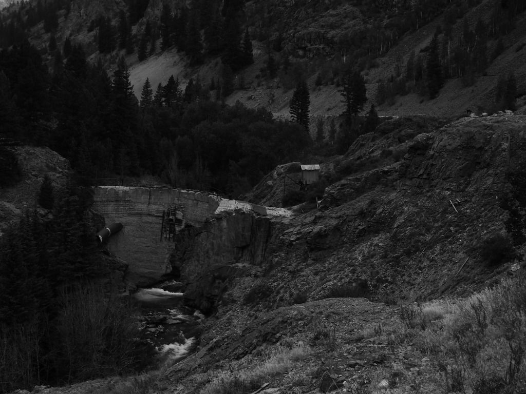
July 16th – My plan for the day was to head to Ouray, Colorado to set up camp and to check out the conditions of Uncompahgre Peak but not before taking a detour through Scofield Pass and the Devils Punch Bowel to check out Crystal Mill. Yet, it was not to be. When I reached Gunnison I was greeted by a parade/celebration that closed down the main road through town and detouring you though another part. Unfortunately, the road I need to take to get to Crested Butte was one of the roads blocked by parade. After some fumbling around town and looking at my map I was back on track. Along, the way to Crested Butte I kept passing or being passed by Jeeps and UTV traffic which I was assuming was heading to the same area that I was. Seeing this amount traffic made me think twice about heading to Scofield Pass and just outside of Crested Butte I made the decision to turn around and just head to Ouray. I really didn't feel like dealing with this amount of traffic on the trail.

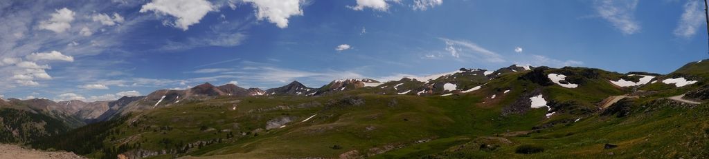
Since I was planning to hike the following day I took the indirect route and head to Lake City and after fueling up I started up Engineers Pass to Nellie Creek (an area you really don't read much about) which leads to the trail head of Uncompahgre Peak and then on to Ouray.


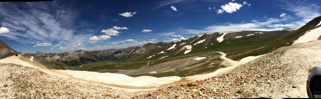
Nellie Creek trail isn't that difficult of a trail and dead ends at Uncompahrge Peak trail, the trail is CUV's capable when it's dry.Upon reaching the end of the road and the hiking trailhead I spoke with a couple that had just came back down and learned that the trail to the top was clear with no snow, a good sign.

Once I found out the trail was good I headed back down the trail to finish taking Engineers Pass over to Ouray and my campsite at the KOA.


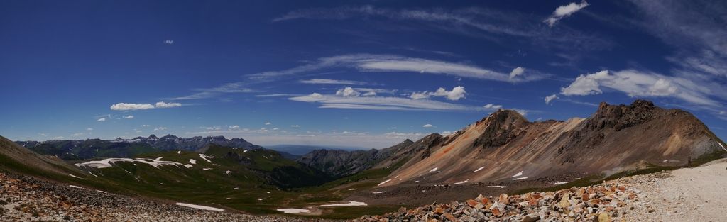
The summit of Engineers Pass.


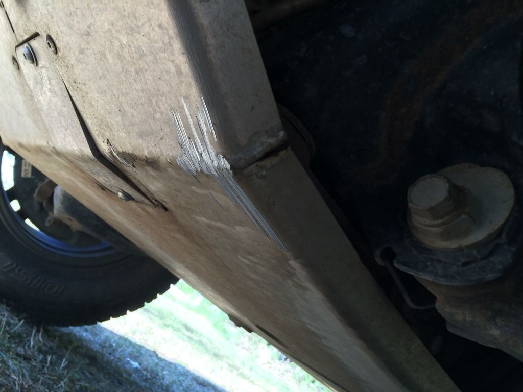
Coming around one of the narrow turns somewhere along the way my front skid plate got into a fight with a rock and lost.


Last edited:

ttora4runner

Expedition Leader
July 17th – Having just driven Engineer Pass the day before I really didn't feel like taking the trail back over to Uncompahgre Peak and opted to back track a little to Lake City then back up Engineer Pass to Nellie Creek and to the trailhead.

The peak in the background is where I would end up.


Somewhere along the way I ran into a group who were hauling musical instruments up the trail, one guy was hauling a bass and they looked beat. I was assuming they wanted to make it to the peak to play but they never did reach the summit and there was no sign of them when I came back down.

Somewhere up their was my destination.


Almost to the summit.


The view from the summit.


Various flowers along the trail


Coming back down the pass near the North Fork Cutoff I spotted massive herd of sheep crossing though the valley below. I've seen large group of sheep before being herded but nothing like this. When I reached the intersection of the Engineer Pass and the North Fork Cutoff I decided to head to Silverton along a route I hadn't traveled before.


Animas Fork


An old cabin and waterfall.


The remains of Sunnyside Mill


On the way back I made a quick detour and headed over to the Yankee Girl Mine area. Every time I've come to Ouray I kept telling myself that I'd make the trip over but for one reason or another I just never made it. So I made it a point to stop and check it out.


ttora4runner

Expedition Leader
July 18th - Last year I had hiked to the saddle of Mt. Sneffels but due to some physical problems I had been having opted out of making the final ascent to the summit. Since I was back in the area I wanted to give the hike another ago. Unfortunately, the weather was really optimal to make the hike and I decided to head back down and hit up another trail I’ve seen multiple times before but never took the time to hike.


Since the weather wasn't favorable up at Mt. Sneffels I opted to head up Bear Creek trail to Grizzly Bear Mine and Yellow Jacket mine. Just out of Ouray off of the Million Dollar Highway.

Bear Creek Trail


I passed an older gentleman along this section of trail and he had mention that I had just missed the rainstorm and wind that just blew though. I’m grateful that I did.


Grizzly Bear Mine. Right near the ruins there and old vertical shaft that was been grated up and locked and shortly there-after another mine that looks like the gate had been ripped off.


The remains of Yellow Jacket Mine area.


Had I decided to keep going on the trail it would’ve taken me up to Engineer Pass but I had other plans that day so I turned around and headed back to my car to grab lunch then on to the next stop.
My last stop for the day was the Bandora Mine and Clear Creek Trail just outside of Silverton. Having now driven this trail it’s nothing special but would make for a good back country camp site.


Having dink around the Bandora Mine area I headed on back to camp to relax from the days hike, grab dinner and take a nice hot shower. Early in the evening it had rained for about 15-20 minutes then let up and the sun came back out to dry up the area a little. Since I was going to have an early morning the next day to start the next part of my trip I opted to pack up my tent (once it dried out)and just sleep in the back seat of my car. I didn’t feel like dealing with a potentially wet tent in the morning if it rained again. Sometime around 900 pm the sky let loose again and started raining again. I figured it was time then to hit the hay. That storm would last around an hour then sometime in the middle of the night it would rain again. I’m grateful I made the decision to backup and sleep in my car.
 

ttora4runner

Expedition Leader
July 19th –

This day was mostly uneventfully as I traversed western Colorado into Rock Springs, Wyoming and into Alpine, Wyoming.

Somewhere between Colorado and Wyoming.


Now when I say mostly uneventful two things happened this day that kind of threw me off and got me frustrated. Somewhere outside of Rock Springs that was a construction billboard that noted the road north of Daniels Wyoming was closed. Didn't give a reason why just said close and I figured maybe because of construction and I was hoping that's all it was.
Well, unfortunately that wasn't case as there was a forest fire between Daniels and the Hoback, Wyoming area (hwy 189/191 to the junction of hwy 89). So people were being turned around and told to head to Kemmerer, Wyoming then north again up hwy 89 to reach Jackson.

Secondly, somewhere between Afton and Alpine, Wyoming power had gone out to the region so stores, gas stations, hotels, etc where shut down and to top it off cell phone service was next to nothing (Verizon, personal and AT&T, work). Due to the delay earlier in the day the campsite(s) I was hoping to stay at around Grand Teton National Park where filled up and since I didn't have my Wyoming map nor a working cell phone I started to getting stressed out.

Fortunately, I was able to get somewhat of a good reception on my Verizon phone and called my older brother in Arizona and he was able to give me some directions to a campground around Palisades Reservoir. Once I got camp setup I was able to relax and take a breather.

One note to myself is to make sure to take my paper map with me while passing through a state and not count on having cell phone service.
 
Last edited:

ttora4runner

Expedition Leader
July 20th – Wednesday morning I worked my way over to Grand Teton National Park. I hadn’t been to this area in roughly 10 years when I was going to college in Rexburg, Idaho. I decided before heading up to Colter Bay campground I’d make the drive along River Road to check it out.


Elk off the side of the road


After completing the River Road I worked my way up to Colter Bay to get a campground for the night and then head back out to hike String and Leigh Lake trails up to Bearpaw Lake.


Bearpaw Lake I didn’t find it to be anything special just bug infested and overgrown. If I do come back to this area I would like to rent a kayak to canoe to check out the lakes and to camp along the shore.
Wednesday night I attended one of the ranger programs on bear/wolves in Yellowstone all the while being attacked by bugs.
 

ttora4runner

Expedition Leader
July 21st – Thursday morning I worked way over to Lupine Meadows area to hike up to Garnet Canyon area. The trail isn’t overly difficult till you reach the upper portion of the canyon where you cross a small boulder field to get into the canyon. You have some great views of the glaciers in the area.


Can you spot the two skiers coming down the glacier?


The upper portion of the trail I opted to stop and turn around since the ascent up to the saddle between the two peaks (don’t know the names) was still snow covered and I really didn’t feel like trying to traverse a snow field.


The hike back down was uneventful but a lot more people had started the hike up the trail.

Kind of a funny moment, at least I think it was. On my way back to camp I stop at one of the turnouts to grab lunch and right when I get down making lunch and closing the back of my car an Asian tour group pulled up and piled out like a group of Sardines to take photos of the Tetons (reminded me of a Sponge Bob Squarepants episode). One of the tourist got a little to close to my vehicle and when I went to back up my front end made a loud popping/clunking noise (aftermath of Engineers Pass) that startled the individual. I had a big grin on my face when they looked back at me. Couldn’t help myself.

The rest of the day was pretty uneventful just did laundry and took a shower after a couple of days of not doing so. Colter Bay Village has the only shower and laundry facilities in the park (reason why I chose it).
 

mph

Expedition Leader
Ahhh...Looks like a grand trip. The Tetons are fabulous. The snowfields are treacherous but so much faster traveling over in the summer. Looking forward to more pics...
 

ttora4runner

Expedition Leader
July 22nd – Thursday morning I headed early out to start the next portion of my trip over to the Rocky Bar/Atlantic City area in Idaho.

My final view of Grand Teton National Park, I’m not complaining.


The drive along hwy 20 in Idaho had to be one of the top boring drives I would take on this trip and I opted to take a dirt road towards the turn off for Anderson Ranch Reservoir just to change things up.
Rocky Bar area.


I had originally planned to head up to either Atlanta or to the Trinity Lake area to camp for the night but since I had the clunking noise I didn’t feel like venturing further into the back country encase I ran into an issue so I opted to head back to Mountain Home and grab a hotel for the night.

Heading back to Hwy 20 I spotted a truck and camper who had gotten to close to a reservoir and sank the front end of their trunk into the sand. I decided to try and give the folks a hand and try to pull their truck out. Despite them unhooking their camper and digging out in front of their truck they kept sinking deeper into sand. It ended up taking someone in a backhoe to pull them out. Apparently, the guy does it on a regular basis for people who get too close to water and sink their vehicles.
It was nice to spend the night in a hotel and not in a tent especially when you start to shake and sweat from not taking a break for lunch and driving all drive.

July 23rd – Friday, drove from Mountain Home to Yakima, Washington for another stay in a hotel and to restock on supplies. This was a planned stop.
 

ttora4runner

Expedition Leader
July 24th – Saturday, started the last major portion of my trip as I headed over to Mount Rainer National Park to hike around for the next two days before heading elsewhere. The last time I was in this area was on a family vacation some 20+ years ago as a little kid so seeing this area again was a welcome site.


Before heading out to start exploring the park I stopped by La Wis Wis campground to check it out since I couldn’t check in till 400 pm and the Ohanapecosh Visitor Center. I swear that neither one of these places have been updated in twenty years. Both just seemed run down and in need of some TLC.

After checking both areas out I headed up to the Paradise Area to hike the Skyline Trail and then Pinnacle Peak Trail. I’ll say this much if you want a decent parking spot up in the Paradise area get there early because parking is limited and you’ll have to park along the road. Parking here reminded me of the parking issue at Glacier National Park up at the visitor center on of the Going to the Sun road.
Skyline Trail – trail was packed with hikers, groups back packing to the summit, skiers and back country training groups.


Waterfall.


Somewhere along the trail.


Groups hiking up the snowy mountain.


Up at Panorama Point


While up at the point I heard a loud boom/crashing noise and turned around to see a small landslide up along one of the ridges.


Paradise Glacier


Pinnacle Peak Trail area.

View of Mount Rainier from Pinnacle Peak trail.


Me, I’m a dork.


Pinnacle Peak trail continue past this point in two different direction which will take you up to the various peaks in area. I decided not to venture any further and headed back to camp.
 

ttora4runner

Expedition Leader
July 25th – Sunday, morning I headed up to the Sunrise area at the northern part of the park to hike the 1st and 2nd Burrough trails, Mt. Freemont Overlook and Sourdough Ridge to Dege Peak. The nice part about this area was that is was less busy than the Paradise so hiking was a bit more enjoyable.

Mount Rainer from the Sunrise Area


Heading towards Frozen Lake


Frozen Lake, well not so frozen.


Along Burrough trails, there were short sections of trail that were still covered with snow that you had to cross. Going up wasn’t so bad coming back down was a little sketchy it started to hit up and get a little slushy.


View from the 1st Burrough


Close up from 2nd Burrough of a portion of the mountain that interested me.


Mt. Freemont Overlook, the fire watch tower was a magnet for bugs.


View of mountain from the overlook.


Somewhere along the way from Dege Peak I kind of puttered out but I started thinking of for going the part of my trip to Olymipic National Park and just head for home. That night I camp I made the decision to come home. I think I just burnt myself.

I would spend the next two days traveling home with a stay in Ogden, Utah to visit with an old friend and his family.

July 28th – Thursday, did absolutely nothing. It was great.
 

ttora4runner

Expedition Leader
July 29th – Friday, since I came home a little early and since I started this trip with a hike to 14,000’ I figured what better way to end my vacation with hiking the highest peak in Colorado and the 2nd highest in the lower 48 states, Mt. Elbert. 14,433’ of fun.

Along the trail.


Out of the tree line, this is where I started seeing a number of groups making the same journey to the top. So I wasn’t the only crazy one.


Looking back down the trail at those whom where traveling up.


View from the top.


And the dork once again.


Overall, I can’t really complain about this trip. It was great to get out and explore old and new areas and too meet some interesting folks along the way.
A couple of minor things I took away from this trip.

If you want to tick someone off in Oregon just ask a gas station attendant why you can't pump you own gas. It’s surprising how an innocent question really set them off.

I hate buying ice. It was annoying.

If I do a trip like this again I’d want to go with a group. Even though I’m not a big group person it would’ve been nice to have some company.

I didn’t make one single campfire the entire trip.
 

NMBruce

Adventurer
nice write up. love your pictures, sounds and looks like a great trip

The sheep on Engineer Pass, get moved around every year or there might be 2 groups. Lots of times you will see a tent and a horse out there
 

ttora4runner

Expedition Leader
nice write up. love your pictures, sounds and looks like a great trip

The sheep on Engineer Pass, get moved around every year or there might be 2 groups. Lots of times you will see a tent and a horse out there

Thanks.

There's was actually a small trail out there.
 

Forum statistics

Threads
189,893
Messages
2,921,914
Members
233,083
Latest member
Off Road Vagabond

Members online

Top