2020 Gaia Topo Map

Howard70

Adventurer
Fellow Wanders:

Gaia has recently released a new version of their Gaia Topo map layer. I've spent a little time with it on my iOS devices and Windows computer (via GoogleChrome). If you're interested, visit this link which explains access. Apparently it is available for Android users willing to work within Gaia's beta versions.

From a quick look it appears to address several of my frustrations with the previous version:

1. Much better display of available roads at broader views. The older map used to drop roads as you zoomed out while this one retains roads so you can more easily get an idea of how to get between distant places.

2. Same for topographic features and contour lines. Much greater detail at landscape scales for surveying broad swaths of country.

3. Vector based rather than raster based. While not completely new as recent versions were also vector-based within the iOS world, if you're interested in beta Android Gaia you can get the vector as well.

I haven't looked in detail at trails and two-tracks so I don't know if the coverage has changed or not.

Take a look!

Howard
 

Superduty

Adventurer
I joined their beta program for Android. Android has been seriously lacking for Gaia. I'm hoping this major makeover fixes a lot of the problems on Android.

Sent from my SM-G973U using Tapatalk
 

moose545

Active member
As a former satellite imagery guy, Vector vs Raster is a HUGE difference, that alone is a major performance changer. Vector will render and draw much faster, and uses a fraction of disk space comparatively for the same sized AOI/area.
 

Howard70

Adventurer
Is the current Gaia for iOS vector or raster

The previous "current" version was vector in iOS. The new 2020 Gaia Topo is also vector but with different content as explained at thislink.

Is this another layer that I need to upgrade or ?

This link explains how to access the map and whether upgrades are required. If you want any map as part of a multilayer configuration I think you need to have a premium membership.
 

outback97

Adventurer
...
From a quick look it appears to address several of my frustrations with the previous version:

1. Much better display of available roads at broader views. The older map used to drop roads as you zoomed out while this one retains roads so you can more easily get an idea of how to get between distant places.

2. Same for topographic features and contour lines. Much greater detail at landscape scales for surveying broad swaths of country.

3. Vector based rather than raster based. While not completely new as recent versions were also vector-based within the iOS world, if you're interested in beta Android Gaia you can get the vector as well.

...

We were planning a day trip this weekend so I downloaded the new app and was excited to try it out. So far I have to say I'm not really seeing improvements in 1 and 2 that you mentioned above. I should say that I have not used Gaia GPS that extensively, so it's quite possible I'm doing something wrong, but it's certainly not the first time I had used it. I have a legacy account from when you could buy the standalone app, before they went to the subscription model. I don't know if that makes any difference in my comparison.

One thing that was odd was that it didn't replace my old app on either my iphone or the ipad mini. The nice thing about that was that it allowed me to compare the two.

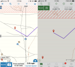
I took a screen shot of the area we visited this weekend at a similar zoom level (you can't see the zoom level anymore with the new app) and the left panel shows the old app versus the right panel being the new one. The difference in detail is quite noticeable. As I zoom the new one in so that the scale reads 2000 feet, more details emerge. I guess I was hoping that these roads would show up without having to zoom in so far.

gaia-gps-old-new.png

Granted these are not major roads, but that's the point of an app like this. Here's the two track that we were on.

4itRqdxHHXkeHt-LYy3lbQJ5hQidfy5QTrTTIFV85-ZHoK1yy3VgZm9IGy6giL6REWtcDGAs3OH9499urvZClMjBWvvNmPnKXOAUe3OPeGumutVoLYb5N1hwOSwQZuo3ZmgTQ-8Thi8=w2400


I'm interested to hear about what other people think about the new version after using it in the field. I really like the app, both versions, but from the little I've used it I'm not yet sold on the new one.
 
Last edited:

Howard70

Adventurer
Hello Outback97:

There are a couple of possibly confusing factors. There are two new components - app versions and Gaia Topo Map versions. The app is how you see and the map is what you see. As I understand it, there are three means of seeing (apps) that might let you see the 2020 Gaia Topo map - www.gaiagps.com, Gaia GPS iOS version 2020.2 and the most recent beta version of Gaia GPS for Android.

I think that using www.gaiagps.com you will only see the new Gaia Topo map (if you have selected Gaia Topo as the layer to display), I don't think the old version of the Gaia Topo map is available there. When using either iOS or beta Android what you see may depend upon what was downloaded or updated. In other words you could have updated the app, but still have the old map downloaded and thus even with the new app you'd see the old map.

From the comparison image you posted, it looks like the new app on your machine might not be displaying the 2020 Gaia Topo map. I agree with you about missing the zoom level indication!

If you'd like, I could post an image of what the 2020 Gaia Topo map would display for a similar screen image of the same area. I'd need the lat/long of that spot to get comparable coverage.

Howard
 

outback97

Adventurer
Hello Outback97:

There are a couple of possibly confusing factors. There are two new components - app versions and Gaia Topo Map versions. The app is how you see and the map is what you see. As I understand it, there are three means of seeing (apps) that might let you see the 2020 Gaia Topo map - www.gaiagps.com, Gaia GPS iOS version 2020.2 and the most recent beta version of Gaia GPS for Android.

I think that using www.gaiagps.com you will only see the new Gaia Topo map (if you have selected Gaia Topo as the layer to display), I don't think the old version of the Gaia Topo map is available there. When using either iOS or beta Android what you see may depend upon what was downloaded or updated. In other words you could have updated the app, but still have the old map downloaded and thus even with the new app you'd see the old map.

From the comparison image you posted, it looks like the new app on your machine might not be displaying the 2020 Gaia Topo map. I agree with you about missing the zoom level indication!

If you'd like, I could post an image of what the 2020 Gaia Topo map would display for a similar screen image of the same area. I'd need the lat/long of that spot to get comparable coverage.

Howard

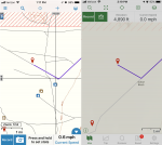
Thanks for the reply Howard. I added "iphone" to my original post for clarity. The right panel of the screenshots are taken from an iphone 8 running v 2020.2, and I downloaded the maps after installing the new app on Friday 1/31. I think the maps were downloaded the next day, on 2/1, so I assumed they were the new upgraded maps. I just now have tried deleting and re-downloading the map for this area, and it does appear to be a bit different. Here's my new comparison.

gaia-gps-old-new2.png


There is more detail in the topography at the very top of the screen on the right panel. There is an addition of the name of the wash, and the main road (running at a 45 degree angle from lower left to upper right) is now visible at this zoom level. So this must be the improved map, and it is better than the old one, but still doesn't show as much information as the old app at a given zoom level, pictured on the left panel again above.

I tried viewing this area on gaiagps.com and of course it does show a lot more because of the much larger screen on my PC. But other than occasionally planning a trip, I don't really use the website that much since it's not what I have on hand in the field.

Thanks for the suggestion about verifying that I had the newest map. I'm not sure why the one I downloaded this weekend wasn't the newest. And I need to get out and use the new version some more so I can better learn how it works.
 

Howard70

Adventurer
Hello Outback97:

Thanks for the newer comparison. The right panel still doesn't look completely correct for the newer map - at least compared to areas I used for comparison when I had access to both versions.

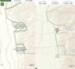
Here is a comparison with the old map on the left (from my iPhone) and the new map on the right (from iPad but sized to compare as best I could). I have had some problems getting the new map to download completely at the full resolutions on the phone and the ipad. I assumed it was because a lot of downloads were occurring as lots of folks might have been doing the updates and downloads. In fact my iPhone shouldn't be displaying the old map! I suspect it is a cache issue - the old map is probably in the cache which I hadn't cleared when I did the comparison!

IMG_1306.jpg

I agree that the www.gaiagps.com means of viewing will show a larger area due to the bigger screen, However if you watch the scale and have the same scale on the map displayed by the app on your phone and the map displayed on gaiagps.com the detail displayed should be the same if the map on your phone is the same as the map on the web version. I think that any differences in the detail (not the area displayed) would likely be due to an imperfect version of the map being downloaded to the phone. Does that make any sense?

Howard
 

Howard70

Adventurer
Hello Outback97:

Well, it took some sleuthing, but I think I found your area. Below is a screen shot from my iPad with the new Gaia Topo map sized as best I could to match the image from your phone. This is at the same scale as your image. It shows quite a bit more detail than the image you recorded from your phone, even though both are at the 1 mile scale.
IMG_1308.jpg

I think there could be two possible reasons:

0. My iPad is better than your iPhone! Joking - scratch this one....

1. Your download was incomplete due to some glitch at the Gaia end of things. Entirely possible.

2. I was able to get the display on my iPad to match the image on your phone by zooming out just a tad - not enough to change the scale but enough to drop some detail. Thus I wonder if your download was at full resolution (zoom level 14 for the vector maps)?

Anyway, thanks for the geo-sleuthing challenge!

Howard
 

outback97

Adventurer
Yes that’s the area. I tried the same comparison on my iPad mini, and it’s better on the new version of the app. Not sure why the phone isn’t. I’ll have to play around with it some more.
 
I don’t know about the old Gaia but I just got a new iPhone with 512 gig and opted for the pro level subscription. For 5 years! Totally stoked. After all this time I found something that works. I was able to easily download most of Big Sur the western Sierra nevadas and the inyos with plenty of space and pretty quick too. I added some random way points for the San Andreas fault where it crosses i5 in Gorman and also for where the garlicky fault crosses the San Andreas just to play. So it really works well for me!
 

roving1

Well-known member
The Gaia topo layer still absolutely sucks for having road names. I use the US topo layer the most because it has most names. Sometimes locals or forum guys refer to everything by the text name of the road instead of the number designation. Sometimes you are trying to stay on a certain name of road but the sign is missing. It's great to have every topo contour of an area but that info is not as useful as the road name.

I really wish one of the topo maps would just have major roads and cities when zoomed out to 50 miles+-. To figure out what cities and major roads are in the area I usually have to switch to Google maps or a different gaia layer like landscape. Be nice to have both in one map layer.Screenshot_20200213-220547_Gaia GPS.jpgScreenshot_20200213-220525_Gaia GPS.jpg
 

Forum statistics

Threads
188,314
Messages
2,905,324
Members
229,959
Latest member
bdpkauai
Top