Cabrito
I come in Peace
I love it. Why did I wait so long?
Although I have yet to do anything advanced I thought I would share a little bit that I have done so far. I would consider myself to be a real basic user and will probably never really use this thing to its full potential.
So out with the old in with the new.
I’ve been using an old Garmin GPS 12 for years and have been quite satisfied with it.

It does not do maps but it does leave a bread crumb trail to follow home. It also interfaces with my laptop and mapping software really well.

I almost think I can ditch the laptop setup now.
The Nuvi 500 has three settings, driving, bike, and hiking. It auto-senses between hiking and driving. It’s waterproof, and it seems pretty rugged but I would still be carful with it. It’s pretty heavy compared to a similar sized Magellen, one of the cheap ones you get a Costco that is streets only. For some reason that says “quality” to me. The price is right to if you can find it on sale. I’ve seen it for as low as $223 at my local BestBuy. I paid a little more on Amazon, . (note to self: drop by bestbuy before purchasing online)
It lets you take screen shots and leaves a trail of where you traveled making it easy to find your way back.

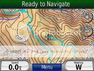
We used it while hiking in Boggs Forest near our place in Lake County. The hike takes you through pretty thick forest so understandably the gps has a hard time keeping up.

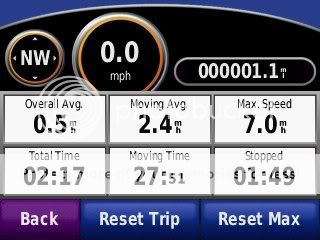
Because of the thick cover of the trees the trip meter was not even close to accurate.

Out in the open this thing would really rock. It did a way better job than the old GPS 12 ever does. This was evident by the bread crumb trail that it leaves for you.

We hiked for over two hours and the battery held up really well considering that I was constantly playing with it. Plus it was probably working really hard to try and connect with the satellites.
Here is a screen shot of the battery usage,

Here are a few more screen shots


I can’t wait to use this thing on our Death Valley trip next month. It lets you input way points and I have already put a few destinations, and checked it out on the pre-installed topo maps.
I’m sort of an analog person living in a digital world so I am easily impressed.
Although I have yet to do anything advanced I thought I would share a little bit that I have done so far. I would consider myself to be a real basic user and will probably never really use this thing to its full potential.
So out with the old in with the new.
I’ve been using an old Garmin GPS 12 for years and have been quite satisfied with it.

It does not do maps but it does leave a bread crumb trail to follow home. It also interfaces with my laptop and mapping software really well.

I almost think I can ditch the laptop setup now.
The Nuvi 500 has three settings, driving, bike, and hiking. It auto-senses between hiking and driving. It’s waterproof, and it seems pretty rugged but I would still be carful with it. It’s pretty heavy compared to a similar sized Magellen, one of the cheap ones you get a Costco that is streets only. For some reason that says “quality” to me. The price is right to if you can find it on sale. I’ve seen it for as low as $223 at my local BestBuy. I paid a little more on Amazon,
It lets you take screen shots and leaves a trail of where you traveled making it easy to find your way back.

We used it while hiking in Boggs Forest near our place in Lake County. The hike takes you through pretty thick forest so understandably the gps has a hard time keeping up.

Because of the thick cover of the trees the trip meter was not even close to accurate.

Out in the open this thing would really rock. It did a way better job than the old GPS 12 ever does. This was evident by the bread crumb trail that it leaves for you.

We hiked for over two hours and the battery held up really well considering that I was constantly playing with it. Plus it was probably working really hard to try and connect with the satellites.
Here is a screen shot of the battery usage,

Here are a few more screen shots


I can’t wait to use this thing on our Death Valley trip next month. It lets you input way points and I have already put a few destinations, and checked it out on the pre-installed topo maps.
I’m sort of an analog person living in a digital world so I am easily impressed.


