FortyMileDesert
Adventurer
Land Rover Trek 131 – 12 November 2008
Searching for the Desert Queen Mines
It’s a beautiful day and a good excuse to get out and play. All of the packing, hauling, loading and unloading, super-cleaning the Rocklin house has worn me out. Playtime!
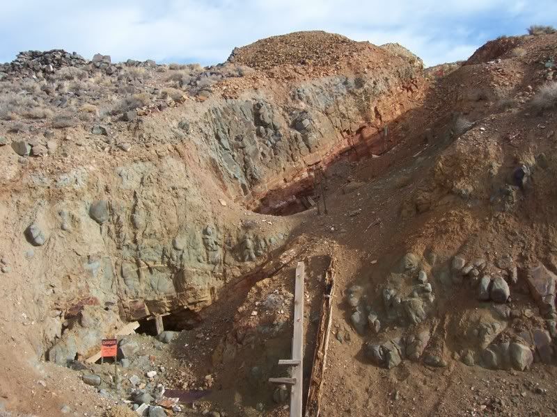
Today we’ll be exploring in the north end of the Hot Springs Mountains. I’ve taken you there before to Cinnabar Hill, the Fallon-Eagle Mines and the Desert Queen Mines. This time though, I intend to find a lot more shafts and adits that are supposed to be on the other side of the hill from the mines at the foot of the hills at the White Plains.
I leave the house and drive on pavement on US50 Alt to downtown Fernley and then east on I-80 to Bradys Hot Springs for a total of 25 miles. From now on it will be dirt all the way back to the house via the mountain range.
I head north-east for about four miles and then south-east. I try a few side trails that go towards the interior of the range. One is marked on the map and three are not. All eventually peter out and I have to return to the main trail. One of them, in fact, ends so abruptly at a cliff that I have to back down a steep incline. I hate doing that!
Eventually I enter the valley that flows for about five miles from Desert Peak towards White Plains in a northerly direction. I’ll be exploring the west side of Cinnabar Hill and the un-named hills that contain the Fallon-Eagle and Desert Queen Mines.
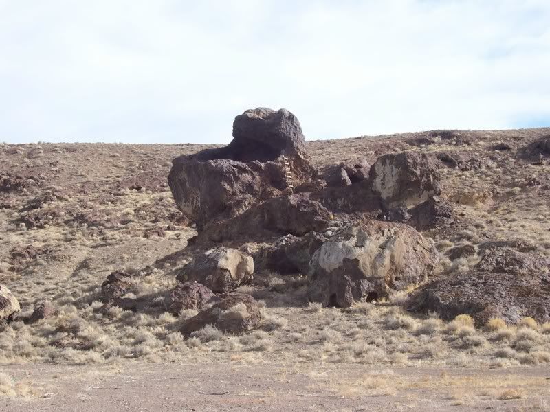
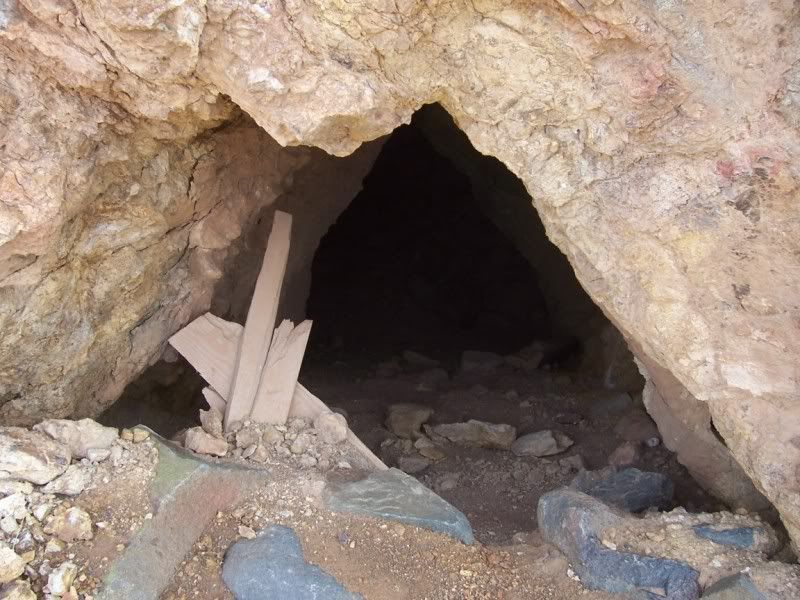
Near the strange little butte with all of the caves there are about a dozen short trails to explore. I think that the caves in the butte are probably archaeological sites although I have not found any references to that.
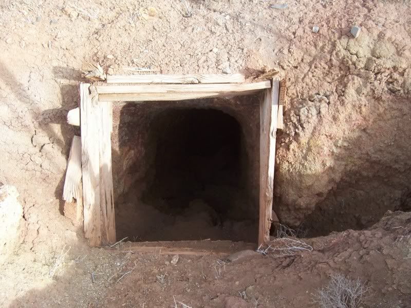
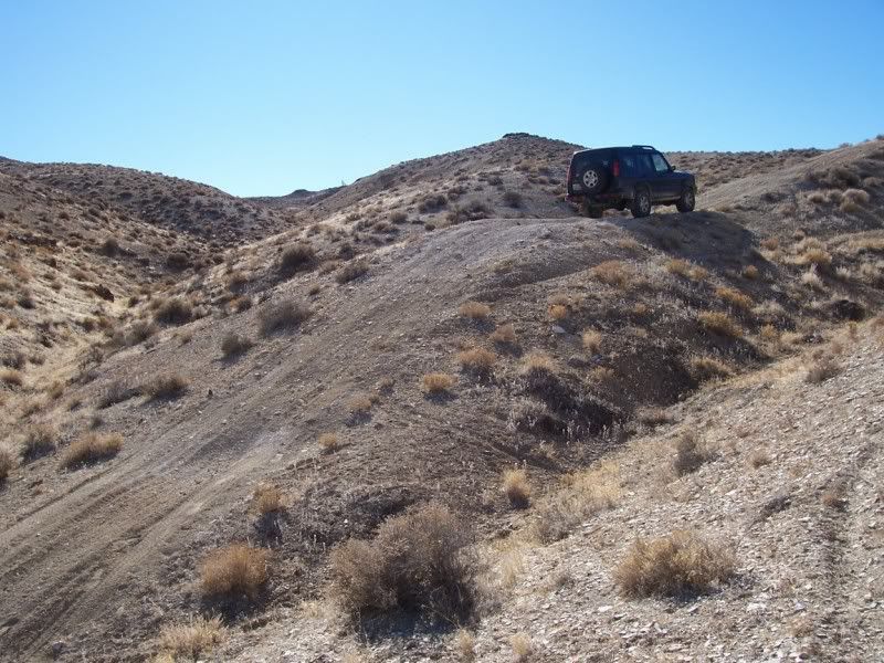
Pretty soon I turn east onto a long trail that according to the maps goes all the way to the pass between Desert Peak and Green Hill. Just a few hundred yards up this trail and I find an un-mapped trail that appears to head towards where I believe the Desert Queen Mine main workings are. For about a half mile the trail climbs to a saddle. From the top of the saddle I can see my destination.
The trail on the other side of the saddle is a mess. There are several old mine roads in various conditions. These trails go from bad to terrible to just ending at washed out ravines. For the next two hours I explore every passable trail that I can navigate. The whole time I have the CDL locked and still the traction control is doing its thing.
According to the map there should be a 4wd trail down a canyon on the south side that will take me back out to White Plains. I find it but its not something I want to try today alone. I’ll come back with partners at a later day. It looks like it should be fun though.
From the mines I retrace my route back to the Cinnabar Hill Canyon and then drive the pole line road back to Fernley. The run today has been 66 miles of which 41 were off-road.

- - - - - - - - - -
Land Rover Trek 132 – Scouting Desert Peak – Friday November 14 2008
- Or looking for a way to the top from the Desert Queen Mines –
Since the truck is still packed up from Wednesdays trek looking for the Desert Queen, I figure I’ll just hop in and go back to investigate the rest of that trail from the mines that runs up a wash for three or four miles towards Desert Peak. There really aren’t any roads shown on the topos that actually get there, but as there is a microwave tower and a radar reflector on top of the peak there must be a way up.
Anyway, I toss in some sandwiches, coffee and water and head out. The first part of the trek is the same as trek 131 as far as the Desert Queen except for the fact that I don’t explore any side trails on the way. 27 miles from Fernley, I pass the mines and start up the wash. The map shows a 4wd trail that stays pretty much in the bottom of the wash for the next couple of miles.
There are some off-road racing motorcycle clubs that frequent this area. Therefore, the wash is full of moguls. Generally when following dry washes in the boonies they are fairly smooth except for keeping an eye out for big rocks. When bikes race in them it’s a totally different matter. This wash is a mess!
Just before reaching a saddle the trail crosses an old lava flow and stays pretty rocky from there on. A quarter mile beyond the saddle I encounter a steep climb in loose gravel and sand. The Disco handles it pretty easily, though I may have to give Bens Montero a tug whenever he follows me this way.
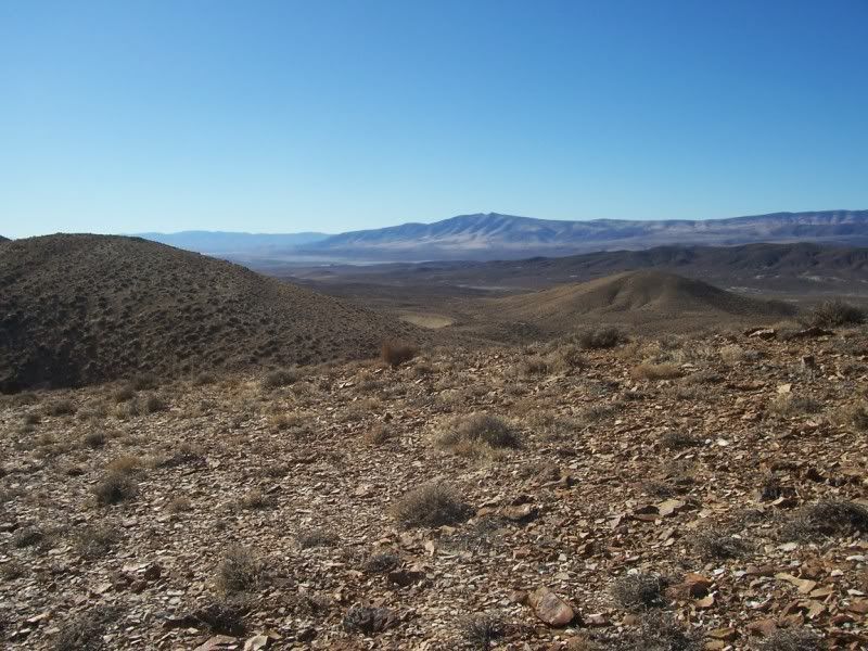
Another quarter mile and the trail forks; to the north it descends a long sandy wash and to the south it ascends another steep loose surface heading towards the peak. This climb is loose enough that the traction control starts to do its thing so I lock up the center differential. After another half mile the trail reaches the crest of a spur jutting to the north-west of the peak at a bit above 5000 feet. It’s a great view from here. To the west and about 18 miles away are the tops of Juniper Peak and Two Tips. To the south-west are the Fernley Sink and the town of Fernley at about 24 miles. About ¾ of a mile to the south-south-east is the top of Desert Peak.
The trail steeply drops and ends about 1000 feet beyond the viewpoint. There is a narrow ravine running up towards the peak. The ravine drops down a narrow canyon in the other direction and there is a hint of a trail steeply climbing towards another viewpoint bluff.
First I hike down the ravine for about 200 feet to see if it is passable. It looks like it will be fun. There are several dry waterfalls and narrow places, but the Disco should be able to handle them. Since there is no trail marked on the map for the ravine, I decide that I’ll look for its outlet from the bottom later on.
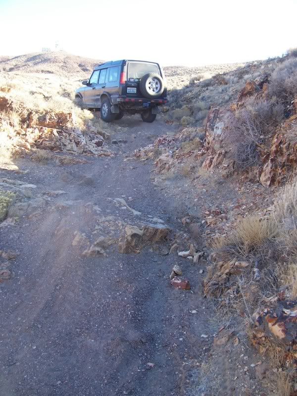
Next, I get back into the truck and start driving up the ravine towards the peak. There are some motorcycle and quad tracks so maybe it actually goes somewhere. The trail progressively gets steeper, narrower and rockier. After about 600 yards I come to a dead end, as least as far as a truck is concerned. The ravine climbs a couple of steep 8 to 10 foot high dry falls and then squeezes between a couple of rock pillars about three feet apart. There aren’t even any motorcycle tracks here. To the right of the ravine some two-wheeler tracks continue up the top of a moraine. Again a truck won’t work here.
I turn around and head back down to the trail end and then turn and climb up to the other viewpoint. From here I can see where the ravine below me opens onto the flats below me and about two miles to the north-west. I back-track the mile and a half to the junction; where the marked trail descends the sandy wash to the north.
This wash is full of moguls too; obviously also part of the motorcycle racing circuit. It’s a slow drive down to the broad sandy flats where the ground is dotted with prospects. There is a large diatomite mine tailing pile across the north-west side of the flat.
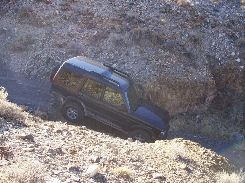
Eventually I come to a fork where another trail heads back towards the peak in the direction of the canyon that I reconnoitered on foot from the top. For a mile or so the trail climbs up a sandy wash headed towards the rockier part of the mountain. Once I reach the rocky canyon the gps confirms that I’m at the bottom of that ravine I explored up top.
Driving up the ravine is a blast! I get a chance to climb several rocky dry falls and squeeze through some narrow gaps. It’s a pity that I’m only able to take photographs of the easier ones. Next time I’m this way with a group, I’ll get some “action shots”. As it turns out the very last two rock climbs are the toughest requiring not only the CDL and the 4ETC but even a bit of momentum and wheel spin. At the top, I take a brief break, turn around and head back down. Believe it or not, a couple of spots were even tougher going down. I can’t wait to get Ben and Brendan up here.
After I get back to the flat; I head south looking for a way out towards the Brady Hot Springs geothermal field. There are no trails marked on the map here, but in reality there are several choices going in the general direction that I am going. Twice I take trails that dead end in washes that become box canyons and I have to figure out how to turn around in deep sand.
Eventually I wind up on a real trail and pretty soon it is even on the map! By 4:00 in the afternoon I can see Eagle Rock and some of the geothermal wells ahead. This has been a really fun day and I’m looking forward to bringing the guys back here. This has been the sixth single vehicle trek in a row now. I’m sure looking forward to some company!
Total mileage from Fernley returning to Fernley is about 70 miles. Of that, 30 miles is off-road and takes about five hours.

Searching for the Desert Queen Mines
It’s a beautiful day and a good excuse to get out and play. All of the packing, hauling, loading and unloading, super-cleaning the Rocklin house has worn me out. Playtime!
Today we’ll be exploring in the north end of the Hot Springs Mountains. I’ve taken you there before to Cinnabar Hill, the Fallon-Eagle Mines and the Desert Queen Mines. This time though, I intend to find a lot more shafts and adits that are supposed to be on the other side of the hill from the mines at the foot of the hills at the White Plains.
I leave the house and drive on pavement on US50 Alt to downtown Fernley and then east on I-80 to Bradys Hot Springs for a total of 25 miles. From now on it will be dirt all the way back to the house via the mountain range.
I head north-east for about four miles and then south-east. I try a few side trails that go towards the interior of the range. One is marked on the map and three are not. All eventually peter out and I have to return to the main trail. One of them, in fact, ends so abruptly at a cliff that I have to back down a steep incline. I hate doing that!
Eventually I enter the valley that flows for about five miles from Desert Peak towards White Plains in a northerly direction. I’ll be exploring the west side of Cinnabar Hill and the un-named hills that contain the Fallon-Eagle and Desert Queen Mines.
Near the strange little butte with all of the caves there are about a dozen short trails to explore. I think that the caves in the butte are probably archaeological sites although I have not found any references to that.
Pretty soon I turn east onto a long trail that according to the maps goes all the way to the pass between Desert Peak and Green Hill. Just a few hundred yards up this trail and I find an un-mapped trail that appears to head towards where I believe the Desert Queen Mine main workings are. For about a half mile the trail climbs to a saddle. From the top of the saddle I can see my destination.
The trail on the other side of the saddle is a mess. There are several old mine roads in various conditions. These trails go from bad to terrible to just ending at washed out ravines. For the next two hours I explore every passable trail that I can navigate. The whole time I have the CDL locked and still the traction control is doing its thing.
According to the map there should be a 4wd trail down a canyon on the south side that will take me back out to White Plains. I find it but its not something I want to try today alone. I’ll come back with partners at a later day. It looks like it should be fun though.
From the mines I retrace my route back to the Cinnabar Hill Canyon and then drive the pole line road back to Fernley. The run today has been 66 miles of which 41 were off-road.
- - - - - - - - - -
Land Rover Trek 132 – Scouting Desert Peak – Friday November 14 2008
- Or looking for a way to the top from the Desert Queen Mines –
Since the truck is still packed up from Wednesdays trek looking for the Desert Queen, I figure I’ll just hop in and go back to investigate the rest of that trail from the mines that runs up a wash for three or four miles towards Desert Peak. There really aren’t any roads shown on the topos that actually get there, but as there is a microwave tower and a radar reflector on top of the peak there must be a way up.
Anyway, I toss in some sandwiches, coffee and water and head out. The first part of the trek is the same as trek 131 as far as the Desert Queen except for the fact that I don’t explore any side trails on the way. 27 miles from Fernley, I pass the mines and start up the wash. The map shows a 4wd trail that stays pretty much in the bottom of the wash for the next couple of miles.
There are some off-road racing motorcycle clubs that frequent this area. Therefore, the wash is full of moguls. Generally when following dry washes in the boonies they are fairly smooth except for keeping an eye out for big rocks. When bikes race in them it’s a totally different matter. This wash is a mess!
Just before reaching a saddle the trail crosses an old lava flow and stays pretty rocky from there on. A quarter mile beyond the saddle I encounter a steep climb in loose gravel and sand. The Disco handles it pretty easily, though I may have to give Bens Montero a tug whenever he follows me this way.
Another quarter mile and the trail forks; to the north it descends a long sandy wash and to the south it ascends another steep loose surface heading towards the peak. This climb is loose enough that the traction control starts to do its thing so I lock up the center differential. After another half mile the trail reaches the crest of a spur jutting to the north-west of the peak at a bit above 5000 feet. It’s a great view from here. To the west and about 18 miles away are the tops of Juniper Peak and Two Tips. To the south-west are the Fernley Sink and the town of Fernley at about 24 miles. About ¾ of a mile to the south-south-east is the top of Desert Peak.
The trail steeply drops and ends about 1000 feet beyond the viewpoint. There is a narrow ravine running up towards the peak. The ravine drops down a narrow canyon in the other direction and there is a hint of a trail steeply climbing towards another viewpoint bluff.
First I hike down the ravine for about 200 feet to see if it is passable. It looks like it will be fun. There are several dry waterfalls and narrow places, but the Disco should be able to handle them. Since there is no trail marked on the map for the ravine, I decide that I’ll look for its outlet from the bottom later on.
Next, I get back into the truck and start driving up the ravine towards the peak. There are some motorcycle and quad tracks so maybe it actually goes somewhere. The trail progressively gets steeper, narrower and rockier. After about 600 yards I come to a dead end, as least as far as a truck is concerned. The ravine climbs a couple of steep 8 to 10 foot high dry falls and then squeezes between a couple of rock pillars about three feet apart. There aren’t even any motorcycle tracks here. To the right of the ravine some two-wheeler tracks continue up the top of a moraine. Again a truck won’t work here.
I turn around and head back down to the trail end and then turn and climb up to the other viewpoint. From here I can see where the ravine below me opens onto the flats below me and about two miles to the north-west. I back-track the mile and a half to the junction; where the marked trail descends the sandy wash to the north.
This wash is full of moguls too; obviously also part of the motorcycle racing circuit. It’s a slow drive down to the broad sandy flats where the ground is dotted with prospects. There is a large diatomite mine tailing pile across the north-west side of the flat.
Eventually I come to a fork where another trail heads back towards the peak in the direction of the canyon that I reconnoitered on foot from the top. For a mile or so the trail climbs up a sandy wash headed towards the rockier part of the mountain. Once I reach the rocky canyon the gps confirms that I’m at the bottom of that ravine I explored up top.
Driving up the ravine is a blast! I get a chance to climb several rocky dry falls and squeeze through some narrow gaps. It’s a pity that I’m only able to take photographs of the easier ones. Next time I’m this way with a group, I’ll get some “action shots”. As it turns out the very last two rock climbs are the toughest requiring not only the CDL and the 4ETC but even a bit of momentum and wheel spin. At the top, I take a brief break, turn around and head back down. Believe it or not, a couple of spots were even tougher going down. I can’t wait to get Ben and Brendan up here.
After I get back to the flat; I head south looking for a way out towards the Brady Hot Springs geothermal field. There are no trails marked on the map here, but in reality there are several choices going in the general direction that I am going. Twice I take trails that dead end in washes that become box canyons and I have to figure out how to turn around in deep sand.
Eventually I wind up on a real trail and pretty soon it is even on the map! By 4:00 in the afternoon I can see Eagle Rock and some of the geothermal wells ahead. This has been a really fun day and I’m looking forward to bringing the guys back here. This has been the sixth single vehicle trek in a row now. I’m sure looking forward to some company!
Total mileage from Fernley returning to Fernley is about 70 miles. Of that, 30 miles is off-road and takes about five hours.