SGTTOM
New Explorer
Hello,
My name is Tom and I wanted to share some pictures and experiences from my trip this last weekend to Anza Borrego. I am new to the community and this is my first vehicle based journey into the back country. I'll start by saying thank you to this forum and website. As I was planning my trip I received so much information from users on this forum, on everything from gear to routes. All of it was extremely useful and reliable, and I plan on using this resource to help plan my next adventure. I credit this forum with making my trip fun, successful, and safe.
I took lots of pictures and unfortunately I didn't charge my camera (mote for next trip), so most of these pictures were taken through my iPhone. This doesn't help the fact that I am a poor photographer, so bear with me.
I had already been planning on doing a trip for some time with my original goal being the Bradshaw trail (also in So-Cal). After seeing forecasted temps reaching well over a hundred for that weekend my wife and I had decided to head to the mountains instead. Again after much flip-flopping we finally the day before decided for destination would be Anza Borrego State Park. The allure and mystery of this very beautiful desert park was just too great to turn down, and we knew this could be our last chance until next year to visit it. We had been there before, but only to one area and knew there was much to explore. I did some research on the internet (mostly asking around on this forum) and picked out some possible areas to check out. I printed out some materials and a map and packed the truck for the adventure to come.
Day 1-
Not having any solid plans we decided to enter the park through Hwy S22 and head in to the town of Borrego Springs, which is an unincorporated community of San Diego County, and is surrounded entirely by Anza Borrego State Park. The drive from the Salton Sea to Borrego Springs starts off as a not so scenic drive, but that quickly changes as you pass through Ocotillo Wells OHV recreation area. As you drive toward town you enter the park through the Ocotillo Bad Lands, a unique and mesmerizing canyon system with hundreds of washes and muti-colored mineral deposits striping the landscape. The highway takes you on top of these canyons and as we drove we could look down and see the occasional jeep way down below exploring the maze of sand and narrow slots.
Once we got to Borrego Springs we stopped by the Park Headquarters Visitor Center in order to gain some better materials and knowledge. Here I acquired a through guide book and detailed map which proved to be a priceless asset on our journey just hours later.
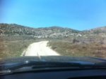
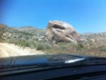
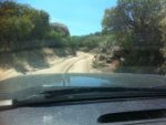
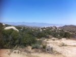
We then took off continuing up Hwy S22 and climbed up into the higher elevations of the North Western portion of the park, the terrain changing from desert flora and cacti to yuccas, manzzinitas, and oaks. It wasn't long before we reached our first dirt road. Tires on dirt and aired down we excitedly started our adventure on Old Culp Valley Road. This road was hard packed and very easy to navigate in my full-size Silverado. There were some loose rocks here and there and I could see the road becoming muddy in the rain, but in the condition it was in that day four wheel drive wasn't required until later. Old Culp Valley Road was a relaxing drive that offered to great vistas where on a clear day you can see all the way down to the Salton Sea. On this road we took a side road up to a place called The Slab where we stopped for a picnic in a beautiful spot where the landscape was dotted with massive boulder out crops.
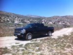
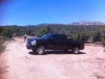
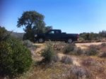
After lunch we made our way down to Jasper Trail, which is classified as a jeep trail. The trail seemed to be holding as a beautiful easy drive so we decided to keep following it down in to a canyon where we would link up with another dirt road. Well, the easy didn't last long as we made a somewhat steep assent and came round a corner to what seemed like a narrow road with a dirt and rock wall on one side and a steep drop on the other. In a jeep this may not seem so narrow but in my full-size truck I felt my heart begin to beat as I asked my wife to poke her head out the window to make sure we weren't going to drive off the mountain. We successfully rounded this hairy corner to a steep bumpy decent, which we navigated through without any problem. Once we made it to the bottom we took a breather and decided no more jeep trails unless it is a wash. We continued down Jasper Trail and encountered some more rocky but not too crazy of areas, but tons of bushes which reached out to crissen my truck a trail truck (lots of scratches). After about half-an hour we finally reached the dirt road that would put us back out on Hwy S22. All of this drive was beautiful and fun, even with the hairy parts. This trail would be much more enjoyable with a more nimble vehicle. My truck made it but as a new driver it made me nervous, if you want to take your full-size on Jasper Trail are prepared for bush wackin, and narrow roads. I would not take a truck with a widened wheel base on this trail. I must say that it was a confidence booster and made me feel that was driving a solid rig. It is definitely a jeep trail!
After we followed the dirt road (which actually connects Hwy S22 and Hwy 78) we arrived back to the pavement on Hwy S22.
 (Ingnore the thumbnails I couldn't get them to go away, all pics are down below now. Thanks)
My name is Tom and I wanted to share some pictures and experiences from my trip this last weekend to Anza Borrego. I am new to the community and this is my first vehicle based journey into the back country. I'll start by saying thank you to this forum and website. As I was planning my trip I received so much information from users on this forum, on everything from gear to routes. All of it was extremely useful and reliable, and I plan on using this resource to help plan my next adventure. I credit this forum with making my trip fun, successful, and safe.
I took lots of pictures and unfortunately I didn't charge my camera (mote for next trip), so most of these pictures were taken through my iPhone. This doesn't help the fact that I am a poor photographer, so bear with me.
I had already been planning on doing a trip for some time with my original goal being the Bradshaw trail (also in So-Cal). After seeing forecasted temps reaching well over a hundred for that weekend my wife and I had decided to head to the mountains instead. Again after much flip-flopping we finally the day before decided for destination would be Anza Borrego State Park. The allure and mystery of this very beautiful desert park was just too great to turn down, and we knew this could be our last chance until next year to visit it. We had been there before, but only to one area and knew there was much to explore. I did some research on the internet (mostly asking around on this forum) and picked out some possible areas to check out. I printed out some materials and a map and packed the truck for the adventure to come.
Day 1-
Not having any solid plans we decided to enter the park through Hwy S22 and head in to the town of Borrego Springs, which is an unincorporated community of San Diego County, and is surrounded entirely by Anza Borrego State Park. The drive from the Salton Sea to Borrego Springs starts off as a not so scenic drive, but that quickly changes as you pass through Ocotillo Wells OHV recreation area. As you drive toward town you enter the park through the Ocotillo Bad Lands, a unique and mesmerizing canyon system with hundreds of washes and muti-colored mineral deposits striping the landscape. The highway takes you on top of these canyons and as we drove we could look down and see the occasional jeep way down below exploring the maze of sand and narrow slots.
Once we got to Borrego Springs we stopped by the Park Headquarters Visitor Center in order to gain some better materials and knowledge. Here I acquired a through guide book and detailed map which proved to be a priceless asset on our journey just hours later.
We then took off continuing up Hwy S22 and climbed up into the higher elevations of the North Western portion of the park, the terrain changing from desert flora and cacti to yuccas, manzzinitas, and oaks. It wasn't long before we reached our first dirt road. Tires on dirt and aired down we excitedly started our adventure on Old Culp Valley Road. This road was hard packed and very easy to navigate in my full-size Silverado. There were some loose rocks here and there and I could see the road becoming muddy in the rain, but in the condition it was in that day four wheel drive wasn't required until later. Old Culp Valley Road was a relaxing drive that offered to great vistas where on a clear day you can see all the way down to the Salton Sea. On this road we took a side road up to a place called The Slab where we stopped for a picnic in a beautiful spot where the landscape was dotted with massive boulder out crops.
After lunch we made our way down to Jasper Trail, which is classified as a jeep trail. The trail seemed to be holding as a beautiful easy drive so we decided to keep following it down in to a canyon where we would link up with another dirt road. Well, the easy didn't last long as we made a somewhat steep assent and came round a corner to what seemed like a narrow road with a dirt and rock wall on one side and a steep drop on the other. In a jeep this may not seem so narrow but in my full-size truck I felt my heart begin to beat as I asked my wife to poke her head out the window to make sure we weren't going to drive off the mountain. We successfully rounded this hairy corner to a steep bumpy decent, which we navigated through without any problem. Once we made it to the bottom we took a breather and decided no more jeep trails unless it is a wash. We continued down Jasper Trail and encountered some more rocky but not too crazy of areas, but tons of bushes which reached out to crissen my truck a trail truck (lots of scratches). After about half-an hour we finally reached the dirt road that would put us back out on Hwy S22. All of this drive was beautiful and fun, even with the hairy parts. This trail would be much more enjoyable with a more nimble vehicle. My truck made it but as a new driver it made me nervous, if you want to take your full-size on Jasper Trail are prepared for bush wackin, and narrow roads. I would not take a truck with a widened wheel base on this trail. I must say that it was a confidence booster and made me feel that was driving a solid rig. It is definitely a jeep trail!
After we followed the dirt road (which actually connects Hwy S22 and Hwy 78) we arrived back to the pavement on Hwy S22.
(Ingnore the thumbnails I couldn't get them to go away, all pics are down below now. Thanks)Attachments
Last edited:


