You are using an out of date browser. It may not display this or other websites correctly.
You should upgrade or use an alternative browser.
You should upgrade or use an alternative browser.
GPS purchase - offer your guidance
- Thread starter Desertdude
- Start date
Ursidae69
Expedition Leader
Ursidae69 said:I just bought the Magellan Explorist 600. Once I get it and test it out, I'll let you know what I think.
Chuck...
Thought I'd post a little follow up on the Magellen I have been using.
Here is some background info on the unit.
It retails for > 450, but I found one for about 350 online. The main reasons that I got this unit are the small size, bright color screen, less than 6 ounces, internal SD memory cards, rechargeable lithium ion battery, 14 parallel channels supported by WAAS and EGNOS, and the electronic 3-axis compass.
Using it for days on end never turning it off, it has not once frozen up or stopped working. It is easy to save routes, tracks, and waypoints. You can also save text with each waypoint similar to metadata in a GIS (Like the species of critter I'm collecting the waypoint for).
Problems I don't like are: the mapSend software isn't that great, it's difficult to transfer files to and from the unit, the street to street navigation is not that great, and the track log or "cookie crumbles" are not customizable, as far as I can tell anyway.
On a scale of 1-5, for me and my needs, I give it a 4. For others here that have posted in this thread and what your needs are, this unit might be a 3 or 3.5.
My view on GPS units is greatly swayed for how I use it. This may be long and bit thrown together (disjointed).
I need something that has a good antenna, simple, weather proof, run on alkaline batteries, b/w screen, WAAS (for when those stations come online in the continental interior), at least 500 waypoint memory and last price.
For hand held GPS, I prefer the quadrapole antenna vs. the patch. Over the years I have found that they give a bit better performance, especially with issues seeing the sat. constellation (canyons, trees, etc). For general use it is less of an issue.
I like alkaline batteries because you can pick them up anywhere. In cold conditions you can keep a set in your pocket as well. When I am working, I transfer batteries out of the unit once it reaches ~50%. Power in the unit does effect performance. I then use those batteries for flashlights, iPod, etc.
I prefer b/w screens. They use less power and are easier to see in direct sunlight.
I like a portable handheld for collecting data in the field. I don't need a big screen or loaded maps for navigation in the field as I always have a paper map for that that.
For in the vehicle navigation I use a laptop. The screen size on the handhelds are just too small to navigate, especially as the driver (I don't do this in traffic). I use an old Mac G3 Powerbook "bronze" laptop. I am not happy with this set up as the laptop takes up too much room if there is a passenger. I am looking into getting a ~7" touch screen LCD monitor (like the Lilliput). They range in price from $150-$250. I can then operate the laptop mounted under the DS seat (maybe) in clamshell mode with an integrated trackball&keyboard. If I were getting a dedicated computer for the car, I would make sure I was WiFi and bluetooth enabled in order to give greater mounting options.
Those are some of my thoughts on this topic. I have thought alot about this and been researching it though my presentation is a bit goofy.
Ross
RAM5500 CAMPERTHING
OG Portal Member #183
expeditionswest said:If I was buying a new model, it would be the Garmin 276c
http://www.thegpsstore.com/Detail-Garmin-GPSMAP-276C-standard-package.asp
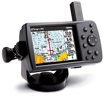
I do know that Chris and Uwe have had good luck with their Magellans too.
My Garmin Vista has been a great unit, but too small for vehicle use.
I know i am a little late here, but i will chime in anyway!
Thats the unit i got and i LOVE it!
It can be used for turn by turn voice directions, or simply shut that feature off and use it offroad.
Dont have a single complaint about this unit, other then the awkward size which makes it kind of hard to install in my FZJ
I highly recommend this!
Unit costs around $550 then the street kit $200 then the sunction mount $50 then the Baja maps $100 and it is STILL very much worth the $
The more i use it, the more i like it!
I looked at the 376C with the weather and such, but decided it wasnt for me. Very happy with my decision!
Only thing that i cant figure out that is driving me nuts is the automatic zooming out feature! I like to use it @ the 300ft scale and it has a habit of zooming out to like 1.2mile or something each time a prompt comes up! Kind of annoying! Anyone know a cure?
My .02
Here is a pic of the unit using the RAM suction mount (which vibrates a little too much for my liking):

And here is a pic of my hard mount using an external antenna (this actual pic was for fitment only and still shows the old antenna! This mounting setup is not as easy to see, but no vibration and its out of the way of everything):

Last edited:
RAM5500 CAMPERTHING
OG Portal Member #183
UncleChris said:I have one with the Garmin Topo maps on it and another with the Garmin Street maps on it. That way you can switch to the topos once you hit the trail.
If you have both the Street and the Topos maps loaded on one card you EASILY can switch between them in the unit itself.
In The Navigation Screen
-Choose Map Information
-Highlight and use the check boxes to Check and Uncheck what you want and dont want to see.
That way you can do it all on one card! I use this going between the maps for the US and Mexico, if i dont unselect the US maps when i am in Mexico, things get kinda funky!
I got everything loaded on my 256mb card and just switch it in the unit. Pretty cool!
RAM5500 CAMPERTHING
OG Portal Member #183
Desertdude said:I am concerned with disconnecting the power/speaker cable fromn the unit time after time - I think that could create issuse down the line.
The speaker in the power cable drove me nuts! I bought a $12 power cable from GPScity without the speaker and it works awesome!
gjackson
FRGS
I use and love the older GPSMap 176, which has the same appearence, but a B&W screen and no USB hook-up. Have found it very easy to read while driving. Here's an old pic:

As a note, the Garmin mount base you see in the picture lasted about 2000km in the Sahara before breaking. The nut you can see welded to the plate just to the right of the GPS was my backup mount and has worked flawlessly since the other one broke. I have also mounted an external antenna since I got back. The data and power cables are both wired into the truck, with the data cable going to the laptop stand for more advanced navigation.
The one complaint I have is that the unit has no memory as it comes. In order to load maps into it you need to buy a memory stick. Not a big deal, but a bit of a pain.
I like your low down mount. Keeps the GPS pretty well hidden.
cheers
Desertdude
Expedition Leader
The speaker in the power cable drove me nuts! I bought a $12 power cable from GPScity without the speaker and it works awesome!
I am addicted to the turn by turn directions in the city

Through a stroke of luck I aquired the Baja Topos you spoke about on mud - I will load these as well as the other maps I have previously loaded in.
Hey desertdude,
I wanted to update you on the new version of MacGPS Pro. It is a vast improvement over previous versions. I just got an update that allows for the stitching of maps. I don't know how well this works yet, but that would fix my last complaint w/ the software.
The new GUI interface will work really well with a touch screen. I just need to pony up the cash for one.
The new 'auto map open' fxn works great and simplifies things. It is great software for the price. I now just need to get ahold of a good Mac street atlas software. The only time I think this will be most useful for me in Utah as I have been joking with friends about developing a GIS database of all the state liquor stores w/ locations and times of operation.
***EDIT*** The auto stitch seals the deal on this for me, it works very well. I will not go with OZI explorer in the short term.
Ross
Last edited:
Desertdude
Expedition Leader
Thanks Ross and Graham - Just ordered it along with a few maps - It says it works with the USB and 276c - I look forward to messing around with this and learning more about the technology. :luxhello:
Desertdude
Expedition Leader
GIS database of all the state liquor stores w/ locations and times of operation.
This could be quite useful :chowtime:
RAM5500 CAMPERTHING
OG Portal Member #183
Desertdude said:I am addicted to the turn by turn directions in the city
Through a stroke of luck I aquired the Baja Topos you spoke about on mud - I will load these as well as the other maps I have previously loaded in.
Which ones? There are a few different versions?
Let me know if ya got any questions on them!
Desertdude
Expedition Leader
Thanks Kevin - they are being mailed to me from AZ - should have those next week.
Thanks to Ursidae69 Navigation Winner, 2005 Expedition Trophy for the donation :sunny:
Thanks to Ursidae69 Navigation Winner, 2005 Expedition Trophy for the donation :sunny:
xcmountain80
Expedition Leader
expeditionswest said:If I was buying a new model, it would be the Garmin 276c
http://www.thegpsstore.com/Detail-Garmin-GPSMAP-276C-standard-package.asp
I do know that Chris and Uwe have had good luck with their Magellans too.
My Garmin Vista has been a great unit, but too small for vehicle use.
How about the Garmin 376c so that no matter where you are you can be subscribed to the xm sattelite imagery right on your GPS. Seeing as how Money is no object the unit runs $999 and the Starup for xm Weather service is $200 and $100 per month. But I think this would be the cats ass in terms of Navigation.
Aaron