Impression of PDA based GPS system?

Ryanmb21

Expedition Leader
I found a very interesting thread on another board:

http://www.ultimateyota.com/index.php?option=com_smf&Itemid=26&topic=914.0

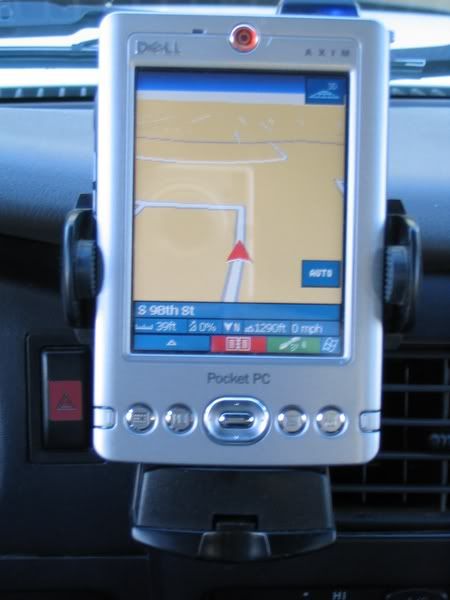
In it, a PDA based GPS setup is discussed. It seems as this is a VERY good option, it is updateable, you can use wifi internet, the screens are bigger than average, can be updated for your choice of on-road and off-road software and the cost seems very reasonable. There is no "out of the box" solution as you have to buy the PDA, the gps receiver and the software...

So it begs the question: what do you guys think? Is it too much trouble?

Thanks
 

Dave

Explorer
I use an old HP iPaq 3835 with a Navtech GPS Sleeve. One downside of my setup is the battery is zapped, so I use it just in the truck. Even if the battery was better, it's not really rugged enough for hiking or canoing. Too bulky for that too.

For software, I use Mapopolis. Mapopolis used the Navteq data and I was really happy with that software. Apparently they sold their code to a larger company (yet to be named) and are no longer selling to the public. I wish I could recommend it, but since it's not available it's pointless too.

I've also used National Geographic topo maps on it, but those are around $100 per state, so I never bought more then my home state.

I like my setup for all the reasons you listed: large screen, touch screen, options for software, etc. Rerouting and searching for an address on mine is a little slow, but I've always assumed it's because my PDA is really old.

For me, the PDA based system works great for traveling. I've been really surprised at just how many back roads and "trails" are part of the Navteq data. Most logging roads, forest roads, county roads, etc. are available on the maps I have. Honestly, I think software is the most important part of PDA based systems. If the software stinks, it doesn't matter how fancy the hardware is. One feature I would LOVE to have with my software is the ability to add POI's or routes on the laptop and then upload them to the PDA.

You can buy packages that come with all the hardware and your choice of software.

So anyway, for me it works great. I do have a handheld for hiking and canoeing, but I barely use it.
 

1leglance

2007 Expedition Trophy Champion, Overland Certifie
I have used a palm pda and now windows mobile pda gps system for years with great success.
My current setup is a treo 700wx with a globasat bluetooth gps that has a removable battery that last 15hrs. I like that I can travel with it, hike with it, drive with it and let the kids play with it :)
On road I use Iguidance now and TomTom in the past...
Off road I have tried a number of things but am currently using beeline gps and will soon test oziexplorer CE.
There are many solutions with maps but I haven't tried those.
enjoy
1leglance
 

Jeeptrekker

New member
I just joined this forum and I guess I will jump in here.

I use an IPAQ 4155 with Memorymap Navigator software. A Royaltek BlueGPS sends the gps data (over bluetooth) to the Ipaq. I load USGS quads onto the SD card for the area I will be traveling in and off I go. This setup gives me the functionality that you would get from a Garmin but with more map detail and a bigger screen. You have to go through a litte routine to fire the system up (turn off other programs currently running on the IPAQ, get the IPAQ to find the GPS bluetooth signal then turn on the mapping software) but after that it works great. I would still like a bigger screen, somewhere 1/2 way between the IPAQ size and Laptop size, but I haven't found one yet. (I have to admit I haven't looked too hard lately)

Richard
 

flyingwil

Supporting Sponsor - Sierra Expeditions
I used to use a Dell Axim X30H PDA, and a Bluetooth GPS. I modified a glass powered PDA mount and mounted to where the air bag selector witch would be in a mini or a xtra cab. This unit caught on fire, and I am looking to replace it with a carpc.
IMG_0555.jpg


IMG_0551.jpg


The above photo is my PDA running OnCourse Navigator, which will automatically direct you to your destination along with voice prompts.

The Rikaline GPS is tweeked for accuracy while flying... (I use Pocket FMS) and from the trial and error I learned has to be retweeked during ground usage, with OutDoor Navigator.

With the PDA I was able to use Bluetooth to access the Internet and surf the web and download Topo's.

Overall once you get one and start playing with it, you will want to go to a dedicated computer to get even more functionality out of it. I would not recommend it for geocaching, or outdoor use due to the battery life.
 

Forum statistics

Threads
186,384
Messages
2,885,286
Members
226,303
Latest member
guapstyle
Top