In search of the ancient ones

WU7X

Snow on the Roof
I heard a very interesting comment while attending the Overland Expo this year; "An overland adventure doesn't begin when you take a trip. It begins when the trip takes you". I left Mormon Lake Sunday afternoon and made my way to a cheap hotel near the University district in Flagstaff. I was more than comfortable sleeping in my rooftop tent, but after seven days of sun and dust I was ready for a long shower and a quiet night's sleep away from the crowds. After playing the tourist Monday morning, drinking a well made Starbucks coffee and picking up Dan Brown's latest book at the local Barnes & Noble, I drove out to Flagstaff International and picked up my hiking buddy Kent. And that was when the adventure truly began.

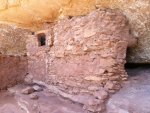
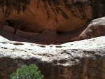
We had been planning this trip for several months. The previous October had found us hiking for four days through the Grand Canyon. On our way home to Spokane, we made a detour to Comb Ridge for a quick day's hike. We had heard that there were Anasazi ruins all along Comb Ridge. Why not try to find one or two? Well, we really didn't discover ruins, but we did find this:

IMG_1425.jpg

This image of a crane had a fateful power over the both of us. Suddenly, we were like a couple of kids in a candy shop; we wanted more. But the time had come for us to head back to Spokane. As we made our way back to the 4Runner we began to plan our return trip.

Overland Expo was coming up the following May, 2013. Kent had no desire to watch me drool over the dualsport bikes and assorted overland gear. So we agreed that he would fly down and meet me the day after Expo closed its doors for the year. After picking him up at the airport we were off.

The trip to Cedar Mesa in southern Utah took us past all kinds of incredible semi-destinations. First there was Wupatki National Park and its well preserved Anasazi ruins. Just what we needed to further wet our appetites.

IMG_1281.jpg

Then Monument Valley.

IMG_1502.jpg

And then Valley of the Gods.

IMG_1451.jpg

Finally, you get to drive up Moki Dugway to reach Grand Gulch and Cedar Mesa.

IMG_2050.jpg

We decided to go straight to the BLM ranger station and pick up a one week permit. It is a lot quicker, and cheaper, than paying for the individual permits at each of the trailheads we planned on camping at. The BLM personnel were a cheerful group who gave us support and advice on our adventure. With permit in hand, we drove off.
 

WU7X

Snow on the Roof
Before I continue this story I would be remiss if I didn't let you in on a great camping spot just north of Mexican Hat. Goosenecks State Park is a bit primitive for some. It has a single pit toilet, but no water or other amendities. But the view makes up for all of that! If you ever want to get a good visual of the geologic term meandering stream you have to stop at Goosenecks. I spent one night there on the way to OX. And Kent and I spent our first night out of Flagstaff there before driving up Moki Dugway. A single iPhone picture taken in the early morning just doesn't do justice to this spot.

IMG_2004.jpg

Back to the story. After leaving the ranger station, Kent and I drove down to McCloyd (sp?)Gulch. Our first destination of this adventure was Moon House. These ruins are pretty well known and visited. However, the rangers had told us that most visitors just hike over to Moon House, take a few pictures and explore a bit, then leave. The trick to to also explore further up and down the gulch for more treasures. So that is what we did.

IMG_2069.jpg

To the left of, and a good hike away from, the primary cluster of Anasazi buildings at Moon House we found several ruins that were in really poor condition. But they did include the only "T" shaped door I found in the area.

Moon House and its associated buildings are simply marvelous. The interior of one of the rooms has a white band a foot or so wide painted horizontally along the interior walls. There are symbols of several phases of the moon marked in this paint. The artist had dipped his thumb into the paint pot and left a series of white dots above the white band. I'd like to go back and see if there are 28 per wall. Sort of a lunar calendar effect so to speak.

IMG_2102.jpgIMG_2111.jpg

We then walked past Moon House and continued to the east. We found three more rooms, these even more impressive in their masonry. I had never read anything about this in my research, but we also found several subrounded rock bordered beds lying up against the red mudstone natural rock walls overlying the white sandstone ledge that these structures are built on. They were filled with what I conjure to be soil and were used as garden plots on the ledge itself. Water permeating out of the soft mudstone would be caught in the rock lined bed. I'd like an expert to tell me if my guess is correct or not.

IMG_2128.jpgIMG_2143.jpg

Moon House is pretty easy to get to, if you're used to heights and some rock scrambling. Rock cairns lead the way in and out. The road to the trailhead would be a real bear in the rainy season. Even the smallest shower will turn parts of the road into a quagmire. Other parts of the road traverse slickrock hummocks and ledges. I put my 4Runner into 4H once, just to show Kent how it was done, and into 4L 2nd gear at one point to crawl over a couple small ledges. Nothing dramatic; just took our time in and out.

You cannot camp at the trailhead for Moon House. However, there is this perfect site several miles away on state land. It is just off the access road and lies between the road and the rim of the canyon. Camping there and watching the sunset and rise was glorious.

IMG_2150.jpgIMG_2153.jpg
 
Last edited:

WU7X

Snow on the Roof
I'd love to put up a video of the campsite where we ended up after visiting Moon House. Unfortunately, I don't know how. I'd also like to put up some video of our attempt to reach the Citadel. Oh, well....let's see if this will work.

https://www.facebook.com/video/video.php?v=10201155129709378&notif_t=video_processed


The next morning, after a huge meal of ham & eggs, et al, we broke camp. This day's target would be the Citadel. It is a very hard to reach this Anasazi ruin perched at the terminus of a spindly peninsula and invisible until one actually gets out to it. The BLM really doesn't like people to try getting out to it, probably for safety reasons. Once at the trailhead the hike in is somewhat long but pretty easy. The hard stuff doesn't occur until you are practically there. The sedimentary rocks here are composed of sandstones, some limestone, and shales/mudstones from what I observed. There are alternating beds of these rocks, all pretty much still in a semi-horizontal position. The shales and mudstones weather out much more rapidly than the other two types of rocks. This creates a series of ledges, one on top of another. Sometimes it is relatively easy to slip from one to the other. But often you can get ledged out pretty quickly. Well, we hiked in, found where the Citadel was located but couldn't find the way off our top ledge to a lower one which would afford us access to it. There are also a couple of graineries located at some distance to the west of the citadel, but they too are on that lower ledge. We finally found the way down, we think. Actually, there is a way down to the Citadel and a second way down to the graineries. We found them, but we didn't want to try them until we are absolutely certain we can get down and back. Being 60 and 65 years old has slowed us down a bit. And we have discovered recently that we aren't actually immortal anymore. But we're coming back, better prepared next time. I will say to anyone thinking about attempting this, stay to the right. If you've gone all the way to the end of the promotory overlooking the peninsula leading to the Citadel, you've gone a wee bit too far. After that, you're on your own. Sure wish I could get the video up. Kent has some additional pictures that I will be getting in a couple days. I'll edit this and put up something better then. This two shots are way up toward the head of the canyon. So they don't really give you an idea of it's depth near the Citadel. A rough guess would be that the canyon walls have to be around 600-800 feet deep there. You fall, you probably die.

IMG_2162.jpgIMG_2161.jpg

The Earth Goddess always seems to want a little blood sacrifice from me every time I go on an adventure. She got it from me at the Citadel. We had stopped for lunch and to gulp down a liter or two of water. We were squatting in the sand under several large slab rocks. Getting away from the sun and wind felt good. I really didn't notice anything happening until we got back to camp. It was then that I saw about a dozen little red pinhead sized spots on each of my lower legs. I don't know if they were sand fleas, gnats, no-see-ums, or what have you. But they had made a good meal out of me. To jump ahead a bit, the next day the spots were swelling up a bit and starting to itch. I knew better than to scratch, but they continues to get worse. A week later, when I was already back home, my wife finally collared me and took me to the doc-shop. I'm allergic to the little bastages it seems. I'm on a week's dose of Prednisone and cortizone. When we go back I'm going to be covered in DEET or some other scourge of all things invisible and hungry. And no, I'm not going to show you a picture of these fug-ugly legs. Kent, by the way, got bit a couple times, but the spots were gone by the time we got home. Life sometimes isn't fair. :sombrero:

I almost forgot something else. We stopped at another state park. It was not in one of the canyons. Instead the site was on a low hilltop overlooking the entire area. Totally enchanting. There were a series of ruins there, primarily of the bases of building, a tower, and the most beautiful kiva I have ever seen. I could give you exact locations for all these spots. But what fun would that be?

IMG_2165.jpgIMG_2169.jpg

After visiting there, we found another nice camp spot and settled in for the night.

IMG_2172.jpg
 
Last edited:

Kiwi-Yank

Adventurer
great pix ... thanx !!
don't you wish you were still relaxing in that chair and reading your book?
Hahahaha!

Kiwi-Yank
 

WU7X

Snow on the Roof
Every adventure provides us with a set of new possibilities offset by a similar set of compromises. This would be our last day on Cedar Mesa before having to head back to Spokane and our other lives. Should we use this last day as we did searching for the Citadel, or should we play it safe and follow our friendly BLM ranger's advice and go to a known site? We already knew we'd be coming back, and more than once if possible. So we decided to head up to South Mule Canyon and hike into view House on Fire. House on Fire is the first of a series of ruins perched on the west side of the canyon. It is named so because if you catch it when the sun is striking directly on it, it really does look like it is aflame. The canyon, once you actually get into it, is stunning. Its floor is covered with vegetation, and at this time of the year, the wild flowers were all ablaze. Besides the typical pinion/juniper trees of this ecosystem, there were also stands of Ponderosa pine and a few firs mixed in too. The valley floor had numerous standing pools of water. We also came across a huge plunge pool underneath a ledge of sandstone. It was very tempting to strip down and take a swim, as the afternoon sun was ferocious and the cooling thermals had temporarily stopped blowing.

IMG_2201.jpg

But, I'm getting ahead of myself again.

House on Fire was our first destination. Again, the work was pretty impressive. It always makes me wonder what will be left of our communities in another 800-1,200 years. Will they fare this well?

IMG_2181.jpgIMG_2182.jpg

IMG_2187.jpgIMG_2183.jpg

Guess we didn't catch the house on fire...too early in the day, and time was wasting. So off we trundled to locate the second site. These ruins really appeared to be of a lower quality of construction. Were they built at an earlier, less technical time? Or were they built later as the Anasazi civilization fell into decline? Who knows?

IMG_2192.jpgIMG_2196.jpg

It was only late morning, so we decided to hike on up the canyon. We were pretty sure that there would be more to see. Boy, were we right! The last ruins we found that day were stunning. They are located so high up the canyon wall, and were hidden so well by shade from the overlying ridge we nearly missed them.

IMG_2211.jpg

Here is a short video of this site. https://www.facebook.com/video/video.php?v=10201155188270842&notif_t=video_processed

If you look above Kent in the picture, directly below the massive manganese stained upper ledge, you can just barely make out the ruins in the shadows. We scrambled up the rampart of rock before them, only to be blocked once more by a massive ledge. This white sandstone ledge butts out above one's head a good 20-30 feet. The direct route was blocked. Searching to each side of the ledge on which this site is built also proved fruitless. So there we stood, 150 feet from our quarry and we couldn't do anything more than stare at it. And it is magnificent! Probably the best masonry we've seen so far. Kent said he would happily hire the masons to work on his home. I told him we could dig around a bit and see if we could locate them.

The attached thumbnail below shows a bit of a closeup of the site. You can see three buildings behind a sturdy wall. The wall has a doorway built in. What you can't see the the steepness of the ledge leading to the wall. Nor can you see the wooden staircase built behind the wall leading to those buildings. You also cannot view the entryway to at least one more building those three in view. Can you imagine a young woman, with baby on hip, moving up and down that ledge? How about an old man, or someone who is incapacitated? I can only imagine access via a ladder of some sort. We're going back there, and with a portable ladder of some sort.

This site also contains a lot of pottery shards, husks of very small maize, and jasper or flint chips mixed with the soils below that formidable ledge. This site is on public lands and is considered an antiquities site. So look, pick them and and enjoy them, then put them back down exactly how and where you found them. Let others who come later also have the joy of seeing them.
 

Attachments

  • IMG_2191.jpg
    IMG_2191.jpg
    565.8 KB · Views: 3
  • IMG_2217.jpg
    IMG_2217.jpg
    555.9 KB · Views: 6
Last edited:

mph

Expedition Leader
Glad you got to explore the Mesa...A great, unique place in Utah. Glad to hear you will be back...I have probably spent 50 days on the Mesa and always find some neat new place to explore, camp, or hike...

Until next time! Thanks for the writeup and pics!
 

WU7X

Snow on the Roof
After hiking back out to the rig, we drove to Moab and spent the night at a nice BLM campground just north of town. Really upscale; vault toilet and garbage bin! Met a bunch of very friendly youngsters there (youngster = under 40 years old) and played a drinking game called Smart *ss. Two days later we were back home, already planning our next adventure to incredible southern Utah.

IMG_2073.jpg

I'll be back to clean this report up a bit and to add a few better pictures soon.
 

Forum statistics

Threads
185,970
Messages
2,880,408
Members
225,705
Latest member
Smudge12
Top