Last years Colorado Trip...

SpeedAgent

Adventurer
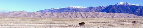
I would be very interested in hearing more about Great Sand Dunes. I would like to take a trip there some day. I don't know much about it yet, but it looks awesome.

Chris
 
Wikipedia info.
http://en.wikipedia.org/wiki/Great_Sand_Dunes_National_Park_and_Preserve

GreatSandDunesNP_ETM_14oct1999.jpg


Dunes_great_sand_2.jpg

The dunes — 750 feet (230 m) tall — at the base of the Sangre de Cristo Range.

750ft tall!!! Thats about 200ft higher than the highest point in Louisiana! :D

I remember the Sand Dunes from my previous visit. I also remember not being able to climb them because of a lightening/ hail storm. I hope to climb it one day. I hope to climb some dunes in the Sahara first.
 

bbls

New member
Brings a tear to my eye. I spent many years in Colorado. What a wonderful place to experience the awesome glory of nature.


May your focus be on the journey, not the destination.
 

Martinjmpr

Wiffleball Batter
When was this trip? Looks like it was very early or very late in the year.

Anyone planning a 4-wheeling trip to CO needs to understand the climate here. Especially if they are planning on hitting any of the higher passes. Most of the 10,000'+ passes are only open from late June to mid September. Some of the higher trails don't open until August and in a heavy snow year some trails will remain closed all year (last time I tried to run Mosquito Pass it was closed due to a 300' snowdrift along the shelf road. This was in mid-August.)

Even now, I can tell you that Red Cone (12,000') is covered with snow, as is Webster Pass. In fact, AFAIK none of the Summit County trails are open as of yet. Arapahoe Basin Ski Area only closed about 3 weeks ago.

Medano is typically open between about Memorial Day and mid to late September, or even early October (first snows are usually light and don't close the trails.) With Medano you also have to be careful because of the numerous water crossings. Even when the trail is open the water crossings may make it impassable at times as the spring runoff commences.

From Mid-October to Mid-June, you pretty much have to plan on just hitting the dirt roads and the lower elevation trails. Actually, that's a good time to do Moab or the Southeastern Utah trails because in Summer it's hotter than hell there.

For those wondering Phantom Canyon road runs between the old mining (and modern gambling) town of Cripple Creek and Canon City, on the Arkansas River.
 
We ate our Thanksgiving meal on the road somewhere around Victor.... that was last year.

I knew it was unlikely that the trails would be open when we got there.... but like I said, we had intended to drive to Mexico...
 

Martinjmpr

Wiffleball Batter
LaOutbackTrail said:
We ate our Thanksgiving meal on the road somewhere around Victor.... that was last year.

I knew it was unlikely that the trails would be open when we got there.... but like I said, we had intended to drive to Mexico...

Ah, that explains it. Yes, by late November most of the higher trails are closed.

This past year they even closed Rampart Range Road which is a well graded dirt road at moderate elevation (about 7500'.)

The formal closing (and gating) of roads/trails is something I've seen more and more of over the last 25 years or so (I've lived in CO since 1972.)

Many of the roads/trails in CO are closed by the FS or by the counties for preventative reasons. IOW, they are closed because often times people would go up there with no understanding of just how quickly it can go from pleasant and sunny to blizzard conditions, and they were having to do a lot of rescues of people who should have known better. Eventually it became easier to just gate the roads and close them for the season.

I'm hoping to do some of the trails in Southern CO this Summer, but I don't plan on hitting them until late July at the earliest!
 

bbls

New member
An addition for those wondering, Shelf Road also runs south out of Cripple Creek and is a little more isolated and interesting. Phantom Canyon can become like a freeway in the summer.
 
bbls said:
An addition for those wondering, Shelf Road also runs south out of Cripple Creek and is a little more isolated and interesting. Phantom Canyon can become like a freeway in the summer.

Yep, we were considering shelf road also. When we got to Victor, we asked the conditions of both roads and shelf road had a good bit of ice on it that hadnt melted and the 10 or so old folks in the little restaurant strongly recommended NOT going on Shelf road, but that they had several people stop by coming out of Phantom Canyon.

If you are in Canon City for a few days, up Shelf Road to Cripple Creek to Victor and back to Canon City on Phantom Canyon rd is a good loop, i understand.

Oh and about PC rd becoming a freeway... we passed one vehicle in victor coming out of PC. We also saw one vehicle, the owner fishing, about 3/4 of the way through on the south end of PC. No vehicles while we were driving.
 
Martinjmpr said:
Ah, that explains it. Yes, by late November most of the higher trails are closed.

This past year they even closed Rampart Range Road which is a well graded dirt road at moderate elevation (about 7500'.)

The formal closing (and gating) of roads/trails is something I've seen more and more of over the last 25 years or so (I've lived in CO since 1972.)

Many of the roads/trails in CO are closed by the FS or by the counties for preventative reasons. IOW, they are closed because often times people would go up there with no understanding of just how quickly it can go from pleasant and sunny to blizzard conditions, and they were having to do a lot of rescues of people who should have known better. Eventually it became easier to just gate the roads and close them for the season.

I'm hoping to do some of the trails in Southern CO this Summer, but I don't plan on hitting them until late July at the earliest!

We called the park ranger at Great Sand Dunes the day before we wanted to do Medano Pass. He said as long as no major snow came in, it would be possible and easy. Tha night was when the snow came in. Called that morning and the Ranger said that its not closed but that they were going to shut the gate on my side of the mountain that the snow was building up... this was when we left Canon City and starting to get snowed on.... which, by the time we left was already 1" accumulation.

I've got a pretty good head on my shoulders. I had been watching the weather patterns and get local/professional advice before I put my family in danger. BUT, we did have cold weather camping gear and plenty of food... so we would have been good for a couple of days. I wouldnt (and didnt) put them in danger by attempting Medano Pass in near white out conditions.

It was one of the passes that I did want to do really badly. It would have been more fun than going all the way around to Salida and then down.
 

Forum statistics

Threads
189,829
Messages
2,921,379
Members
232,931
Latest member
Northandfree
Top