Sirocco
Explorer
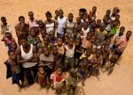
I have started to put my trip report together for our recently completed expedition across Burkina Faso - Mali - Senegal for the MAPA Project. MAPA are mapping national parks, reserves and conservation projects across africa to help promote their existance and conservation. We were fortunate enough to be given one of their Land Cruiser 105s for 5 weeks and a schedule for 7 national parks in West Africa. We drove over 6500km mapping some very remote regions and meeting very remote people, it was a fantastic experience. The report is not complete yet, I will add this as another post as it gets done along with photos. For the full photo album you can see these on Facebook, just search: Sirocco Overland. wwwSiroccoverland.com is also our website where photos and this report will be stored once completed.
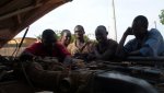
As darkness fell I was scrabbling around on the floor underneath the 105 trying to locate the origin of the high flowing fuel leak emanating from the main tank. With the beam from my Petzl head torch I could see the stream of petrol arcing like an ornamental fountain away from the top of the tank, this was going to be tough to get to but even tougher to try and remedy a repair.
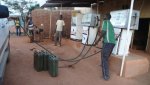
Moments earlier we had filled up both fuel tanks after arriving on vapour, to add complexity we were having engine trouble which was causing a lack of power and eventual halt for 5 minutes every 5 minutes. We were 200Km south of Oaugadougou in Burkina Faso, less than 5 days in. This was not how I envisaged my five weeks mapping National Parks for the MAPA Project.
Background
The MAPA Project (Mapping Africa's Protected Areas) has been doing its thing around the south and east of the continent whilst I was busy driving around Morocco in 2008. It wasn't until Late August 2010 that I spotted a thread on the Expedition Portal notifying that they were doing the same for West Africa and looking for volunteers. I had not spotted the update for a number of months, but thought it worth getting an application in. This time around MAPA decided entrants needed to be in pairs to ensure compatibility. This being the case I needed a good friend who could take five weeks off with little notice, wanted to travel through some of the most politically unstable and corrupt countries of the world working voluntarily at the same time. Bush mechanics, a foreign tongue, medical knowledge, 4x4 driving skills, technical savvy and a thirst for outdoor living were all desirable extras.
Emails went around some of my more experienced overland travelling friends but the response was a disappointing and resounding no. I put the trip out of my mind. Two weeks later I got a call from my friend Peter who we met in Morocco, he had reconsidered. We promptly put our applications in and weeks went by without even a notification. A quick email to March Turnbull (MAPA Director) proved he had not only received our applications, but put us on the first reserve list. “Is that OK?” Absolutely! A month went by, an opportunity came up, but Peter Was in Namibia with his 110! we had to say no. By the end of November something else had come up, MAPA had a 3 month stint to fill. We put in for mid-March to mid-April, Peter was back and it straddled the holiday year for us both meaning time off would be easier... or so I thought. Routes were planned, flights looked at, but celebration didn't last long as Peter soon found out he could not get the full five weeks off work. It was complicated, we looked at our options but there was no solution, I had to find someone else... fast.
By February the project was coming to a close as teams had been mapping east to west from Cameroon. The troubles in the Ivory Coast before Christmas changed the route as it removed a vital link south along the coast, parks in northern Mali and Niger were crossed off the list due to the recent kidnappings and murders of westerners by AQIM (Al-Quaeda Organisation in the Islamic Maghreb). Coupled with the possibility of not getting into Guinea due to land border closures (ongoing military coup) MAPAs time in West Africa was getting shorter. With the other team two weeks ahead of us it was decided that they would route to Guinea (if possible) through Sierra Leone and onto Liberia, making their way back to Guinea Bissau and through to Dakar in Senegal, the final meeting point. Our countries would be Burkina Faso, Mali, Senegal and possibly Gambia. We would see how we got on. With only five weeks to go and nobody lined up I honestly didn't think I would be going anywhere. Discussions with a friend at work showed he was keen, but quitting your long term employment for a short duration volunteer project is a bold move. Luckily one that Simon was happy to make. The four week countdown vanished and before we knew it we had our Visas, yellow fever certificates, flight tickets and I was bidding farewell to Lisa on the tarmac of Bristol Airport... our adventure had begun.
Burkina Faso
Touching down in Ouaga (Ouagadougou) 1630 the air temperature on opening the cabin doors was a relentless 42°c. Checking our visa and yellow fever certificate were in order and a quick rustle of the bags we cleared customs. The airport lies on the edge of the city just a ten minute taxi ride from the centre. From the air Ouaga is a small capital city, dusty, dirty and very busy, much what we expected. Our accomodation was the Hotel Delwende where we made plans to pick up the truck and start organising things for the coming five weeks of mapping.

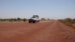
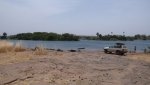
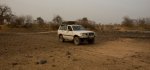
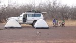
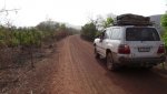
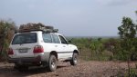
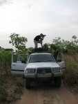
Our truck for was a 2000MY Toyota Land Cruiser 105, the stripped out bare version of the rest of world (ROW) 100 series. South African registered right hand drive it unfortunately had the 4.5L straight 6 petrol engine (1FZ for 'yota aficionados). Thirsty? How does 14mpg (5km/litre) sound? Not to worry we had 2 fuel tank topping 120 litres and afurther three nato jerry cans. Fuel worries aside (for now) we had a 50 litre inbuilt water tank, solar panel battery charger, braii grill, 9.5k winch, awning and the legendary MT45 Engel fridge.


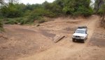
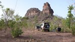
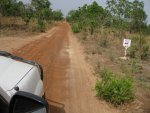
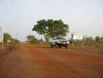
After picking up our Malian visas and an assortment of food we headed south filled with excitement and anticipation of our first park. When your new in country you need a little time to adjust to your surroundings, the climate, language difficulties but more importantly for overlander's are road conditions. Driving into po´ after six hours of diversions, potholes, corrugations, dirt roads and toll booths we couldn't find the piste we needed to get to Nazinga Ranch. We drove through po´ down to the Ghana border. Back to po´ we missed the junction three or four times. Asking locals proved fruitless as we would discover a lot on this trip, not many people had heard of the National Parks. As we approached our last option a few of the graders doing roadworks on the main drag moved forward revealing a sign, 'Leo'. Making our way through the ramshackle market the dirt road soon opened out to the piste and we were on our way to Nazinga Ranch, we had only wasted some three hours...
MAPA Project Volunteer Trip to the Heart of West Africa 2011
As darkness fell I was scrabbling around on the floor underneath the 105 trying to locate the origin of the high flowing fuel leak emanating from the main tank. With the beam from my Petzl head torch I could see the stream of petrol arcing like an ornamental fountain away from the top of the tank, this was going to be tough to get to but even tougher to try and remedy a repair.
Moments earlier we had filled up both fuel tanks after arriving on vapour, to add complexity we were having engine trouble which was causing a lack of power and eventual halt for 5 minutes every 5 minutes. We were 200Km south of Oaugadougou in Burkina Faso, less than 5 days in. This was not how I envisaged my five weeks mapping National Parks for the MAPA Project.
Background
The MAPA Project (Mapping Africa's Protected Areas) has been doing its thing around the south and east of the continent whilst I was busy driving around Morocco in 2008. It wasn't until Late August 2010 that I spotted a thread on the Expedition Portal notifying that they were doing the same for West Africa and looking for volunteers. I had not spotted the update for a number of months, but thought it worth getting an application in. This time around MAPA decided entrants needed to be in pairs to ensure compatibility. This being the case I needed a good friend who could take five weeks off with little notice, wanted to travel through some of the most politically unstable and corrupt countries of the world working voluntarily at the same time. Bush mechanics, a foreign tongue, medical knowledge, 4x4 driving skills, technical savvy and a thirst for outdoor living were all desirable extras.
Emails went around some of my more experienced overland travelling friends but the response was a disappointing and resounding no. I put the trip out of my mind. Two weeks later I got a call from my friend Peter who we met in Morocco, he had reconsidered. We promptly put our applications in and weeks went by without even a notification. A quick email to March Turnbull (MAPA Director) proved he had not only received our applications, but put us on the first reserve list. “Is that OK?” Absolutely! A month went by, an opportunity came up, but Peter Was in Namibia with his 110! we had to say no. By the end of November something else had come up, MAPA had a 3 month stint to fill. We put in for mid-March to mid-April, Peter was back and it straddled the holiday year for us both meaning time off would be easier... or so I thought. Routes were planned, flights looked at, but celebration didn't last long as Peter soon found out he could not get the full five weeks off work. It was complicated, we looked at our options but there was no solution, I had to find someone else... fast.
By February the project was coming to a close as teams had been mapping east to west from Cameroon. The troubles in the Ivory Coast before Christmas changed the route as it removed a vital link south along the coast, parks in northern Mali and Niger were crossed off the list due to the recent kidnappings and murders of westerners by AQIM (Al-Quaeda Organisation in the Islamic Maghreb). Coupled with the possibility of not getting into Guinea due to land border closures (ongoing military coup) MAPAs time in West Africa was getting shorter. With the other team two weeks ahead of us it was decided that they would route to Guinea (if possible) through Sierra Leone and onto Liberia, making their way back to Guinea Bissau and through to Dakar in Senegal, the final meeting point. Our countries would be Burkina Faso, Mali, Senegal and possibly Gambia. We would see how we got on. With only five weeks to go and nobody lined up I honestly didn't think I would be going anywhere. Discussions with a friend at work showed he was keen, but quitting your long term employment for a short duration volunteer project is a bold move. Luckily one that Simon was happy to make. The four week countdown vanished and before we knew it we had our Visas, yellow fever certificates, flight tickets and I was bidding farewell to Lisa on the tarmac of Bristol Airport... our adventure had begun.
Burkina Faso
Touching down in Ouaga (Ouagadougou) 1630 the air temperature on opening the cabin doors was a relentless 42°c. Checking our visa and yellow fever certificate were in order and a quick rustle of the bags we cleared customs. The airport lies on the edge of the city just a ten minute taxi ride from the centre. From the air Ouaga is a small capital city, dusty, dirty and very busy, much what we expected. Our accomodation was the Hotel Delwende where we made plans to pick up the truck and start organising things for the coming five weeks of mapping.
Our truck for was a 2000MY Toyota Land Cruiser 105, the stripped out bare version of the rest of world (ROW) 100 series. South African registered right hand drive it unfortunately had the 4.5L straight 6 petrol engine (1FZ for 'yota aficionados). Thirsty? How does 14mpg (5km/litre) sound? Not to worry we had 2 fuel tank topping 120 litres and afurther three nato jerry cans. Fuel worries aside (for now) we had a 50 litre inbuilt water tank, solar panel battery charger, braii grill, 9.5k winch, awning and the legendary MT45 Engel fridge.
After picking up our Malian visas and an assortment of food we headed south filled with excitement and anticipation of our first park. When your new in country you need a little time to adjust to your surroundings, the climate, language difficulties but more importantly for overlander's are road conditions. Driving into po´ after six hours of diversions, potholes, corrugations, dirt roads and toll booths we couldn't find the piste we needed to get to Nazinga Ranch. We drove through po´ down to the Ghana border. Back to po´ we missed the junction three or four times. Asking locals proved fruitless as we would discover a lot on this trip, not many people had heard of the National Parks. As we approached our last option a few of the graders doing roadworks on the main drag moved forward revealing a sign, 'Leo'. Making our way through the ramshackle market the dirt road soon opened out to the piste and we were on our way to Nazinga Ranch, we had only wasted some three hours...
Attachments
Last edited:
 I have it back again now and just need to complete the Senegal section. I will add photos to this post when I return home and have proper internet.