StayTheTrail
New member
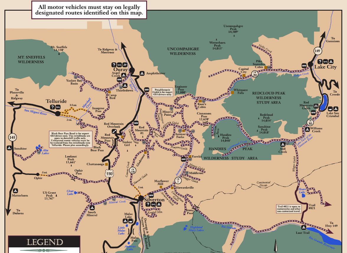
For years now, Stay The Trail has hosted Motor Vehicle Use Maps (MVUMs) and overlaid them in the Google mapping system. We consistently were asked if there was a solution to easily utilize these maps on a handheld smartphone or tablet. The day has finally come...free MVUM mobile mapping is here.
Stay the Trail Colorado provides a central webpage where the public, organizations and agencies can download all US Forest Service Motor Vehicle Use Maps (MVUM) for National Forests and Grasslands located in Colorado. These maps are kept up to date as the US Forest Service updates their maps. Funding for this effort is provided by Colorado Parks and Wildlife in the form of grant funding that comes from registration of OHVs in Colorado.
Stay the Trail and Great Outdoors Consultants have made the MVUMs “smarter” by making sure they all have geospatial information (the map knows where it’s located in the World) and by providing them in multiple formats. Smart MVUMs are provided in the following formats.
Geospatial PDF Files
Some National Forests are publishing PDF versions of MVUMs that are already geospatial which means that you can see map coordinates in Acrobat Reader using the geospatial location tool (found in the analysis toolbar/ menu). These maps can also be imported into some mapping programs such as Global Mapper. MVUMs that did not have geospatial information were processed to add geospatial information using Global Mapper software. All PDF MVUMs were exported in the following coordinate system: UTM – Zone 13 North – NAD1983 - meters
Geospatial PDFs can also be used on Apple and Android smart phones/tablets using Avenza’s free application called PDF Maps.
View attachment 152490
After the PDF MVUM is downloaded on the mobile device, cellular coverage is not needed to use it. This application shows the current GPS location of the user on the map and allows them to perform some basic GPS recording tasks! The application allows you to show the location of geotagged photos you’ve taken with your mobile device right on the MVUM map. PDF Maps has an online map store that allows users of the app to find MVUMs by name or their current location! This app is being used to distribute free maps for the National Park Service, USGS Topo maps and other free maps. The store also allows for sale of commercial maps such as National Geographic maps. All MVUMs found on the Stay the Trail webpage are now also available through the Avenza map store for free!
1. Go to “App Store”, search for “PDF Maps” and install
2. Open “PDF Maps”, select “Store” function from the lower bar
3. Select the search function in top right corner.
4. Search for “Stay The Trail” or “MVUM” or a Ranger District, select from the pins that appear
5. Use the “Free” button to download to the phone.
6. Downloaded maps show up in the “Maps” list on the lower left
7. Select appropriate map for the district’s trails you will be using. Your location appears using GPS sensor.
Note: The android version of the PDF Maps app is a beta version and is not currently linked to the Avenza map store. Maps can be loaded in the Android version by linking to the Stay the Trail webpage MVUMs, by emailing the PDF file or a link to it.
Weblinks:
http://staythetrail.org/mvum/index.php - All Colorado PDF MVUMs on one webpage
http://www.avenza.com/pdf-maps - information about the application
http://www.pdf-maps.com/get-maps - search for Colorado MVUMs on your computer – preview only
Google Earth Files
Geospatial PDF MVUM files were rasterized in Global Mapper software and then clipped to the map frame (excluded the legend). The rasterized MVUM files were then exported to Google Earth .kmz files. These files can be loaded into Google Earth desktop and mobile applications. To load a .kmz file on your mobile device, email yourself the appropriate .kmz file or a link to the .kmz file on the Stay the Trail webpage. Google Earth mobile will show your current location on the MVUMs. MVUMs in this format allow the user to load adjacent MVUMs and look at them in 3D. Google Earth also allows the user to add other vector data on top of the MVUM such as trails or other data they have. A brief description of the MVUM file and a link to the Stay the Trail webpage are included in the .kmz files so the user can access the legend and other information that has been removed from the .kmz version of the MVUMs. All Google Earth MVUMs were exported in the following coordinate system: Latitude-Longitude - WGS84 - decimal degrees.
Weblink:
http://www.staythetrail.org/mvum/kmz/ - All Colorado Google Earth MVUMs on one webpage
Geotiff Files
Geospatial PDF MVUM files were rasterized in Global Mapper software and then clipped to the map frame (excluded the legend). The rasterized MVUM files were then exported to geotiff (.tif) files. Geotiffs are raster files that include geospatial information. These files can be loaded into Arcmap, Global Mapper, Terrasync, Arcpad and other GIS/GPS programs. They can also be loaded into Avenza PDF Maps mobile application! MVUMs in this format allow the user to load adjacent MVUMs and look at them side-by-side. GIS programs allow the user to add other vector data on top of the MVUM such as trails or other data. A brief description of the MVUM file and a link to the Stay the Trail webpage are included as text files so the user can access the legend and other information that has been removed from the .tif version of the MVUMs. All geotiff MVUMs were exported in the following coordinate system: UTM – Zone 13 North – NAD1983 - meters.
Weblink:
http://www.staythetrail.org/mvum/geotiff/ - All Colorado Geotiff MVUMs on one webpage