New Zealand Vagabonds

elcoyote

Supporting Sponsor, Overland Certified OC0004
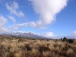
We’ve come to the conclusion that there it is not possible to see what NZ has to offer in only 3 weeks. We have read travelogues of people who have done almost all of the major routes on both islands in 3 weeks. We now know that they probably spent 8 or more hours a day behind the wheel and never really got to experience the land and people of the Kiwi. We originally thought that we might drive 300 km per day but have found that 150 km or less provides a better experience. Stopping to get out to walk a bit though a township, meeting a few local folks, soaking in at a hot spring, having a brew in a local pub are not things you can do with your foot to the floor conspicuously consuming hydrocarbons. I like to drive but there is too much to see here. At every turn in the road, there is a new site to behold. Out of the corner of my eye as we drive, I can see rough dirt tracks climbing steep mountains and disappearing into the bush. The map book we are traveling with shows 4 wheel drive tracks everywhere. They tease me… we are already talking about coming back at a future date, possibly sending our 4x4 over and hitting the less traveled tracks.

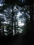
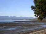
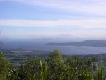
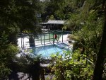
We split Kaikoura and headed south to Peketa Beach where we pulled into the local campground at sunset to spend the night. The surf was pounding here with waves from the mighty Pacific. The next morning we decided to head over the mountains through alpine country on our way to the West Coast of the South Island via hwys 70 and 7. We had decided that there was no way that we could make it all the way to Milford Sound or Invercargil and continue the same level of enjoyment…time to slow down. We had read about the famous thermal pools of Hanmer Springs and thought a good soak was in order. We arrived in the town centre to be sorrowfully disappointed at how commercial it was. We were turned off by its canned “Adventure” experiences such as paint ball, bungy jumping and jet boating. People were everywhere, waiting in lines to be herded onto busses to go jump off of something and collect a T shirt. The South Island has so few people that it was weird to see so many crammed into a small place. It did not inspire us to stay any longer than it took us to buy a coffee and scone at the local bakery.

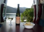
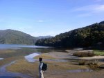
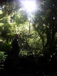
A spot on the map called to us, Maruia Springs. We were on a quest for a nice quiet soak. We found it! Maruia Springs is a small isolated thermal springs resort tucked away in the Victoria Forest. The Japanese style resort is very beautiful and restful. Our private pool, with its surrounding heated floor, was in a cedar hut with a view of the mountains and the Grey River. A few klicks down the road from the springs we found Slab Creek DOC camp; the site of a former gold mining area and now a recreational gold panning spot (which is called “Fossicking” in NZ). We spent the night next to the sound of the babbling stream, reading aloud from our adventure novel for the road, “The Skeletons of the Zahara”, a true tale of extreme hardship & slavery on the hot dry sands of the Sahara in 1815, read ironically on a misty cool night in the NZ bush.
 

jeffryscott

2006 Rally Course Champion: Expedition Trophy
I finally caught up on this adventure, it sounds simply amazing. The wine, the cheese, the countryside and the locals ... what a spectacular trip. Thanks for keeping us in mind and sharing.

Jeff
 

haven

Expedition Leader
its a weka

Regarding the bird photo, I think that's a Weka, Gallirallus australis, a kind of flightless rail. It's endangered on the North Island, and only locally common on the South Island.

New Zealand's avifauna has an unusually large number of flightless birds, including the iconic Kiwi. The explanation usually offered is that mammal ground predators did not evolve on New Zealand's islands. Being able to fly away for defense gave no advantage to birds that find their food on the ground. So over the course of millions of years, a number of bird species gave up their ability to fly.

Unfortunately, the arrival of Europeans changed the game. Rats and feral cats are a real threat to the survival of flightless birds.

Chip Haven
 

articulate

Expedition Leader
elcoyote said:
Could it possibly have happened? Yep it did, we’re sick of Sauvignon Blanc….well, nearly.
Yikes. You drank 'till you were sick? That's unheard of.

I'm digging your pcitures and tales. :)
 

Ridgewalker

Adventurer
Oh I want to go back! The wine (as I recall) was such a bargain and so good since it never travelled.:wings:
Have you tried the Red Deer?:chowtime: You see them commercially raised in high fenced pens everywhere.
You are so lucky!
 

elcoyote

Supporting Sponsor, Overland Certified OC0004
Whew! Lots to write about since our last entry. Sorry for the long delay, this is going to be a long one. We’ve just quite frankly been having way too much fun and not taking the time to write. Tonight is different though, well rested after a day of soaking in thermal pools and massages…more on that later.

At last post we were camped in the Victoria Forest Park on the South Island. We awoke to light rain and fog. We headed south on SH7 towards Greymouth on the west coast. I had in my mind that there was a drinking establishment called “Formerly the Blackball Hilton” but as it turned out that was in Blackball, not Greymouth…go figure. The route was beautiful as it followed the Greymouth River from Reefton to the coast through grazing land and since abandoned coal mines. The river gained girth as we followed it, finally emptying into the Tasman Sea in the town of its namesake. Being Sunday, the town was closed up tight except for the local Countdown Market and Shell station; just what we needed. We tried to find an internet connection only to wait 45 mins for a toasted bagel at the local espresso bar and find out their connection was down…bummer, but no worries, our travels were not yet over for the day.

We headed north along the coast on SH67 with a full tank and fresh provisions, the town of Westport in our sights. This is a spectacular section of coastline…okay it’s all spectacular but each day in NZ is just an incredible visual feast that you can no longer tell if you like one place more than another. Anyhow, tootling along SH67 as I was saying, we skirted Paparoa National Park. Again, the bush is lush, growing right up to the breakers where not abated by mans’ trimming machinery. This whole stretch of coastal drive were are pelted by rain. On the road we spot a sign that reads: “Want Switzerland, see Queensland. Want New Zealand, see Westport”.

The sleepy town of Westport, just west of Cape Foulwind (appropriately named given the days weather) was established as a fishing and coal mining town but the latter business ceased in 1997. Once in Westport, the lady who runs the local Holiday Park tells us that one of the few places in town open on a Sunday is the Denniston Dog Licensed Café. In NZ, a “Café” serves food. A “Licensed” establishment serves food & alcohol. After a quick loop through this town of perhaps no more than a few thousand and the working marina, we find the Denniston. The place is inviting with its coal fired stove, warmly painted décor, pictures of local people and historical tools on the wall. They’ve got a pool table and e-mail terminal. I am reminded of something that Martyn said who had spent a year in NZ, “No matter how small the town in NZ, you’ll find a good place to eat”. A few glasses of wine and Speights’ Gold (a South Island brew) later, we are dining on red wine marinated venison and turbot with a lemon cream sauce and French lentils. Life is good.

In the morning we are reminded of one of our few commitments while in NZ: our return ferry crossing to the North Island. We’ve got some tracks to make to be in Picton on our departure date. We decide to make a driving day of it on SH6 and hit Nelson by afternoon with hopefully enough time to walk around town. Nelson we found to be quite busy. It serves as a gateway to tourism on the famous Tasman Bay and surrounding sounds. In the city centre is an ugly building in Trafalgar square that the locals say would only look better if the architect was hanging from its parapets…tough audience. While in Nelson, by some internal compass, I was drawn to the local Toyota dealer who was featuring the new BJ70 UTE with a 4.5 liter V8 turbo diesel and factory snorkel. Wow! Now I know that NZ is considered a forward thinking and progressive country but I had no idea that they would flagrantly allow such XXX rated porn to be displayed in public. Have they no shame? Nonetheless, I grabbed a brochure to read in a more private setting ;)

Nelson, the busy town it is, didn’t feel right as a place to spend the night given our good fortune for finding cool secluded camp sites. At dark, we decided to head north on SH60 towards Motueka to a Holiday Park listed in our travel guide. It was so bad that I am at a loss what it was called now. We poked around in the dark some more on SH60 until we spotted McFee Memorial Park along the water at Ruby Bay with the lights of Nelson across the bay. Shall I say, serendipity no less with the sounds of the gentle surf lapping at the rear door of the van….Zzzzzzzzzzz

In the morning we left Motueka and back tracked a bit to get to Havelock where we hoped to get in some walking along the sounds. We arrived around noon and it was time to indulge in NZs’ Mussell Capital of the World for lunch. Personally I think that with enough white wine, garlic and butter you can make an old shoe palatable. The mussels were superfluous and Anne had Blue Cod served on fresh greens. With fresh fuel in our bellies, we were ready to walk. We found the trailhead of Queen Charlotte’s walking track at the end of the road next to the Outward Bound School. This walk through NZs’ finest bush along the sounds is not to be missed. We only went about an hour in to Davies Bay and watched as birds fished for mollusks and other yummies along the calm shore. It is possible to spend several days along this path arranging for water taxis to pick up and drop off at various DOC sites along the way. Pretty high class when it comes to backpacking in my opinion

Since we were due to be on the ferry early, we headed off in search of a place for happy hour and camp for the night. We found refuge at Aussie Bay, a small almost unnoticeable DOC beach down a steep dirt access path along Queen Charlotte Scenic Drive. The spot was a little sloppy with mud from recent rain and required a bit of maneuvering with our 2wd van but we placed the doors just right and opened them out onto a fantastic view of the bay through the bush.

At 1AM we are awakened to heavy rain. Ocean squall type rain. First thought on our minds was if we were going to get enough traction with the van to get out. Yipes, we can’t miss the ferry. All hands on deck! We get the van back into driving mode and turn the diesel over. I let her warm up a so as not to risk a stall. The rain is coming down in sheets. The evening before I had strategically placed some branches in the muddiest of sections to aid in traction. We ride through those but cannot get enough momentum or traction to climb the slippery right handed slope onto the paved road. No good. In my groggy state, I realize that the only way to place the right rear tire on a good grippy surface is to turn left down the hill, the opposite direction of where we want to go and then with some good aim and momentum, back the rear tire onto the paved section. It works! With the tires spinning crazily but making headway, we grind our way back up the slope onto the main road backwards. Okay, that’s done but it’s still the wee hours so we find a nice level, well paved picnic ground clearly posted “No Camping” with a couple of other rain refugee camper vans in it and grab a few more winks of shut eye before our crossing.

We wake at 6 AM, it’s still pissing rain sideways. We decide to inch our way along the narrow Queen Charlotte Drive to Picton and see if we can find out if the ferry will sail in this weather and if we even want to be on board. The locals at the bakery over coffee & savouries assure us that its’ a southerly westerly warm condition thing and that’s good. The northerly easterly cold thing is bad. “No worries” they assure so we go and queue up for the ferry. We are skeptical as we wade our way to the wharf with wipers on full speed. We’re first in line and like some miracle, when it’s time to load all of the autos, rail cars and livestock laden semi trucks on board, the weather clears. Its’ 100% New Zealand.
 

Attachments

  • Aussie Bay Happy HourLO.JPG
    Aussie Bay Happy HourLO.JPG
    128.8 KB · Views: 43
  • Davies Bay AnneLO.JPG
    Davies Bay AnneLO.JPG
    178.5 KB · Views: 39
  • Davies Bay Bird Fish LO.JPG
    Davies Bay Bird Fish LO.JPG
    326.9 KB · Views: 34
  • LC 70 4.5 TD V8-2LO.JPG
    LC 70 4.5 TD V8-2LO.JPG
    188.6 KB · Views: 44
  • LC 70 used 4.2 TDLO.JPG
    LC 70 used 4.2 TDLO.JPG
    97.5 KB · Views: 43
  • Charlotte Bush WalkLO.JPG
    Charlotte Bush WalkLO.JPG
    297.7 KB · Views: 27
  • McFeeLO.JPG
    McFeeLO.JPG
    224.3 KB · Views: 22
  • LC 70LO.JPG
    LC 70LO.JPG
    99.3 KB · Views: 38

elcoyote

Supporting Sponsor, Overland Certified OC0004
Our ferry crossing despite the inclement weather is fairly uneventful, cruising across the straight with a good starboard heel on due to the wind. You’ve got to love these modern ferries with restaurants, movies theaters, bars and of course, stabilizer systems.

We dock at 1:30 PM with not many hours left in the day to make our destination. Since the ferry ran late, we decided to forgo visiting Wanagnui on the west coast of the North Island and try to get as close to Lake Taupo on SH1 as possible. This large volcanic crater lake is the largest in NZ. I don’t know the numbers exactly but it appears to be as large as Tahoe.

SH1 is the major artery running north/south through the North Island. It is a well maintained 2 lane road (one in each direction). As we head north out of Wellington, we cruise through several beach towns such as Pakerua, Paekakariki, Paraparaumu, Waiarere, Waikawa, Himatangi and others with far too many syllables for us to catch as the road signs wiz by. The recent weather has whipped the surf into a dramatic froth. The west coast of the North Island is a mecca for surfers and there are a few crazies out there trying to catch a wave on this day of gale force winds.

We stopped in the hamlet of Huntersville, the home and capital of the NZ Huntaway dog. Being a dog person, I looked this beast up and as it turns out, the dog is rather a mutt as from the pictures I could see that no two looked alike. Kiwis pride themselves on these hard working farm dogs and we got a chance to see a group of them in action. We were stopped along the road by a herd of cattle being moved along the highway from one grazing field to another. As we waited, 3 ranch hands stood by with their hands in their pockets as the dogs guided the beasts though one gate down the short stretch of highway and through another gate, all that for a good scratch behind the ear. They obediently hopped back into their mobile kennel being towed by the ranch hands quad. Ooh to be a dog 

Given our long day of travel and lack of sleep the night before, we cut our travels short at the village of Taihape where we found yet another immaculate motor park. Ray who ran the place along with his wife, talked a bit about spending some time in Wyoming as a sheep shearer. Apparently the business of sheep in NZ is on the downturn due to synthetic fibers and he had turned to running a motorcamp instead. Sheep once numbered 60 million to the 3 million inhabitants. That has changed to 40 million sheep to 4 million inhabitants.

The following day we made the short trek to Taupo via the “Desert Road”. It is desert in NZ sense of the terms but quite small in our realm of experience. It reminds us of high desert scrub on the Coconino Plateau in AZ but minus the juniper and piňon trees. Mt Ruapehu reigns in the distance. NZ trains its army here just like we do in our deserts. The road is bordered by signs warning of explosions and live fire. The only evidence we see of military activity is two Unimogs on the highway. Once through the desert, we enter lush bush again and stop at the Tongariro National Trout Centre. This is the largest fish hatchery in NZ on the Tongariro River. The centre is in a bush setting with a self guided walk of the hatchery, a small museum, an underwater viewing area of fish on the river and of course, a nice walking path on the river that they will let you fish from  I am a little disheartened by the fact that they only allow fly fishing and not lure fishing mostly because I suck as a fly fisherman  I guess I’ll have to get Scotty to whip me into shape when we return.

Quickly scanning through our numerous guides, we discover that the Taupo Springs Resort has a campground to boot. We decide to check it out only to discover that it is fabulous. Immaculately kept, walking distance down the hill to their thermal pools, private tubs etc and heck, they even have wifi. If you’re ever in this area, this place should be at the top of your list in the R&R department. We settle in and arrange for massages for the next day. We spent the afternoon in pedestrian friendly central Taupo. It's quaint and full of cafes. An Artful place, right down to their fanciful trash cans!

Two days spent in Taupo, soaking. Ahhhhhhh…..Our first day we paid for some traditional acupressure type massages but the next day, to our good fortune, we made friends with a couple of massage therapists who were having a “Convention” of practitioners of Watsu, a water based massage modiality where you float in the hands of the therapist and your body is manipulated in the near weightlessness of the water. We lucked out when they asked us if we’d like to experience this, just as an offer of kindness. It was an awesome bodywork experience. You’ve got to love Kiwi hospitality! You can check out their site at www.sacredplay.co.nz

Later in the day we decided to get in some strenuous exercise to compensate for all the pampering by taking a bush walk to the summit of cloud enshrouded Mt. Tauhara. This was a true bush walk as we filed through a thin slice of cleared vegetation and heavy mist. The weather cleared just long enough at the summit to watch a couple of gliders climb up from the valley floor on the thermals and buzz over our heads by no more than 100 ft. They were close enough for us to hear the wind running over their wings. All this and a grand vista of Lake Taupo to boot. Another good day down under indeed.

Our trip is nearing its end. We have two days to make it back to Auckland, just a mere 280 kms. I am not sure but our next post may be from Auckland just prior to getting wheels up or it will bean epilogue filed from home. In any event, we’ll check in again to bring this thread to a close.

Until then, enjoy this pictures and be good y’all!
 

Attachments

  • Taupo Trash canLO.JPG
    Taupo Trash canLO.JPG
    227.6 KB · Views: 41
  • MtTuaharaBushTrailLO.JPG
    MtTuaharaBushTrailLO.JPG
    249.5 KB · Views: 29
  • Mt RuapehuLO.JPG
    Mt RuapehuLO.JPG
    128.4 KB · Views: 29
  • TaupoLO.JPG
    TaupoLO.JPG
    152.4 KB · Views: 26
  • Trout 4LO.JPG
    Trout 4LO.JPG
    43.3 KB · Views: 32
  • Trout HatchLO.JPG
    Trout HatchLO.JPG
    162.7 KB · Views: 42
Last edited:

elcoyote

Supporting Sponsor, Overland Certified OC0004
We determined that we should start our two day return trek to Auckland to catch our flight home by 10:00 Saturday morning 5/26… At 10:30, enjoying our last morning soak in the Taupo Hot pools, I am suddenly struck that I am not ready to leave this place. Anne & I look at each other and quickly calculate that we can stay another day here if we elect to get pre-dawn start on Monday and drive the distance in one push. It was an easy vote! We settle in for another day of soaking in waters and lush surroundings at Taupo.

Monday 4:30 AM rolls around rudely. We are fed & watered and on the road by 5:30. Our trip to Auckland is a gentle easing back into urban surrounds as grazing land and bush becomes more & more interspersed with human settlement. Fortunately we are not headed directly into downtown, only to Papakura, just south of the city. We arrive at NZ Frontiers at our required noon check in to be greeted by the ever friendly Kendrick Mitchell. It’s a beautiful sunny day in Papakura so we hang out on his deck and share our travel stories with him over sandwiches and coffee. Since our flight is not until 1900 hours, he sends us off on another hike about 25 km from his place. Duder Park has an excellent loop day hike that takes us to the top of a set of hills giving us an expansive view of Auckland Bay. At the summit, we rest on a thoughtfully place bench and reflect upon our journey to this beautiful and finally having our honeymoon. We tried to think of one thing we did not like about NZ and we found ourselves at a loss.

Although I have tried to write a post every few days to share our journey with you here, I feel that I have not even come close to describing to you just how beautiful the land and people are here. If you have a deep appreciation for fantastic places, then you must visit New Zealand. It is a place to come to and “Be” in the Zen sense. Sitting silently on the beach of a small isolated bay at dusk, looking out at the calm water, the cool humidity of the bush at our backs and the sweet songs of the Bell Birds evening chorus in our ears will remain some of the fondest memories of my life.

E noho ra Aotearoa
 

Attachments

  • Taupo Pools LO.JPG
    Taupo Pools LO.JPG
    356.6 KB · Views: 29
  • Mauri Figure LO.JPG
    Mauri Figure LO.JPG
    67.2 KB · Views: 19

Desertdude

Expedition Leader
Thanks for sharing your exotic "honeymoon" with us, and also leaving somethings NZ a secret.

Kia pehea nei te roa oku e noho ana ki Aotearoa

from us too...
 

Forum statistics

Threads
189,829
Messages
2,921,380
Members
232,931
Latest member
Northandfree
Top