gorillamel
Dirty Blonde
This year will be my second annual paddle trip. Last year I kayaked the Green River through Canyonlands NP in May. My trip summary is here for details of it: http://forum.expeditionportal.com/threads/159022-Solo-Kayaking-Trip-through-Canyonlands-NP
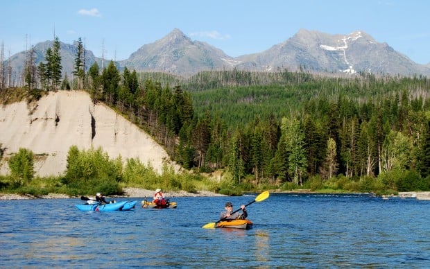
This year, since I already have an event in Glacier NP that I am participating in, I figured I might as well check out what rivers are paddle-able out there for a touring kayaker like myself. I discovered that I need not look any farther than Glacier NP itself. The North Fork of the Flathead River seems to be the best choice of paddle in the area.

49.1956°N 114.5109°W (source) 48.2802°N 114.0409°W (mouth)
I did a search on the Expo Forum and did not come up with a whole lot of detailed trip reports. This on from July 2016 had some info in it:
• http://forum.expeditionportal.com/threads/159647-Special-Agent-Cooper-Takes-Montana?highlight=north+fork+flathead+river
A google search revealed the following useful links:
• https://www.americanwhitewater.org/content/River/detail/id/1004/
• http://www.bigskyfishing.com/River-Fishing/NW-MT-Rivers/Flathead-NoFork/Flathead-NorthFork.php
• http://missoulian.com/lifestyles/recreation/north-fork-flathead-river-floaters-experience-rare-side-of-glacier/article_fe0cde74-fb20-11e3-bda6-001a4bcf887a.html
[URL="https://www.americanrivers.org/river/north-fork-flathead-river/"]https://www.americanrivers.org/river/north-fork-flathead-river/
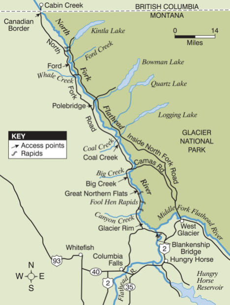
It appears the trip from the Canada Border to Blankenship (just N of the confluence with the Middle Fork) is ~58RM and is mostly class I & II with two class III’s that may require portaging in a boat like mine, or at the very least, some extensive surveillance prior to entry.
The American Whitewater link provided a useful brief trip summary from one of its members:
“Gradient from border of Canada to Blankenship bridge averages 15 feet per mile. Upper reach from Canada to Polebridge is class II but with numerous log jams and tight turns. Low water in August and after require dragging over gravel bars or portage. Polebridge to Big Creek (FS campground on right bank just after Big Creek confluence) is not considered whitewater but be alert for log jams, narrow channels, and some riffles. Big Creek to Blankenship: Some tricky hydraulics. Fool hen rapids (III upper and lower fool hen) are about 8 miles below Big Creek and 3.5 above Glacier Rim (a good access point). About one mile above Glacier Rim there is a pour off extending from the right bank to the middle of the river (or farther at some levels). This is a dangerous flipper but easy to avoid if staying alert to downstream obstacles. Stay to river left
and look it over. It can be impressive. Blankenship Bridge is 4 miles further and also good access. The stretch from Glacier Rim to Blankenship is relatively easy. The confluence of the Middle Fork and North Fork of the Flathead is just above Blankenship Bridge. Better access for vehicles is on the east side of the bridge but many stay on the west side to avoid the ferry across both forks to reach that bank. Lower water makes this quite easy. Enjoy…Greg Malone, AWA member”
The Flathead is labeled (Federally) a Wild and Scenic River in Montana (https://www.rivers.gov/wsr-act.php). Basically, this means:
“The National Wild and Scenic Rivers System was created by Congress in 1968 (Public Law 90-542; 16 U.S.C. 1271 et seq.) to preserve certain rivers with outstanding natural, cultural, and recreational values in a free-flowing condition for the enjoyment of present and future generations.”
The Flathead has all three river designation types, which are described here:
River Classification
Rivers are classified as wild, scenic, or recreational.
Wild River Areas – Those rivers or sections of rivers that are free of impoundments and generally inaccessible except by trail, with watersheds or shorelines essentially primitive and waters unpolluted. These represent vestiges of primitive America.
Scenic River Areas – Those rivers or sections of rivers that are free of impoundments, with shorelines or watersheds still largely primitive and shorelines largely undeveloped, but accessible in places by roads.
Recreational River Areas – Those rivers or sections of rivers that are readily accessible by road or railroad, that may have some development along their shorelines, and that may have undergone some impoundment or diversion in the past.

The North Fork is designated as Scenic. The Middle is Recreational and the southern end is Wild. However much I’d love to do the Wild section, logistics make it harder to plan out and execute with my boat type (shuttling, etc.).
The National Forest Service has a booklet online describing the trip in River Miles (RM). I plan to print this and laminate and ring bind it for the trip. https://www.fs.usda.gov/Internet/FSE_DOCUMENTS/stelprd3842661.pdf and this one: https://www.fs.usda.gov/Internet/FSE_DOCUMENTS/stelprd3842668.pdf
Or I could just buy it and support USFS: http://www.nationalforestmapstore.com/product-p/mt-61.htm
It appears that the US Forest Service/Flathead National Forest is the administrative agency primarily responsible for the land on the west side of the river (to the middle channel of the river) and have non-designated/dispersed camping permitted. The river falls under the Glacier View Ranger District. Here is their contact info:
Glacier View Ranger District
Hungry Horse Ranger District
Spotted Bear Ranger District (winter)
10 Hungry Horse Drive
Hungry Horse, MT 59919
(406) 387-3800
(406) 387-3889 (fax)
Primary put-in locations are: Ford Creek, Big Creek and Glacier Rim (https://www.fs.usda.gov/recarea/flathead/recreation/wateractivities/recarea/?recid=80957&actid=79).
The National Park Service permits camping only at Round Prairie. Since part of the river is under the management of the NPS, it appears I may have to get an AIS (aquatic invasive species) permit, but since my boat is self-propelled, I do not have to undergo a physical exam of my boat. I can just fill out the paperwork online (https://www.nps.gov/glac/planyourvisit/upload/AIS-permit-2016.pdf) and keep the permit on me at all times while on the river. But I will have to fill out a backcountry permit at NPS.
NPS has closed all waterways to boating due to quagga mussels spreading like wildfire as of Nov 2016. Luckily, this excludes the North and Middle Forks. https://www.nps.gov/glac/learn/news/interim-closure-issued-for-all-boating-within-glacier-national-park.htm
Here are the park rules for camping along the North Fork (https://www.nps.gov/glac/planyourvisit/river-camping.htm):
Undesignated River Camping Regulations
This list does not surprise me. It is is very similar to the one I followed for Canyonlands. My biggest source of worry/stress is the bear population out there. Which I realise most people gripe about prior to a trip out this way. But it is something I must take into consideration and make special food arrangements when I pack. This year I may invite someone to come with me (if I can find someone willing to do it) since becoming bear fodder sounds less than pleasing.
And finally, a link from the USGS monitoring the flow rate of the North Fork: https://waterdata.usgs.gov/mt/nwis/uv?site_no=12355500
So if anyone has any experience paddling this river, especially in early June, I would much appreciate any input you could give. Or if you wanted to join in, I'm game...as long as you're not a giant float boat with a ****-ton of alcohol and plan to be belligerent.
This year, since I already have an event in Glacier NP that I am participating in, I figured I might as well check out what rivers are paddle-able out there for a touring kayaker like myself. I discovered that I need not look any farther than Glacier NP itself. The North Fork of the Flathead River seems to be the best choice of paddle in the area.
49.1956°N 114.5109°W (source) 48.2802°N 114.0409°W (mouth)
I did a search on the Expo Forum and did not come up with a whole lot of detailed trip reports. This on from July 2016 had some info in it:
• http://forum.expeditionportal.com/threads/159647-Special-Agent-Cooper-Takes-Montana?highlight=north+fork+flathead+river
A google search revealed the following useful links:
• https://www.americanwhitewater.org/content/River/detail/id/1004/
• http://www.bigskyfishing.com/River-Fishing/NW-MT-Rivers/Flathead-NoFork/Flathead-NorthFork.php
• http://missoulian.com/lifestyles/recreation/north-fork-flathead-river-floaters-experience-rare-side-of-glacier/article_fe0cde74-fb20-11e3-bda6-001a4bcf887a.html
[URL="https://www.americanrivers.org/river/north-fork-flathead-river/"]https://www.americanrivers.org/river/north-fork-flathead-river/
It appears the trip from the Canada Border to Blankenship (just N of the confluence with the Middle Fork) is ~58RM and is mostly class I & II with two class III’s that may require portaging in a boat like mine, or at the very least, some extensive surveillance prior to entry.
The American Whitewater link provided a useful brief trip summary from one of its members:
“Gradient from border of Canada to Blankenship bridge averages 15 feet per mile. Upper reach from Canada to Polebridge is class II but with numerous log jams and tight turns. Low water in August and after require dragging over gravel bars or portage. Polebridge to Big Creek (FS campground on right bank just after Big Creek confluence) is not considered whitewater but be alert for log jams, narrow channels, and some riffles. Big Creek to Blankenship: Some tricky hydraulics. Fool hen rapids (III upper and lower fool hen) are about 8 miles below Big Creek and 3.5 above Glacier Rim (a good access point). About one mile above Glacier Rim there is a pour off extending from the right bank to the middle of the river (or farther at some levels). This is a dangerous flipper but easy to avoid if staying alert to downstream obstacles. Stay to river left
and look it over. It can be impressive. Blankenship Bridge is 4 miles further and also good access. The stretch from Glacier Rim to Blankenship is relatively easy. The confluence of the Middle Fork and North Fork of the Flathead is just above Blankenship Bridge. Better access for vehicles is on the east side of the bridge but many stay on the west side to avoid the ferry across both forks to reach that bank. Lower water makes this quite easy. Enjoy…Greg Malone, AWA member”
The Flathead is labeled (Federally) a Wild and Scenic River in Montana (https://www.rivers.gov/wsr-act.php). Basically, this means:
“The National Wild and Scenic Rivers System was created by Congress in 1968 (Public Law 90-542; 16 U.S.C. 1271 et seq.) to preserve certain rivers with outstanding natural, cultural, and recreational values in a free-flowing condition for the enjoyment of present and future generations.”
The Flathead has all three river designation types, which are described here:
River Classification
Rivers are classified as wild, scenic, or recreational.
Wild River Areas – Those rivers or sections of rivers that are free of impoundments and generally inaccessible except by trail, with watersheds or shorelines essentially primitive and waters unpolluted. These represent vestiges of primitive America.
Scenic River Areas – Those rivers or sections of rivers that are free of impoundments, with shorelines or watersheds still largely primitive and shorelines largely undeveloped, but accessible in places by roads.
Recreational River Areas – Those rivers or sections of rivers that are readily accessible by road or railroad, that may have some development along their shorelines, and that may have undergone some impoundment or diversion in the past.
The North Fork is designated as Scenic. The Middle is Recreational and the southern end is Wild. However much I’d love to do the Wild section, logistics make it harder to plan out and execute with my boat type (shuttling, etc.).
The National Forest Service has a booklet online describing the trip in River Miles (RM). I plan to print this and laminate and ring bind it for the trip. https://www.fs.usda.gov/Internet/FSE_DOCUMENTS/stelprd3842661.pdf and this one: https://www.fs.usda.gov/Internet/FSE_DOCUMENTS/stelprd3842668.pdf
Or I could just buy it and support USFS: http://www.nationalforestmapstore.com/product-p/mt-61.htm
It appears that the US Forest Service/Flathead National Forest is the administrative agency primarily responsible for the land on the west side of the river (to the middle channel of the river) and have non-designated/dispersed camping permitted. The river falls under the Glacier View Ranger District. Here is their contact info:
Glacier View Ranger District
Hungry Horse Ranger District
Spotted Bear Ranger District (winter)
10 Hungry Horse Drive
Hungry Horse, MT 59919
(406) 387-3800
(406) 387-3889 (fax)
Primary put-in locations are: Ford Creek, Big Creek and Glacier Rim (https://www.fs.usda.gov/recarea/flathead/recreation/wateractivities/recarea/?recid=80957&actid=79).
The National Park Service permits camping only at Round Prairie. Since part of the river is under the management of the NPS, it appears I may have to get an AIS (aquatic invasive species) permit, but since my boat is self-propelled, I do not have to undergo a physical exam of my boat. I can just fill out the paperwork online (https://www.nps.gov/glac/planyourvisit/upload/AIS-permit-2016.pdf) and keep the permit on me at all times while on the river. But I will have to fill out a backcountry permit at NPS.
NPS has closed all waterways to boating due to quagga mussels spreading like wildfire as of Nov 2016. Luckily, this excludes the North and Middle Forks. https://www.nps.gov/glac/learn/news/interim-closure-issued-for-all-boating-within-glacier-national-park.htm
Here are the park rules for camping along the North Fork (https://www.nps.gov/glac/planyourvisit/river-camping.htm):
Undesignated River Camping Regulations
- Party size is limited to 12 People.
- Camping is limited to designated river sections; see map above.
- Camping is limited to one (1) night in any campsite. Parties must move at least one (1) mile each day before establishing a new camp.
- Campsites MUST be located on durable surfaces, gravel and sand bars below high water mark are preferred.
- Wood fires are allowed if contained in a fire pan with an air space between the fire and the ground to protect dormant insect larvae that may be present in gravel river sediment. Use of fire blankets (old USFS fire shelters) is prohibited.
- All food, cooking gear and refuse must be secured from bears at all times except mealtime. This requires either suspending these items a minimum of 10 feet (3 m) above the ground and 4 feet from any tree trunk or utilizing an Interagency Grizzly Bear Committee (IGBC) approved bear-resistant food container (BRFC) at all times, except mealtime. All cooking gear that cannot be stored in a bear resistant container MUST be cleaned and kept 100 feet (30 m) from your sleeping area.
- Distance between the sleeping area and the food prep/storage area should be a minimum of 100 feet.
- Glacier National Park river users (day and overnight use) are REQUIRED to use some type of self-contained waste disposal system (Groover, Rocket box, WAG bags, etc.).
- No pets allowed.
This list does not surprise me. It is is very similar to the one I followed for Canyonlands. My biggest source of worry/stress is the bear population out there. Which I realise most people gripe about prior to a trip out this way. But it is something I must take into consideration and make special food arrangements when I pack. This year I may invite someone to come with me (if I can find someone willing to do it) since becoming bear fodder sounds less than pleasing.
And finally, a link from the USGS monitoring the flow rate of the North Fork: https://waterdata.usgs.gov/mt/nwis/uv?site_no=12355500
So if anyone has any experience paddling this river, especially in early June, I would much appreciate any input you could give. Or if you wanted to join in, I'm game...as long as you're not a giant float boat with a ****-ton of alcohol and plan to be belligerent.