Me and the Moonlander!

Gear

Explorer, Overland Certified OC0020
Lake Hodges - February 2, 2012

GoProMoonlander-LakeHodgesPinzgauer-4896.jpg

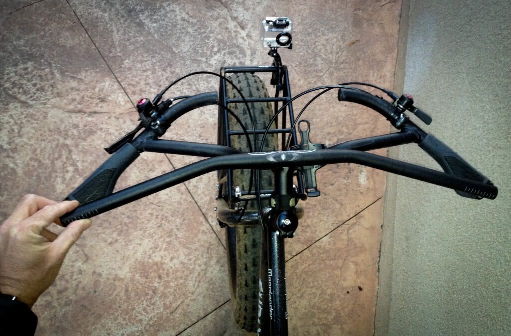
Well since this site is pretty much vehicle based. I took this shot of the Moonlander in transit to todays ride at Lake Hodges. I am starting to think that I get more questions about the Moonlander than the Pinzgauer. Who would have imagined that!

GoProMoonlander-LakeHodgesTree-4873.jpg

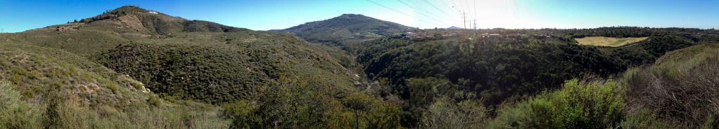
A couple of highlight photographs of the ride. I like the fact that when this tree fell they left it as an obstacle instead of just removing it.

GoProMoonlander-LakeHodgesWaterCrossingBack-4825.jpg

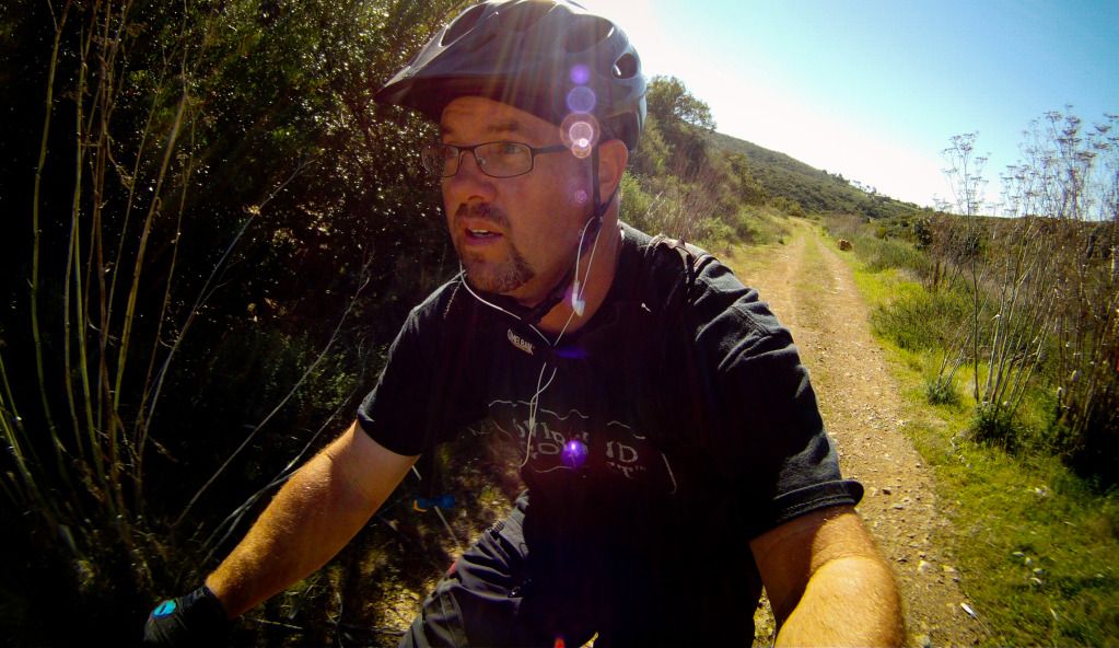
This stream crossing is always a highlight as it runs year around.

LakeHodges-Moonlander.jpg

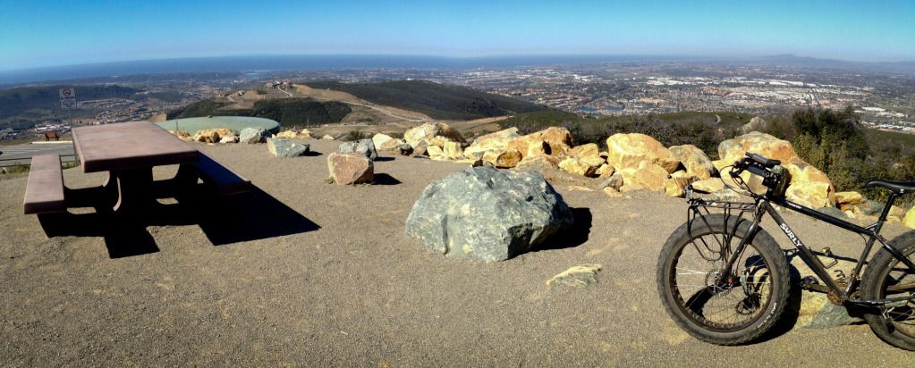
Today for a change I went Southwest from Hernandez Hideway and followed the trail down pass the dam. Some of my other rides can be seen up by the Olivenhain Reservoir. I am still looking over different ways to connect up the trails.

Distance 19.2 miles
Elevation 1718 feet
Moving Average 9.9 mph
 
Last edited:

Bullsnake

Adventurer
Justin-

GREAT pics and commentary! This is definitely motivating me to get back into biking more than I have been the last year, and has me counting down the days until my Fatback shows up at the door! Every day when I pop in here to check out what has happened overnight this thread is the first one I look for!
 

Gear

Explorer, Overland Certified OC0020
You know, your thread is motivating me to get back on the bike... and I love your ride.

That is not a bad thing! Dust it off, and pull up Google Earth around your area. I am sure there is something new around the corner?

Justin-

GREAT pics and commentary! This is definitely motivating me to get back into biking more than I have been the last year, and has me counting down the days until my Fatback shows up at the door! Every day when I pop in here to check out what has happened overnight this thread is the first one I look for!

You are going to have a great time on the Fatback. I look forward to seeing some ride reports. Glad you are enjoying the posts as well.

Epic ride time! I'll show you how to hook these trails up... :yikes:

I'm diggin' the ride reports!

:eek:
 

Gear

Explorer, Overland Certified OC0020
Down the Beach to Grandmothers house I go - February 3, 2012

GoProMoonlander-LaJollaBeach7-5028.jpg

So today I did a little jaunt down to La Jolla. 41 miles round trip on a fat bike. Here I am cranking the tunes up and heading south from the jetty at South Ponto Beach.

GoProMoonlander-LaJollaBeach5-5003.jpg

Rolling along. At times the beach is so empty that you forget that you are in the 8th largest city. I like this!!

GoProMoonlander-LaJollaBeach10-5073.jpg

This might be my new screen saver.

GoProMoonlander-LaJollaBeach11-5132.jpg

Getting close to La Jolla Shores. The terrain changes giving me a chance to get off the bike and walk. This is welcome because the saddle is getting very hard!!

GoProMoonlander-LaJollaBeach12-5142.jpg

Scripps Pier, La Jolla Shores. At the end of this beach the cliffs begin and you are forced on to the roads. Cool moment was noticing that I just rode 18.5 miles and only had an an elevation of 160 feet. There were two small rivers that I hit the bridge to bypass. One at San Elijo Lagoon and the other one just north of Torry Pines.

GoProMoonlander-LaJollaBeach16-5259.jpg

Made it. This was my Grandmothers first viewing of the Moonlander. She just shook her head. "Did that other vehicle of yours break down" referring to the Pinzgauer. "No, Grandma I used it to shuttle the bike to the beach."

GoProMoonlander-LaJollaBeach18-5300.jpg

After I fixed a few things, we sat outside for a quick chat. She wanted to know about the GoPro and Pepper(dog) wanted me to throw the ball.

GoProMoonlander-LaJollaBeach21-5404.jpg

Back on the bike for the ride home. Time to fuel up. I stopped in La Jolla at one of my favorite Taco Shops.

GoProMoonlander-LaJollaBeach13-5178.jpg

Low tide, it is now 1 pm and I am heading back up the beach into a steady headwind.

LaJollaMoonlander2.jpg


Distance 41.5 miles
Elevation 793 feet
Moving Average 10.4 mph
Moving Time 3:58 minutes
 
Last edited:

Gear

Explorer, Overland Certified OC0020
La Costa Preserve - February 4, 2012

GoProMoonlander-LaCostaPreserve-SwitchbackTrail4-0348.jpg

I washed the sand off the bike this morning and then hit the trail in the early afternoon for a quick spin. The Boy Scout Kiosk at the top of La Costa Preserve. Looking East.

GoProMoonlander-LaCostaPreserve-SwitchbackTrail-5438.jpg

The visibility today was great. You could see all the way out to Catalina Island.

GoProMoonlander-LaCostaPreserve-SwitchbackTrail2-5462.jpg

I am still trying to get comfortable on the bike(neck pain). So today I went with out the Camelbak. Instead opting for a water bottle. Unfortunately the bottle only made it a few yards and jumped ship. When I noticed this I decided to travel on in hopes of finding it on the way back.

GoProMoonlander-LaCostaPreserve-SwitchbackTrail5-0349.jpg

My verdict on the new Titec H-bars is still in limbo. I tried to buy them local but found out they had been discontinued. So I purchased them used thru Ebay. I thought they were going to come back further into the cockpit.

GoProMoonlander-TitecH-bar-0359.jpg

This shows the stock Salsa Moto Ace 17 degree bend bar on top of the Titec H-bar. One quick look shows the Salsa comes back further. Kind of a bummer.

GoProMoonlander-LaCostaPreserve-SwitchbackTrail3-5478.jpg

One other note about the Titec H-bar is the lack of control on technical terrain. The relaxed open bars make it difficult to steer at times. It also creates a reaching issue for the brakes.

LaCostaPreserve-SwitchbackTrail.jpg

Todays track in white

Distance 7.3 miles
Elevation 1306 feet
Moving Average 6.5
 
Last edited:

Gear

Explorer, Overland Certified OC0020
Rest Day/Kids Ride - February 5, 2012

GoProMoonlander-BoysElfinForest-5588.jpg

Today's ride was for the boys. A simple trek down by the river. Here is my youngest playing catch up on the fire road.

GoProMoonlander-BoysElfinForest2-5633.jpg

My two boys waiting for there friend to remove his sweatshirt.

GoProMoonlander-BoysElfinForest8-0361.jpg

Part of the gang at the end of the road.

GoProMoonlander-BoysElfinForest10-0366.jpg

My oldest kept disappearing. Saying several times that he could stay here all day.

GoProMoonlander-BoysElfinForest3-5713.jpg

On the way back we dropped down by the river for a neat little section of single track.

GoProMoonlander-BoysElfinForest4-5728.jpg

On the move again

GoProMoonlander-BoysElfinForest12-0372.jpg

The Moonlander hanging around. Seems this is a fat tire thing. They grow on trees.

GoogleEarthElfinForestKids.jpg

The Bright Red track was from today.

Distance 2.6 miles
Elevation 168 feet
Average Speed 5.8 mph
 
Last edited:

Gear

Explorer, Overland Certified OC0020
Exploring Elfin Forest - February 6, 2012

GoProMoonlander-ElfinForestNewTrail2-0373.jpg

I decided to explore some single track just east of my house. The last 6 months I have noticed some new fencing and signage. Turns out the Parks and Recreation Department has acquired the land. Once the land was purchased they removed the trailers/home that once sat on the land. The lack of dogs at this now vacant land allowed me to find a really nice new trail.

GoProMoonlander-ElfinForestNewTrail4-5895.jpg

So here I am dropping into a small canyon. I quickly find solitude along with running water.

GoProMoonlander-ElfinForestNewTrail-0375.jpg

Further down the trail I come upon this. Truly an awesome find. A small stream to the right has me wishing I brought a hammock.

GoProMoonlander-ElfinForestNewTrail3-0374.jpg

A photograph looking the other way.

ElfinForestNewTrail.jpg

For the most part I rode a giant loop exploring some new trails.

Distance 11.7 miles
Elevation 2065 feet
Moving Average 6.7 mph
 
Last edited:

Gear

Explorer, Overland Certified OC0020
Daley Ranch, Escondido California - February 7, 2012

GoProMoonlander-DailyRanch-0379.jpg

A nice overcast day in San Diego. I headed out to Daley Ranch for a quick ride before the rain.

http://www.escondido.org/Data/Sites/1/media/pdfs/DaleyRanchMap.pdf
Daley Ranch Map -

Today route - Creek Crossing, East Ridge, Sage, Caballo to parking lot. Returned up Caballo to Quail Run, Sage, Stanley Peak, Sage, Jack Creek Meadow Loop, Ranch House, East Ridge, Creek Crossing to Parking lot.

DailyRanch.jpg

Google Earth image

Distance 13.2 miles
Elevation 2099 feet
Moving Average 7.2 mph
 
Last edited:

Tadpole

New member
Moonlander = Land Rover!

I've really enjoyed this thread - cool hardware being used as designed. It's nice that there are so many trail options available. Here in the East, it seems that the park service / state closes the land to all access.

Keep posting!
 

Gear

Explorer, Overland Certified OC0020
I've really enjoyed this thread - cool hardware being used as designed. It's nice that there are so many trail options available. Here in the East, it seems that the park service / state closes the land to all access.

Keep posting!

Thanks for the positive feedback. I am definitely enjoying the Moonlander. As for the trail options, if you had asked me a month ago I would have told you a completely different story. Oh yah we have a couple of nice trails, but now with Google Earth and a different mindset I am finding all sorts of different ways to get to and from places. Stay tuned for more adventures!
 

Gear

Explorer, Overland Certified OC0020
San Elijo Hills - February 8, 2012

DoublePeakRide-HillTop-0384.jpg

Todays trek on the bike was about exploring trails that I have been viewing on Google Earth in and around San Elijo Hills. While todays ride was a success in many aspects I did not come away with any outstanding photographs or epic single track. Instead I linked up a great fire road that I had been eyeing for a while. So without further ado, my ride today. (Photo on top of Frank's Peak)

DoublePeakRide.jpg

I rode this clockwise from the bottom left. North has been spun to get it on the page. I hit the Tower, Double Peak, and then over to Franks Peak. Franks Peak is the curly cue at the top right of the page. This is were the fire road took off down the backside and ended up dumping me out onto Questhaven Road.

QuesthavenRoad.jpg

Another angle of the fire road. You can see where it T's into Questhaven Road. I then traveled South on Questhaven hopping for an access point so I could link up with the green trail(post #54) that I rode the other day. Unfortunately it looks like every access point is under lock and key.

DoublePeakRide-LakeSanMarcos-0381.jpg

On the first map as you climb up to the Tower you are treated to a nice view of the Lake San Marcos Dam. Water was just barely spilling over from yesterdays minimal rainfall.

DoublePeakRide-DoublePeak-0382.jpg

This is the top of Double Peak Park looking West/North West.

DoublePeakRide-DoublePeakTree-0383.jpg

One more of Double Peak Park looking South.

Distance 16.8 miles
Elevation 2813 feet
Moving Average 6.6 mph
 
Last edited:

Gear

Explorer, Overland Certified OC0020
Outer Loop - February 9, 2012

Moonlander-OuterLoop9-6259.jpg

On my quest to ride new trails I ventured out the door and headed South. The idea - link several trails to make an Outer Loop.

Moonlander-OuterLoop3-6058.jpg

Here I am climbing a trail that leads to a high point just south of the Old San Marcos Dump.

Moonlander-OuterLoop4-6072.jpg

A lot of climbing these days. The Moonlanders low range and great traction make it seem easy.

Moonlander-OuterLoop-0391.jpg

Once on top I skirted over to this view point overlooking a golf course. Later I will be exploring the canyon below.

Moonlander-OuterLoop6-6127.jpg

Once down in the canyon I cross the creek.

Moonlander-OuterLoop7-6222.jpg

My studies of the map show a trail in this canyon. Sure enough I find it and venture down the canyon as far as I can go.

Moonlander-OuterLoop11-6186.jpg

The Escondido Creek was flowing well. I stopped to have a snack.

Moonlander-OuterLoop10-6274.jpg

Then it was more double track around the mountain towards Elfin Forest Road. From there I simple retracted my route up the Old Questhaven Road and back into San Elijo Hills.

Moonlander-OuterLoop.jpg


Distance 15.1 miles
Elevation 2335 feet
Moving Average 6.6 mph
 
Last edited:

TangoBlue

American Adventurist
Still have neck pain? Perhaps a shorter more upright stem? A few degrees and centimeters can make a big difference in your comfort.
 

Forum statistics

Threads
189,834
Messages
2,921,476
Members
232,931
Latest member
Northandfree
Top