Don't Throw Your Life Away - Battling Marine Debris from Alaska to Panama

Voyager3

Active member
So good. Preciate you and your journey. Also be interested in your timeline, I'm currently in Seattle but am heading out East in the fall. Maybe I can help you out with the bike if needed!

Thanks! So roughly, Alaska a couple more weeks, enter back into Canada early September aiming for the Great Lakes as far north as I can stay. I will be dipping into Ohio of all places, mostly to see the XB-70 Valkyrie at the National Museum of the United States Air Force. Also, it turns out a couple people I went to elementary school with live there now, and one is heavily into ocean conservation...isn't that lucky. If it's possible, I might hit the other coast of Canada before going back down into the States properly and my only time commitment really is working Overland Expo again at East, November 9-11. Get your tickets soon. I'll likely be there the Tuesday before to the Tuesday after setting up and tearing down.

One of the best trip reports ever. Really enjoying your pictures, your writing, and your sense of humor.

Stay safe on the rest of your adventure. And give Jenson a pat on the head for me!

I appreciate that, I'm glad it's worth reading! I will give Jenson an extra one for you. :)


by far one of the best trip reports I've seen and what makes it better is there wasn't a one year build-up and thousands and thousands of dollars put into every bolt on and "overlanding" essential crammed into and on top of your rig . This journey is a fantastic example of you dont need a "built" rig to explore , you just need to get out the door .

Thank you so much! Here's the peculiar thing, well one peculiar thing....I also saw a salmon today that was still breathing with its eyes pecked out by a bird...that was peculiar. But with trip planning, I knew I was leaving on a trip of this magnitude as early as last summer. You'd think I would be more prepared. Perfect preparation and all that. Maybe that's why 7P hasn't offered me a job.

Some of my favorite "overlanding" stories from others are haphazard and unorganized.

Most of my other trips have been that way, too. The real reason I rode the 916 from Denver to my friend's bachelor party in Vegas in a day was I realized a few days before the date that I hadn't gotten around to booking a plane ticket. So I borrowed a backpack from another friend for my nice clothes, plus my tank bag and hit the road for the desert. You can plan something till you're blue in the face, but the bolt that holds your shifter on is still going to back out and you'll have to use things you found on the ground around a gas station to fix it.

Agrred. And making the world a better place as you go. Bravo!

:) Thanks kindly, I'm trying anyway.
 

Voyager3

Active member
Oh Alaska, you just keep getting better and better. I woke up here. That's not bad is it?

20180815_073729.jpg

I hope you like history, because I've been learning a lot.

But first, when I arrive at a port town, I go find a harbor. I went down to the water front and not only did I find many vessels I had never seen before, but I also saw this one, which I had seen before. On the television. Deadliest Catch fans will recognize it/

20180815_143150_1534372324650.jpg

20180815_153021.jpg

So this day, Valdez is fairly well socked in. None of the what I can assume are lovely mountains are really visible, though they're giving tantalizing little clues as to their grandeur. Evident also are the numerous waterfalls trickling down off of the peaks. After a walk down every single dock in the harbor it starts to rain for real. We are already off to a pretty late start after the previous travel day and meandering around the docks, so by the time we get around to the Valdez Museum, it's only open another hour. But we can get a lot done in an hour if I must.

Before we go any further, I chose Valdez as a sort of “goal” destination for the northern part of this trip because this is an environmental program afterall, and I've just recently turned 29, and the Exxon Valdez oil spill was 29 years ago. Rather than show you trash pictures, allow me to learn you up on some oil spill knowledge, because that's often times what the name Valdez conjures up. Valdez as some of you may know is the bottom of the Trans-Alaska Pipeline. It received the first barrel of oil through the pipeline on July, 28 1977. (It did as you can see from the snippet above get a barrel just before that by dog sled). It is the country's northernmost ice-free port, and therefor very important to this end. This strategic location was also very important for the town's early days. More on that later.

20180815_161502.jpg

20180815_161446.jpg

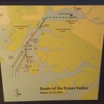
March 23, 1989. The tanker ship Exxon Valdez sails from the Marine Terminal towards Prince William Sound with 53 million gallons of crude oil. She is sailed out by license coastal pilot, Ed Murphy with Captain Joseph Hazelwood present on the bridge. Past Rocky Point, Murphy leaves, and Hazelwood is in control. Ice had been reported in the sound, and Hazelwood radios the Coast Guard that he may divert into the inbound traffic lane if it's clear of traffic to avoid the ice. He then does so, intending to skirt around towards Bligh reef before cutting back to the lanes.

Here's where he went wrong. He then, before this maneuver was finished, handed control of the ship over to Third Mate Gregory Cousins with instructions to return to the southbound lane after passing the Busby Island Light. Then he leaves the bridge. The report is that he was also drunk while below decks. Cousins was not certified to pilot the ship north of Bligh Reef. The lookout twice warned the bridge the course was incorrect. At midnight, the ship makes one last turn to correct, but at 12:04 on Good Friday the ship strikes the reef. The impact punctured 8 of the ship's 11 tanks, spilling 5.8 million gallons of oil in just the first three and a bit hours.

I apologize if my phone pics from inside the museum are a little fuzzy, low light and all.
20180815_160707.jpg
gunk.jpg

There were a couple reasons it got as bad as it did. The first was just the sheer quantity that escaped the ship so quickly. Exxon maintains that 10.8 million gallons were spilled, some estimates put that number closer to 38. Whatever the real number was, the cleanup was poor. It's challenging in any spill to reach 100% containment, but in the beginning of this spill the response times were dismal. A combination of lack of resources and a poor inter agency understanding of jurisdictions meant that many hours went by before anything was on the scene to do anything about it, and even then, the process was inefficient. By the time of the 27th, the window of opportunity they had to contain it was gone and a 70mph storm blew the oil out of the Sound and into the Gulf of Alaska. Now it was a scramble to catch up. Ultimately because of all this, the oil ended up traveling 490 miles from where the ship ran aground and affected some 1,300 miles of coastline.

20180815_160930.jpg

The impact on local wildlife, hatcheries, and sensitive areas was profound and many species are still recovering, some have not. Estimated casualties include 250 to 500 thousand seabirds, 2,800 to 4,000 sea otters, 300 harbor seals, 250 bald eagles, up to 22 killer whales. Fish deaths are harder to manage, but possibly billions of herring and pink salmon eggs. How many species rely upon things like herring as a food source? Up to 50% of the 1,600 birds brought in for treatment died while getting it, and high mortality was suspected of those released back into the wild as well.

Did any good come of this after? Well, since then because of strict policies now regarding shipping in and out of the area, over 11,000 tanker escorts have passed through without incident, and Prince William Sound is now one of the most protected environments in the world, absorbing nearly 1/3 of the U.S. Spending for oil spill prevention and recovery. There's also better training, technology and planning in place for a possible spill.

Legal compensation is a tricky subject because while $5 Billion had been awarded to the local fishermen, natives, and landowners who filed a class action law suit, it didn't really work out that way. Between 1994 and 2008, the suit went though many appeals and the Supreme Court eventually ordered Exxon to pay just $507.5 million. However in this time, nearly 20 years since the spill, more than 3,000 of the original claimants had passed away before that ruling came.

Environmentally, on the surface at least, it seems to have mostly recovered. This is harder to judge because perhaps only 10% of the spilled oil was ever recovered. Much of it sank because it was cold and will be slow to disperse, and there were reports even as recently as a few years ago that there was still oil just under the rocks on some of the beaches. As I said before, some species to this day are still in the process of recovering and some never did. It's also a good time to point out that as bad as the spill was in terms of contamination from a one time event, it's still dwarfed in general by other slower means like natural seepage and leaked from automobiles and boats for sheer volume over time as you can see here.

20180815_161319.jpg

Which is why when the internet said “The 4.0L just leaks, they all do that.” I said, but they don't have to, and did the bottom gaskets anyway. And it doesn't.....power steering fluid yes, but very slowly. It's a work in progress, nobody's perfect.
 

Voyager3

Active member
While Valdez itself seems to have missed out on being directly impacted by the spill, if we wind the clock back to another Good Friday, this time March 27, 1964, we find the town at the epicenter, or rather just 55 miles east of the epicenter of the largest earthquake recorded in the northern hemisphere, and the second largest ever. Along with other towns like Seward, Anchorage, Kodiak and more, Valdez was rocked by nearly 5 minutes of a Magnitude 9.2 quake. Witnesses recall seeing rolling waves in the earth 3 tot 4 feet high, and trees swaying such that their branches struck the ground with each oscillation. The quake caused water to slosh in African wells and swimming pools as far away as Australia.

20180815_161930.jpg

Besides the fissures and geysers in town and the vertical and horizontal movement of the earth itself, the major damage and loss of life occurred because of the liquefaction of the coastline and the local tsunami that resulted. A section of the delta the town was built on roughly 4000 feet long by 600 feet and consisted of 98,000,000 cubic yards of material fell into the sea. In all, 32 people lost their lives there, most of those on the docks which simply disappeared.

The S.S. Chena was in port at the time, and 28 adults and children had been down on the docks to watch and catch fruits and candies thrown down from the crew. Here is one account from a crew member. “It all started with a light shaking. Then it shook harder and harder. I looked out on the pier. Guys, maybe 30 or more were running out of the warehouse. I thought there might have been an explosion in the warehouse. About two-thirds of them got into the dirt part of the causeway, trying to get up to town. The ship was going up in the air – Boom – Boom – BOOM! Like a rough elevator. I could look over the side and there was no water. We were way up in the air. The men on shore disappeared. There was one guy left in the hole (fissure) scrambling to get out. You should have seen the look on his face. People in town said the ship went so high they could see underneath it. All this happened in slow motion. People, buildings, everything went down the hole. The hole was full of pilings and rubble. A wave came in and took everything else.”

20180816_131702.jpg

During its tangle with the docks, the 400 foot frieghter listed over 50 degrees on the 30 foot wave, and people on shore recall being able to see the propeller out of the water, dripping. The Chena was spared being smashed completely on what was left of the shore and it was able to be diverted away with a second wave getting underneath it.

In addition to the local tsunamis across Alaska running up fjords, with a recorded maximum of 220 vertical feet up the narrow Shoup Bay, the main tectonic ripped across the Pacific. This wave, among other things, managed to kill 4 children in my most recent residence of Newport, Oregon when it hit at 11 feet in height.

20180816_133912.jpg

20180816_133939.jpg

Valdez was damaged badly enough to warrant the moving what was left of it to a new site a couple years later. Some 54 structures were saved and moved to the new site with the rest being burned to the ground. However, we can see that the old townsite of Valdez was built in a pretty precarious place anyway. It was alright to set up the initial tents and find the quickest way inland to where the gold was beckoning the prospectors, but the town flooded annually as the Valdez Glacial Stream wiped out parts of it, prompting the residents to keep building dykes to keep the floodwaters at bay. The site to the west that would become the new Valdez is seen here before the earthquake because earlier when Valdez nearly had a railroad, that's where the terminal and supporting infrastructure was going to be developed. More on how Valdez never got a railroad soon.

20180816_131300.jpg

I went down to the old townsite which these days is just the ghosts of streets and the occasional building foundation. It's been reclaimed by nature. However, it is a peaceful spot, and the smell of the ocean here was as intoxicating as it's ever been. So bracing and delightfully pervasive that I wished I could have bottled it.

20180816_102246.jpg

Here's a short break before more history. Other interesting sights in Valdez like this rabbit.

20180816_114620.jpg

This salmon, still breathing but not seeing.

20180816_110320.jpg

And my other campsite.

20180816_091343.jpg
 

Voyager3

Active member
This closeup of a 1907 Ahrens Steam fire engine

20180816_123154.jpg

Damn Vegans? Virgins? Or Tim's suggestion virgin bears?

20180816_165803.jpg

This funny note at the end of the museum feedback section.

20180815_162731.jpg

Ok, so. The railroad. Before we get to the railroad, we have to discuss why the railroad was so desirable to the fledgling Valdez. As an ice free port, it was a year round arrival point for prospectors arriving to make their way inland to the interior and the Klondike in Canada. One of the reasons Seattle boomed back around the turn of the last century was to cater to prospectors heading to Valdez on the sea route to Alaska. Folks going overland would be going through Canada. Valdez spent many years as a small site of tents and small structures where prospectors passed through to hopefully strike it rich mining for gold. The town really started to get going when some entrepreneur types started setting up to mine the prospectors.

The town was no good to anyone unless there was a safe and reliable way through to the interior, but it was really difficult to leave Valdez. Eventually a pack trail through Thompson Pass was built in 1898 by the U.S. Army to provide an all American route to the Klondike. After the gold rush was maintained for access to Fort Egbert in Eagle and a telegraph line was built along it. Its importance led it to grow from a pack trail to a wagon trail and then an auto route which saved the town strategically. This, the Richardson Highway became the first major road in Alaska, from Valdez to Fairbanks.

20180815_163042.jpg

20180815_162510.jpg

20180815_162514.jpg

Besides the inherent costs, what kept a railroad out of Valdez from becoming a reality was partly the challenge of even cutting a railway through Keystone Canyon that led inland, and partly that as many as a dozen railroads were proposed with Valdez as the terminus and perhaps nine different companies were competing for the route.

The problem for Valdez came to a dramatic end when the Copper River &Northwestern Railway was cutting through the canyon. They were backed by the Guggenheim and Morgan families. Their competitors, the Alaska Home Railway maintained that the Guggenheims were holding a right of way they did not intend to use, as they were also surveying other routes from Katalia and Cordova to get the CR&NW to the Kennecott copper mine. The Guggenheims posted men to barricade the canyon and when the Home Railway men came with their tools, a gunfight left one man dead and several injured. Valdez was outraged and placed most of the blame on the Guggenheims who then left, and eventually chose Cordova for the terminus for the fantastically profitable Kennecott mine. The Alaskan Home Railway pulled out as well, leaving many of his supporters in debt, and Valdez never got its railroad.

Now, the CR&NW has a great history and I was going to run into it again quite by accident.

Oh wait, before we leave Valdez, one picture of food. Pulled pork at The Potato. Now, it turns out the brother of the guy I ordered from runs the local water taxi, and after hearing about the trash aspect of the trip connected me with him on the off chance that there was a trip going out I could hop on to get to a beach. But they didn't have anything running the day after I asked, and then the following day was the Potato man's birthday so everyone was otherwise engaged. I did pick up some unexciting bottles and chip bags on a walk out on a peninsula near the small boat docks, but not much else to report. So Valdez stop complete, we backtrack and go find the railroad.

20180815_192546.jpg

On the way back out, we meander out to a spot we visited when we came in, but it was cloudy. We'll give it one more shot.

20180817_133014.jpg

There we go, much better.

20180817_133318.jpg
 

Voyager3

Active member
Here he is, hunting pika

20180817_133646.jpg

And happy about literally everything.

20180817_133958(2).jpg

20180817_134258.jpg

Even the horse with no name is feeling good. I like this one because I can imagine it pretending to be a dragon, steamy breath over the craggy peaks and all.

20180817_134401.jpg

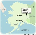
After leaving Valdez I was hoping the weather would clear more because I was headed towards Wrangell St. Elias National Park and Preserve. If you've never heard of it, it can't be because it's small. It is in fact the size of Yellowstone and Yosemite....and the entire country of Switzerland combined. 13.2 million acres. It's big. The mountain ranges within the park hold roughly 60% of the state's glacial ice, more than 1,700 square miles of ice. You know what, the whole state is massive, because if you look at a map of where the park is, it looks sort of normal sized.....

map.jpg

But then I would tell you that just Alaska's wetlands cover 43% of the state which means that just the soggy parts of Alaska cover more territory than Texas. It's really big. So, into the park. First you have to pass through Chitina, which way back in the olden days of the mining booms in the 20s, well before statehood was apparently bigger than Anchorage or Fairbanks and could have been the capital. Oh have times have changed. I'm currently writing this from Anchorage and can confirm, it's much bigger now.

20180819_141745.jpg

The reason Chitina was once so well populated was because that railroad that Valdez never got went right through here carrying lucrative, high quality copper ore from Kennecott to Cordova. When you arrive in town, I suggest going to the ranger station and at least getting the audio tour CD. I found it very interesting and nice to play instead of music which didn't fit the landscape, or just listening to the Jeep rattling.

Before heading east on the McCarthy Road, I went down the river to where the locals were cleaning their catch of salmon, an interesting site as they all gathered around the truck to clean the meat they keep and chucking the carcasses back into the river, which is what would have happened anyway after they spawned.

20180817_160237.jpg

This image was reminding me of my talks on the mind and water. Sometimes it may feel like you have clarity, and it's a struggle to maintain that against the onslaught of murky public opinion. Something like that. Then a big salmon carcass floats by. Maybe you can think of it as a bad thought that comes and goes. Or maybe you think this is all psychobabble and pay no attention to the words and just think it's an interesting picture of a clear mountain stream with a dead fish in it flowing into a silty glacial river.

20180817_160535.jpg
 

Andy G

Adventurer
Forgot to add...I lived in Alaska for 15 years, and call it my true home, even though I was born and raised in Northern Michigan. I always love seeing Alaska through a visitors eyes - and you do a great job of capturing all the amazing things that Alaska has to offer!
 

Voyager3

Active member
Great report. I enjoyed the quick history on Valdez.

Thank you! I'm glad, Valdez was great.

Forgot to add...I lived in Alaska for 15 years, and call it my true home, even though I was born and raised in Northern Michigan. I always love seeing Alaska through a visitors eyes - and you do a great job of capturing all the amazing things that Alaska has to offer!

That's awesome, I appreciate that. I want to keep this an interesting read, Alaska is sure making it fun!

Still loving the report. Great job.

Appreciate it! I will today, make it down to a beach and hopefully find a way to be useful instead of just eating all of Alaska's food. I still have to post to Kennecott and now I'm all the way to Whittier, still catching up this morning while it's foggy, then to the beach!
 

Voyager3

Active member
Heading into Wrangell-St. Elias I let my true overlanding skills shine. The road starts out dirt through this one lane section.

20180819_140016.jpg

It used to be a tunnel and then later had the top blown off to make this. I decide to air down a bit for comfort, as you do. Not an eighth of a mile later, it's paved again. Well surely, it's just at each end of this lovely bridge I think, so I'll be in good shape for the rest of the road. The McCarthy road was all the Copper River & Northwestern railway. When it was turned into an auto route after the mine shut down...oops (spoiler alert) most of the rails were removed to be reclaimed for scrap only to be claimed later as casualties of the 1964 Good Friday earthquake. Anyway, the road had a gravel bed laid right on top of the ties, and some of them pop up every now and then along the way to remind you you're on the old route to the mine.

20180817_165501.jpg

20180819_133930.jpg

The old bridge in this spot over the Copper River when the McCarthy Road was still the CR&NW used to get badly damaged in the spring breakup as the river ice smashed the timbers of the bridge. Eventually, the engineers removed the rails from the bridge each spring as the river thawed, allowed the breakup to take what it wanted as it pushed down river, and then they rebuilt what needed to be rebuilt every year.

20180819_135011.jpg

20180819_134224.jpg

The road did turn into dirt again after the bridge for a mile or so it seemed. Then pavement. But I'm optimistic. It stays pavement. Maybe I'm just stubborn. So I stay aired down longer and longer knowing that if I stop now to admit my mistake and air back up for this normal road, it would soon turn back to dirt and I would feel even sillier. About 20 miles in I cave and return to street pressure.

Yep, in minutes it's dirt again. And this time for good. So do I do an overlanding thing again? I have a chance now to be like everyone else on this road and just drive normally with normal tire pressures. But then what would I tell my internet audience? That I used my superior skills and knowledge to air down only for the 20 paved miles of a 60 mile otherwise dirt and gravel road? Oh how they would laugh.

So I caved again. I was determined to feel like I alone, out of everyone traveling this stupid road, was doing it right and adjusted my tire pressures. This is more a peer pressure issue than tire pressure.

The Copper River & Northwestern project was called by critics the Can't Run & Never Will due to the incredibly unlikely feat it seemed to be to run a line from Cordova to Kennecott and keep it maintained. Started in 1906 and completed in 1911, it spanned 196 miles with 273 bridges making up over 30 of those miles.

20180819_115900.jpg

This metal behemoth is called the Kuskulana Bridge. It was built from both ends, 160 feet out on each side, meeting in the middle where they lowered the final 225 foot section into place. This meant that first the equipment and materials had to be strung over the gorge by a 1.5 inch thick cable. Fifty tons of steel rails were laid on the outer anchor spans to drop the final section in. Construction of the whole bridge took just 2 months. Lit by acetylene lamps in the dark because it'swinter, between -30 and -54 Fahrenheit.

20180819_115930.jpg

20180819_124710.jpg

20180819_124823.jpg
 

Voyager3

Active member
There is a cool little walk in campsite on the west end of it underneath, and there is a walkway in the trusses of the bridge itself. This was mentioned on the audio tour, but all entrances to it have been removed. So, someone doesn't want us to go up there. However, if you park your truck under it and climb on, it's a fun trip provided you're not afraid of heights. Now I've been skydiving, paragliding, and aerobatic flying. I've rock climbed plenty and climbed mountains as high as 19,340 feet. But I have to say, this was getting to me. Maybe it was the size of the gap under the railing, maybe it was the fact that everything you were standing on and next to it was just gaps between girders. Exhilarating yes, and a great perspective on the difficulty of building this bridge over 100 years ago regardless of how terrible the weather was. Another fun fact, after this was converted into an auto bridge it stayed the same narrow train width but for years they never bothered putting guard rails on it. Imagine driving this with nothing between you and the icy river 238 feet below.

20180819_125117.jpg

20180819_130548.jpg

20180819_130551.jpg


20180819_130837.jpg

20180819_130935.jpg

20180817_175154.jpg

For the evening I camped under this lovely wooden trestle, one of my favorite remnants of the railroad. This, the Gilahina Trestle was the longest at 890 feet and stood 90 feet off the ground. It consisted of half a million board feet of lumber and was assembled in just 8 days. No small feat when the thermometer dipped at one point to a staggering -67 degrees F. It's still mostly standing today, and to have a campsite behind it was fun.

20180817_182650.jpg

20180817_190347.jpg

20180817_190411.jpg

What do you suppose made this?

20180817_183020.jpg
 

Voyager3

Active member
Since I'm not only an off-roading expert, but also a camping expert, let me show you something. Let's say you broke your spoon/fork combo on one of those dehydrated backpacker breakfasts days ago. You think if will never happen to you, but it could. What are you to do when it comes time to eat soup?

20180817_183744.jpg

Protip: take that bit of spoon you have left and clothespin it to a stick. Bam. Problem solved. And it's even easier to put up when you need to grab something else. Although I burned that soup in the short time it took to assemble this new spoon. If that's possible. I burned soup.

20180817_184433.jpg

If tips like this are of interest to you, be on the look out for the new book by my alter ego Dirt Wilson due out later this year. Airing Down for Asphalt.

20180817_184942.jpg

The next morning we again headed towards McCarthy and had a bit of a walk early on at the Crystalline Hills area.

20180818_111147.jpg

20180818_101449.jpg

20180818_102030.jpg

To get to the mine at Kennecott, you have to park and walk over a footbridge and either walk or shuttle about a mile to McCarthy, then walk or shuttle I think 4 more to Kennecott. Between the last normal auto bridge washing out, and this pedestrian affair, travelers here had to cable over in a little two seat gondola arrangement over this and another river to get across to McCarthy. The cables are still visible. I walked to McCarthy, but didn't stay long as I was planning on paying the $5 to shuttle up the hill to Kennecott, and then walk back down the whole way later.

20180818_133030.jpg

20180818_133117.jpg

20180818_135840.jpg
 

Voyager3

Active member
How are these new enormous pictures working out? Keep them or go back to links hosted from online sources?

The railroad served the Kennecott copper mine for 27 years before it shut down in 1938 when copper prices dropped too much and the copper was finally exhausted from the mine. But during that time, it was outrageously successful, making it worth the expense and effort to get the line out there in the first place. The first rail car load out when the line was completed carried $250,000 worth of high grade ore on the order of 85% copper, and the mine would eventually go on to pull some $200 million out of those hills, profiting $100 million. In old timey dollars. That makes this mine more like a $1.6 billion dollar winner today.

20180818_143348.jpg

20180818_143623.jpg

20180818_143843.jpg

20180818_144058.jpg

20180818_144304.jpg

20180818_144810.jpg

20180818_151435.jpg

20180818_152146.jpg

20180818_153758.jpg

20180818_153839.jpg
 

Voyager3

Active member
When the craigslist ad says "Have all the parts, just needs reassembly"

20180818_144557.jpg

20180818_154129.jpg

20180818_154610.jpg

This was a refrigerator. Yep, even out here, and its door

20180818_154754.jpg

20180818_154817.jpg

The mine did go through a period of decay, it's been a long time since 1938 when it shut down mining operations, and it's a bit of a wonder sometimes that things like this survive, but efforts have been made over the last couple decades to restore it, and it's a great exhibit. It was listed on the National Register of Historic Places in 1978, be came a National Historic Landmark since 1986 and many of the significant buildings were acquired by the National Parks Service in 1998.

You know what else it has? A food truck.

20180818_155819.jpg

20180818_160454.jpg

Because when you're going to walk back the 6 or so miles back to your truck and you already saved the $5, put it towards some curry steak. But, as good as the truck was, I suggest not just asking them to kick it up a notch like I did, but maybe a couple more notches. As I go north, people's understanding of spicy has gotten warped.

I feel it's well worth the side trip out if you're in southern Alaska. The McCarthy road, Wrangell-St. Elias, the towns and mine at McCarthy and Kennecott. Really a cool place to be. Oh, and that's all glacier down there, just covered in moraine rocks a couple feet thick across most of it.

20180818_143230.jpg

Rat-rodding when it wasn't cool, but necessary. Ran up until the '90s

20180818_180223.jpg

20180818_180313.jpg
 

Voyager3

Active member
It was time to point this circus west again, enjoying the park on my way out. I even earned a couple beers helping a two ladies change a tire, and get ready for the full circle, their spare was at a meager 25psi, so I busted out my compressor and was the hero overlander again. "You have a compressor in your car?" Yes, ma'am, I do. It's from stories like this the legend of Dirt Wilson will grow.

20180818_180927.jpg

20180818_200251.jpg

20180818_203212.jpg

Sometimes I'm happy to have a small truck, this bank was falling down periodically, but I had plenty of buffer zone.

20180819_101400.jpg

The Gilahina Trestle again.

20180819_105033.jpg

And some of those Alaskan wetlands.

20180819_113512.jpg

On the way out on the highway back to Glenallen, I stopped at an unremarkable rest stop with a pretty view on the side of the road to rest up before heading to Anchorage.

20180819_155456.jpg
 

Forum statistics

Threads
188,039
Messages
2,901,516
Members
229,352
Latest member
Baartmanusa
Top