Garmin Base Camp- Create Route- follow trail or road?

mvbeggs

Adventurer
I am planning a trip from Silverton, Co to Moab, UT. I've been studying the Delorme Gazeteer and have found the combination of roads and trails to get me from Silverton to Moab. I'd like to create a route in Garmin Base Camp to make the navigation on the trail easier.

In Garmin's Base Camp I understand how to make a route, or track, by adding individual points to create a route. What I'd like to do, is click on a trail, forest road, etc. and have the software add the points along the road. Anyone know how to do this in Base Camp?

Here's an example- first leg- leaving out of Silverton, Co and taking Ophir Pass, also known as CR 8, over to Highway 145. Ophir Pass is well defined but makes quite a few twists and turns on it's way over to 145. I really don't want to have to add a point at each turn to create the route. Anyone know how to make Garmin's Base Camp create a route using an existing road or trail?

Here's the route (highlighted) I'd like Base Camp to create for me:
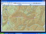
Ophir Pass.jpg

Any ideas?....Thanks
 

crismateski

American Adventurist
I dont know that you can do it in base camp, but I downloaded Garmin road trip (free) and it has a route tool that will do that.
 

mrshish

Observer
I am planning to do the same thing but haven't bought the Garmin Topo maps yet so can't help you other than making sure you know that to make a route you need to be using the Garmin Topo 24k maps. They have the routing information built in. If you are using the downloaded maps it won't work.
 

crismateski

American Adventurist
I am planning to do the same thing but haven't bought the Garmin Topo maps yet so can't help you other than making sure you know that to make a route you need to be using the Garmin Topo 24k maps. They have the routing information built in. If you are using the downloaded maps it won't work.

I used the road trip method with both my garmin car navigation unit, and with my 62 with the 100k maps. Good luck
 

Token

Explorer
Can't help you with the map much.. If you're trying to do it all offroad, that may be a task..

Last August my daughter and I made a trip through South West CO and on up into Moab..

Route was basically from Creede, CO across Stoney Pass to Silverton
Up to Ouray and across Imogene Pass in to Telluride.
Took Last Dollar Road over to Hwy 62 (Long way outta the way to be on the dirt and see the sights), then back to Hwy 145
Take the pavement up to Gateway, CO.
Out of Gateway to the west there's a road called John Brown Road, this is the first leg of dirt getting across the CO/UT line and on into Moab.
Roads on the CO side are well marked with signs pointing to Moab at every crossroad.
Once you cross into UT, you better have good maps and direction skills. I had to make up the route from 3 different digital map sets from various programs. None showed a complete route, but each one showed enough to put together a route. As long as you keep heading west you'll eventually run across Hwy 191 or 128 along the Colorado River.

When we crossed it had just rained and the moment we crossed into UT where the trail wasn't as maintained we hit several miles of sloppy 3 inch deep mud.. We were the second set of tracks since the rain the day before. If it hadn't been for the rain it would have been about 6 inches of bull dust.. Just go slow and stay outta the ditch.

We were taking the trip alone, taking a route that might or might not all be there and I was having some bad noises coming out of the front differential.. The moment we pulled off pavement at Gateway, I texted a friend back home, told him where we were, where we were headed and asked that if he hadn't heard from us in Moab in 24 hours to make a phone call. I was only expecting a 4 or 5 hour trip across, but figured if there was something that happened I could take care of it and still make Moab in 24 hours.. If not, I'd prolly need assistance of some sort.. Had plenty of water and food to be enough for several days if needed.. Better safe than sorry though..

Ended up making a right turn off of Gateway Road onto LaSal Mountain Loop Road in Grand County, UT and ended up north east of Moab on Hwy 128 rather than ending up on Sand Flat Road going straight into downtown Moab...

Was a great trip though.. Would love to do it again one of these days when I wasn't stressed out over noises coming out of the front end of the rig..
 

mvbeggs

Adventurer
Great info

Thanks for the information. The route I have planned is to take Ophir pass from Silverton, to 145, and work my way south of the needles district, eventually tieing into Lockhart basin and into Moab from there. Should be fun. I just wasn't looking forward to putting all those points in by hand.

Maybe the problem is the topo I'm using. I installed the Funtreks electroninc data that has background topo info included. May try turning that off, reverting back to the 100k Garmin maps, and see if that makes a difference. I'll report back if I find a way to "auto route" an existing trail or road.

Thanks again.
 

UK4X4

Expedition Leader
In mapsource( easily added to your base camp- just go to garmin and download the latest update for mapsource and you'll have both programs)

If i'm planning a trip and want to force the program to a particular route

I just add waypoints along the intended route, go to create route put in the way points in the correct order and press calculate

It then "usually" displays the route I want which is downloaded to my garmin

If it misscalculates the route I want I add in a few more way points
 

mvbeggs

Adventurer
In mapsource( easily added to your base camp- just go to garmin and download the latest update for mapsource and you'll have both programs)

If i'm planning a trip and want to force the program to a particular route

I just add waypoints along the intended route, go to create route put in the way points in the correct order and press calculate....

What is the difference between Base Camp and Mapsource? Will Mapsource export the route into a format that is importable (is that really a word?) into my Oregon 400 and Nuvi 50?
 

UK4X4

Expedition Leader
Just took a look at Base camp it does not seem to have the needed buttons

Down load and install the latest Mapsource update,

http://www8.garmin.com/support/download_details.jsp?id=209

As you already have basecamp it should install and add the program to your garmin folder

In mapsource there's a download /upload button

which when you connect your GPS you should be able to see your model name and a set of clicks for what you want to transfer

Choose a mapset of the area your going to using the map tool
Put in your waypoints
Get the route completed and assign a name

Then choose to download routes,waypoints and map to your GPS and your done
 

mvbeggs

Adventurer
Just took a look at Base camp it does not seem to have the needed buttons

Down load and install the latest Mapsource update,

http://www8.garmin.com/support/download_details.jsp?id=209

As you already have basecamp it should install and add the program to your garmin folder

In mapsource there's a download /upload button

which when you connect your GPS you should be able to see your model name and a set of clicks for what you want to transfer

Choose a mapset of the area your going to using the map tool
Put in your waypoints
Get the route completed and assign a name

Then choose to download routes,waypoints and map to your GPS and your done

Thanks. I'll check it out.
 

dms1

Explorer
You can do what you want in Basecamp, however I find it is easier in Mapsource. I use the method UK4x4 uses then import the Mapsource file into Basecamp and then export the routes into my GPS. Mapsource does not work well when transferring maps and routes to the newer Garmin GPS's
 

Forum statistics

Threads
188,502
Messages
2,905,901
Members
230,501
Latest member
Sophia Lopez
Top