This thread is to identify issues with using a communicator like Garmin InReach, to help identify proper planning prcedures and communicating with other parties. It is just a story of a recent trip, but should give you some ideas.
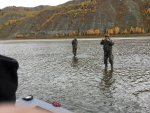
I was headed off for a week of hunting/camping with my parents, brother and some friends a couple weeks ago in Northern Alberta. I hadn't talked to them in a couple days but they get cell reception in most areas, not in the deep river valley of the peace river however. On the day i was to drive half way, i got an email:

As you can see, all I got was "help" and I am not familiar with Garmin InReach software....
After about 10 minutes I figured out how to find the lat and long on a google map, then figured out I just needed to click the garmin link to find the same location... In the middle of the river, 9 hours drive away. And I have no boat.
Cont'd:
I was headed off for a week of hunting/camping with my parents, brother and some friends a couple weeks ago in Northern Alberta. I hadn't talked to them in a couple days but they get cell reception in most areas, not in the deep river valley of the peace river however. On the day i was to drive half way, i got an email:
As you can see, all I got was "help" and I am not familiar with Garmin InReach software....
After about 10 minutes I figured out how to find the lat and long on a google map, then figured out I just needed to click the garmin link to find the same location... In the middle of the river, 9 hours drive away. And I have no boat.
Cont'd: