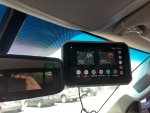
It's real a nice unit. Mounted it up on the windshield with the suction cup mount and it was rock solid for the couple days I had it up there.
Initially the map was showing dropped areas in Utah (areas that I have visited and want to look at on the map) and a reboot didn't help.
So, after creating a Garmin Explore account, and adding the device, it showed up as a "Beta" unit, I did a system update and that fixed the map issue. Then I loaded some USGS Quad Sheet maps and Color Aerial Imagery for some areas also. No problems there. Easy to see and read.
Tried loading some Kmz files I'm putting together for a North Rim trip. No issues there either. Load it, select your track from the menu, and off you go with the same perspective/view angle as regular "street view" except it's using the topo so you're driving thru modeled terrain.
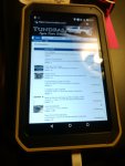
It does have a browser so, it can be used for browsing the interwebs too! Although, i thought the resolution could be a bit better for that.
For the short time that I had it, it did anything I wanted it to do and, overall, I actually like it. It's very user friendly and I could see it being very useful.
Now, do I like it enough to spend $700?? I would say, probably not. For my budget, that's a lot of $$$ for something that I would use a few weeks a year. Although, if I were a full timer, our even retired where I could get out more, I would seriously consider it.
View attachment 522041
View attachment 522042


