Getting lost around Lake Topaz NV

UncleChris

Adventurer
I had signed up for the WineCountry RockKrawlers Mustang Run along with a friend. This is a run out of Reno on a 4wheel drive trail to Virgina City.

Thinking it was a good time to take a few days off from work, I took Friday and Monday off to expand my adventure.

Coming over Carson Pass on Friday afternoon with no real places to be, I scouted out Jack's Valley OHV area outside of Carson City. Since it was pretty rutted from the rain, I marked it on the GPS and moved up to Hwy50.

I thought it would be a good time to do a recon of the Pony Express trail, so I drove on to Dayton and took the Fort Churchill Rd and hit the dirt. THis is a gravel\dirt road that goes along the Carson River and has some pretty cool Nevada desert scenery. It also goes by the Army Motor Vehicle test area, where they had some HMTTs, although they weren't on the offroad course(that would have been cool).

As we pulled into the Fort Churchill site, it started to drizzle. Let the dog run around a bit there and checked out the ruins, but since there were still miles to go, we hit the road again. Pulling onto 95a we went south to the Lahontan Rec area, and followed the simpson road(?) out into the desert. Although rutted in places, it was a fun drive. Once we got near Hooten Wells, we turned around to see a deluge to the west(over Carson City). Since we were out in the Boonies(the dog and I) and rain was coming to the Alkali flats I figured that it would be prudent to head back to the pavement. As we pulled back onto 95a, it started to come down pretty heavily(timing is everything)

We then headed back to Carson City.
 

UncleChris

Adventurer
4/22 Mustang Run

Hooked up with a group of about 50 vehicles to take a 'SUV' run from Reno up to Virgina City via jeep trails.

The night before it had been raining, but at the start the trail was pretty tame. At one place a Denali got stuck, but with a little throttle we all got through it. Stopped in Bronco canyon, Wild horses were all over along with the smell of fresh sagebrush.

As we got higher, ~7k' it started to rain, no pour. The rest of the trip became a mudfest with slippery mud. At one point there was a rut that basically you rode out. A ZJ lost a bead in the mud and had no choice but to fix it there in the downpour. Other than that, everyone made it through.

That night I headed down to Topaz to hook with my friends Bob and Dee, their dog Amy and their Rubicon.
 

UncleChris

Adventurer
4/23 - Burcham Flat, Rodriguez Flat, Desert Creek Canyon

On Sunday, we thought that we would go out exploring.

We had planned on hooking up with locrWln, but unfortunately he had hurt his back the other day and was out of commision.

We took a slow approach to the day, and hit the trail around 11.

We entered Burcham flat road out of the town of Walker off of 395, and watched the Walker River Canyon as we climbed. The road seemed to be in pretty good shape, until Bob made a comment about the mud my wheels were kicking up. We made it through a few areas of light rockfall and we were taking in the incredible scenery until things started getting pretty slippery. At that point we both had a novel idea, 'why don't we air down'. As we walked around the vehicles to let air out, we were surprised at how mucky the road was. As we climbed some more we encountered snow. We both tried getting through it with our lockers on, but it was too steep, and we did not have enough momentum. We decided to walk it to see what was up ahead, and right after this snowfield was another. Since we had promised ourselves no drama today, we decided to head back down. As we headed back down, we got hit again with a torrential downpour. We had stopped at 7.4k'.

Since it was still early, we thought we would head over to Rodriquez flat, go down the valley and hit 89 back to Topaz. Unbeknownst to us, 89 was still closed.

We took the road which was in pretty good shape. At one stream crossing, we even saw a guy panning for gold!.

Pretty uneventful, but at 7.3k' I made the comment 'looks good, no snow' and sure enough at 7.4k', trail was blocked again.

Still wanting to explore, we headed back to Walker, crossed the Walker river and headed out to Eastside lane which parallels the old Sonora Pass Wagon trail.

We took a turn off onto Riuse canyon road, hoping to hook up with the Desert Creek road up ahead. After driving through a herd of sheep, the trail climbed through the desert canyon. As we passed ghost towns and rain came and went, we finally crested at 7k' with no snow(whew). THe trail now descended into Desert Creek canyon, where we ended up fording desert creek multiple times. Although it was much deeper than we thought it didn't cause any problems. We came out at Desert Creek Ranch to see a herd of wild mule deer, and talked to the owner of the ranch who was from Morgan Hill, CA(10 miles from my house!).

We had dinner in Wellington NV(Dee had the Beef Wellington) and headed back to the hotel.
 

UncleChris

Adventurer
4/24 - the Como Trail!

Last day, so we decided to check out the trail that locrwLn suggested.

We drove out of Topaz up to Wellington and drove along the eastern edge of the Pine Nut Mountains. The road went from pavement to gravel to washboard, after we aired down for the washboard and finally right after the Mason Pass turnoff it turned into ......mud.

Bob and Dee were a little concerned when they saw the rearend of the taco slide to the trees. Elsa(my dog) started rolling her eyes. No problem we are now in 4wd.

So at the cattle pen, we are debating Sunrise Pass(unknown altitude) or Como trail(7k') Como will kick us out to Dayton, Sunrise will kick us to Minden.

We decided on Como, as hey, the map says it is a NV state road!

Shortly after the turnoff, we start hitting rocks. Then big rocks. Then Big rocks with Ruts. Then a ford with rocks. By this time, the dog is in the back seat burying her head under the blanket. I am running my p-Series Revos wondering if this is such a good idea. We are out in the boonies(see my stupid Radio Tricks).

We come up to a Chain link, fairly new fence. At this point I mention to Bob that the road has to improve now as someone has to be using it.

Unfortunately it now turns to mud. Mud with not ruts, but Ravins, with Rocks. Ravines so big you have to choose between putting one wheel in and driving at a crazy angle, or try to ride the shoulder and risk the momentum of sliding into it. Bob is asking me if I am locked, I am not. it is the kind of mud, that you do not want to stop, for fear of not being able to get going again. Occasionally the road gets better and dries out, only to through a deeper rut at you as you turn the corner. For some reason, we think we are the first ones through this year. This whole section had no trees on the side of the road. After the fact, Bob made the comment that this would have been PullPal territory for the lead vehicle if we'd been stuck.

Finally, after miles of this, we come to a section that we need to clear to get to the better road. The shoulders are limited by greasewood, there is rut filled with branches on the right, and a slope out of the rut on the left. SO I head up the left side into a bowl of soup. I back up, lock and take a run at it again to make no progress. I get out of the truck, only to sink in the goo. both feet are sinking as I am fighting to get to the front of the vehicle to assess the situation. Luckily, the winch remote is on the passenger side. As I open the passenger side door, the dog thinks that it is a good time for walk.

No way! I tell her to stay and grab the winch remote.

Luckily there is a tree nearby that we can run a strap around, so the winching part is easy. We thought about the waffleboards, but the back of the truck was in goo and the winch was close to dry ground. Our blessed lady of Warn don't fail us now and we are out back on the trail.

Bob, ever the quick learner, decides that the brush in the rut is there for a reason, and strolls throught the brush filled ditch to the right, both lockers on with his 33" MT.

After that the trail got much better, we got to Como, much to our surprise the road we were on was signed as a NV state road(go figure). We let the dogs out to run(Elsa did not want to get back in the truck) and hung out in the lack of ruins for a bit.

The trip down to Dayton was uneventful, but there were more rocks, and rocks with ruts....etc, but thankfully no mud.

As we neared the bottm, there were some strange Nevadans who had obviously been stuck for a while. We gave them a tug and got them on their way.

We finally got to Dayton and aired back up again. It suddenly occurred to me that we did the whole trail with the Taco at 20psi(OOPs)

Trip back was fairly uneventful, except for the fact that it took us about 10$ worth of quarters at the u-wash-it to get the goo off the trucks. I was a little concerned because there was mud clot the size of a football on my UCAs, and I had originally planned to swap them out this weekend.

It occured to me that the mud I got stuck in was gooey and bluish, kind of like the mud they ran into when mining for gold in the area. The gooey blue mud turned out to be filled with Silver. I was distressing to realize that the goo we washed off the trucks, might have had enough silver in it to at least pay the 10$ for the carwash!

By the time I got home, the mud on my socks was so dried and stiff that I could not take my socks off. I had to hose them down first.

Glad my winch worked and had a great time wheelin' with Bob and Dee!
 

UncleChris

Adventurer
Pics

Pics from the trip
 

Attachments

  • BurchamHi_0474_50.JPG
    BurchamHi_0474_50.JPG
    155.7 KB · Views: 92
  • DesertCreek_0478_50.JPG
    DesertCreek_0478_50.JPG
    244.6 KB · Views: 46
  • Burcham_0470_50.JPG
    Burcham_0470_50.JPG
    260.8 KB · Views: 65
  • IMG_0445_40.JPG
    IMG_0445_40.JPG
    118.2 KB · Views: 56
  • IMG_0467_40.JPG
    IMG_0467_40.JPG
    155.3 KB · Views: 41
  • PostComo_0485_50.JPG
    PostComo_0485_50.JPG
    239.7 KB · Views: 70
  • Topaz_0481_50.JPG
    Topaz_0481_50.JPG
    179.9 KB · Views: 49

BajaTaco

Swashbuckler
Nice trip report. Very cool photos. That is such a nice looking Tacoma & Jeep. That first pic is really cool. Hopefully the trails will recover from your escapades :Wow1:

UncleChris said:
As we neared the bottm, there were some strange Nevadans...

Care to elaborate? :p
 

UncleChris

Adventurer
BajaTaco said:
Nice trip report. Very cool photos. That is such a nice looking Tacoma & Jeep. That first pic is really cool.
Thanks BajaTaco

BajaTaco said:
Care to elaborate?
As we neared the bottom of the trail, there was this Full size blazer on the side of the road and a guy playing with a kid in the middle of the trail. It looked like they had been there a while.

I pulled up next to them and asked them if they needed help, and saw that they had a wheel buried. I told them that I would give them a tug and pulled forward to see a guy underneath the vehicle on a few blankets with a floor jack. As I set up to pull them out they pulled out a Tie-down strap with a ratchet as a tow strap. I asked them what is that? They replied it is their tow strap.

With that big ratchet on? I had visions of the ratchet breaking and causing all kinds of damage.

In the meantime we got out a real tow strap and a receiver hitch shackle.

As we were prepping, they kept telling us they got stuck getting out of our way and that they were big time ATV'ers. We really didn't care, but we saw them from way up on the mountain and they had been there quite some time.From the way they were trying to get out of their stuck, they didn't really seem like they were the ATV type.They kept repeating their story, multiple times and we didn't really care.

The ground they were on was completely dry and I figure that they were just trying to spin their wheels to get their yayas and dug themselves in. So we gave em a yank, and got out of there.

I figured they were there just to give us a Carlos Castaneda experience for the trip:rolleyes:

BajaTaco said:
Hopefully the trails will recover from your escapades

The trail was a really weird kind of mud. It wasn't deep(except for where I got stuck) but was extremely slippery. If you look at the picture of the taco with the moutains behind, that was about the depth of the mud on the Como trail. At a few places where we had dry ground we stopped and checked back on the trail to see how deep our tracks were. We were kind of amazed that the mud was not that deep, but slick as we couldn't believe. It could be that the ground was still frozen.

We hit the really nasty stuff when we were past the halfway point. We were fully expecting the trail to get better as we were getting closer.The miles of the high angle rocky parts were not something we wanted to go through again and the ravines were the real problem. With one set of wheels on the slimey ledge and the other in the ravine in the taco, well it was a little bit disconcerting.

I'ill probably think twice about early season wheeling next time. With all the rain and the melting snowpack(We figured that at 7k' that there was a snowpack a week prior to this adventure), the conditions were a lot messier than we thought they would be. Although we had fun and we were able to get through it, We were in a little bit deeper than we wanted to be. Bob and I both agreed that it was a little bit more on the extreme side than we had wanted.
 

FortyMileDesert

Adventurer
Lava Beds Trek No. 2

11 March 2006 - - Lava Beds Again – This Time with Snow.

Trail Boss: Rocky in the ’04 Discovery
The Team: Brian and Nancy H in the ’02 Freelander

- - -

Preamble: A four day continuous snow storm in the Sierras led up to the start of this trek. What began as a group of about ten rigs the week before was down to perhaps seven by Wednesday evening when I was last able to check out the 4playora club and MO websites. Checking the various weather reports, I found that there was possibly going to be a window in the weather Thursday morning and that the snowstorm was returning with a vengeance Thursday evening.

I left at about 6:30 am Thursday. Once past Colfax, it was just me, a few other 4wd and lots of trucks. As usual, they were checking the trucks to see that they were carrying chains at Applegate. The signs on the highway and the CalTrans lady on the radio said that chains were mandatory from Nyack to Truckee. This does not mean four-wheel-drive with snow tires. Anyway, I started hitting snow flurries at about 3500 feet. At Colfax it was snowing pretty hard and there was about 3 inches of snow plus that CalTrans special blend of sand and urea on the highway. Everybody but me stopped to chain up. It took less than five minutes to get passed the CHP checkpoint. From then on it was 25 mph on up to the summit.

At Kingvale, it seemed as if there was about four or five feet of snow accumulated and maybe 5 inches on the road. The driving was sweet. I stopped at the Summit Rest Stop to make room for more coffee. Maybe 5 trucks and me there is all. It was about 19 degree outside. At about the Donner Lake Exit the trucks all stopped to remove chains and it was on towards Reno at maybe 40 miles per hour. The road mostly clear of snow but had to be careful of black ice in a few places.

Just past the state line at Verdi, I stopped at Gold Ranch for breakfast. On a scale of 1 to 10, perhaps a 3. Here the sun was shining and it looked like a beautiful day ahead – but there was that big black cumulo-nimbus just behind me, heading east. Then it was on through Reno, Sparks and headed down the Truckee Canyon to Fernley.

As I approached Wadsworth the storm caught up with me; forty mile an hour NW winds and heavy snow. Throughout the rest of the day, Fernley accumulated about five inches of the new stuff. The temperature tumbled from about 30 degrees to about 16 overnight.
Friday morning was bright sun and the temperature shot up to about 36 during the day. There goes the snow! However, I could see several snowstorms passing to the north throughout the day; perhaps from the south end of Pyramid Lake and on up to the Gerlach area.

Friday evening I got hold of Brian H and met him and Nancy for dinner at about 6:30. We finally got hold of Brian M at about 7:15 and found that he wasn’t going to be able to make it. In fact, everyone had bailed out except for the possibility of Tim (Brian doesn’t have privy to the 4playora website – YET). End of Preamble.

PICTURES AT:

http://www.pbase.com/brhunt/lavabeds_camp

AND:

http://rvm.tcomeng.com/yappa-ng/index.php?album=/Rons Adventures/Snowy_Lava_Beds

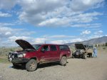
It’s Saturday morning and I’m up at 6:00am. Lot’s of time to kill as I’ve already packed the truck last night. So I do a leisurely breakfast at Pioneer Crossing (Way better than Gold Ranch-Not as good as Jakes - Nothing to compare to Thunder Mountain Café in Quincy (TM = 9, Jakes=7, PC=6, GR=3). Then I gas up, hook up the GPS and arrange the stuff I want handy on the right hand seat. So I’m sitting at Jakes a bit before 7:30 waiting for the rest of the gang. Brian and Nancy arrive about 7:45 and we wait a bit more for Tim. 8:00am no Tim. 8:05am color us gone!

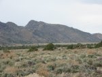
A bit west to Wadsworth and we catch 447 and head north to Nixon. From Nixon we continue north along the western shore of Winnemucca Lake with the Lake Range to the west and the Nightingale Range to the east. About halfway along Winnemucca Lake we stop at Nugent Canyon at the foot of Tohakum Peak (8182’), the high point of the Lake Range.

We drive up a side road to some tufa formations where I get a chance to explain what they are and how they formed under the surface of the Lake during the pleistocene (ice age) when the lake was about 350 feet deep. By 1932 the lake was only about 20 feet deep and finally there was not enough water flow in the Truckee to support both Pyramid Lake and Winnemucca Lake. At that time the channel to Winnemucca was blocked and all of the water now flows into Pyramid.

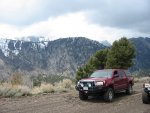
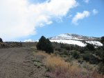
We head on north passed the end of the dry lake and are now abreast of the snow covered Selenite Range and where we are encountering deepening snow along the road. At the point opposite the pass over the range it’s pretty obvious that the very slick trail above the Cowles Ranch will be dangerous so we continue north towards Gerlach.

About four miles before Gerlach we turn east onto Route 48, a maintained gravel road that parallels the Western Pacific Railroad to Winnemucca, about 100 miles to the east. The road is very ‘washboardy’. Thankfully, there’s about five inches of fresh powder on top to cushion the jarring affect and fills some of the chuck holes. There are no tire tracks, we get to make them. After about ten miles we reach the northern end of the Selenites and turn south down the Teomile Valley.

The road down this valley is much smoother; it’s on frozen mud, no gravel, no ruts, and no tire tracks. At the low saddle between Dry Mountain to the east and Selenite to the west we pass a truck going north. Probably a rancher going from Lovelock to Gerlach – This road would save him about 100 miles. At one point I hit a slick spot and fish-tail. I recover and decide it’s time to slow down a bit. Eventually we come to the junction just north of Twin Buttes with the sign. Here we turn east.

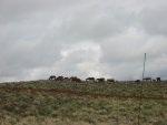
This road is a bit more up and down and twisty. Time for LO Range and lock in the CDL. At a low spot about five miles along we come to about twenty cattle in the middle of the road, naturally, and at a spot that is a large frozen over mud puddle about fifty feet long. I slow down hoping they’ll move out of the way and I can still keep up a bit of momentum to get through the mud. No way; the last cow still in the puddle waits for me to come to a dead stop and then finally moves on. Its rooster tails and traction control lights – and the truck claws its way on out of the mud puddle. In the rear view mirror I watch Brian bash his way through. OK. We’re dirty now and it’s time for fun.

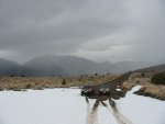
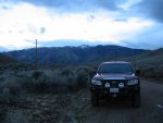
About eight miles from the signed intersection, and just about two miles from Lava Beds Camp we come to a shelf road down into the Lava Beds Creek Valley. Two weeks ago this was dry and no big deal. Now it’s covered with snow and just a bit intimidating. No problem, we just do it very slow and eventually arrive at the turn south towards the camp.

The trail over the rim into the camp has some very deep wheel ruts which were easy to stay out of when it was dry; not today! My wheels flop right in and I gun it up the hill. I watch Brian in the mirror and can see that he’s dropped into the rut too. Over the radio I let him know that he still has about an inch to go before bottoming on his skid plate. Then over the hump and down into the little box canyon.
 

FortyMileDesert

Adventurer
Lava Beds No. 2 Part 2

From my description two weeks ago: Lava Beds Camp is a picturesque bowl shaped canyon in the heart of some ancient eroding granite formations. To the north Eagle Rock Springs Creek cuts a notch escaping the canyon. To the east and west are huge rounded granite boulders and slabs. To the south are very tall granite spires. There are several large corrals in the bottom of the bowl and a cabin and barn in the south west corner. Lava Beds is definitely a misnomer; this is most certainly a granite batholyth. We do a bit of exploring. The cabin is in excellent shape with a sign above the door labeled “Pete’s”, a broad deck in front, and weather tight and well stocked inside. Inside Pete has another sign stating, “Enjoy the place but leave it as good as or better than when you got here.” This valley is obviously the headquarters for the annual roundup.

We walk a bit upstream to look for the springs and decide that it’s probably another half mile away and a bunch uphill in the snow. We take some photos, finish off our coffee and munch down Nancy’s great banana nut muffins. Good stuff. The sun gets snuffed by a black cloud and it starts to snow lightly; time to get back in the toasty truck and head on down the trail.

Back over the rim, I stop for some pictures and point out the side road climbing up to the rock spires that we climbed last time here. Not today! I have also decided that we are not going up to the Garret Mine and Windy Hill Mine today. They’re not that big a deal plus the snow covered climb could be hairy, not to mention trying to turn around up there if we even make it. This time I want to explore the huge spires that we can see to the southerly part of the Lava Beds. According to the map, a 4wd road approaches from the north up to Turtle Rock Spring and another 4wd road from Kumiva Valley comes up Trail Canyon, passes Mustang Spring and also approaches Turtle Spring from the south. There is a ¼ mile space between the ends of the two roads that only shows a creek bed on the map. Many times in Nevada, this situation is actually a trail.

We head south along the trail. After passing the turn-off to the Windy Hill Mine we continue south. The road immediately gets more primitive and it begins to snow in earnest. I even hear a comment over the radio, “Now this is wheeling!” My sentiments exactly! We continue on for about a mile and a half with a great view of the spires in the distance and the rock towers backing the Lava Beds Camp Valley to our right.

Eventually we come to a BLM Wildlife ‘comfort station’. Basically a spring that is protected from the larger hoofed animals (cattle, horses, burros, deer, antelope) and meant for birds. From here the trail is mostly just the creek bottom. Pretty soon I have to go a bit off-camber to the right to stay out of a three foot deep drop into the creek and wind up in a wide flat spot in the creek bottom at THE END OF THE ROAD. As I stop I hear over the radio, “Help, I’m stuck!”

In the mirror, I can see that he slid out of my tracks into that 3 foot deep notch. He’s sitting pretty solidly at about a 35 degree off-camber with both left side wheels in the hole. He’ll keep – and I get out exploring, on foot, to see if the road really ends here. Yes, it really does. The creek is now just a very tight notch that is between 45 degree banks, covered with six foot tall solid sage. OK, it’s time to check out the Freelander.

It looks as if this shouldn’t be too tough. I back up to the length of Brian’s recovery strap and I still have about twenty feet of pull space before my Discovery noses into the brush at the trails end. Piece of cake, we get him unstuck on the first try. We unhook and I have just enough room to back to the side of him at a 90 degree angle. He pulls into the space I just vacated and then I’m able to pass behind him and back across the off-camber spot again and stop to watch him in the mirror. He turns around, and this time goes much higher and makes it across without side sliding. So we learned something here: The MT/R’s are more prone to sliding sideways than the Rugged Trails are.

Now since we cannot get to the Mustang Spring trail from here, its time to backtrack all the way to the signed junction. It’s pretty easy going, just following our own tracks back out and on past the Lava Beds Camp turn-off. Up the off-camber, snow covered, shelf road is still no problem. We just take it slow and careful. As we get nearer to the cow herd mud holes, I start having traction problems with the Rugged Trails. The sun is out full force, the temperature is up a bit, the snow on top of the road is melting rapidly and the frozen mud is turning to slop. I’m doing a bunch of fishtailing, slinging mud like crazy and really doing a lot of work with the steering wheel to attempt to stay straight on the road. From the view in the mirror, the Freelander with MT/R shod wheels is staying much straighter. Now the score is:
Hippo with MT/R wins on straight ahead gooey mud.
Disco with Rugged Trail wins on off-camber snow.
I think the performance was a bit tough to compare since the two trucks were so different.
There were actually times when I did much better in a taller gear with the diff lock unlocked and let the 4ETC keep me straight. In those cases, the Hippos viscous coupler was an advantage. Climbing steeper slopes with mud that was a bit more frozen, the extra horsepower, lower gears and diff-lock had the advantage.

Anyway, back at the signed intersection, I decided that we would head south down Kumiva Valley to the corral at 40-18.8N and then turn west towards the saddle between the south end of the Selenite Range and the north end of the Nightingale Range, and make another decision there.

There are a lot of cattle in the Kumiva Valley this time of year! Well, at least by Nevada standards: The valley is about 20 miles long by about an average of 10 miles wide (200 square miles / 13,000 acres approx) and we saw perhaps 50 head. Lemme’ see; that’s about 260 acres per cow. Yep; that sounds about right.

At the corral, the road west was pretty faint. Maybe it was only used a few times per year. There was a gate through the barbed wire fence that ran north and south on the west side of the main road all the way down the valley; so this must be the road.

The road was pretty rough all the way to Jayhawk Well, but the gps said I was going the right way, so on we went. Jayhawk Well consists of a fallen down windmill; that’s all. We then continued on south to Stonehouse Canyon. When we got to the crossroads at Stonehouse Canyon it was already close to 3:00pm. I thought a bit about doing the road down the east side of Winnemucca Lake, past the MGL Mill and on to Nixon. It occurred to me that me, we might get about halfway down before sunset and then trying to do all those wash crossings in the dark could be really tricky. So, better safe than sorry, we headed northwest around the end of the lake and back to pavement in about six or seven miles.

We arrived back at Fernley at about 4:30pm after about 228 miles. It was a pretty good run.
 

BajaTaco

Swashbuckler
Hehehe - thanks for the elaboration. Sounds like it was a weird encounter for sure. A ratchet strap?? Oh man...

I know what you mean about the greasy thin mud.
 

Forum statistics

Threads
189,796
Messages
2,920,942
Members
232,931
Latest member
Northandfree
Top