Great Divide Trail from New Mexico through Montana

Luckytibbs

LuckyTibbs
This is the Great Divide trail used by Cyclists, but I started in Antelope Wells New Mexico and stopped in Montana, right at the border. I didn’t make it into Canada on this trip, I’ll do this portion next year. Close to 2500 miles and 80% of it on dirt. Easy roads, rough roads and shelf roads. A mixture of it all. I ran into lots of cyclists, and a lot of them women traveling solo! Lots of Continental Divide hikers as well. Everyone was having a good time, through all the hardships, it didn’t matter.

I traveled this trip solo, but with my two dogs, ChiChi and Gracie. We all did great. I’ll post a few days at a time as I’m still going through tons of photos and notes. But this is a really great trail, the scenery is awesome, and the history and people you meet are fantastic.

First, Antelope Wells. Quiet, not a sole in sight other than the Border Patrol that I passed. Not another single person. Beautiful desert with signs full of life. Hawks, deer and donkeys I saw on the very first day.

IMG_5192.jpg


M43A0308.jpg

Then we traveled through Hachita. Never saw a soul.
IMG_5191.jpgIMG_5205.jpg

On to Silver City and the Gila National Forest
 

Luckytibbs

LuckyTibbs
Days 2 and 3

We spent the next couple of days traversing the Gila National Forest and the Plains of San Agustin before moving through the town of Mangas. All the roads were dirt, some slow moving through the Gila but not too bad. Rocky sections followed by mud and sand. The coyotes were really active our night in the Gila, then We saw our first Antelope in the Plains. This is the history I found about the town of Mangas:

Mangus, also spelled Mangas, took its name from Mangas Colorados or Red Sleeves, an Apache chief murdered near Pinos Altos in 1863. After coming in under a white flag and in good faith, Mangas was later tormented by soldiers and when he protested they shot and killed him.

After his murder, Orson Squire Flower, a phrenologist-lecturer, had Mangas' head severed from his body and boiled out his skull to use in his lectures; his body was thrown in a nearby ditch afterwards. The disrespect showed the Apache chief caused "bad blood" between the tribe and soldiers for the next 30 years.

There were still people living there at Mangas Springs.

M43A0356.jpgM43A0351.jpgM43A0334.jpgM43A0327.jpg
 

Attachments

  • M43A0356.jpg
    M43A0356.jpg
    25 KB · Views: 817

Luckytibbs

LuckyTibbs
Hi Debbie,

I look forward to the report. :drool: I have subscribed.

I know you and your kids were gone a long time and all returned safely, I hope.

Frenchie

We did Frenchie, thanks! Had a super time, first time the dogs have been gone that long and they just traveled like troopers!!
 

Luckytibbs

LuckyTibbs
Days 4 through 7

We traveled from the Plains of San Agustin, then Pie Town which is just a little gathering place for the locals. We had to travel to Quemado to get gas then up to El Malpas National Monument with has the Chain of Craters Backcountry road. Warm but beautiful! The lava rock was fascinating and also the Ventana Natural Arch. We made it through the Santa Fe National Forest through Cuba. Below are some pics of the nice roads in the Santa Fe before we hit our first challenges. I won’t forget FS 144 in quite a while. It was tough. Took me 8 hours to go through this trail. I don’t know how cyclists do it because there was rock field all day. Then we moved on into the Carson National Forest area and that is one of my personal favorites. Cabins along the way of old Homesteads. Our camp site was the best. We had a view to end all views and we also got to see the Cumbres Toltec Train go by in the distance. Then on into the Rio Grande National Forest where there were just tons of fly fishermen.

M43A0396.jpgIMG_5256.jpgIMG_5279.jpgM43A0423.jpg
 

Attachments

  • M43A0416.jpg
    M43A0416.jpg
    10 KB · Views: 747

mkitchen

Explorer
Sounds like a fun trip

I have been thinking about doing the Great Divide trail by motorbike, I have never considered doing on four wheels. Looks like it would be a great trip either way. We are looking forward to your next entries on your travels.
Mikey
 

Luckytibbs

LuckyTibbs
I have been thinking about doing the Great Divide trail by motorbike, I have never considered doing on four wheels. Looks like it would be a great trip either way. We are looking forward to your next entries on your travels.
Mikey
Thanks Mikey, you will enjoy the route completely! There is so much to see and do, give yourself time. Passed a lot of motorbike riders. Hope you do it. You won't be sorry.
 

Luckytibbs

LuckyTibbs
Days 8 through 15.

I moved into Colorado by this point and the Rio Grande forest and the San Juan Mountain range. Just gorgeous. Tons of fly fishermen in the Conejos River. Saw plenty of homesteads and just grave sites with nothing around them except for the small fences and some flowers. Someone out there still pays tribute to our pioneers. This one was close to Cox Ranch. Plenty of old mine sites and even passed by the Summitville site. Sad what we can do to our own country. But the passes in Colorado are just beautiful. Mosquitos galore though, so be prepared. FS 11 is a big shelf road, and is remote. Runs through the Radium State Wildlife area. I didn't hit any rain while in Colorado, but the nights got down into the low 30's. Dog water bowl had ice in the morning. Roads were pretty good overall. Marshall Pass road in the San Isabel forest is just stunning. And no one there! Stumbled upon this. The Rock Creek Stage Station.

Originally built by James and Katherine Gates in the 1880s, the Rock Creek Stage Stop served as a family home, hotel, post office, and stage stop. *It was a halfway station on the first Wells Fargo mail route into Yampa Valley and as a service center for settlers until the railroad line took over in 1887. Travelers going between Steamboat Springs and Kremmling stopped here before continuing their journey. It sits on what used to be the main road until the road was improved and moved in the 1950’s. I ventured into Yampa to the Montgomery’s which is the oldest functioning mercantile in Western Colorado. What an experience. The old wood floors from my youth! But went through many, many old towns, Como, Breezed through Steamboat Springs. I’d been out in the forest now and even the smaller town of Steamboat had too many people for me. I wanted to get back into the open land with few people. Hit the Elkhead mountains moving into Wyoming.

IMG_5284.jpg
Stunner Pass
IMG_5336.jpg
Marshall Pass Road
IMG_5362.jpg
Borreas Pass
IMG_5393.jpg
Rock Springs Station
M43A0593.jpg
Barn at Steamboat Lake
IMG_5415.jpg
IMG_5418.jpg
Yampa Colorado, notice the dirt streets!
 

Luckytibbs

LuckyTibbs
Days 15 through 30

Day 15 through 30th.

Made it through Wyoming which was a mixture of Forest, then the Great Divide Basin which has to be the most isolated I have ever been. Parts of this area is totally flat and you won’t see another soul. Nothing except antelope. Not until you get to South Pass City, where you start getting into the Oregon / Immigrant / Mormon trails. Very interesting. Saw the ruts from the Willy’s Hand Cart Company along with their memorial dedicated to the ones who lost their lives. This was still isolated and arid land. You could look off into the distance and see the Wyoming range in the distance. I spent some time in this area driving to some of the various old stage stops, what is left of them. It didn’t rain when I was in this area, but if it had, it would have been impassable.

The trail then led up past the Grand Tetons and just south of the Yellowstone National Forest. I planned on coming back though this way when I returned south so I didn’t explore this area until I was heading south again.

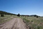
When I explored I found free campsites with killer views of the Tetons right across from the national park in the forest. www.freecampsites.net. Fantastic site. All the roads are really pretty good gravel roads. I spent some time close to the Tetons though. I explored the Grey River Valley area and the Gros Venture wilderness. Both of these are absolutely beautiful and worth a lot more time than I gave them. I plan to go back. The Grey River Valley, the southern portion of it became one of my absolute favorites. The road is a little narrower and a bit rougher but that leads to more isolation. I had deer and a moose in my camp.

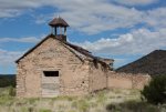
I continued past Yellowstone National Park and spent a very short time in Idaho where I hit Montana. I traversed through the Centennial Valley and it was magnificient. Especially the history. The cemeteries that I came across have been adopted by some of the local groups who have taken the time to research and list who is buried there. You can see that living in the west was harsh. Moving up through the valleys through the Beayerhead Deerlodge National forest and the Helena National Forest. I took in some local sights and saw quite a few mines and some old charcoal kilns. Fascinating. I did hit the little town of Rimini, but before that was Helena FS 299 which I would bypass in the future if I’m pulling a trailer. This had a very small portion right before Rimini that was a shelf road, but way too skinny and part of it was washed out. I made it though, but doubt I would do it again. There isn’t any room to backup a trailer if the road was washed out.

I wound the way up through the Lolo National Forest then the Flathead up to Eureka Montana where my time was already at 30 days so I didn’t go all the way to Banff. That will be another trip. I had to head back home.

But one thing I learned about this whole trail, you need at least 45 to 60 days to do this justice. Even driving. There is way too much to see. You need time to explore. A couple of times I had to backtrack since I hit closed gates in the forest. Some were recently closed because they were protecting habitat for grizzlies. But this trail is FULL of history. One day you can do 150 miles, but the next, you may do 40. Some rough roads, but mostly good travel. Some shelf roads, so be prepared. I will do this again, but I think I will break it up. The southern portion, in southern New Mexico I want to go back and really explore. Look up the old town of Hachita and go back to the Craters plus Chaco Canyon. But this is better in the winter months I think, when it is cooler.

Up in northern Montana and Banff area, that is another whole place to explore. I met some of the nicest people, and since I was a female traveling alone, all kinds of people would stop to make sure I was alright if I was airing up my tires or checking pressures. There are a lot of good people in this country. But this trail is one to be put on your bucket lists for sure!

IMG_5445.jpg
Handcart ruts in Wyoming
IMG_5481.jpg
South Pass City Wyoming, Oregon and Mormon Trails
IMG_5543.jpg
IMG_5617.jpg
Flathead National Forest
IMG_5642.jpg
Clearwater lake, Lolo National Forest
IMG_5740.jpg
Charcoal Kilns, Beayerhead Forest
IMG_5799.jpg
Free Campsite across from Grand Teton National Forest
 

Ace Brown

Retired Ol’ Fart
I just now found your report; great write up and excellent photos. As you know I had planned to do this a few years ago but dropped it when I could not find anyone to share. Bravo for you doing it solo.
 

Forum statistics

Threads
188,727
Messages
2,909,549
Members
230,891
Latest member
jesus m anderson
Top