HEMA Explorer North America

shane4x4

Supporting Sponsor
Wow...a guy takes a few days off & this thread goes nuts :)

Ok...I know there are several Gaia fans around here, that's cool.

I think (and this is my opinion) that the Hema team in AU has been going in MANY directions that have not allowed them to devote adequate time to the NA app, so that's why we haven't seen an update since May. I do know that they're working on the glaring issues that have been addressed, and that an update is coming.

As Kurt pointed out, Hema has been mapping the Continental Divide Route since the week after Expo (my family & I did 6.5 days & 1,100 miles last month) and will soon map an all-new overland route down the west coast of the US and into Mexico. This is a small company, so when there is that much going on, things don't happen as fast as any of us would like.

I mentioned before that Hema is in this for the long haul and they will build the bespoke platform for vehicular based travel. While other platforms may improve to include vehicle adventure, there is only one mapping company on the planet that has the chops to do it right. They will.

In my best Yoda:
"Be patient my friends"

=)
 

MountainBiker

Experience Seeker
I mentioned before that Hema is in this for the long haul and they will build the bespoke platform for vehicular based travel. While other platforms may improve to include vehicle adventure, there is only one mapping company on the planet that has the chops to do it right. They will.
Sure, it's possible that they'll get it worked out. I'm currently planning a 10 day trip through the Arizona Strip and Utah, and I'm heading out in 2 weeks time. So I need something that works now. And I have 3 additional week long trips coming up before June '17.
 

cruiseroutfit

Well-known member
Sure, it's possible that they'll get it worked out. I'm currently planning a 10 day trip through the Arizona Strip and Utah, and I'm heading out in 2 weeks time. So I need something that works now. And I have 3 additional week long trips coming up before June '17.

What about it isn't working for planning that trip? Are you using iOS or Android? I lead a similar trip with ExpeditionOverland and Toyota using HEMA as my only mapping, worked great. Perhaps we can solve your issue?

image.jpg
 

1Louder

Explorer
What about it isn't working for planning that trip? Are you using iOS or Android? I lead a similar trip with ExpeditionOverland and Toyota using HEMA as my only mapping, worked great.

Been discussed at length in this thread. Android version you cannot move maps to the SD card to give you the ability to download a large amount of maps. Recording is only metric and cannot be change. So with regards to planning I would say it's the map storage issue.

IOS and Android I don't agree with how Hema defines map layers. In Gaia you set percentages and can truly use layers. You can have a generic Topo map as the main layer and another map either from Gaia or a custom map as another layer. Both visible at the same time. Some people like to blend a Topo map with satellite images at the same time. Hema can't do this with its "layers" option.
 

Roger M.

Adventurer
In simple "app" terms - when will we see a version update, and what will that version update include to address concerns of current HEMA customers?

That's all that's being asked.
 

cruiseroutfit

Well-known member
Been discussed at length in this thread. Android version you cannot move maps to the SD card to give you the ability to download a large amount of maps. Recording is only metric and cannot be change. So with regards to planning I would say it's the map storage issue.

Right, assuming he is running Android. I'll concede he must given his comments.

IOS and Android I don't agree with how Hema defines map layers. In Gaia you set percentages and can truly use layers. You can have a generic Topo map as the main layer and another map either from Gaia or a custom map as another layer. Both visible at the same time. Some people like to blend a Topo map with satellite images at the same time. Hema can't do this with its "layers" option.

And while that sounds like a neat feature (and I'm hopeful it's integrated) I can't imaging that having any real impact in planning a trip give how easy it is to zoom or toggle between the two in HEMA. Value added yes, critical to planning a route, no. Fwiw traversing the AZ Strip & Utah in 10 days doesn't leave you much time to get too granular with your routes, ie you could plan it all with a Benchmark Atlas too :D
 

1Louder

Explorer
And while that sounds like a neat feature (and I'm hopeful it's integrated) I can't imaging that having any real impact in planning a trip give how easy it is to zoom or toggle between the two in HEMA. Value added yes, critical to planning a route, no. Fwiw traversing the AZ Strip & Utah in 10 days doesn't leave you much time to get too granular with your routes, ie you could plan it all with a Benchmark Atlas too :D

Here's where I find it useful. I'm using custom maps that show the MVUM map as a layer and then USFS Raster or USFS Topo where there is no MVUM. I am hopeful Gaia will add this as a layer vs me building custom maps/layers. No reason why Hema couldn't either. Since MVUMs are becoming the law of the land it will be important and very convenient to have them in your primary navigation app. Sure once you are in the MVUM layer you could just switch but if you are on the edge of different maps layers are nice. In a different thread I have shown how that works.
 

cruiseroutfit

Well-known member
Here's where I find it useful. I'm using custom maps that show the MVUM map as a layer and then USFS Raster or USFS Topo where there is no MVUM. I am hopeful Gaia will add this as a layer vs me building custom maps/layers. No reason why Hema couldn't either. Since MVUMs are becoming the law of the land it will be important and very convenient to have them in your primary navigation app. Sure once you are in the MVUM layer you could just switch but if you are on the edge of different maps layers are nice. In a different thread I have shown how that works.

That would be awesome. I carry a MVUM or BLM TMP for anywhere I'm exploring, like you said THE law.
 

1Louder

Explorer
That would be awesome. I carry a MVUM or BLM TMP for anywhere I'm exploring, like you said THE law.

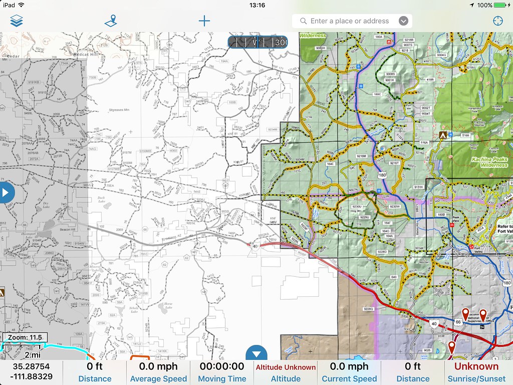
29344649693_43ff115afe_b.jpg

2 different MVUM layers

29379957774_cde6f7b13e_b.jpg

Topo and MVUM layer with MVUM at 100%. Reduce that to 75 and the white space on the left would go away.

Just remember this is with Gaia. I can't predict what Hema will do and I don't think they support custom map layers.
 

shane4x4

Supporting Sponsor
So how does the custom map layer work, ie how do you align the maps? Pic 3 points and calibrate?

"there are ways" to add custom maps to Hema Explorer, you basically need a geotiff -> map tiles. It's very map geeky and not within the scope of 99% of our intended users.

It's nice to have MVUM maps in the system, but there are 2 issues right now:
1) MVUM quality varies GREATLY within the US, and in fact only about 75% of USFS Ranger districts have published an MVUM. The data is not super reliable, but it IS the law =)
2) MVUM data (about 80% of what's been published) is available as a 'vector' layer, right now Hema Explorer (and Gaia, I think) only support RASTER layers, so in order to add the limited data that is available, someone would have to convert it all to raster from vector. That would take a long time, and $$. It would be better for the app to support vector layers.

You're right, Benchmark maps would be great to use in the app. Maybe we should talk to someone about that =)

Also, wouldn't it be great if someone were to combine all the available MVUM data with track data from the likes of TrailDamage.com, FunTreks.com, and several other data vendors. Then publish all that into a vector map that could overlay any other layer? The vector would be transparent so you coud have any baselayer you want.

Even better....combine all the above data with open streetmap data, into one epic OHV friendly 'feature' map? Then everyone could use the feature map + whatever other sources are available to plan, explore, and share epic OHV/off-road/overland adventures.

That would be cool =)

But hey, I'm sure all the other map providers are already thinking about this.
 

1Louder

Explorer
So how does the custom map layer work, ie how do you align the maps? Pic 3 points and calibrate?
If the MVUM is georeferenced properly I use a program called MapTiler on my Mac, I then upload the files to my Amazon server (there are other options like DropBox and Google), and then use the web based tool from Gaia to import the custom maps. Sounds complicated but once you have done a couple it is really easy. See other comments below... With a properly Georeferenced map I can complete the entire process including downloading the map to my iPad in like 10 minutes.
http://blog.gaiagps.com/import-custom-map-sources/ - Note this also works with map providers which can simply provide you with the proper URL. MapBox for example, HERE Maps, and a few others. Some require a free developer account.

"there are ways" to add custom maps to Hema Explorer, you basically need a geotiff -> map tiles. It's very map geeky and not within the scope of 99% of our intended users.

It's nice to have MVUM maps in the system, but there are 2 issues right now:
1) MVUM quality varies GREATLY within the US, and in fact only about 75% of USFS Ranger districts have published an MVUM. The data is not super reliable, but it IS the law =)
2) MVUM data (about 80% of what's been published) is available as a 'vector' layer, right now Hema Explorer (and Gaia, I think) only support RASTER layers, so in order to add the limited data that is available, someone would have to convert it all to raster from vector. That would take a long time, and $$. It would be better for the app to support vector layers.

You're right, Benchmark maps would be great to use in the app. Maybe we should talk to someone about that =)

Gaia supports vector layers.

The program I mentioned above does the required conversion. http://www.maptiler.com If the map is not properly georeferenced you can correct that within the app. That is time consuming but is possible. All of your other points are valid. I have heard that electronic versions of the MVUMs are available but have not been able to find the source yet. One challenge to the improvement of the maps may be that the government really endorses the PDF Maps app by Avena. So who knows if that will roadblock future innovation. I believe all but one of the MVUM maps in AZ are properly Georeferenced. With some limited testing I have found many of the older ones, which are still the current versions, are not.

I am hosting my files with Amazon S3 because it is super cheap and that is incorporated into the MapTiler program for easy uploading and processing. MapTiler has a free version and the lowest paid version is $29.00.

Here's a post from 2014 where Gaia states they support vector maps: http://blog.gaiagps.com/the-future-of-outdoor-maps/

Also, wouldn't it be great if someone were to combine all the available MVUM data with track data from the likes of TrailDamage.com, FunTreks.com, and several other data vendors. Then publish all that into a vector map that could overlay any other layer? The vector would be transparent so you coud have any baselayer you want.

Even better....combine all the above data with open streetmap data, into one epic OHV friendly 'feature' map? Then everyone could use the feature map + whatever other sources are available to plan, explore, and share epic OHV/off-road/overland adventures.
.

I would say Gaia is very pro to this idea and encourages folks to help with crowd sourcing data.
http://blog.gaiagps.com/updated-public-lands-in-gaia-gps/
 
Last edited:

1Louder

Explorer

Forum statistics

Threads
188,296
Messages
2,905,091
Members
229,959
Latest member
bdpkauai
Top