Input on Lowrance Baja 480C

crawler#976

Expedition Leader
Sold my Garmin Vista and Garmin Topo software!!! It was a great handheld unit, but it really wasn't suitable for vehicle use...either the screen was too small or my eyes can't focus at over 5 mph on dirt roads. :D

So, I've decided on the 480C, but really hope to get some user reviews/info prior to plunking down the $$$.

1. Software???

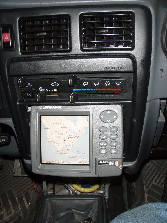
2. Toyota Tacoma mounting options???

3. Wiring - direct or cigarette???

4. Antenna placement???

5. SD card size, and/or how much data per map file??? Planning on a two week trip from Chino Valley, AZ. thru Nevada, Oregon, to Sedro Wooly, Wash., east to Glacier NP via Hwy 20, then south on Hwy 89 back to the house.

Thanks

Mark
 

Nullifier

Expedition Leader
crawler#976 said:
bummer dude.. the Baja model is sold out until next year!

.....but, the Lowrance 3500C is the same thing except badged for nautical use. So one of them is on the way!

http://www.gpsdiscount.com/products/index.html?p=877


Sold out till next year did you try gps city or any of the other sites? ANyway a 1 gig card should hold that area you plan to travel on one card. I eliminated my radio and flush mounted it in the dash. We had to trim some of the din and dash pieces and make abracket to mount it but I love the location. I plan on relocating the radio someday but it is not in my top 10 priorities right now.

f9490604.jpg
 

Steve Curren

Explorer
Not to butt in but I bought one here in Tucson and maybe they have them in stock, I got a good price too.
Mail me if you would like the company name.
Steve Curren
 

crawler#976

Expedition Leader
I checked several sites - they are being replaced by a new model for next year, and after the artical came out in 4wheeler magazine, they are going or gone...they had 8 on Friday - sold out yeasterday...

The difference is in the zoom ranges - the Baja has a 0.02 minimum, the 3500 a 0.04 minimum. The tech at GPS Discount said "ruggedizing" consists of a piece of styrofoam placed in the unit.
 

Steve Curren

Explorer
Great, I bought mine locally and was given quite a deal, I also was told that the entire unit is sealed against the dirt and dust. I have enjoyed mine and when I get to know it better I am sure that I will appreciate it that much more.
Steve Curren
 

crawler#976

Expedition Leader
wow!

Got the machine yesterday - looks like a small TV! It's heavy - gonna have to rethink my initial plans. I'll start on that tomorrow with pic's included.

Installed the MapCreate software and started loading maps onto a 1G SD card. I'd read a couple items on a GPS forum about keeping file sizes smaller than 250K to make the GPS faster at reading them, so I loaded them state by state in files about 150K or less. Got AZ, NM, CO, UT, So Cal/So NV, and Nor Cal/Nor NV on one card and still have 250K left for other data.

Mark
 
Last edited:

crawldit

Adventurer
Great choice with the 480c, I absolutely love mine. You're right about it looking like a little tv though. I have mine mounted on the windshield channel above the rear view mirror in my jeep. I actually got pulled over one night becaue the police officer thought I was driving and watching tv at the same time lol
 

crawler#976

Expedition Leader
After looking a many mounting locations, I decided to set the unit in front of the shifter. Looked at the dash above the AC vents, it covered up to much view. Took off the rear view mirror to check for an overhead mount - too many cables to deal with...

initial impressions:

BIG screen!

FAST initial sat tracking!

...gotta whole lotta learning to do!
 

crawler#976

Expedition Leader
I'm impressed with the unit. It's very user friendly - the unit software took only a few hours of use and reading for me to feel quite comfortable with the functions I use the most. Being able to have multiple maps displayed a different resolutions is cool. Also you can switch between same scale maps at full screen size with the push of a button.

The MapCreate software is also easy to use. Being able to use SD cards is a huge plus compared to the Garmin Vista I had prior. I've got the highest detail maps loaded for AZ, NM, CO, and UT on a single 1G card ans still have 250K remaining for user defined files like routes and waypoints. The unit locks onto satalites almost instantaniously. The software also has a massive point of interest database built in. Route creations is very quick, and since all user data is stored on the SD card, it's simple to upload/download routes and trails data.

Unfortuantely the map detail isn't as current as I'd like it to be. I've found several errors/omissions in detail at the state and local level, and that kinda bums me. The topo level trail/road is also not up to the Garmin level of detail.

The other "problem" is the sheer size of the unit. It's size limits mounting opportunities, but having a 5" x 5" display is well worth any difficulty.

Mark
 

Ryanmb21

Expedition Leader
Thanks for the response crawler#976....

this is a very tough decision, i've only begun my research. :088:
 

Forum statistics

Threads
190,464
Messages
2,927,843
Members
234,008
Latest member
zhukoveli

Members online

Top