deserteagle56
Adventurer
After my sat phone provider decided to double the yearly subscription on my phone this past summer I decided to give up the sat phone and bought me a Garmin Montana 750i. Not because I needed the camera...at the time there were no 700i models available. After 6 months of use I can tell you the InReach part of the Montana 750i works just fine, never had a problem sending or receiving a message. A year's InReach subscription is about a third of what a year's sat phone subscription would have cost me.
Initially I had problems with the 750i turning itself off. That was solved with the first software update Garmin put out. Also, the unit comes with what Garmin has named "Topoactive" maps. They are the most up-to-date topographic maps I've seen - but unfortunately, they don't show a lot of the back country roads I ride. Years ago I bought the Garmin 100k topo maps on a DVD; I loaded them on a microSD card and used them in my Montana 600. When I loaded that card into the 750i and tried using the 100k maps I had problems - not always, occasionally - where the 750 would refuse to bring up any mapsets at all until I rebooted it. After rebooting it would work fine...until the next time. Using a Garmin 24k mapset, newest version on a microSD card, did not cause any problems - it worked well. FYI, the 24k mapsets (at least for the "West" section) were updated I think in 2013 or thereabouts. I have the older version and was pleasantly surprised at how much more accurate, how much more useable data, there was on the updated version versus my old version.) Also, the 750i comes with Land Status map overlay which I've come to appreciate; it shows private versus public lands and as I ride in areas where there are a lot of both interspersed it helps a lot. The Land Status overlay will work with whatever mapset you use.
So - with the latest software update and the newest 24k mapset, the 750i works pretty darned good. I've not had the battery issues mentioned above. I can hike pretty much all day and the battery still shows 80% charge. Most of the time I use it in its powered mount, in my Jeep or side by side, so the screen is at full brightness and easily visible. Menus are not much different than with my old Montana 600 (which still works just fine, by the way) but you'll have to get used to "Recorded Activities" versus "Tracks". Just a matter of semantics and slightly different way of saving them.
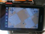
I would definitely buy it again. Below shot show my Montana 750i using the included Topoactive maps. White squares are private land (Land Status overlay selected). You can see my track on there and yes, I am on a road. It just doesn't show on the Topoactive maps.

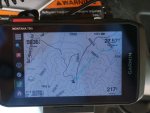
Switching to the Garmin 100k maps shows the roads (no Land Status overlay on this shot) :

Initially I had problems with the 750i turning itself off. That was solved with the first software update Garmin put out. Also, the unit comes with what Garmin has named "Topoactive" maps. They are the most up-to-date topographic maps I've seen - but unfortunately, they don't show a lot of the back country roads I ride. Years ago I bought the Garmin 100k topo maps on a DVD; I loaded them on a microSD card and used them in my Montana 600. When I loaded that card into the 750i and tried using the 100k maps I had problems - not always, occasionally - where the 750 would refuse to bring up any mapsets at all until I rebooted it. After rebooting it would work fine...until the next time. Using a Garmin 24k mapset, newest version on a microSD card, did not cause any problems - it worked well. FYI, the 24k mapsets (at least for the "West" section) were updated I think in 2013 or thereabouts. I have the older version and was pleasantly surprised at how much more accurate, how much more useable data, there was on the updated version versus my old version.) Also, the 750i comes with Land Status map overlay which I've come to appreciate; it shows private versus public lands and as I ride in areas where there are a lot of both interspersed it helps a lot. The Land Status overlay will work with whatever mapset you use.
So - with the latest software update and the newest 24k mapset, the 750i works pretty darned good. I've not had the battery issues mentioned above. I can hike pretty much all day and the battery still shows 80% charge. Most of the time I use it in its powered mount, in my Jeep or side by side, so the screen is at full brightness and easily visible. Menus are not much different than with my old Montana 600 (which still works just fine, by the way) but you'll have to get used to "Recorded Activities" versus "Tracks". Just a matter of semantics and slightly different way of saving them.
I would definitely buy it again. Below shot show my Montana 750i using the included Topoactive maps. White squares are private land (Land Status overlay selected). You can see my track on there and yes, I am on a road. It just doesn't show on the Topoactive maps.

Switching to the Garmin 100k maps shows the roads (no Land Status overlay on this shot) :


