Overland Route - Georgia Traverse

ramblinChet

Well-known member
Georgia Traverse

by Chet Szymecki​

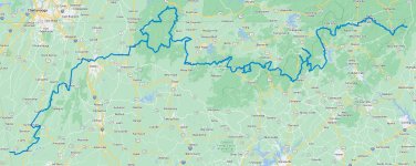
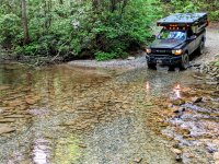
The Georgia Traverse is a 400-475 mile adventure that can last from three to seven days depending upon how often you stop to explore other sites along the way. Approximately 80% of the time is spent on dirt roads whereas the remaining 20% is spent mostly on two-lane paved roads. The route is designed to be driven east to west although since I was coming from the west I ran it in the opposite direction with no problems. This is in the northern section of Georgia so the terrain transitioned from hilly in the west to mountainous in the east. At times you will cross into Tennessee and North Carolina for short periods of time. You will spend much time in the Chattahoochee-Oconee National Forest in the center of the state. This was a fun adventure with approximately 8-10 water crossings and dozens of camp sites. All water crossings had an even rock bottom and were around one foot deep. I would recommend additional fuel storage since there are some sections where fuel may be 30-60 minutes away.

Here is a map of the 390 mile track as published by Georgia Overland in this article. A link to the GPX file can be found here.

main.jpg
 
Last edited:

ramblinChet

Well-known member
I took advantage of the optional loops and when finished, I recorded 463 miles traveled at 9.2 mpg and it took 29 hours. While researching this journey it seemed like approximately 1/3 of my time would be spent on pavement but that was untrue. My average speed off-road was around 10-12 mph while on pavement it was easily 50-60 mph. With that being said, maybe 4-5 hours out of the 29 was on pavement and that was intermittent.

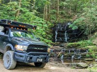
This was one of several beautiful waterfalls in the Cohutta Wilderness where I stopped to enjoy the sounds, smells, and cool breeze. just minutes after taking this picture I encountered the first of several black bear sightings.
image000000(222).jpg

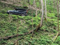
Much of my time was spent in mountainous terrain so switch backs and shelf roads were endless. It was lush and green and summer was a beautiful time of the year for this trail.
image000000(223).jpg

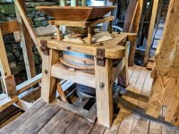
One of the unexpected benefits of traveling full time and not really having a schedule is that not only do I meet the most interesting people, but I can spend hours conversing with them. If you are near Suches, Georgia, stop by the Skeenah Campground and Mill and say hello to Brian. This mill was built in the mid-1800s on Indian land and has so much history.
image000000(224).jpg

Although the mill is currently undergoing repairs before it is reopened for tours Brian was kind enough to show me some of the work that is underway. Being able to see and touch tooling that was manufactured so long ago, that was driven by large belts, that were themselves driven by a water wheel - just so cool! And they have dozens of beautiful spots to camp right next to the river. I will be back for sure.
image000000(225).jpg

You will spend much time in the Chattahoochee-Oconee National Forest which is 867,000 acres, has thousands of miles of beautiful streams, and hundreds of miles of trails. I know that many adventurers who were born east of the Mississippi rush out west to explore and I fully understand why but there are so many millions of acres to explore here in the east. When I am making plans to visit a state the first terms I search for are "national forest"and "state forest." There's just so much out there.
image000000(227).jpg
 
Last edited:

ramblinChet

Well-known member
Here is the Toccoa River Bridge which, at 270 feet, is the longest swinging bridge east of the Mississippi River. This is a hiking bridge and is really fun to cross since it swings left and right and up and down as you cross it. I love stumbling upon interesting things such as this and taking time to learn and enjoy them.
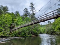
image000000(226).jpg

On this day I stopped early as I found a really nice camping area deep in the forest, enjoyed an early dinner, and read for a few hours. Of course, as the sun was going down I decided it was the perfect time to knock out a few more hours on the trail. This was around 2230 at one of the few gas stations along the route. Just in case you are curious, I only refuel at Top Tier Fuel Stations. Anyway, this professional man rolls up in an immaculate Land Rover and there I am in the same clothes I have been wearing for three days, I had not showered in over a week, etc. Let's just say we stood outside in the cold and talked for nearly two hours. Again, I have met so many interesting people traveling full time and the really cool thing is I cross paths with some of them at different places in the future.
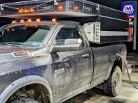
image000000(228).jpg

This is a stream crossing in the middle of the night in the eastern half of the Chattahoochee-Oconee National Forest and provides an accurate representation of how tight and twisty some of the trails were. The folks that laid out the Georgia Traverse did a really fine job since it is a broad mixture of relatively normal forest service roads, water crossings, tighter trails, some pavement, some flat sections, and lots of mountains.
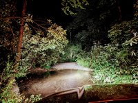
image000000(229).jpg

If you are planning to explore the Georgia Traverse I would suggest you have the ability to air down your tires since many of the trails are rough. It's not mandatory but it will smooth out the ride considerably. Also, I would carry at least one extra fuel tank since stations are generally far apart and usually 20-30 miles off the trail in some areas. When I am in an unfamiliar location off road I generally begin looking for fuel at 1/2 tank while I continue the trail. If I have not come across fuel and I hit 1/4 tank I immediately shift and finding fuel becomes my primary objective. Having additional fuel available is nice but generally is not part of my calculations - that fuel is for an emergency. Another nice feature of this trail is all of the water crossings were around one foot deep and had level rocky bottoms. The water was clear also so it was easy to read the conditions. I still recommend and practice getting out and walking across the ascertain the conditions first hand.
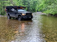
image000000(230).jpg

Sitting on a mountain top near the eastern terminus of the trail with the windows down and listening to some Led Zeppelin. "I ain't tellin' no lie, mine's a tale that can't be told. My freedom I hold dear. How years ago in days of old, when magic filled the air...I guess I keep on rambling, I'm gonna, yeah, yeah, yeah..."
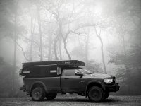
image000000(231).jpg
 
Last edited:

68camaro

Any River...Any Place
Great write up and pictures. When we lived in GA we spent tons of time camping in Suches area and hiking the AT and areas.

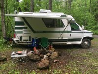
I have a Chinook Concourse RV I use for off-road boonedocking fly fishing trips. It's lifted with AT tires and winch but 21.4 feet long, 10.5" tall including AC and almost 8' wide.

Do you think I would have trouble doing this trail or any parts that would be very problematic?

1694395513857.jpeg
 

86scotty

Cynic
@68camaro, you could do a lot of it but some would be questionable depending on time of year. I did a good bit of the Cohutta loop just last weekend and thought I might have to break out my chainsaw for a few sections in my 4x4 non-high top Ford van but I got through. I also had to lock in 4wd for a couple of eroded hills near the Ocoee River (near Ducktown TN on the map above). The good thing is it is very easy to backtrack and find pavement around any sketchy parts of the Traverse.

@ramblinChet, great pics. You did a great job of capturing all the green that defines the lower Appalachians. As stated above I was just down there last weekend and stayed at Lake Conasauga CG and did most of the loop (the only loop in in your map for those unfamiliar). My favorite area is near Tate City, where I'm guessing your water crossing photo (truck in the river) was taken. The Traverse is not necessarily very technical but probably the best 'overland' route in the SE that I know of.
 

Laps

Active member
Very good trip report and accompanying photos. Because of the increase in gas prices my yearly trip to the West has been postponed until 2024, so I will be doing the Georgia Traverse at the end of October.
 

ramblinChet

Well-known member
I have a Chinook Concourse RV I use for off-road boonedocking fly fishing trips. It's lifted with AT tires and winch but 21.4 feet long, 10.5" tall including AC and almost 8' wide.

Do you think I would have trouble doing this trail or any parts that would be very problematic?

I think you will be fine for 99% of the trail since I completed virtually the entire trail in two-wheel drive. There were just a few short sections that were either tight, required four-wheel drive, etc. but as @86scotty mentioned below, you can always back out, and use a go around. The great thing is that I did not encounter much traffic so you always have plenty of time to park, walk a section, and check your map to identify go arounds, for those few challenging areas.

@ramblinChet, great pics. You did a great job of capturing all the green that defines the lower Appalachians. As stated above I was just down there last weekend and stayed at Lake Conasauga CG and did most of the loop (the only loop in in your map for those unfamiliar). My favorite area is near Tate City, where I'm guessing your water crossing photo (truck in the river) was taken. The Traverse is not necessarily very technical but probably the best 'overland' route in the SE that I know of.

It's a beautiful route and I was really impressed with all of the details that Georgia Overland incorporated. Here is their interactive map which contains a ton of useful information.

In a few months I will be back down south and if I have time available I may squeeze in the 1,200 mile Florida Adventure Trail although I would really prefer to take my time on that ride so maybe next year. I have a few weeks of trails already scheduled with another adventurer in Arizona in mid-November so once again, I am beginning to run short on time!
 

SC4ws

Member
Excellent write-up! As a native of the Southeast, I appreciate your encouragement to not get lost dreaming about the west, but to get out and appreciate the beauty in the wilderness around us. I live close to Jumping Off Rock in SC. The view from there challenges any elsewhere.
 

94-RUNNER

Over The Hill
I have to say that I could not agree more with all that have complemented you and appreciated your travel reports and pictures. I like others am very envious of you. I feel like we are all along travelling with you. Smelling the crisp clean air, getting our feet wet crossing the streams before driving through and enjoying all the unspoiled land that is there to see. Continue to keep us posted on your progress and safe travels !
 

Forum statistics

Threads
188,398
Messages
2,904,152
Members
230,274
Latest member
mbauerus1
Top