welikecamping2
Well-known member
So, there was a recent thread about missed adventures in your region- maybe adventures you planned but never got around to or some that you may get to someday...
Anyway, that got me to thinking about a trail that I've tried to run but have failed twice. I always planned to return, but didn't get to it in time. Red Creek is fed from a variety of springs and minor (very minor) tributaries up in the Pine Mountain Wilderness of Tonto National Forest (Cave Creek District). It is a popular trail for it's challenges as well as riparian beauty. The good news is that the trail is still open, but no longer to Motor Vehicles. In October of 2021, TNF published their final Travel Management Plan. This trail is not on it. As a side note - neither is Cherry Creek Road in the Sierra Ancha's because a part of the historic road goes through a wilderness area. Anyway, I decided to see if it is possible to get down to Red Creek and see what it looks like now.
I left the city early on a weekday morning and traveled to a known starting point. The corner of Cave Creek Road and Bartlett Lake Road once held a huge Microwave tower. Back in the day this was a popular make-out spot for the remoteness and nighttime views of the city. Often it is a meeting place for people recreating in the Verde River basin. I started my track from here, heading north on Cave Creek Road.

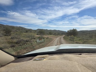
According to OnX, it was 35 miles from this point, so I set my odometer and set off...
At 2.8 miles, you pass Sears-Kay Ruin, an ancient Hohokam hilltop fort.
At 4.5 miles, you hit the end of the pavement, but there will be a couple more patches
At 5.5 miles, you drop into the Camp Creek drainage and there are some cabins that have existed on 99-year leases. It's a cool little spot with about a half mile of pavement. After this you come across the road to Humboldt Mountain L.O. at 9.6 miles.

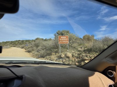
It is a steep, narrow road, and it's been years, but the last time I went up there, the road was paved. The drive is only 5 or so miles and well worth the effort. The Lookout is historic, built by the FAA in 1940, originally a stone building, then upgraded to a steel tower. It sits next to a giant radome that serves regional Air Traffic Control. From the top, immense views of the Verde Valley across to the Mazatzals, north to Bloody Basin, south to the valley and etc. Anyway, a great view. Sometimes, the lookout will let you climb up, but I've never been up this one. At 11.4 miles, you drop into the Seven Springs Recreation area. There is about a mile of asphalt through this canyon.


Anyway, that got me to thinking about a trail that I've tried to run but have failed twice. I always planned to return, but didn't get to it in time. Red Creek is fed from a variety of springs and minor (very minor) tributaries up in the Pine Mountain Wilderness of Tonto National Forest (Cave Creek District). It is a popular trail for it's challenges as well as riparian beauty. The good news is that the trail is still open, but no longer to Motor Vehicles. In October of 2021, TNF published their final Travel Management Plan. This trail is not on it. As a side note - neither is Cherry Creek Road in the Sierra Ancha's because a part of the historic road goes through a wilderness area. Anyway, I decided to see if it is possible to get down to Red Creek and see what it looks like now.
I left the city early on a weekday morning and traveled to a known starting point. The corner of Cave Creek Road and Bartlett Lake Road once held a huge Microwave tower. Back in the day this was a popular make-out spot for the remoteness and nighttime views of the city. Often it is a meeting place for people recreating in the Verde River basin. I started my track from here, heading north on Cave Creek Road.
According to OnX, it was 35 miles from this point, so I set my odometer and set off...
At 2.8 miles, you pass Sears-Kay Ruin, an ancient Hohokam hilltop fort.
At 4.5 miles, you hit the end of the pavement, but there will be a couple more patches
At 5.5 miles, you drop into the Camp Creek drainage and there are some cabins that have existed on 99-year leases. It's a cool little spot with about a half mile of pavement. After this you come across the road to Humboldt Mountain L.O. at 9.6 miles.
It is a steep, narrow road, and it's been years, but the last time I went up there, the road was paved. The drive is only 5 or so miles and well worth the effort. The Lookout is historic, built by the FAA in 1940, originally a stone building, then upgraded to a steel tower. It sits next to a giant radome that serves regional Air Traffic Control. From the top, immense views of the Verde Valley across to the Mazatzals, north to Bloody Basin, south to the valley and etc. Anyway, a great view. Sometimes, the lookout will let you climb up, but I've never been up this one. At 11.4 miles, you drop into the Seven Springs Recreation area. There is about a mile of asphalt through this canyon.