You are using an out of date browser. It may not display this or other websites correctly.
You should upgrade or use an alternative browser.
You should upgrade or use an alternative browser.
Streets and Trips 2009
- Thread starter Go4Lo
- Start date
olympiccop2002
Explorer
I ordered this package:
http://www.amazon.com/Microsoft-Str...5?ie=UTF8&s=electronics&qid=1242923303&sr=8-5
It arrived yesterday so I'll be able to play around with it this weekend. I had streets and trips from 2001 or 2003 so this should be a bit better.")
http://www.amazon.com/Microsoft-Str...5?ie=UTF8&s=electronics&qid=1242923303&sr=8-5
It arrived yesterday so I'll be able to play around with it this weekend. I had streets and trips from 2001 or 2003 so this should be a bit better.
TheAlmightySam
Adventurer
I've been using it. It's pretty clunky - none of the smooth UI polish that Google Earth has, for example, but it is completely functional, and pretty useful.
Some notes:
- The refueling warnings are less than useless. There's no way to tell the system you've refueled at a given point, so it bases its warnings on when you started. After a day or two of refueling when it's convenient, rather than exactly when Streets and Trips tells you to, and the warnings are completely out of sync. Pleh.
- The Nav voice is your default Windows one, so it's absolutely awful and impossible to understand. I just have my girlfriend read me directions instead.
- The software seems to run well on my Mac in VMWare Fusion. I've not extensively tested the GPS receiver, though.
It's useful software, but it lacks a lot of polish, in my opinion.
olympiccop2002
Explorer
I've been using it. It's pretty clunky - none of the smooth UI polish that Google Earth has, for example, but it is completely functional, and pretty useful.
Looks like you have to purchase Google Earth ($400) if you want to use the GPS features. Is that the case or is there a work around to get the GPS to work on the free version?
geoffff
Observer
Looks like you have to purchase Google Earth ($400) if you want to use the GPS features.
How would that work out in the field? Google Earth needs an internet connection for its map (satellite) image data. A cellphone modem isn't going to help you when you're in the outback.
olympiccop2002
Explorer
How would that work out in the field? Google Earth needs an internet connection for its map (satellite) image data. A cellphone modem isn't going to help you when you're in the outback.
I don't know how it would work. I can't afford the $400 to find out... :sombrero:
It says that Google Earth Pro ($400) will do:
GPS data import ** ** verified support for Magellan and Garmin devices only
Real-time GPS tracking
On the website...
http://earth.google.com/enterprise/earth_pro.html#comparison
geoffff
Observer
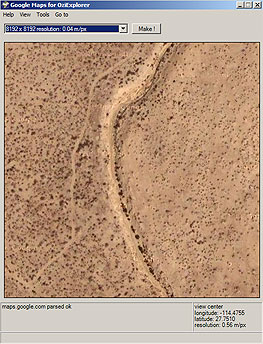
Not to get too far off topic here, but the closest I've come to using Google Satellite image data in field is to download imagery from Google Maps with Google Maps for OziExplorer (http://www.zubak.sk/GoogleOzi/) and then use them with my GPS (with OziExplorer, of course). I've used this for street maps of some Mexican towns, and for satellite imagery of trails. It is such a thrill when out there on a trail to be able to pop up into the sky and see where all those unmapped tracks actually go!
One problem with this approach is having to guess ahead of time where you'll actually be (to download the right data while you're still at home).
But the big issue is that Google doesn't like it! They'll cut you off once you've consumed 100 MB of data -- which is pretty easy to do with the satellite imagery. Oh well...
Oh, and Overland Navigator also sells satellite imagery of the whole world, but (for now) only at fairly low zoom levels http://spatialminds.com/Overland-Navigator-Map-Pack-Satellite-Imagery/M/B001TRINMA.htm It's still helpful for large features like dry lakebeds.
-- Geoff
Last edited:
EricGagne
Adventurer
I use MS S&T 2009 to plan long trips, I like the fact that for each stop you can specify how long you're gonna stay there. Google Maps, GPS Navigation and the likes tell you the driving time of a trip but not the total time.
With S&T you can specify how long you're gonna stop at a point either in minutes or days. For each point you can also specify departure time which makes it easier to plan for trips when you have to meet ferry schedules and things like that.
In about a month I'll be going on a one week trip that will take me from Montreal to James Bay and back via the North Road and I used S&T to plan it.
I also like that it allows you to save it as a web page to share with friends. However if you're gonna publish on a linux web server you're gonna have to edit the html files because by default it uses windows file paths for images and links and puts backslashes instead of slashes in the file paths. (http://ericgagne.info/voyages/BaieJames-20092_files/BaieJames-20092.htm)
That said, I would never rely on S&T for navigation, I never go anywhere without my Garmin GPS and that's the device I use to plot routes and navigate.
Things I don't like in S&T:
1: As previously mentioned, the refuling alerts, there's no way to add a point to your route and say "Refuel Here" so as the route progresses these refueling alertes become totally useless.
2: These alerts about fuel dont' actually use the information in the maps. All it does it put a mark on your route that says "Refuel before here". I think it should have been taken a step further and highlight the gas stations on the last 100 kilometers of that point and allow you to specify where you're gonna take fuel.
3: When your trip will take you between timezones, S&T only tells you on the beginning of the day to check your departure time because the arrival time is in a different time zone but shows that time in the departure time zone. I agree that GPS' don't do it either but at least they don't annoy you with a useless warning.
off-roader
Expedition Leader
Im using streets & trips 09. Came w/ the gps receiver. Not sure if it's any better than the 08 version since I didn't have that version.
I'm a long time GPS user and I find this not as intuitive as the current crop of GPS's including my older Mio 310 and my TomTom Go 730 & am actually considering just using my 730 through my PC instead of using S&T.
Trip planning is a complicated affair when there's only one leg because I find you can't simply tell it an address then press a 'go there from current location' button. You actually have to enter your current address.:Wow1:
Also, I don't like the birds eye view point of view but that's all you have with this software as far as I can tell.
I should also add that alot of GPS features we take for granted (changing screen colors for night viewing, etc.) aren't there with S&T.
HTH:ylsmoke:
Last edited:
RocTrac
Adventurer
Anyone ever used DeLorme Street Atlas USA? I used to travel for work and used this and it got me everywhere I had to go. I use this and Topo USA.
I am using Street Atlas and am looking for something else. The interface is not driver friendly. I have been looking at the Garmin mobile pc. I have used the garmin stuff (Nuvi etc...) for a while and can usually get around in them pretty quickly. I am hoping that it will continue on with the mobile pc. On the same UMPC (Advent 3500PC) I am running the stuff from horizonnav.com. I am not really happy with it but it does look cool.