D
Deleted member 12023
Guest
THE MOJAVE ROAD
by Nate

The Mojave Road is 140 miles of unforgiving dirt trails loaded with history and some of the most beautiful desolate country you will ever see. The trail ranges from washboard fire roads, washed out rocky hills, knee deep silt beds and whoop sections for miles.
The history states the Mojave Road started off as a trade route by the Mojave Indians and later turned into a wagon trail by pioneers, settlers and military. It was a way for the American pioneers to get to California until the railroads were built, which made for much easier travel. It is now used primarily as a four wheel drive road through the Mojave National Preserve for people who are adventurous enough to complete the 2-3 long days off road.
Fully stocked on food, water, diesel, and beer we were ready to start our adventure! We had our trusty guidebook Mojave Road Guide by Dennis Casebier (purchasing this book is highly recommended if you plan on driving the road- we couldn’t have done it without the book!)

Starting the road from the East in Laughlin, Nevada, we pulled over, checked our GPS coordinates to make sure we were in the right place and let some air out of the tires to smooth out the small stuff. Insert air out picture here We spent the majority of the first day taking it slow through the old wagon roads and taking in the beautiful scenery around us. The desert is an amazing place filled with solitude, peace and a general sense of calmness. Within the first 10 or 15 miles, there was a section of road that had a pretty mean washed out section. Our truck was too wide to take the Jeep line to the left so we had to straddle the 4‘ drop off. I asked Sarah to get out and guide me through to make sure we didn’t tip the truck over or nail the differential cover on rocks. It was a learning lesson in spotting…for both of us. Sarah did not realize that I can’t hear whispering directions from 30’ away over the sound of the diesel. Needless to say, we both now understand the proper hand signals to guide the driver!
The first stop we made was about 20 miles in at Piute Creek. Piute creek was the first natural watering hole that we had seen on the Mojave Road. There are not many along the road, so when a source of water was found, it was used to it’s advantage. In 1867, a Fort was built there by the US Infantry. To get to the fort, you drive along an incredibly rocky section of trail- we really put the truck to the test! So far, so good, only a few complaints from the steering box. Continuing down the desolate road, we passed old cattle ranches, washes, an abandoned school bus and tons of Joshua Trees!

Our guidebook said that there is a spot along the road where a tin can hangs from a Joshua Tree. For good luck, those who drive the road put a penny in the can. We got out of the truck and as Sarah is grabbing a penny for each of us to put in the can (including Brady), I notice that the GoPro we had mounted to the outside of the truck is missing! Crap! I start running down the road where we had just come from to try to find it. It was really far away! Good thing I look out for these things. I’m pretty sure Sarah didn’t notice that the GoPro was missing, or even me for that matter, because when I got back she had a penny in one hand and a the camera in the other taking pictures of this momentous occasion.
About 70 miles in, we camped down an old wash near Marl Springs for our first night. Having made it to our campsite just before it got dark, we immediately started making dinner. It was a beautiful night, but was ridiculously windy which made making dinner a treat

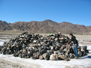
The next morning, we got up, made some coffee and hit the road. There is a mailbox with an American flag about 75 miles in with a book for people who travel the road to sign in. We checked in, took a few pictures and continued on for another 20 miles or so where we got to Soda Lake. There is a monument in the middle of the Lake called Travelers Monument where you pick up a volcanic rock along the Mojave Road and add it to the pile in the middle of the lake. We had our rock and were ready to cross.
Having heard that the lake can be impassible at times, we had called the ranger station before setting out to check on the condition of it. “No way, it’s not passible”. There is a way to go around it, but it takes you off of the Mojave Road, taking away from the feeling of solitude you get when driving this epic road. I am the type of person who has to see it for myself to believe it so I assure Sarah that we can do it despite all of the warnings. Pulling up to the edge of Soda Lake, I get out and check the status of the ground. Dry, and hard as a rock! Sarah is sitting in the passenger seat reading the “extreme caution” section in the book about crossing the lake and is mentally checking into panic mode. As we were about halfway across, you could see the dust getting kicked up behind the tires. No doubt in my mind, we were going to make it! Midway we stopped to place our rock on the monument and continued on towards the Mojave River.
The river is all dried up which makes it possible to bomb down it at a pretty good speed. The faster you go, the smoother the ride! However there were a few deep sand sections which I would not want to get tangled up with by myself. Four wheel drive helped in the hairy sections. Up near Afton Canyon, we found a perfect spot to set up camp. We prepared our dinner while watching the sunset playing shadow games on the walls of the canyon and headed to bed early. The long days of driving can really wear you out.

The last day of our journey we only had about 30 miles left to drive. Once we packed up camp, we drove up and out of the river bed towards the railroad tracks. The Mojave Road runs right along the railroad tracks for about a quarter of a mile before crossing through the river- which actually had water in it! Stoked to plow through the water, I hopped out to make sure we wouldn’t drown the truck in the last few miles of the trip. Once finding out we were good to go, I made Sarah (who is deathly afraid of dark waters) walk through the water to the other side to take a picture of ‘Truck’ swimming

The Mojave Road winds through a final river bed before reaching Camp Cady; the ending point of the trail. There were a few sections of river closed for rehabilitation so we hopped on the BLM roads and headed to the end. Camp Cady was established by US Dragoons in 1860 to protect the road from Indians who were defending their homeland. The protection of the road enabled travelers, merchandise and mail to boost California’s economy. Once peace was achieved, the military withdrew. There is not much left to Camp Cady except for a few rocks which were a part of the corner of the building and a couple of pieces of pipe from an old boiler.
With a feeling of great accomplishment, covered in sand and silt from head to toe, inside and outside the truck and with a dog who had never been so dirty we headed back into civilization. All in all it was an incredible trip, one I highly recommend to anyone traveling through southeast California!
Full write up with gallery here
by Nate

The Mojave Road is 140 miles of unforgiving dirt trails loaded with history and some of the most beautiful desolate country you will ever see. The trail ranges from washboard fire roads, washed out rocky hills, knee deep silt beds and whoop sections for miles.
The history states the Mojave Road started off as a trade route by the Mojave Indians and later turned into a wagon trail by pioneers, settlers and military. It was a way for the American pioneers to get to California until the railroads were built, which made for much easier travel. It is now used primarily as a four wheel drive road through the Mojave National Preserve for people who are adventurous enough to complete the 2-3 long days off road.
Fully stocked on food, water, diesel, and beer we were ready to start our adventure! We had our trusty guidebook Mojave Road Guide by Dennis Casebier (purchasing this book is highly recommended if you plan on driving the road- we couldn’t have done it without the book!)

Starting the road from the East in Laughlin, Nevada, we pulled over, checked our GPS coordinates to make sure we were in the right place and let some air out of the tires to smooth out the small stuff. Insert air out picture here We spent the majority of the first day taking it slow through the old wagon roads and taking in the beautiful scenery around us. The desert is an amazing place filled with solitude, peace and a general sense of calmness. Within the first 10 or 15 miles, there was a section of road that had a pretty mean washed out section. Our truck was too wide to take the Jeep line to the left so we had to straddle the 4‘ drop off. I asked Sarah to get out and guide me through to make sure we didn’t tip the truck over or nail the differential cover on rocks. It was a learning lesson in spotting…for both of us. Sarah did not realize that I can’t hear whispering directions from 30’ away over the sound of the diesel. Needless to say, we both now understand the proper hand signals to guide the driver!
The first stop we made was about 20 miles in at Piute Creek. Piute creek was the first natural watering hole that we had seen on the Mojave Road. There are not many along the road, so when a source of water was found, it was used to it’s advantage. In 1867, a Fort was built there by the US Infantry. To get to the fort, you drive along an incredibly rocky section of trail- we really put the truck to the test! So far, so good, only a few complaints from the steering box. Continuing down the desolate road, we passed old cattle ranches, washes, an abandoned school bus and tons of Joshua Trees!

Our guidebook said that there is a spot along the road where a tin can hangs from a Joshua Tree. For good luck, those who drive the road put a penny in the can. We got out of the truck and as Sarah is grabbing a penny for each of us to put in the can (including Brady), I notice that the GoPro we had mounted to the outside of the truck is missing! Crap! I start running down the road where we had just come from to try to find it. It was really far away! Good thing I look out for these things. I’m pretty sure Sarah didn’t notice that the GoPro was missing, or even me for that matter, because when I got back she had a penny in one hand and a the camera in the other taking pictures of this momentous occasion.
About 70 miles in, we camped down an old wash near Marl Springs for our first night. Having made it to our campsite just before it got dark, we immediately started making dinner. It was a beautiful night, but was ridiculously windy which made making dinner a treat

The next morning, we got up, made some coffee and hit the road. There is a mailbox with an American flag about 75 miles in with a book for people who travel the road to sign in. We checked in, took a few pictures and continued on for another 20 miles or so where we got to Soda Lake. There is a monument in the middle of the Lake called Travelers Monument where you pick up a volcanic rock along the Mojave Road and add it to the pile in the middle of the lake. We had our rock and were ready to cross.
Having heard that the lake can be impassible at times, we had called the ranger station before setting out to check on the condition of it. “No way, it’s not passible”. There is a way to go around it, but it takes you off of the Mojave Road, taking away from the feeling of solitude you get when driving this epic road. I am the type of person who has to see it for myself to believe it so I assure Sarah that we can do it despite all of the warnings. Pulling up to the edge of Soda Lake, I get out and check the status of the ground. Dry, and hard as a rock! Sarah is sitting in the passenger seat reading the “extreme caution” section in the book about crossing the lake and is mentally checking into panic mode. As we were about halfway across, you could see the dust getting kicked up behind the tires. No doubt in my mind, we were going to make it! Midway we stopped to place our rock on the monument and continued on towards the Mojave River.

The river is all dried up which makes it possible to bomb down it at a pretty good speed. The faster you go, the smoother the ride! However there were a few deep sand sections which I would not want to get tangled up with by myself. Four wheel drive helped in the hairy sections. Up near Afton Canyon, we found a perfect spot to set up camp. We prepared our dinner while watching the sunset playing shadow games on the walls of the canyon and headed to bed early. The long days of driving can really wear you out.

The last day of our journey we only had about 30 miles left to drive. Once we packed up camp, we drove up and out of the river bed towards the railroad tracks. The Mojave Road runs right along the railroad tracks for about a quarter of a mile before crossing through the river- which actually had water in it! Stoked to plow through the water, I hopped out to make sure we wouldn’t drown the truck in the last few miles of the trip. Once finding out we were good to go, I made Sarah (who is deathly afraid of dark waters) walk through the water to the other side to take a picture of ‘Truck’ swimming

The Mojave Road winds through a final river bed before reaching Camp Cady; the ending point of the trail. There were a few sections of river closed for rehabilitation so we hopped on the BLM roads and headed to the end. Camp Cady was established by US Dragoons in 1860 to protect the road from Indians who were defending their homeland. The protection of the road enabled travelers, merchandise and mail to boost California’s economy. Once peace was achieved, the military withdrew. There is not much left to Camp Cady except for a few rocks which were a part of the corner of the building and a couple of pieces of pipe from an old boiler.
With a feeling of great accomplishment, covered in sand and silt from head to toe, inside and outside the truck and with a dog who had never been so dirty we headed back into civilization. All in all it was an incredible trip, one I highly recommend to anyone traveling through southeast California!
Full write up with gallery here

