Trip Report – Arkansas and Oklahoma Ouachita Mountains

Bristol

Observer
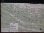
The trip planning thread is here:

http://www.expeditionportal.com/forum/threads/144506-Southwest-Arkansas-Overland-Trip-July-17-19

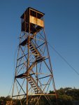
This trip had a little bit of everything you could hope for in an Indiana Jones movie – the saving of innocent life, a crystal mine, secret caves, jumping off of waterfalls, travel over rough land to grand vistas, and finally in the end tragedy and loss. Not bad for a three day weekend!

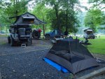
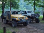
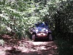
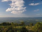
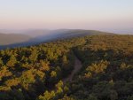
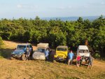
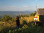
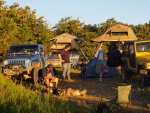
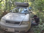
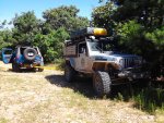
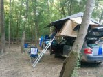
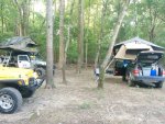
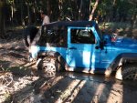
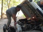
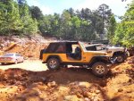
Our group met Thursday 7/18/15 at a neat camping area near Hot Springs, Arkansas. We camped right on the Ouachita River, which was a pleasant setting and surprisingly free of mosquitoes. Rolando in his Jeep Wrangler JK quickly learned to stick to the main path on the way to the camp as an excursion of his led to him burying his rig in mud to the axles. But a tug from the winch on my Jeep LJ soon freed him. Rolando is not on Expo, but I know him through my local Jeep club. At camp we met up with Chris from Expo Portal (thisoneguy) and his son Ian in their Audi Allroad. Later that night Wade (Lilbluerunner) in his Jeep LJ Rubicon showed up from Kansas City and his buddy Matt (DuckTape) and his wife Amy in their 1985 Toyota 4runner made it by late the next morning. So Friday we were off and hit the gravel fire roads near Crystal Springs, Arkansas with the final destination of Clayton, Oklahoma in our sights.

The progress of the group was soon halted though as I stopped to clear a box turtle off of the road. This little guy certainly would have been crushed by one of the huge wheels in this group – thus an innocent life was saved. On up the road and over many hills we came to a sign along with danger warnings pointing us down a side trail to a crystal mine. Off in this remote location was actually a tourist attraction where they were blasting out the side of a hill and for $25 you could dig all day looking for quartz crystals. Our group got an interesting education, but decided to keep our money in our pockets.

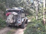
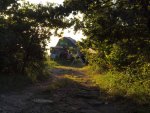
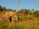
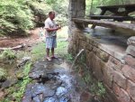
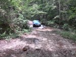
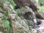
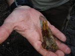
Further on down this remote road we found a nice natural spring and stone picnic pavilion where we took our lunch and chatted with a local. From this local we learned that they went elsewhere to dig for crystals and with our rigs maybe we could just get there. But the crystals the locals found were actually inside caves! So with excellent directions we set out in search of these secret crystal caves. Soon we found the trail and had a great time crawling our way through four creek crossings until we got to the trail. The foot path took us up the side of a cliff that housed many small caves. The caves had been mined heavily, but sure enough there were crystals to be easily had. Our group decided not to work at it too hard, but still were happy with some of our finds.
 

Attachments

  • 20150716_193114.jpg
    20150716_193114.jpg
    293.4 KB · Views: 40
  • 20150716_193144.jpg
    20150716_193144.jpg
    347 KB · Views: 37
  • 20150716_193611.jpg
    20150716_193611.jpg
    222.6 KB · Views: 34
  • 20150717_105248_HDR.jpg
    20150717_105248_HDR.jpg
    236.8 KB · Views: 36
  • 20150717_112839_HDR.jpg
    20150717_112839_HDR.jpg
    226.2 KB · Views: 35
  • 20150717_114754_HDR.jpg
    20150717_114754_HDR.jpg
    435.9 KB · Views: 39
  • 20150717_121232_HDR.jpg
    20150717_121232_HDR.jpg
    236.9 KB · Views: 39
  • 20150717_122708_HDR.jpg
    20150717_122708_HDR.jpg
    258.1 KB · Views: 39
  • 20150717_124006_HDR.jpg
    20150717_124006_HDR.jpg
    220.2 KB · Views: 38
  • 20150717_125708.jpg
    20150717_125708.jpg
    189.3 KB · Views: 42

Bristol

Observer
Back on the main fire road we made some more creek crossings and kicked up a lot more dust before finally converging on the Little Missouri Falls area of Albert Pike. Here we swam and slid down the waterfalls and generally cooled off from the heat of the day.

After the falls we made our way over some passes of the Ouachita Mountains to the Shady Lake Recreation area. Unfortunately the road to the Tall Peak lookout tower was closed, but we still enjoyed camping by this scenic lake and everyone enjoyed the luxury of a nice shower!
 

Attachments

  • 20150717_165513_HDR.jpg
    20150717_165513_HDR.jpg
    480.2 KB · Views: 42
  • P7178124.JPG
    P7178124.JPG
    395.7 KB · Views: 37
  • P7178126.JPG
    P7178126.JPG
    490.4 KB · Views: 34
  • P7188137.JPG
    P7188137.JPG
    358.8 KB · Views: 27
  • P7188145.JPG
    P7188145.JPG
    380.9 KB · Views: 27
  • P7188153.JPG
    P7188153.JPG
    336.8 KB · Views: 27
  • 20150718_172215.jpg
    20150718_172215.jpg
    370.1 KB · Views: 30
  • 20150718_172051_HDR.jpg
    20150718_172051_HDR.jpg
    226.4 KB · Views: 34

Bristol

Observer
Saturday put us back on the gravel fire roads we had traveled the day before and took us to the Wolf Pen Gap ATV area. Now this area though is a public access area and is open to 4WD trucks in addition to the ATVs. A careful study of the map showed some routes we could take that looked passable for our rigs. My research though revealed very, very little discussion of doing these trails in trucks/Jeeps. We ventured forth and found some great challenges for our group, but all quite manageable. We spent a few hours exploring this lovely area, which just left me dumbfounded as to why there was not more discussion about this among the local Jeeple. One challenge was a fallen tree that had been routed around, but the bypass was only wide enough for an ATV. Fortunately Wade formulated an alternative bypass for our group. At another fallen tree we found that my lifted Jeep with RTT just would not fit under it. Again Wade came up with a fix when we dropped my tire pressure to around 10 pounds to give me just enough sag to squeak by the tree. The really miraculous part though was that with all of the challenges we faced we kept seeing that Audi Allroad in our rearview mirrors. With a significant amount of air suspension lift Chris just keep rolling on. This has reinforced in my mind the tenant that it doesn’t matter what kind of rig you have – just get out there and explore as Chris does!
 

Attachments

  • 20150718_103512.jpg
    20150718_103512.jpg
    304.2 KB · Views: 40
  • 20150718_111000.jpg
    20150718_111000.jpg
    432.9 KB · Views: 26
  • 20150718_125327.jpg
    20150718_125327.jpg
    479.3 KB · Views: 25
  • 20150718_125559.jpg
    20150718_125559.jpg
    407.6 KB · Views: 33

Bristol

Observer
From Wolf Pen Gap we headed into Mena, Arkansas for some much needed gas and lunch. From there we dropped down to Hatfield and picked up the far eastern end of the notorious “K-Trail”. We took the K-Trail on into Oklahoma to the fire tower lookout section and made our camp there, enjoying the cooling breezes that our exposed position at the very top of the ridge provided. An enjoyable night with a camp fire, bright stars, and humorous talk ensued.
 

Attachments

  • P7198196.JPG
    P7198196.JPG
    340.3 KB · Views: 24
  • P7188184.JPG
    P7188184.JPG
    336.2 KB · Views: 26
  • P7198198.JPG
    P7198198.JPG
    384.7 KB · Views: 24
  • P7188182.JPG
    P7188182.JPG
    417.7 KB · Views: 25
  • P7188186.JPG
    P7188186.JPG
    403.3 KB · Views: 23
  • P7198207.JPG
    P7198207.JPG
    348.2 KB · Views: 23
  • P7198212.JPG
    P7198212.JPG
    403.2 KB · Views: 23
  • P7198227.JPG
    P7198227.JPG
    370 KB · Views: 23
  • P7198223.JPG
    P7198223.JPG
    364.3 KB · Views: 21

Bristol

Observer
In the morning the Kansas City crowd headed home, choosing to skip the last, and very technical, section of the K-Trail. Matt’s steering box was going south quickly, so it was north that they went. The rest of the crew began a heavily rock strewn trail down the side of the ridge to get us quickly to the western half of the K-Trail. Things were going relatively well until Chris’ Audi suffered a fatal slash that killed one of his tires. Having forgotten his full size spare, Chris had to resort to his donut spare and clearly his weekend was done. While Rolando and I worked to help Chris with his dilemma Rolando’s Jeep JK decided it was done too and developed a mystery electrical issue such that it absolutely refused to start. So back down the trail we crept with the wounded Audi in the lead and me following in my LJ with the JK in tow. Our dreams of finishing the K-Trail and tackling the most technical and difficult section of our trip had come crashing down to a tragic end. But everyone kept their chins up and still marked this one off as an overall success. Chris managed to limp his Audi home to Dallas and after 4 hours of waiting we got Rolando’s rig towed and I drove him home.

Well… in truth it wasn’t quite as exciting as an Indiana Jones movie. But it sure was an excellent way to spend a three day weekend. There were some lessons learned – bring a good spare tire/wheel, bring a good tow strap, bring friends – but most importantly, even if you only have a weekend, even if you only have an AWD Audi, even if you don’t have much experience, at least get out there and explore and see this world and talk to the locals. You never know, you might just find your way to an adventure worth remembering for years to come!
 

Attachments

  • 20150719_090106_HDR.jpg
    20150719_090106_HDR.jpg
    510 KB · Views: 23
  • 20150719_091441.jpg
    20150719_091441.jpg
    324.6 KB · Views: 26
  • 20150719_110623.jpg
    20150719_110623.jpg
    357.9 KB · Views: 23
  • 20150719_162343.jpg
    20150719_162343.jpg
    279 KB · Views: 25

rosco

Observer
Looks like you guys had a lot of fun. I'm looking forward to a week in that area starting this Sat. If you don't mind, could you get me some details of where those cave were? Pm me if you don't want to blast it
 

Bristol

Observer
The mine we visited is Twin Creek Crystal Mine on Collier Springs Road. The springs we visited are Collier Springs further west on Crystal Park Road. The trail to the caves is on the east side of that road about one mile south of Collier Springs. You cross the creek four times and then end up at a very large fire pit. The trail to the caves goes up to the cliff face behind the fire pit. The mine and springs are both clearly marked on Google Maps and Google even has a Street View for the roads, but I couldn't find the exact spot where the trail takes off. Bring digging tools and buckets for water. The easy pickings have been picked. You will need to soak the mud and clay in the caves and dig to find bigger crystals.
 

Bristol

Observer
Chris sent me some photos, which included the first camp on the Ouachita River, which I did not have pictures of. So here they are, to give you a flavor of what that location was like.
 

Attachments

  • IMG_20150717_071759.jpg
    IMG_20150717_071759.jpg
    209.3 KB · Views: 24
  • IMG_20150717_071747.jpg
    IMG_20150717_071747.jpg
    217 KB · Views: 24

thisoneguy

Audi Expositioner
My son and I had a blast, a big thank you to Bristol for putting it all together!

And Bristol, i think you missed the money shoot, an Audi allroad at the top of the k-trail...IMG_20150718_192236~2.jpg
 

rosco

Observer
The mine we visited is Twin Creek Crystal Mine on Collier Springs Road. The springs we visited are Collier Springs further west on Crystal Park Road. The trail to the caves is on the east side of that road about one mile south of Collier Springs. You cross the creek four times and then end up at a very large fire pit. The trail to the caves goes up to the cliff face behind the fire pit. The mine and springs are both clearly marked on Google Maps and Google even has a Street View for the roads, but I couldn't find the exact spot where the trail takes off. Bring digging tools and buckets for water. The easy pickings have been picked. You will need to soak the mud and clay in the caves and dig to find bigger crystals.

So on google maps, I followed Crystal Park Road (CPR) over the creek about 3 times, all the way to Hwy 27. I saw a road cut off to the South when CPR was running E to W that was about a mile away from Collier Springs. It looks like that road leads to a comm tower. Is that close to the trail to the caves or am I way off??
 

Vandy

Adventurer
Man I'm impressed. Looks like a killer trip. Wish I could have jumped on it. Thanks for the pics and the motivation. That Audi must be a beast.

Out of curiosity how did you go about building this route? Local knowledge? I'd love to take a trip like this but unsure how to find these trails.


Glad yall had a good trip. Thanks for the pics!
 

Bristol

Observer
So on google maps, I followed Crystal Park Road (CPR) over the creek about 3 times, all the way to Hwy 27. I saw a road cut off to the South when CPR was running E to W that was about a mile away from Collier Springs. It looks like that road leads to a comm tower. Is that close to the trail to the caves or am I way off??

Nope... the "trail" crosses the creek four times, not the road. The trail is not on Google maps or the USGS maps and you won't see it by satellite as trees cover it. But it is there. One mile south of Collier Springs on Crystal Park Road, which is on Google maps.
 

Bristol

Observer
Out of curiosity how did you go about building this route? Local knowledge? I'd love to take a trip like this but unsure how to find these trails.

This was basically a combination of two sources:

1. The "K-Trail" and "Clayton Trail" are very well indicated on Google maps. All you have to do is trace them out to find where they start and end. That was the western half of the route.
2. There was an article on a dual sport trail that I linked to in the planning thread. This roughly provided the eastern half of the route.
 

Airmapper

Inactive Member
Very cool. I've been sort of investigating this area since some family now lives in Texas and this might be a place I can talk them into meeting me part-way for a camping trip, as opposed to staying in some city. I'm definitely going to be researching this area thoroughly now, looks awesome. Thanks for sharing photos, looks like your group had a blast.
 

rosco

Observer
Nope... the "trail" crosses the creek four times, not the road. The trail is not on Google maps or the USGS maps and you won't see it by satellite as trees cover it. But it is there. One mile south of Collier Springs on Crystal Park Road, which is on Google maps.

I'm tracking. I was just looking for something on the google maps so while exploring that area looking for the trail, I had some kind of landmark that says we've gone too far.
 

Forum statistics

Threads
189,811
Messages
2,921,170
Members
232,931
Latest member
Northandfree
Top