UCE3 - Utah Cruiser Expedition 3

Box Rocket

Well-known member
It wasn't long after we crossed the washout that the sun was down and it got dark quick. Almost like the weather had planned it with the darkness, once the sun went down the rains picked up again. It was never a total downpour but enough to keep the already saturated ground wet and sticky. Low areas that were soft became a challenge.
.
The trail had started to wind through some switchbacks with exposures and the wet sloppy trail made it sketchy as it was difficult to keep the trucks going in a straight line.
.
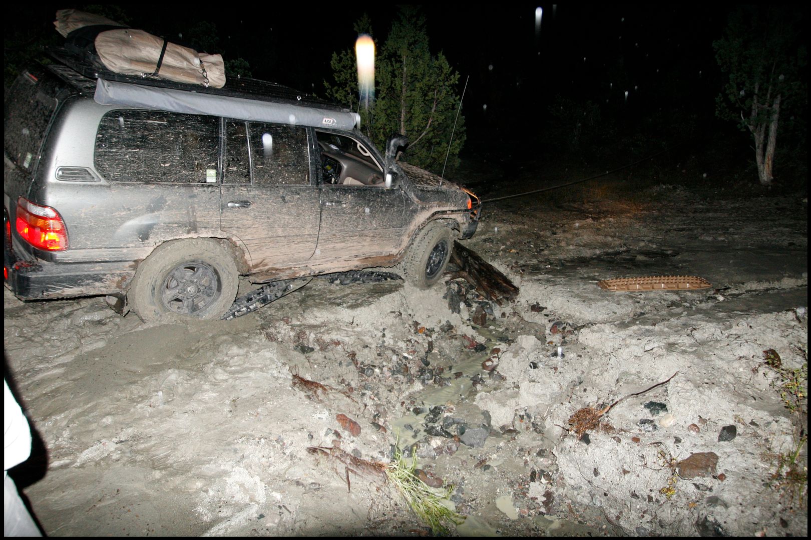
Over the radio we got the call for shovels and Maxxtrax. Kurt had come to another washout and the trail on either side was sloppy clay. We needed to somehow fill the section that had washed out. It became apparent that the line we needed to take was the high lefthand line as the righthand side got deeper and farther to cross and was also off-camber. I apologize for not a lot of photos through this section since it was dark and raining.
.
Everyone that was out helping to move rocks, place maxxtrax etc was covered in mud as it was really getting sloppy. We found some logs that we placed in the ditch and Kurt tried to inch his way across. But as his tires got close to the edge the bank started to give way risking a sideways flop into the ditch.

.
We found a stump up the hill and hooked up the winch, partly as a safety line and also to help drag the heavy cruiser through the slippery muck.

.
Soon the front tires were across but the trail was still breaking down. Rather than make it a worse situation for the rest of the trucks we did a little more road building before Kurt made it all the way across.

.

.
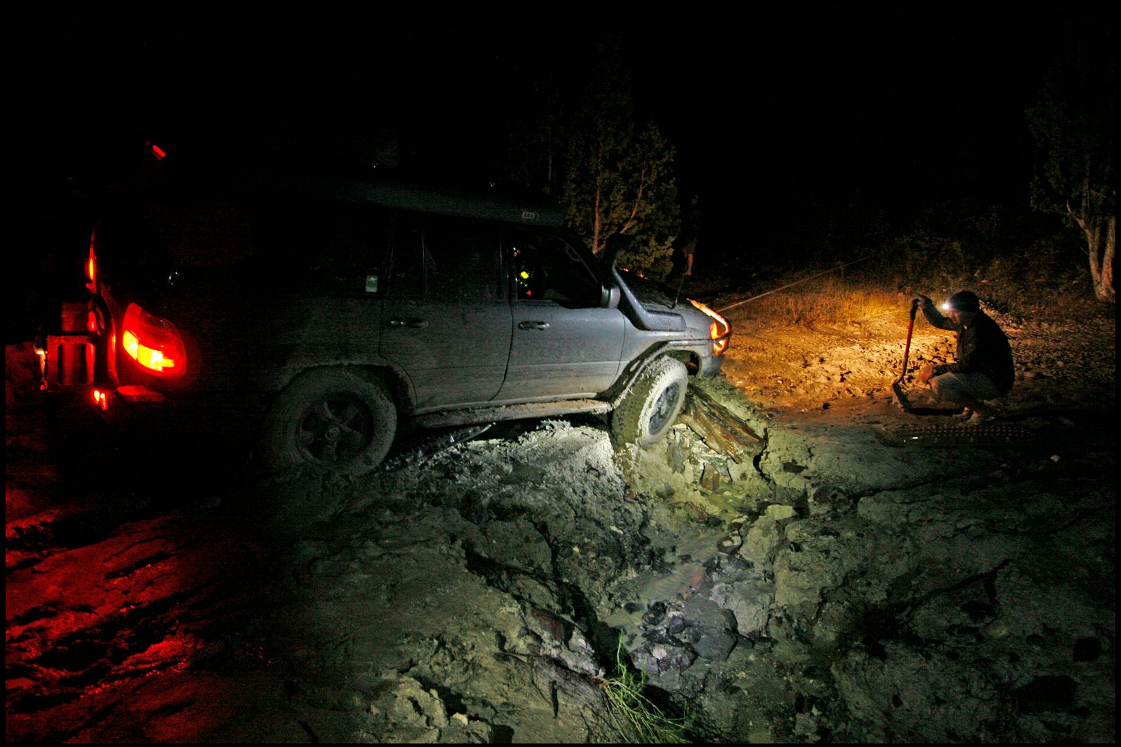
It worked and Kurt successfully winched across. The trail made a right turn just after the ditch so winching from the trail would pull trucks into the deep part of the ditch rather than across. Kurt positioned his truck about 50' up the trail pointing back at the ditch and we ran a snatch block over the the stump that Kurt had winched from. This game us a straight line pull across the ditch for the other trucks. We had used all of our recovery equipment in the spot. Shovels, straps, winch, maxxtrax, lockers and a decent amount of roadbuilding. While the snatch block was set up we found a couple more large logs to place in the ditch. This helped stabilize the crossing and give a better route. Cody and Dan and Ja and Troy both made it across with some extra help from the winch. As each truck crossed it churned the mud on either side of the ditch making it extra soupy. Paul May was the most challenged here with his BFG ATs. He couldn't quite enough traction and he was also winched across.

.

.
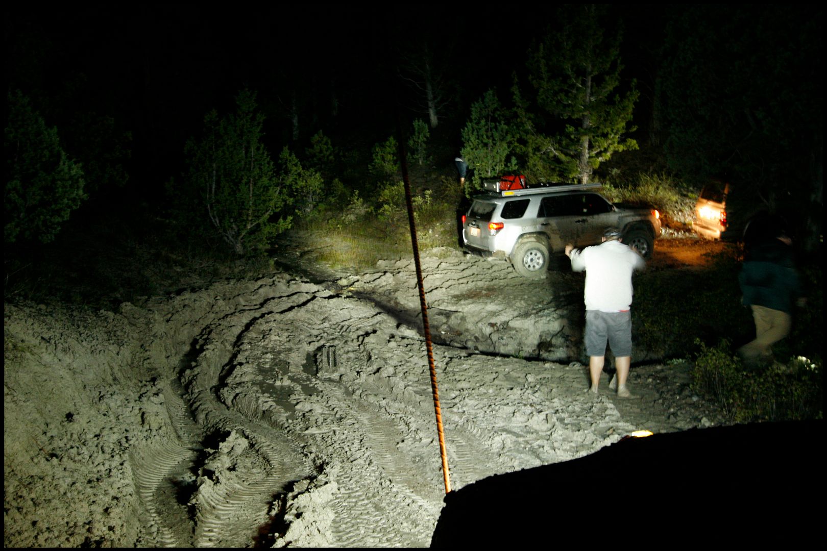
Then it was my turn. As I looked at it I figured I could make it across without the winch. I wasn't worried about taking a winchline but we were hours behind schedule again. It was almost 11pm and raining. I just wanted to get us through as quickly as possible. I was able to keep a decent (although somewhat sideways) line through the muddy approach and then hit the gas. The front went across and as the rear came across I could feel it slide sideways and the passenger rear tire dropped into the deeper part of the ditch. Don't ask me how but I got lucky and with a good amount of throttle I clawed my way across unassisted. Dave Connors was the only truck left and he was able to do the same.
.
Then the search started for the 6 Maxtrax that were buried somewhere in the muck.
 

Box Rocket

Well-known member
We had gathered all our gear and the rain continued to fall.

.
That wasn't the end of it. Less than 1/4 mile later we rounded a hill with a steep exposure and everyone stopped. We got out to take a look and Kurt's Cruiser had gotten a little sideways on the narrow trail around the hill. His rear tire was just a few inches from the very soft, muddy edge of the trail with a steep slope dropping a good 100' down into the bottom of the canyon.
.

.
J put a strap onto the rear of Kurt's truck to keep the rear end from sliding further down the hill. This was the spot that sold me on Maxxtrax. We used the Maxxtrax again here and they worked beautifully to provide enough traction for all the trucks to squeeze past the narrow section where Kurt had slid. Now I'm saving some money to buy myself a set of Maxxtrax. They are a recovery item that likely won't get used that often. But on this night, we would have been in a far worse predicament without them. This rare occasion where we needed them they paid for themselves.
.
There were a few more sketchy sections and finally we were out of the canyon around midnight. We were still a good hour or more from Powell Point where we were supposed to camp......the night before. We cut our losses and took the road out to Panguitch to get gas and clean up. The only gas station that was open must have known we were coming and had a water hose outside. We used the hose to clean mud from the Maxxtrax and all of our shoes and legs and other tools.
.
We were near Byce and the beautiful Bryce canyon national park now even though there was no way to see it in the darkness. Someone in the group new of a campground near the park and we bee-lined to the campground to try to get some much needed rest.
 

Box Rocket

Well-known member
The next morning we debated a warm breakfast at a local diner but instead settled for granola bars, coke and redbull in an effort to make up for more than an entire day of lost time. We headed out for Powell Point finally!
.
Powell Point is breathtaking with an almost 360* view from the point. The drive up was just as enjoyable as the tight trail passed through pines and aspen that had started changing to the fall colors. The trail had many large puddles and waterholes on the way up. So more splashing around and getting muddy as if we hadn't had enough of that yet.
.
Maybe as a subtle reminder of how the light of a new day had brought us renewed energy from the darkness of the night before, an aspen gave us a message.

.

.

.

.

.
There is a small parking area near the point and a foottrail that leads the final 3/4 mile out to the point. We parked and started the short hike passing more pines and deadfall with several trees showing signs of lighting strikes.

.

.

.
The view opened up as we neared the point and all of us were snapping pictures of the awesome view.

.

.

.

.

.

.

.

.

.

.

.
Of course we needed the obligatory group shot here on the point.

.
followed by posting to social media since we had rare cell coverage.

.

.

.
Back at the parking area we snacked a bit and chatted about the day and took a few more photos

.
It pays to be prepared

.
Then it was time to go again. Another leader change, this time Ja and Troy would take the lead and take us over the Aquarius Plateau and Boulder Mountain, the highest forested plateau in the world. This would be one of my favorite sections of the trip.
 

Box Rocket

Well-known member
As we dropped down out of Powell Point we had a nice stretch of forested road that treated us to some quickly changing fall colors

.

.
Boulder Mountain and the Aquarius Plateau is one of my favorite places in Utah. The fact that it's a plateau allows for some outstanding views with large meadows and lots of pine and aspen forests. The colors this time of year are breathtaking.

.
Then we were stopped by a small obstacle. A tree had fallen across the road and needed to be removed before we could keep moving.

.

.

.

.

.
With the tree out of the way we got moving again and the road improved so we could increase our speed and make up some time. The eastern rim of the plateau is the edge of Capital Reef National Park which also adds to the beauty.
.
As we neared the top of the climb to the plateau the road opened up into a nice meadow and the visibly storm clouds gave us a brief warning that more rain was coming

.

.
 

Box Rocket

Well-known member
Boulder mountain is covered with small lakes and it's a haven for fishermen and hunters. I shot my first deer down here on Boulder Mountain when I was 15 years old. Lots of good memories of this area.

.
We stopped for some lunch discussed our route again which would take us on a couple of roads that none of us had ever been on. The ARB and Eezi-Awn Awnings on Paul and Kurt's trucks made a nice shelter from the light rain while we ate.

.

.

.
The rain started to fall harder which told us it was time to load up and get moving again. No sooner had we started down the road that the rains really started giving us the business. This took an already wet trail and turned it into dozens of small lakes that we needed to cross. We were still trying to make good time so at the speed we were travelling it was like a constant series of wave after wave of water covering the windshield.

.

.
After about an hour we got a small break in the rain. It kept falling but not nearly as hard.

.

.
We all began to realize why this place was called Boulder Mountain. The entire landscape was covered with boulders of all sizes and the road was littered with the rocks as well. This made for some slow going and pretty soon we found ourselves on road 117 better known as Chokecherry Point trail. This trail was clearly not used very often as the track was barely visible in some areas where it crossed the meadows. When the trail went into the trees it was some legitimate rock crawling which was a real change from most of the terrain we had covered up to this point. This was slow low range crawling for at least a couple hours. As we looked at our maps the topo lines indicated that the road we were on would essentially drop off the edge of a cliff. We wouldn't see for the trees but pressed on. Then sure enough we came to a series of rock strewn switchbacks that dropped dramatically off the top of the plateau.
.
It's difficult to get a sense of the slope in the photos but it was VERY steep going down with steep wooded slopes on either side.

.

.
It remained steep but the switchbacks stopped and the trail continued to drop through the trees.

.

.
It took us a good hour to make the descent down Chokecherry Point off the top of the plateau and then we hit the highway just north of Boulder Utah.

.
Several of us were low on fuel so we drove the dozen or so miles down the highway toward Boulder for gas and to stretch our legs. Once we had filled our tanks we entered the Grand Staircase of the Escalante National Park. This is a controversial area that was part of an illegal land grab by the Clinton administration. Without following proper protocol for National Park designation Bill Clinton made an executive order to designate the are as a national monument. An area that had been used for over a hundred years by farmers and ranchers was suddenly closed off to them forcing them to move their herds elsewhere. Many of those ranchers went bankrupt and lost their livelihood. The area is also one rich with oil shale and a proverbial gold mine of natural resources. Liberal environmentalists desperately wanted the area closed down to eliminate any possibility of drilling for oil or mining oil shale in the future. This pressure and lots of money from environmentalist groups motivated President Clinton to make it one of the nations newest National Parks. Nevertheless, the Grand Staircase of the Escalante is an area of incredible beauty there is no doubt about it. Without getting to political it is very reasonable for parts of this area to remain protected and still be able to take advantage of the vast amounts of natural resources with almost no trace. But the political process was thrown aside and the area snatched up.
.
In becoming a national park, it also meant that miles and miles of once public access dirt roads were either permanently closed or paved. I personally feel that the pavement of many of the roads (specifically sections of the Burr Trail) show a much great impact from humans than the condition of the area prior to being made a NP or from any impact from the gathering of natural resources. But that's one guy's opinion.

.

.

.
We found a beautiful campsite for the night and made some final changes to our route. The original plan took us into the La Sal Mountains east of Moab near to the Colorado border, but instead we would take the rest of the Burr trail out to Hanksville south of the San Rafael Swell and north of Lake Powell. Hanksville would be our official end of the trip and the group would likely split up and head home via the highways back to the Salt Lake City area. But we still had one more awesome night in some beautiful country.

.
 
Last edited:

Box Rocket

Well-known member
The next morning brought ample sunshine which was a welcome change and began with several more miles of pavement on the Burr Trail before it finally returned to dirt. There are some dramatic changes in elevation in the Grand Staircase area that presented us with some really cool switchbacks and wide open flatlands.

.

.

.

.
Days of rain made for some very wet and soft sections of the trail. There were mud holes and washouts everywhere. Some of the washouts had tall banks that required some careful driving to cross. Dave Connors got unlucky on one particular washout as he was climbing out of it and the soft soil gave way and his cruiser sank to the frame.

.

.

.
A tug from the strap was all that was needed to free his cruiser and we were moving again over more miles of some of the best Utah has to offer.

.

.
By lunchtime we were in Hanksville and refuelling for the drive home. We said our goodbyes to each other as we each had different routes planned for the drive home. My boys had never been to Goblin Valley which is a wild place with thousands and thousands of wacky shaped sandstone formations formed over thousands of years of errosion. It is a popular tourist stop but worth the effort to see it. We hopped on the highway that would be intersected by a fun trail that cut across the desert to Goblin Valley.
.
As my boys and I came to the trail intersection we found Dave Connors and Will Carroll stopped there and they flagged us down. They had a Japanese couple with them who were on vacation. They had planned to see Goblin Valley and the GPS in their rental VW Jetta had taken them down the desert trail. They only got a mile or so down the road and realized it clearly was not where they wanted to be. They had tried to turn around but got stuck in the soft wet sand. They had no cell coverage and were a bit panicked. They had walked back out to the highway and were looking for help when Dave and Will came by. They stopped to help them and that's when we pulled up. They climbed into Dave's cruiser and we set off to find their car. It really wasn't in a bad place but it was definitely too much for the Jetta to handle. We hooked up a strap and pulled them out and got them turned back around to head out to the highway. Even though they hardly spoke english, I could tell they were very grateful to have the help.

.

.

.
 

Box Rocket

Well-known member
Dave and Will followed them back to the highway and made sure they were safe and then headed toward Salt Lake City. My boys and I continued on the dirt trail across the desert toward Goblin Valley. Goblin Valley was pretty busy that day but it is a vast maze of rock formations so even if there is a lot of people there you can still feel completely alone.

.

.

.
We found a couple caves to explore and chased each other around in the maze for a while discussing how it would be an ideal place for a paintball battle.

.

.
Then we were back on the road and pavement toward I-70 and back to Salt Lake City and home.
.
It was an amazing trip. Having participated in a few of these trips with this group of guys we've been able to see places that many will never see in their lifetime. We've learned to overcome challenges as we've encountered countless obstacles on the hundreds of miles of trails we've driven. Having my sons with me on this trip was a real highlight and hopefully a memory that they'll have for a long time. All I do know is that it won't be the last time we have an experience like this. For me, it is worth whatever sacrifice is necessary to create these kinds of memories with my kids and hopefully teach them some life lessons in situations that are more than sitting at the kitchen table giving them a lecture.
.
It's these experiences that motivate me to work to keep public lands open not only to hiking and biking but to motorized travel. It just wouldn't be possible to experience the same challenges and see the variety of terrain and landscapes on a hike or while on a bike. I think that if those of us who enjoy exploring in our 4WD vehicles are careful and use the lands responsibly we can enjoy the sport and the memories and lessons it provides for years to come.
.
Off my soapbox. Hope you enjoyed the report. UCE3 is now complete.
 

Ryanmb21

Expedition Leader
Post of the year. Thanks for sharing the great photos and report. I want to see these areas!
 

jeremyk

Adventurer
Epic and inspiring! Great story, this kind of write up is the reason I came to this web site in the first place.
 

roverrocks

Expedition Leader
Awesome adventure with great pictures though there was way too much tearing up of quagmired roads and trails for my taste or discretion.
 

Howski

Well-known member
Awesome adventure with great pictures though there was way too much tearing up of quagmired roads and trails for my taste or discretion.
So what's the alternative, go off the designated trail and create a new bypass? That's a worse choice IMO. It doesn't appear they were driving back and forth through the mud tearing it up like a bunch of rednecks, so what's the issue?

Great photos and report. Enjoyed seeing a longer trip with some tough obstacles that challenged the vehicles and equipment.
 

Box Rocket

Well-known member
Awesome adventure with great pictures though there was way too much tearing up of quagmired roads and trails for my taste or discretion.


yeah I'm not sure what you suggest we should have done. We did not have alternative routes we could have taken. We weren't "tearing" anything up. In truth the areas that were the most muddy were sections of road that were covered in flood plane flow, or were roads that had been severely washed out by flooding. Any damage done was already there as a result of flooding. Also the rains continued and I can guarantee that there was no sign we had even passed through those places after two days. If those roads which are all on BLM land have any kind of maintenance done to them to repair the flood damage, anything we might have "torn up" would be removed.

I'd be curious as to what you would have done in our situation? This type of trip requires months of planning. That planning couldn't not foresee the effects of the harsh weather that affected the tracks we had planned. Had the roads been dry, obviously there would have been no issue, but do you just abandon months of preparations because the weather changed? I can assure you we all did our utmost to adhere to Tread Lightly principles.
 
Last edited:

pmatusov

AK6PM
Adam - great post, and photos! Now I want to go back to Aquarius Plateau...
It also reminded me of two couples stuck for 24 hours on Cottonwood Canyon road after a spring rainstorm in a VW camper before we just happened (by mistake) on this road and pulled them out... Clay is treacherous.
 

Forum statistics

Threads
188,740
Messages
2,909,735
Members
231,030
Latest member
dterrell
Top