useful iPhone apps -- post your favs

Mad Matt

Adventurer
Has anyone used this for a computer trackpad? Wondering how effective it is.

I know multiple people who use it in conjunction with their big ***** LCD TVs. Seems to work really well.
 

greg mgm

Explorer
I know multiple people who use it in conjunction with their big ***** LCD TVs. Seems to work really well.

Good info...thanks. I'll give it a try and report back.

Next question...How are you guys securing your iphones in your cars?
I used to have a cool cup holder for my old Dell DJ mp3 player..worked great. Doesn't fit the iphone though. I'd like to have it secured for ipod access, maps, etc.

EDIT- I just ordered this cup holder Iphone mount from Amazon....hopefully it'll work out.

http://www.amazon.com/Macally-Adjustable-Portable-Devices-Vehicle/dp/B002JTWRN8/ref=sr_1_1?ie=UTF8&s=electronics&qid=1257293746&sr=8-1
 
Last edited:

AKRover

Adventurer
Yesterday I bought a 32Gb 3Gs Iphone.....man.....now I see what all the fuss is about! A very cool device! Anyway I downloaded Topo maps to my computer, then it installed to the iphone....easy as can be.

Could we please delete this thread? I'm going to go broke buying applications and accessories for my phone!!!!!! :)

Has anyone used this for a computer trackpad? Wondering how effective it is.

I found this trackpad app-

http://www.mobileairmouse.com/
What he was talking about was downloading the maps to the computer and then syncing them with the phone instead of downloading straight to the phone and draining the battery.
 

matt s

Explorer
Wow, that topo app looks pretty nice. I have a different one called TopoPoint and it's not that great. I might have to get that other one.

I just downloaded Morse-it so I could play with code a little bit. Maybe someday I'll learn it. My wife isn't too impressed though, she is rather annoyed by all the beeping. lol

Yeah I have topopoint too. Waste of money. The topo maps one is great. I have all of the valley, anchorage and turnagain arm downloaded so far. The maps are literally scans of the topos. The program stitches them together as well so you get one big map you can scroll and zoom around on. Like google earth but with a topo and it's all on the drive, not internet based.
 

Root Moose

Expedition Leader
The topo maps one is great. I have all of the valley, anchorage and turnagain arm downloaded so far. The maps are literally scans of the topos. The program stitches them together as well so you get one big map you can scroll and zoom around on. Like google earth but with a topo and it's all on the drive, not internet based.

The other thing I like about it is that it seems to do a good job of smoothing the images when zooming in and out so it always looks good/legible.
 

Lost Canadian

Expedition Leader
Been playing with Layar's augmented reality app. It's pretty cool, and when you start digging into it you'll be amazed at how many little web based things you'll find all around you.
 

haven

Expedition Leader
Here's another one: ShopSavvy by Big In Japan

This free app allows you to scan the barcode of an item
you are thinking about purchasing. The app then
looks up the price for the item in nearby stores and online.
It has links to Google Maps to show you where competitors'
stores are located.

In addition, you can tell the app to watch prices for
a particular item. When the price goes down, ShopSavvy
will alert you.

ShopSavvy was originally written for the Android environment.
It was released for iPhone recently. A new iPhone version is
expected in a couple of weeks.

Check out the company website here
http://www.biggu.com/
 

TCM

Adventurer, Overland Certified OC0006
Here's a partial list of my recommended apps. Some are expo related some are not.

Things - a great to-do list application
Evernote- the best note taking application for the iPhone
JotNot - Uses the camera for scanner like functionality
Sketches - Allows you to draw on images with text, arrows, highlights etc.
Flight Update - Track airline flights real time
Gas Cubby - the ultimate gas, mileage and service log
GPS Utility - converts between, DD°, DD° MM', DD MM'SS" and UTM map grids
Sunrise - Sunrise and Sunset Data for any location
Convertbot - Units conversion tool
Shazam - Probably the coolest of all iPhone apps. If you don't know what it is, you will be amazed by what it can do.
Redlaser - Reads bar codes using the built in camera on the iPhone
Remote - Controls the iTunes player on your computer using the iPhone

Of course it goes without saying that the following are good apps and all have web portals as well.

Skype
Google
Google Earth
The Weather Channel
NYTimes
Wall Street Journal
AP Mobile
Wikipedia
Amazon
Ebay
Yelp
Kayak
 

haven

Expedition Leader
Here's a blog post that compares seven turn-by-turn navigation apps for the iPhone.
http://iphone.30minuteslate.com/core-subjects/core-topic-gps-round-up-special

The reviewer does not choose a winner, but the level of detail in the
reviews should help you decide. Categories considered include:
* Price
* Version #
* Size in MB
* Coverage
* Startup Time
* Text-2-Speech
* Multiple Voice Selection
* Sound w/ Music Playback
* Live Traffic
* 2D/3D
* Day/Night Colors
* Speed Limits
* Integrated iPod controls
* Demo Route
* Breadcrumbs
* iPhone OS Keyboard/Visuals
* Keyboard Types
* Autolock Disable
* Speed Camera Alerts
* Lane Assistance
* Realistic Signpost Display
* Navigate to entry in Contacts list
* Detour to POI on route
* POI Display On/Off
* Taps to POI Search Entry
* # of Taps to "Go Home"
* Modes of Travel
* Create/Save Routes
* Directions List
* Add POIs
* Tap Map for POI Info
* Paste from Maps.app

Whew!
 

DavidG

Adventurer
X2 on MotionX. Great app and quite useful when caching pre-trip. Also, Topo Maps for downloaded-to-phone high quality topos.
 

soonenough

Explorer
I love the RadarScope weather radar app. It allows you to view real-time NEXRAD Level 3 radar data from the NWS on your iPhone, and it does it beautifully. It will pinpoint your location on the map using GPS, which is really nice when you're traveling and trying to avoid (or catch) a storm. They put out a recent update that improved the base map and added major highways; it also now prevents the iPhone from 'going to sleep' while the app is running, which is a really nice detail. With just an EDGE connection, it streams the data very quickly. It's not cheap at $9.99, but once you've used it you can't imagine not having it. You can view the following:

Base Reflectivity (4 tilts)
Base Velocity (4 tilts)
Storm Relative Velocity (4 tilts)
Long-Range Reflectivity (248 nmi)
Composite Reflectivity *recently added*
1-hr Surface Rainfall
Storm Total Surface Rainfall
Vertically Integrated Liquid *recently added*
Echo Tops *recently added*

This app is great if you're a weather geek, but if you're used to looking at smoothed & mosaic'd weather radar (i.e. Weather.com, WeatherUnderground, etc), you may not like it. It requires you to know how doppler radar works and understand how to interpret the outputs it gives you (great learning resources for those interested are here, here, and here). For weather geeks, there is truly no other app that compares to this (that I've seen at least); it's the next best thing to having GRLevel3 with you all the time. I actually prefer it over the java-based NWS radar available at Weather.gov. I believe this is the app that Reed Timmer and the TVN team were using in early episodes of Storm Chasers before they had a laptop in their car.

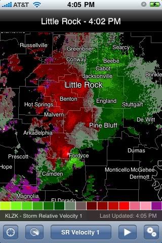
Here's a screenshot of the Storm Relative Velocity (Tilt 1) from my phone while I was watching a recent weather outbreak (10/29/09) across NE Texas, Louisiana, and Arkansas that produced a few tornadoes. In this shot you can see a thunderstorm with a huge mesocyclone crossing directly over Fordyce, AR (evidenced by the large red-green velocity couplet radially aligned to the radar). About 20 minutes before this screenshot was taken, the storm produced an EF-2 tornado in eastern Camden that damaged a fire station there (read about it here and here). If you look closely, you can also see a second smaller area of rotation just north of Camden, as well as a third one directly over Pine Bluff. The app allows you to turn off the city tags so you can see the radar unobstructed, which would've helped in this shot.

RS001.jpg


EDIT: note that this screenshot was taken before the recent update. The town names now have small dots beneath them to clarify exactly where the town is located. Highways are also now shown as faint blue lines and would've been visible in that shot (they can also be turned off if desired).
 
Last edited:

haven

Expedition Leader
Here's another list of free iPhone applications that perform useful functions
http://gizmodo.com/5423680/free-iphone-apps/

In addition to the usual suspects (Google Earth, Photoshop, Skype) here's a free e-reader, a couple of internet radio apps, a barcode scanner to help you shop, a web page copier so you can read it later, when you can't get online, and more.

Did I say these are free?
 

haven

Expedition Leader
iPhone app to track Dakar Rally

VW is offering an iPhone app to help you track the progress of VW's 5 factory-supported teams driving Touaregs in this year's Dakar Rally. The app is free, and can be downloaded here:

www.volkswagen-motorsport.com/dakar_iPhone

The app will link to a 3 minute video summary of each day's racing, plus photos, interviews, maps of the stages, and comments from the teams.
 

Forum statistics

Threads
189,639
Messages
2,919,233
Members
232,632
Latest member
Timboruski
Top