"What handheld GPS devices do that smart phones cannot"

Jason4

New member
I've had very good luck this last winter using a Delorme InReach paired with an iPhone. My fiance spent the month of May climbing Cascade volcanoes and I was able to follow her progress from my desk at work using our shared account. There is a built in screen on the InReach that can show map data, waypoints, and tracks but it's small and low res which is why the device is so nice paired with a smart phone. All of the info displays much nicer on the phone using the Delorme app and it has been fairly user friendly after a short learning curve at the beginning. This system isn't cheap but the advantage is two way communication anywhere that I'll be regardless of cell coverage including an SOS button for emergencies. The battery is rechargeable and is claimed to be good for 100 hours. We haven't pushed 100 hours away from the car in the winter with it but based on what we have done in the summer I don't doubt the claim. The phone lasts that long too since it goes to airplane mode plus bluetooth once we're out of the car.

There are cheaper solutions and better stand alone components but I didn't see anything as simple that gave us redundancy, communication, and most importantly "the button" for help.
 

GR8ADV

Explorer
I am in the middle of that now. Always been a GPS guy but things changed on the last Moto trip doing the AZ and UT bdr's. Montana screen cracked for no reason. One touch it was working next touch not. For those who don't know this not all that uncommon and when t happened the Montana becomes a paper weight.

Running the BDRS without tracks is miserable even in a group. The two others I was with had Motion x on their phones. I downloaded the app and the tracks and boom I was sold. Following tracks in motion x is far better than a GPS as you can see multiple tracks and track options all at once. No cell signal required. Added bonus is that with cell service you can track each other's position ! AND if needed, and it was, you can drop a pin where some is stuck to find them later. It also allowed for a towtuck rescue as we could find the downed rider. None of that is possible with the GPS.

Where the GPS. Shines is custom route planning, re routing without signal and searches. The two platforms are getting very close and I will have to think long and hard before dumping 500 on my next GPS.
 
Last edited:

highdesertranger

Adventurer
ok this is interesting. last year I was on a trip with others, three of them had i-phones. we where well out of cell coverage as I usually am. when we needed a fix my old garmin could get a fix in about a minute. I could turn my garmin on get a fix and turn it back off before they could do anything, I am still searching was all I ever heard. a couple of times after like 5 minutes they finally got a lock, but a lot of times it was way off, I am talking miles. I understand if you have cell coverage they are much faster but outside of that they were worthless. they were like expensive cameras that really don't even take very good pictures. it's like that 10 in 1 tool you see, sure it does 10 different things but doesn't do any of them well. oh yeah there cell coverage was marginal at best I lent my mil spec phone out a lot that trip. btw same carrier on all the phones. highdesertranger
 

GR8ADV

Explorer
For following tracks you do NOT need cell service. With Motion X I download the map and the tracks. I always have them. Cell service is only required to track each other's positions. For this purpose the cell phone actually is a better than a GPS imho. I am doubtful that routing and re routing is available without service but I have not tried. Thus the GPS shines in this regard as well with creating custom maps. For rides that involve following tracks only, the Montana now stays at home.
 

Ziv

Observer
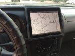
I am a huge Avenza fan. It's free, well designed/coded software that I run on an old original iPad. This is my 3rd season using Avenza. Virtually every National Forest Service MVU map is a geo-coded pdf and can be downloaded from NFS for free. Oregon DOT has geo-coded pdf's for almost every county, also. They are free, as well.

While ‘free' is one of my favorite features of Avenza, I'm attracted to the fact that there is very little technological clutter. Everything you need. Nothing that you don't.

avenza_ipad_xterra.jpg
 

Forum statistics

Threads
186,698
Messages
2,889,077
Members
226,872
Latest member
Supreet.dhaliwal
Top