Creating a Cross Canada Overland Route

deadly99

Explorer
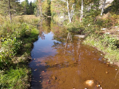
Note: Stephens view of the morning

I woke up after my first night in my hammock rested and ready to hit the trails. I had packed a nice IMP (Individual Meal Packet) of breakfast sausages for myself to enjoy. This isn’t your usual boil in bag. This is genuine Canadian military gourmet cooking. I had sausages, apple sauce, oatmeal, hot chocolate, juice mix, coffee, and a bun with jam all in a neat little package. I did have to warm some of it up but in the end it was a tasty way to start the day and get something warm in my belly.


5009333894_f5b39d695a.jpg


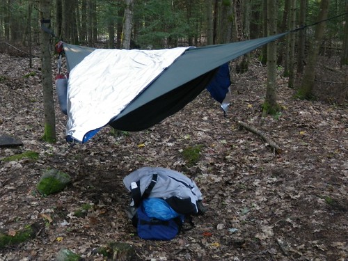
For those who are interested, the hammock worked out great. I had to get up and fiddle with the height of the foot end to make it a bit lower. I also was a bit concerned about my stuff. The only place to keep any of it was on the ground under the hammock. If there was a driving rain it might have gotten wet so I might pack a giant garbage bag for next time and just shove everything in that, then put it under the hammock.

Not 5 minutes down the highway from the campground we were on the trail, and what a trail it was! All snowmobile trails in the winter they were a good run of hilly twisty double track. Nothing too difficult but just enough puddles and interesting terrain features to not get bored.


5008731499_048fc4e8ee.jpg


The trail.


5009353416_6bbe54b938.jpg


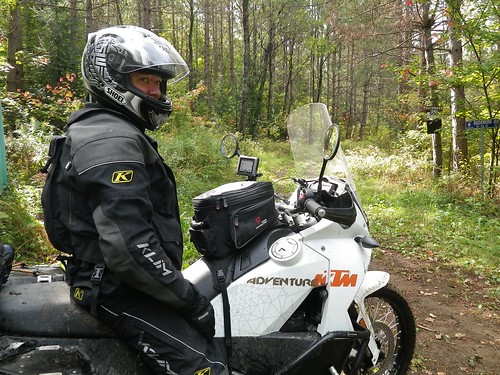
Frank stopped at an intersection.


5008745959_720d97db92.jpg


Chris waiting to find out which direction to go next.

Some of the puddles were bigger than others and needed a certain amount of caution when going through. So far nothing was too difficult and we made decent time on our fully loaded bikes.


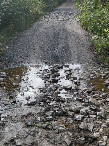
That’s when we came to the big one. WOW. Ted had warned us about the big puddle we were going to have to face but I was confident that it would be no problem because of the “bypass”. Well that bypass is not the easiest option either. A decently steep uphill through the woods to get to a open section of lumpy rocks followed by a steep and twisty downhill back through the woods.


5008734467_d0086a6809.jpg


The big water hole

We checked it out thoroughly and concluded that it might be possible to do we all decided that pushing bikes across the bypass would be easier and quicker than striping a bike and trying to drain it of water.


5008739375_1c60eebe14.jpg


5008736469_5506b15dee.jpg


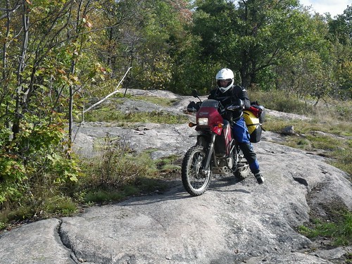
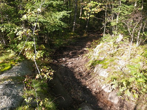
The decent. It’s hard to see but easy enough if you take it slow.

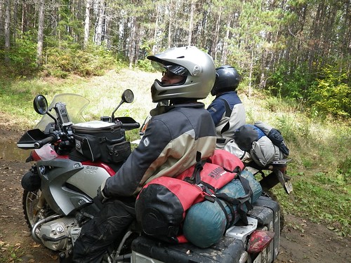
The bigger bikes walked their luggage across and the smaller bikes rode the bypass with no problems. Eventually we were all on the other side, safe and most importantly DRY!

Not for long…


As I was near the back of the pack we came upon the glorious sight of Ted up to his knees in water standing on his bike.


5008740955_480de1176c.jpg


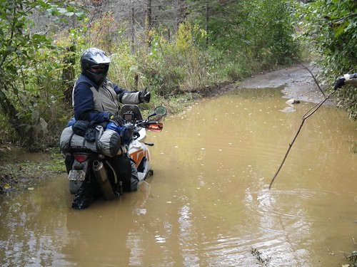
We all parked and proceeded to test the water with sticks to map out what the bottom was like. As it turns out there is a pair of ruts near the left side but the right side is only a foot deep. We would all have no problem getting across but there was still the matter of getting Ted unstuck.


5008743249_6552e149b7.jpg


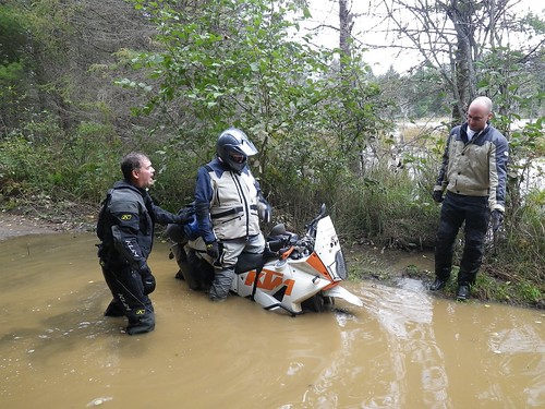
In the end, and with soggy feet, Ted was freed and we all crossed the puddle without any more issues.
 

deadly99

Explorer
TCAT Ontario day Three Cont'd

After finishing this "road", going from memory here but it's about 25 kilometres long and took us about 2 hours I think, we rode some very fun gravel twisties to the town of Kinmount for lunch. Real rollercoaster roads. A few hills with steep drop off's guarantee you will get some airtime Even the big GS left the ground. Have fun (Salmon Lake Road ), if I had my way we would have spent hours riding back and forth on that one road, but we had other promising roads/trails to get to. I'm not a wheelie guy but my front tire certainly didn't get the same mileage as my rear


Kinmount for lunch


2858317_l.JPG


2858318_l.JPG


2858319_l.JPG


After lunch I think we all felt a bit tired. The late night before, the mornings trail and a hot meal certainly gave me the yawns. Just outside of town we jumped on the next trail. Another rail trail, fast and smooth. I really enjoy the just stand on the pegs, twist the throttle, get into a rythm type of riding.


2858320_l.JPG


2858323_l.JPG


About half way down this trail I stopped to look at the signs. ****** atv's allowed but motorcycles are not. Who the feck made that ************** rule? They must have had an issue with 2 strokes at some point in time. ****ty deal for us as this trail connected two spots on the route. We got the maps out and plotted a new route up to the next destination. It looked promising. As it would turn out the roads we assumed were gravel were paved, the gravel ones dissappeared into nothing. Well this wasnt the way this section is supposed to be. There must be other fun trails or old gravel backroads we could be taking. The decision was made to just hit the highway and bomb up to Huntsville before the rain came. I'll have to spend some time with the maps next week and find an alternate method to connect the towns of Kinmount and Huntsville....maybe one of you out there has a suggestion Shoot me an email if you do, thanks.


2858324_l.JPG


2858323_l.JPG


Slabbing


2858325_l.JPG


It started raining just as we were pulling into Hunstville around 5 o'clock. Everyone hit the liquor store to get out of the rain and pick up some supplies. After 5 minutes of everyone playing with their iphones and blackberries, it looked like the weather would clear up in a couple of hours. Frank opted to grab a motel while the rest of us heading to a campground just outside of town.

Setup camp, ate some dinner, had a bevy or two, dried our gear over the fire and put heads to pillows.


2858326_l.JPG


The Nomad Tent's vestibule payed off again. Room inside to standup and change out of my wet gear, hang my gear up to dry, sort stuff out and whatnot. The extra few pounds are well worth it. This isnt the first time this tent has "saved" me from bolting to a motel in inclement weather.


2858328_l.JPG


2858327_l.JPG


2858329_l.JPG


2858330_l.JPG


Another fun day indeed Sleep came easy that night.
 

deadly99

Explorer
TCAT Ontario Day Three Cont'd

http://vimeo.com/15199945

A short vid of a few of the backroads.

NOTE: Pencil Lake Road will be one of the optional technical sections. The main route will travel gravel roads north around this section and offer there own excitement. Some great hills and twists for fun along with some great scenery.
 

deadly99

Explorer
Awesome write up and a great read...Thanks!

No worries, lot's more to come. Canada is a big wide country :)

Leaving Thursday for a fly and drive to BC (4800 km's away). I'll be doing a few select sections of the route on the way back to Ontario (time restraints unfortunately). Looking forward to driving the new to me truck. It's currently at Baja North getting some suspension, tires, lights on the front bumper, mount for spare, etc. Should be a fun rip through the mountains-prairies-forests, etc

Been on the bike for the last few years, having heat and wipers will be a novelty.
 

Christian P.

Expedition Leader
Staff member
This is awesome. Will you be releasing some portion of the road soon or only when you finish the whole thing? Are the waypoints availaible?

Thanks
 

deadly99

Explorer
This is awesome. Will you be releasing some portion of the road soon or only when you finish the whole thing? Are the waypoints availaible?

Thanks


Next fall/winter we will release the routes/info/etc for the eastern half of the country, the western half will be a year behind that. Evrything seems to be on time so I don't, at this point, foresee any delays.
 

deadly99

Explorer
TCAT Ontario Day Four

Day three of this ride had us up and at it early in the morning. Frank showed up looking well rested and ready to go. A quick pack up and we were off to the Timmies down the road for a warm cup of coffee....and a plumbed bathroom

The cool night had created a bit of fog for the morning but the sun was doing it's job of burning it off.


2858331_l.JPG


2858332_l.JPG


The view from the Tim's. Huntsville is a nice town. If I were to take a break for a day or two while doing this route, I think this town would be a good spot for it. Laundrymat, motels, campgrounds, fast food, grocery stores and whatnot are all available. The town itself is a bit touristy, but hey...we're tourists aren't we ?


2858340_l.JPG


The agenda for the day was to get on the Seguin Trail LINK

Ride this trail to where it meets the Nippissing Trail LINK

A side diversion to see the "Field of Screams" and finish this section of the route of in a small city called North Bay. Then slab back to Ottawa. A long day indeed.


We hit the road and got on what we thought was the Seguin Trail


2858342_l.JPG


2858344_l.JPG


This trail ended all of a sudden....hmmm...this can't be right. Maps out, gps hard at work.....ahh...it starts over there....off we go to find "the real trail"

Well the trail was certainly more of an atv trail than an old rail line (too many twists and hills to be a rail line) but it was fin and went for about a half hour, and it was heading in the right general direction.


2858345_l.JPG


The trail ended at a hudro line with no visible exit going forward. We tried heading left on the hydro line, a couple of water crossing later and we ran into a private land sign. We turned around and tried the other direction. What we didn't know.....was that Juames and Frank didnt see us go the other direction down the hydro line, they assumed we had gone back up the atv trail Well the way we went soon ended at another private land sign so we turned around. Where the heck did the rest of the group go? Stuck in the water crossing? nope...hmmm..is there another way out of here, looked around, nope. **** they must be headed back up the atv trail, and probably giving it throttle thinking they are trying to catch up to us.

So we were now two groups instead of one. We tried following tracks down the gravel roads, after a few T intersections we stopped, back tracked, left one of us at each intersection...you know all the tricks. Well they must think we are real asses for not waiting for them We sent them both a text message to meet at the beginning of the next trails section and we were off.

Passed a car in the ditch (must have happened 30 seconds before we showed up). The guy was busted up, VERY obvious that his hand and wrist were not "normal", the kid and wife seemed fine but were in freak out mode. Turns out they loived 5 km's up the road and their family were coming to get them and bring them to the hospital. Yikes, slowed down for a bit after that.

Eventually we found the Seguin Trail. shortly after heading down it we ran into a couple of atv's. They informed us that Juames and Frank were only 15 minutes ahead of us I noticed there quads were dripping wet, they informed us of a water crossing up the trail, "it's 18-24 inches deep with a loose rock base"...... yehaa! I tore off ahead determined to catch up. What a trail, a real beauty. whoops, you either love them or hate them. Well this trail had some real fun sandy whoops and I was tearing it up, feeling like Johnny Cambell But I'm sure I looked nothing like him Froint wheel was bouncing, back wheel skipping over the tops, just a real fun run for me. Made some real good progress, a quick stop at what I assumed was the water crossing, for a picture.


2858346_l.JPG


Turned out to be no big deal, just lean back and twist the throttle, duck the wave and try to stay dry

The trail began to criss cross the paved road it paralels. I jumped on the pavement with the idea of meeting the lads at the meet spot. Well, one more quick section of trail had to be done as I was just having too much fun.

I got to the meet spot and there were Frank and Jimmy 20 minutes later Chris showed up ? Where Stephen? "He says he was going to ride the entire trail in case we missed them or something". Well done Stephen was what I waqs thinking, we'll have a solid gps track of the mornings route A quick look up the trail that we didnt ride.....and....it looked wet, real wet.......


Eventually Stephen showed up (bike looks very clean?).


Frank informed us he had to get going back to Ottawa right away as he had to pick up his passport and meet some friends. A handshake goodbye and he was off. Great riding with you Frank, we'll have to do it again one of these days

We hit the Nippissing Trail/Road and headed north.


2858350_l.JPG


2858351_l.JPG


2858352_l.JPG


The further north we got the more the tree's had changed color.


2858355_l.JPG


The Nippissing Road is a mix of gravel and paved sections, a nice scenic road, nothing tough about it but the scenery was great. It's termed the ghost road. The link above explains it's history. People take there ghosts very serious in this part Lot's of cool histort to check out if your riding this road, take your time, read the historical plaques and whatnot.


2858353_l.JPG


We did a small side diversion, ended up on another short little atv trail....and eventually found the "Field of Screams". It's some retired art teacher, sorry I forget his name, who took up building these ghost creations out of concrete. 2-3 feet thick and up to 30 feet in height. He built ALOT of them. Had to stop for a few pics


2858360_l.JPG


2858359_l.JPG


2858361_l.JPG


2858362_l.JPG


The "artists" house was real weird. Tell you what...when I retire I won't be spending my glory days building weird assed ghost creations, but to each his own I suppose. He also runs a conflicting "cheery" little veggy stand on Sundays beside his house.


2858371_l.JPG


2858372_l.JPG


2858374_l.JPG


Given the time of day and the distance we were from home, it was decided to pack it and begin the slab ride home. Not a bad choice, it had been an excellent 3 days of riding, camping, drinking and whatnot. The route home was on some fun scenic roads. Through a couple of provincial parks (Algonquin, etc). We did a quick stop for lunch on route but other than that we just made miles. Got home just before it got dark, and I for one kicked back in the hot tub with a nice cold beer and a big smile on my face


Jimmy checks the gps one more time


2858363_l.JPG


Lunch stop


2858375_l.JPG


2858376_l.JPG


l in all I was very pleased with the route. A couple of area's need to be refined but as a whole I think this track will make a great addition to the route as a whole. Eastern and Southern Ontario WILL be a highlight of the route. Some folks could probably blast it in two days but my guess is most folks will take 3-5 days. 3-5 days of almost all double track Challenging in parts but "doable" for sure. This entire section will be done via roadbook. I really look forward to reading about others take on this section over the coming years. Anyone interested I'd really appreciate someone doing a beta run on it next summer just to ensure the roadbook works for them. Anyone interested in a few days trail ride in Ontario next summer shoot me a PM.

Well that's all from me for now, time to start planning the two sections left for the eastern half of this route. Northwestern Ontario looks promising with some nice long gravel roads, some fun looking logging roads, maybe a rail trail or two and sadly a couple of long ashpalt sections that seem unavoidable. Quebec had been routed and now just needs to be ridden, depending on the weather this fall I'm hoping to sneek off and complete a chunk of this province. Looks like the majority of Quebec will be gravel back roads with a couple of fun atv style trails just to break it up. Everything is pointing towards us finishing the eastern half by the end of next riding season and then we should have this route up for distribution shortly after.
 

deadly99

Explorer
Franks version of day four of the TCAT, Ontario


Day three started early - I had to make sure I was showered and checked out in time to meet the guys at the campground by 8:00. When I got to the campground, we decided to backtrack into town for some Timmies. We finally got underway a little after 9. The fog was mostly burned off and the day was turning out to be mostly sunny.

Except for the slight diversion up the hydro line and its culvert adorned water crossing that we took in both directions, the riding was relatively fast. It starts with some nice gravel road till we meet up with the Seguin trail. The trail appears to be mostly sand fill on bog. This means that most of the trail consists of what is apparently referred to as "woops" with only a few water crossings. Woops are essentially inverted moguls (depressions instead of mounds). And riding woops is a lot like skiing moguls - well if you were wearing 500lbs skis. It is all about picking the line and letting your legs ride up and down while your head remains steady. In other words, its a lot of fun, but hard work. And the faster you ride, the more work it is. Unless, Ted tells me, you're going fast enough that you just hit the tops and don't even hit every woops. I'll take his word for it.

Since we got separated, Jim and I weren't sure if the others were ahead of us or behind us. We finally decided they must be ahead. We eventually got a text to meet in an hour at Seguin Falls. We rode as fast as I could and I was having a blast. The bike was just eating up the trail. I almost lost it trying to ride the side of the woops at one point but the sand was really sloppy and after saving it I just kept in the bumpy but predictable part ofthe trail. After foregoing two or three bail out points where the trail crosses the road, my legs were burning and I finally begged for mercy. Jim took pity on me and agreed we should take the road to the next RDV.

By then it was 11:30 and I had a 5:00 commitment in Ottawa, so I thanked the boys and headed back.

I learned to ski in a small center in northern Quebec and for the first 10 years I thought that skiing was what we did at Mount Fortin. It wasn't till I got my first job after university and was sent out to Calgary on an installation that I even saw what real skiing was about. This weekend riding with this group I had that same type of epiphany. I discovered that there were more than bunny hills out there. I'm not sure if we were riding blue rectangle or black diamond trails this weekend, but now I know there is a different type of riding to be enjoyed and fully expect to spend more time on this type of riding. I still will take the Harley on nice sedate rides, but I will also be looking for trails to give me that rush of adrenalin.
 

deadly99

Explorer
real time update

Just got back from exploring some of British Columbia, Alberta and Saskatchewan. Great drive, good weather, etc. I'll try to get some pics uploaded in the next few days...as I know the majority of readers on this site drive instead of ride.

Picture 013.jpg
 

deadly99

Explorer
My diesel Jetta finally died I've always been a "truck guy" ,5 years ago I decided I'd buy something a bit more pratical. Bad mistake, driving around in a wee little car that shakes and rattles like only a diesel car can, underpowered and well just not suited to the gravel roads I drive on a daily basis. So I knew I wanted something that could have a fighting chance of keeping up with my bike, could be used as a support vechicle for bike trips, would let me go on bike rides and have Mrs Deadly or one of my buddies who doesnt ride come along, have decent gas mileage, could be used as a daily driver, etc

Alot of web research and I decided on a pre runner style small truck. I got a hold of the guys at Baja North in BC and gave them my list of wants and a price range. Nicier guys you'll never meet. The customer service and the quality of work they do is outstanding

So I flew out to BC with a buddy and picked up the truck last week. I spent a bit of time on the web and chatting with some of the folks involved in the TCAT project and put together a list of roads to ride on the way home as a scouting mission for the route. We got lucky with good weather and some damn fun roads

You'll probably be seeing a bit more of this truck in this ride report. Once the salt gets put down on the roads in Canada the bikes typically get put away for the winter. Hopefully this truck will let me keep working on the route during the off season


2898790_l.jpg
 

deadly99

Explorer
TCAT East Kootenays BC

Followed part of the route threw the east Kootenay's. Great gravel roads threw some fairly remote area's.

Bull River, White River, Kootenay River, Settlers Rd, etc

Cowboy country...real cowboys


2898760_l.jpg


2898762_l.jpg


2898765_l.jpg


Great roads indeed, the scenery is top drawer and other than the occasional logging truck there isn't a whole lot out there. Perfect roads for the TCAT


2898764_l.jpg


2898766_l.jpg


2898775_l.jpg


2898761_l.jpg


The intended route for this section comes through the Crowsnest Pass before grabbing these roads and heading up to Kootenay National Park. It then swings south to the town of Radium Hot Springs. I lived in Radium for a few years and spent alot of time riding back in the Kootenay valley. Although the terrain isn't challenging the feeling of remoteness and the fun gravel roads should offer a fun day to a day and a half of riding. A couple of great camp sites are available as well as some great outdoor natural hotsprings. I don't think this section of the route will disappoint
 

deadly99

Explorer
Chris is plotting the route threw Alberta and Sask. He sent me some gps files prior to me leaving on this trip with some of his intended route selections Thanks Chris I was blown away by the terrain, scenery, etc


COming out of Canmore Alberta is a road called the Spray Lakes Rd. About an hour or more....bet it takes most folks alot more due to the scenery and constant photo op's....

Heading up out of the Bow Valley


2898792_l.jpg


2898770_l.jpg


The road goes up and around this resorvoir before getting into the Spray Lakes Valley.


2898772_l.jpg


2898771_l.jpg


A big wide gravel road greets you at the top. High speed nirvana with some spectacular rocky mountain views. A few nice informal camp spots along the way as well.


2898773_l.jpg


2898777_l.jpg


2898796_l.jpg


2898776_l.jpg


2898778_l.jpg
 

Forum statistics

Threads
185,896
Messages
2,879,549
Members
225,583
Latest member
vertical.dan
Top