Overland Road Planning Thread: (7/21-23/06)

Status
Not open for further replies.

flyingwil

Supporting Sponsor - Sierra Expeditions
flyingwil said:
Interesting... Can I be placed as a tentative on this one? I do have a 'yota!

I will know for sue in mid April once our schedule bid is awarded.


I am game for this one... But if need be give my spot to Seth to get out there and meet some of the ExPo Crew!
(He did say he was game prior to me too!)
 

seth_js

Explorer
flyingwil said:
I am game for this one... But if need be give my spot to Seth to get out there and meet some of the ExPo Crew!
(He did say he was game prior to me too!)

No worries man, I don't want you to miss out. I should probably go on some day trips with you guys before I barge in on something like this.

-Seth
 

flyingwil

Supporting Sponsor - Sierra Expeditions
seth_js said:
No worries man, I don't want you to miss out. I should probably go on some day trips with you guys before I barge in on something like this.

-Seth

Naw dude, take it!

Speaking of... I would love to do a run near where we had AZROCKS... Let me know if you are up for a run someday!
 

seth_js

Explorer
flyingwil said:
Naw dude, take it!

Speaking of... I would love to do a run near where we had AZROCKS... Let me know if you are up for a run someday!

I don't know if you're available tomorrow, but I'm running Sunflower with two friends (great guys). If you haven't run Sunflower, it's an awesome trail. One of my "local" favs. And actually, tomorrow I will be going off the beaten path a little out to the second, less known, better preserved seperator.

If you get this is time and want to come, Beeline and Bush Highway at 7:30am.

Seth
602-740-9954
 

seth_js

Explorer
I assume you have prior arrangements, but you are more than welcome to come if not... any of you for that matter.

-Seth
 

edgear

aventurero, Overland Certified OC0012
Scott -- how is the research coming along for this trip? Are you still going to be doing a write-up for a magazine?
:coffee:
 

seth_js

Explorer
I'd like to join the hike of no one else minds. And I can donate my truck if someone wants to drive it.

-Seth
 

crawler#976

Expedition Leader
Checked out the trail heads today and took a few pic's and GPS coords.

Starting from the southern end of the trail, the first cairn is just across the boundry line between the Prescott Nat. Forest and the Kiabab Nat. Forest on County Rd. 73 at:

N35.0360 W112.2242

The first "official" trailhead, Bandit Trailhead is also on CR 73 at:

N35.0759 W112.2076

The second is at Summit Tank, off FS Rd 57:

N35.1191 W112.1502

The third is off CR 73 and FS 139 at:

N35.1519 W112.1460

Fourth one at Pomeroy Tanks, on FS 109, is at:

N35.1500 W112.0351

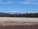
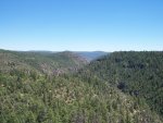
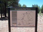
Between Pomeroy Tanks and the next trail head might be some of the most scenic hiking opportunities. The Sycamore Rim Trail and Overland Trail share trail heads, and while it does deviate from the Overland Trail by short distance, might be worth considering. I'm pretty limited hiking wise, but we did get in a short walk to Sycamore Vista from the Sycamore Rim Trailhead off FS 56:

N35.1361 W112.0045

The next trailhead past Pomeroy on the Overland Trail is Dow Springs off FS 131:

N35.1550 W111.9831

The last trail head is on FS 24 before the old trail enters a restricted area on Camp Navajo:

N35.1862 W111.9366

Later!

Mark
 

Attachments

  • horny dude.jpg
    horny dude.jpg
    356.5 KB · Views: 20
  • Catus Flower.JPG
    Catus Flower.JPG
    502.4 KB · Views: 18
  • Sycamore Rim Vista.JPG
    Sycamore Rim Vista.JPG
    450.2 KB · Views: 20
  • Sycamore Rim trail map.JPG
    Sycamore Rim trail map.JPG
    552 KB · Views: 41
Last edited:
Status
Not open for further replies.

Forum statistics

Threads
189,829
Messages
2,921,390
Members
232,931
Latest member
Northandfree
Top