Wind River Ranging

TripLeader

Explorer
Part 11 [Titcomb Basin]

We chose which rocks and boulders to use as our stairs down to the basin floor. Most were steady but some were loose. It was slow going for us. Not true for the same thru-hiker that came up behind us. She showed one of the other traits thru-hikers possessed: speed.
P1330855A.jpg


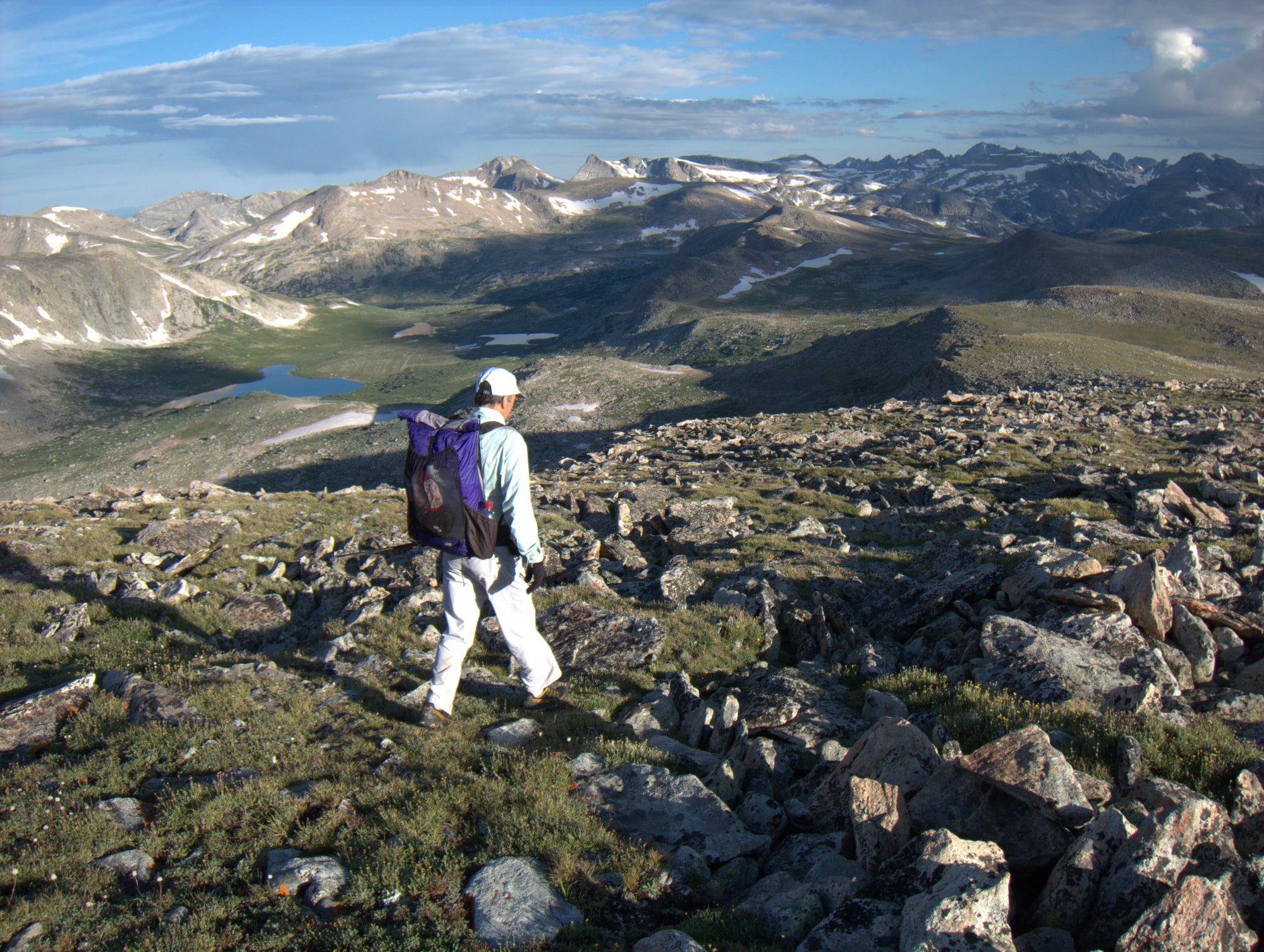
Titcomb Basin was one of the Wind's prizes we had wanted to hold during our research and planning. We were now there with all the jagged and rugged peaks rising around us and the ice below us.
P1330857AX.jpg


P1330862AX.jpg


P1330867AX.jpg


The upper basin held the streams flowing from the snow and ice and rocks. It held drop-offs. There was no trail. It forced us to meander through its obstacles for the right to descend.
P1330880A.jpg


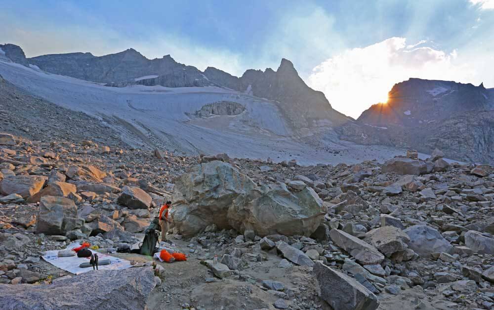
The main basin came into striking distance. But the day was getting long. We found a spot near one of the stacked rock walls was perfect for a dinner stop. From there we would advance down to the lakes to steal another mile or two and find a campsite for the night.
P1330882A.jpg
 
Last edited:

TripLeader

Explorer
Part 12 [Camped at Titcomb Basin]

Moving down toward the lakes.
P1330885AX.jpg


We hiked along the Titcomb Lakes at 10,600'. A trail had developed. The search for a campsite was on.
P1330890A.jpg


Twilight in the basin.
P1330893A.jpg


Breaking camp the next morning, on day three. A tough day was coming. It would not show itself too early.
P1330898A.jpg
 

TripLeader

Explorer
This is the best trip report I've seen on XP for quite some time. Not a single vehicle ! Don't be shy with posting your pictures cause they're awesome ! Definitely the more the better. Thanks for taking the time to share with us.....

Thank you for the kind words. I have been a regular reader of your thread, "My Journey." I recommend it to anyone looking for the best threads on this site.


And to keep the photos coming, here's another viewpoint from Vista Pass post-sunset.
P1330723A.jpg
 

TripLeader

Explorer
Part 14 [To Indian Basin]

P1330938A.jpg


We came up with a strategy to maximize the recovery value of stops on the trail. We ate breakfast at our first break. Breakfasts were mostly oatmeal and coffee cooked up by the JetBoil. Otherwise for gear, I used a Sawyer Squeeze water filter and my two friends used Katadyn BeFree filters.
P1330940AX.jpg


P1330943A.jpg


P1330949A.jpg


Gaining on Fremont & Jackson Peaks.
P1330953A.jpg


Trekking through the high trails in the middle of the Winds meant sensory overload of the best scenery, mile-for-mile, you can hit in the American Rockies. There are other places just as beautiful, and there are other places more wondrous. But they are not condensed into a never-ending mountain tribute like the Winds. If I am wrong, I would love to be corrected and directed to anywhere that can top it.
P1330956A2.jpg


P1330961A.jpg


P1330964A.jpg
 

TripLeader

Explorer
Part 16 [Indian Pass]

P1330984A.jpg


P1330985AX.jpg


I don't know the history of how Indian Basin or Indian Pass were named. I like to think the single thin spire above the pass was the inspiration. I like to think of that spire as a Native who protects his basin. He is always on watch. Taking action when needed, cast in stone when not.
P1330989X.jpg


P1330986A.jpg


We made it to the top of the pass. Along the way up, we had happened upon half a dozen other hikers who had climbed up to take a look. They all turned back and remained on the Indian Basin side. The flipside was going to be a different journey. Much more challenging to our senses; glacier crossing, traillessness, isolation, route-finding. We knew it would be, but we did not understand how it would be.
P1330995X.jpg
 

TripLeader

Explorer
Part 17 [Knife Point Glacier]

The other side of Indian Pass was a new exciting world. All the challenges of the WRHR came at us. The first challenge was to determine the site of the next pass and aim ourselves toward it. The next was to cover the ground between us and that pass. Not as easy as it sounded. The trail had ran out and we were not expecting it to return until we graduated from the next two passes. "Choose your own adventure" was not just the name of a book series we had read as kids.


We donned our micro-spikes onto our boots and crossed all we thought remained of the late summer glacier. We then climbed through car-sized boulders.
P1330998A.jpg


We found an edge too steep to descend. The realization came that the last hour was all a waste. We had not descended far enough before trying to cross the basin. The Knife Point Glacier was still there, just below us under a drop. We had made a wrong-way endeavor. An hour was burned. Another hour would be burned to turn around and get to where we needed to be to launch onto the glacier. The feeling was a low. Could it get lower? Yes.
P1340005A.jpg


High altitude Rocky Mountain adventure had begun. Not class 5 moves. Not giant rappels. Not summiting peaks. It was the culmination of our annual trips to the mountains and the experience gained from them. It was the work toward physical fitness in the months leading up to the trip. It was the planning and research. It was the gear selection. It was the hours of travel and expense to get to the trailhead.


The adventure was the emotional ups and downs of the fight to accept that we were here for reasons. This was the fun. We were in a place that very few could venture to, and very few would ever see. We wanted to be here so badly just earlier. Now we were trying so hard to get out of it and irritated we would have to spend an extra two hours here.


Time had become an enemy. We had been up and working from sunrise to sunset every day. The WRHR had given us 80 miles we needed to cover in six days. The first day had been 15 miles on a trail. The second day had been somewhere around 10, with mostly trails. Now we needed to get over 10 miles per day with no more trails for the next 48 hours plus. This was not a place where you could just make a big next day if you fell short the day before. We had to move and make progress. The mental analysis of where we were and how we could make it to the end was starting.


We re-grouped, put away our frustrations with time, and found a route down to the glacier.
P1340017AX.jpg


Knife Point Glacier was one of the highlights of the trip. None of us had ever been on a glacier before. The micro-spikes made strong purchases into the ice. Moods improved after just a few yards onto it. It was a tremendous experience.
P1340019AX.jpg


P1340021AX.jpg


Streams started materializing as we made our way across. Photos never do it justice, but the size, slope, and drop-off were on a grand scale. The streams became deeper and wider on the far side. The last stream crossing was over a yard wide and over a yard deep.
P1340020X.jpg


P1340022AX.jpg
 
Last edited:

TripLeader

Explorer
Part 18 [Alpine Pass]

Knife Point Glacier came to an end. But then it didn't: the obvious icepack turned to black ice and frozen mud. The glamour and ease of crossing the glacier returned to the hard labor of crossing the rocks again, but this time the rocks were mixed with ice. And it turned uphill.


We were closing in on Alpine Pass. It wasn't easy. In fact, it was hard. And it would have been hard without our 40 pound packs. And it would have been hard if we were better acclimatized. And it would have been hard if we were able to keep up the pace the WRHR demanded. But we still wanted to be here. We knew those challenges coming in.


Looking back at Knife Point Glacier and Indian Pass and the rocky, scrambling route we had taken to approach Alpine Pass.
P1340025A.jpg


We made it to the top of the pass. We knew we would.


One last look back before heading down Alpine Pass toward Alpine Lakes.
P1340026X.jpg


Indian Pass had been a high that turned into a low when we went off course and had to backtrack at the cost of time and energy.


Knife Point Glacier had been a high that turned into a low when it turned to frozen mud and took us to the trek up Alpine Pass.


Alpine Pass had been a low that turned to a high. I was filled with excitement at the top. We had taken the pass and moved from the hardships behind us. I remember being incredibly thrilled with the feeling; thrilled enough to shout. This is what I had wanted--to stand at the top of one pass and look out to see where the next pass would be. This was one of the goals I had for being in the Winds. We had it at the top of Alpine Pass with its commanding view.
P1340030A.jpg
 

Superduty

Adventurer
Amazing trip. You guys are obviously in top physical shape to do such a trip. Curious, if you guys mapped out this "hike" on something like Gaia or all paper maps?

Awesome pictures. Very impressive. Thanks for sharing.
 

ITTOG

Well-known member
Part 2 [The Trailhead]

I don't recall how I first become aware of the existence of this particular range. Perhaps it was a trip to Yellowstone in 2009. Conceivably it was through Colorado mountain research. The idea and mental imagery of Cirque of the Towers did not leave my mind once it found its way in.


Our planning session had initially been to find a loop through Cirque. Any fine route would do, as long as it would keep us from doubling back over a trail we had trodden. We looked over the map, guidebooks, and the internet. We came upon the Wind River High Routes. The first was the Skurka Route. It ran 97 miles through the Winds, including an initiation by summitting Wind River Peak. But it was much too ambitious for us to complete in a week. The alternative was the Adventure Alan Route. It was only 80 miles. And it did not traverse any peaks, just plenty of high passes. Just the right amount of ambition for us.


We were settled. The WRHR was for us. What better way to see everything? We would get to see Titcomb Basin and Cirque of the Towers. Plus plenty of other places that weren't even on the radar. Odd names like Knapsack Col and exciting names like Knife Point Glacier came into our vocabulary.
Is there another name for the Skurka Route? I can't find it on alltrails.


I can fully believe that. It seemed like you couldn't swing a dead cat without hitting some phase of H2O. This was among our last views looking back from Knapsack, with Stroud Glacier on the mountain wall in late August. Bonus points to anyone who can spot the thru-hiker coming up behind us.
View attachment 746313
Found the hiker.


Great report. I imagine you could have included a lot more pictures. These are great.
 

TripLeader

Explorer
Amazing trip. You guys are obviously in top physical shape to do such a trip. Curious, if you guys mapped out this "hike" on something like Gaia or all paper maps?

Awesome pictures. Very impressive. Thanks for sharing.

Thanks.

My partners were in much better shape than me. I was definitely the slow one of the group.

For mapping, I used the pair of Wind River maps from Beartooth Publishing. I found them easy to use. In hindsight, USGS 1:24,000 topo quads would have been better for route-finding than the 1:60,000 Beartooth maps. But the Beartooth maps were easy to fold and carry in a pocket, and "waterproof." I carefully drew in the route on my maps. Adventure Alan has digital maps on his website. I used those for reference to draw my lines with a red Sharpie, which slightly faded and bled by the end of the trip.
20221013_182235.jpg

One of my friends had a GPS app on his phone. I'm not sure which one, but I don't think it was Gaia. He had downloaded a route from some other hikers. We used that as another reference to guide us. But you're never sure how much the other hikers were off route when they made their route, or if conditions had changed on the route.
 
Last edited:

TripLeader

Explorer
Is there another name for the Skurka Route? I can't find it on alltrails.

Found the hiker.

Great report. I imagine you could have included a lot more pictures. These are great.

I don't think I've looked at alltrails in a few years. It would not surprise me if the Skurka route was not on it. I think Skurka sells some of his data on his website.

Adventure Alan is more of an open source on his website, but his is a different route.

That hiker was behind us on some ice in the distance for anyone that is still looking. And she's in another later included photo that looks down into Titcomb Basin. She's on more ice, and about the same distance away. But she's ahead of us in that one!

Thanks for the praise. It's hard to take a bad photo in all that perfect scenery. Overall, I took several hundred photos. I only try to include the best and the ones that help with story telling. I also try not to be too repetitive with photos, but I break that rule occasionally. Here's an extra photo from day one: a water crossing in some very light rain.
P1330704A.jpg
 

TripLeader

Explorer
Part 19 [The End of the Day and the Beginning of a New Way]

The realization came quickly we were not going to make our goal destination for that day. Moving downhill on the rocks was slow-going. Our desired itinerary put us at Golden Lake, something like seven miles beyond. It could have been on the moon and we would not have had any different odds of reaching it. We did not have enough daylight to make it past upper Alpine Lake.
P1340033A.jpg


The route was to take us along the right hand side of upper Alpine Lake. Pushing on into night would be a bad decision and we all knew it. Route-finding in the dark would be difficult. Finding a campsite after sunset would be even more difficult, especially since there was only one possible site we had forecasted within our view of the entire basin.


P1340034AX.jpg


We grasped onto the one campsite option we had. It was at the top left hand side of the lake. Just another thing that would add time and distance to the hike in order to get back over to the right side.
P1340035A.jpg


That evening gave us all an appalling feeling. We could not keep up with the WRHR. We were hitting 9-10 miles per day. We had come in needing at least 12 per day in this stretch, and that was before we were behind schedule. Now we needed 15 miles per day. That was the mental low of the trip. It was night three. So much for our research and planning.


We generated a new plan. We would have to deviate away from the route and get back to some trails on which we could hit 15 daily miles. The only problem was the closest trails were back the way we came. There was no way we were giving up that ground. Plus our vehicle was getting shuttled to the other end of the mountain range. There was no way we could do anything about that. Cell phone coverage did not exist where we were. And one more thing. We wanted to finish, even if that finish did not look like the original plan.
 

TripLeader

Explorer
Part 20 [Class 3]

We broke camp at the upper Alpine Lake at dawn.
P1340037A.jpg


P1340040A.jpg


P1340042A2.jpg


This was a tremendous place to hike. It would also contain the hardest climbing move of the entire trip. There was a rock feature coming up along the lake rated as Class 3, meaning scrambling requiring use of hands, but not to the point of roping up or otherwise being technical.
P1340045A.jpg


This was the place, just around the rock. It took an easy scramble to get there, then a little bit of stretching with one hand and one foot to crawl over. Not difficult or impossible. It just was escalated by the drop off, our packs, and our fatigue.
P1340050A.jpg


P1340055A.jpg


We had been spending all our daylight hours on the move. That had left us with no down time at camp at the end of the day. Things like cold baths had not occurred because of having no time to spare; we had to put mileage goals first. One of my friends hiked out ahead and found a spot to dip. He took advantage of it while he waited for me to catch up.
P1340056AX.jpg
 

Forum statistics

Threads
185,888
Messages
2,879,477
Members
225,497
Latest member
WonaWarrior
Top