15MAR07-24MAR07 4WD/Hiking/Camping in Maze and Needles District of Canyonlands NP, UT

NOTE TO ANYONE INTERESTED: The Dollhouse, Maze Overlook, and Devil's Kitchen can all accomodate multiple groups. If anyone is still interested in coming with, please send a PM or post on this thread. Only the first night would there be two distinctly separate campsites.

Current Tentative Schedule

Part One: The Maze
Thursday 15MAR Drive to Green River or Moab area. 85 on-road miles from Green River to Hans Flat, estimated three hours driving time via HW24 to Robbers Roost Road. Stay at Green River, Moab, or Hans Flat depending on arrival time. Fill tanks at Green River. Depending on time available, take the dirt road from Green River (Airport Road) south to Horseshoe Canyon, hike in to the Grand Gallery, camping options are outside the park as we can only camp in the park after picking up our permit. Plenty of options as this may be an extra day to play.

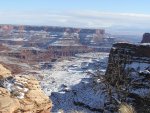
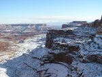
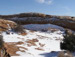
Friday 16MAR Arrive at Hans Flat around 1200. Check in and leave NLT 1400. Drive to Panorama Point, side trip to Cleopatra's Chair. Relax and enjoy the view. Total drive time in the Maze one hour, two hours tops if taking the side trip. Budget 20 offroad miles. Camp PP.

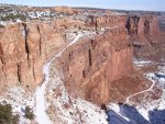
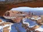
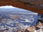
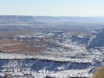
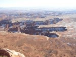
Saturday 17MAR Drive from Panorama Point to the Maze Overlook. This should only be a four hour drive, so we should have plenty of time to hike down to the bottom of the Maze in the afternoon and still be able to relax in camp later. Budget 37 offroad miles. Camp MO.

Sunday 18MAR LONG DRIVING DAY. Break camp early AM, drive to Dollhouse. Potential side trip, hike Golden Stairs--short but steep line from canyon bottom to the mesa we just left. Total drive time approximately seven hours. Budget 39 offroad miles. Camp DH.

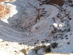
Monday 19MAR Hike the Maze...see Harvest Scene, Chocolate Drops, maybe hike out to Maze Overlook campsite. Return to Dollhouse. Budget 10 offroad miles r/t from Dollhouse to Chimney Rock. Camp DH.

Tuesday 20MAR LONG DRIVING DAY. Hike down to Spanish Bottom, maybe hike up Golden Stairs if we didn't do it on the way in. Drive out through Hite Marina, head east on HW95, refuel in Monticello...we should have plenty of reserve left. Head for Needles Visitor Center--roughly nine hours driving. Budget 54 offroad, 150 onroad. Camp backcountry or frontcountry IVO Needles--Squaw Flat or Indian Creek (BLM). It'll probably be dark or getting there when we pull in to Needles, so an established frontcountry site might be easier and allow more time later.

Part Two: Needles
Wednesday 21MAR Proceed over Elephant Hill to Devil's Kitchen. Once we're here, we can settle for the next three days. Should have plenty of time to hike the Confluence Overlook trail this day and return to camp and relax. Budget 18.1 offroad miles if we go to the overlook and return to Devil's Kitchen the short way.

Thursday 22MAR Hike to Druid Arch in the early AM. Relax. Maybe walk around the area hiking trails. No need to drive.

Friday 23MAR We can continue to hike in Needles, or perhaps drive south and check out the road to Bobby's Hole, or break camp and head to the Lavender/Horse Canyon area & return to Moab on the pavement, or break camp and head up Lockhart and make camp at the river. We will have the campsite in Needles if we choose. 5.9 offroad miles back to the pavement at Needles.

Saturday 24MAR Break camp and head to Moab, from wherever we are. Decide if we'll break off now, or take one more day to mess around.

Sunday 25MAR Head for home if we're not there already, cleaning red dirt off everything.


Old stuff below, leaving it here since it contains details on the BBR route from HW95 to Needles.
Break camp and begin driving to Cathedral Butte via Hite Marina/Natural Bridges/Bears Ear's. Potential fuel at Hite Crossing, Blanding. Six hours/fifty-four miles from Dollhouse to Hite Crossing, 1.5 hours/80 miles Hite Crossing to Blanding. One hour/fifty miles Hite Crossing to Elk Mountain Road. Potential total 134 offroad miles, 165 onroad miles to first fuel stop--budgeting mileage offroad as 1/2x regular mileage, that's 433 potential miles to first fuel stop. Hopefully we will have time to stop at the Natural Bridges visitor center to ask about road conditions over Bear's Ears and from Dugout Reservoir.

Attempt to drive the backcountry route from Elk Mountain Road to Beef Basin Road, over the Bear's Ears (check in at Natural Bridges? if we didn't the previous day). If it is passable, make for either Cathedral Butte or the old uranium prospecting 4WD route to the west (TBDW). 40 miles tops from HW95 to Beef Basin Road--overhead measurement is approximately 30, but that's undoubtedly cutting a few corners. It is almost 30 miles from the Beef Basin/Long Point junction to Devil's Kitchen campground. If Bear's Ears route is impassable, we'll be headed up 211 anyway, possibly take Beef Basin Road from Dugout Reservoir (it is a ~20 mile 2WD road to Cathedral Butte). If both are impassable, take the highway to Needles and enter Elephant Hill from the visitor center. I expect six hours driving from HW95 to Beef Basin Road via Bear's Ears, and 4-6 hours from the intersection of Long Point and Beef Basin roads to Devil's Kitchen. It should be no more than two hours, probably much less, from 211 to Cathedral Butte, depending on road conditions. By the end of the day, we should either be near the Needles visitor center, or south of Needles District on Beef Basin Road. Again, I expect to use all available daylight for travel and camp in the backcountry outside the parks--the payoff in time spent in Needles District will be worth it. Backcountry route is Elk Mountain/Gooseberry/Sweet Alice/Long Point Road/Beef Basin Road. Consensus from BLM and FS staff is BBR is generally impassable until May. More on this later...it is possible to exit the Maze and enter Needles via 95/211 in a day, which would give us an additional day in Needles or the Maze.
 
Last edited:

Rubi-Khan

Observer
I'm game barring any conflicts.

Here are a few pics from Canyonlands from this past January. Enjoy:
 

Attachments

  • Moab 107.jpg
    Moab 107.jpg
    664.7 KB · Views: 48
  • Moab 109.jpg
    Moab 109.jpg
    721.3 KB · Views: 69
  • Moab 110.jpg
    Moab 110.jpg
    681.3 KB · Views: 72
  • Moab 111.jpg
    Moab 111.jpg
    651.7 KB · Views: 36
  • Moab 117.jpg
    Moab 117.jpg
    601.6 KB · Views: 33
  • Moab 122.jpg
    Moab 122.jpg
    671.1 KB · Views: 68
  • Moab 125.jpg
    Moab 125.jpg
    690.9 KB · Views: 33
  • Moab 141.jpg
    Moab 141.jpg
    673.9 KB · Views: 33
  • Moab 143.jpg
    Moab 143.jpg
    692.1 KB · Views: 40
  • Moab 147.jpg
    Moab 147.jpg
    713.9 KB · Views: 38

seth_js

Explorer
I just got back from Moab about 2 hours ago. My first time up there. Freak'n sweet! I went up for wheeling, and was already thinking about heading back up in the spring for some hiking/biking/wheeling.
 

ox4mag

Explorer
JPFreek in Moab

This trip sounds sweet! JPFreek is currently planning a trip up to Moab next Spring so maybe we can coordinate on this. I know that we're definitely game for some good wheeling/biking/hiking/camping out there so as our plans get more defined, I'll keep you posted. Let me know if you'd be interested in coordinating with us on this effort as it sounds like it'll be a blast!

Frank
 
Sure, that sounds like a great idea. My g/f has spring break in March, that may be the only time we could make it for a long trip, unfortunately. If we can't coordinate for a long run, maybe we can join up for a long weekend or two.

...That would be March 17-25, I think. It's a little later in the season than I'd like, but it's the only long stretch we have open. When were you guys thinking of making the run?

Incidentally, Dave is about to do the Beef Basin exit to 211 from Elephant Hill, that's the same route I'd like to take returning to Moab. From Google Earth it looks like there are quite a few hiking trails and/or turnouts along that route.

Most of the route in the Maze is mtb rideable without resorting to a Pugsley, and we have the rigs for the sandy sections. There's only sand--bottomless, soft sand--in one section leading to the Dollhouse, not bikeable but we did it last time in the trucks at street pressure. I think a standard XC width tread, 1.9-2.1, will work fine for biking in the Maze district unless someone knows otherwise. The best rideable portions will be the sections near the Maze Overlook and after Teapot Rock.

Here are a couple ideas I had for exploring in the Maze/Needles districts:

Druid Arch- Approx 10mi R/T hiking, from Devil's Lane in the Needles District. Personally I'd budget eight hours for the hike, that's three hours hiking, two hours relaxing, and three hours back. Does that sound reasonable? I think it can be hiked faster, like two hours each leg. Camping is available at Horsehoof, Bobby Jo and Devil's Kitchen. I've been wanting to see this formation in person for a while.

Chimney Rock Loop (Chocolate Drops/Harvest Scene/Pete's Mesa Route)- This is a day hike, budget a full 10 hour day in case we had to retrace our route back from the far end. I did this hike before with a(n ill-prepared) group but we could not find the exit route to the mesa, and had to backtrack from the far side of the Maze. I'd like to do this route with some people who understand the need for backup plans and water in the desert, so I don't go through 220oz of iced h2o hydrating a group who didn't bring adequate provisions :yikes:. Whether we found the mesa exit or not, it's an incredible route and Harvest Scene is well worth the footwork.

Shot/Water Canyons- Two vehicles necessary, since it's not a loop route, with five miles between entrance and exit. The route goes from Chimney Rock to the Dollhouse and looks like it may be an overnight route, or at least it's a good eight hour hike assuming we stick to the route and don't get lost.

Both sides of Spanish Bottom- Personally I think this would be a cool thing to do, more so than Shot/Water or Chimney Rock Loop. Spanish Bottom can be accessed from both the Dollhouse and from Beef Basin Road (in that area it's actually Devil's Lane) via the Lower Red Lake trail, ten miles R/T hiking. The sat photos show some pretty interesting terrain, think of the geology and topography near the Green/CO Confluence, but we'd get to hike down to the river, once from each side, to Spanish Bottom.

As far as the route in, I've camped before at the Maze Overlook, so I'd be more interested in camping at Cleopatra's Chair or Panorama Point, but what are you guys interested in? The drive to the Dollhouse is about ten miles shorter (~30mi) from the Maze Overlook than from the Chair or Panorama Point, and camping at the Overlook might give us time to hike Golden Stairs (it's short, but steep) somewhere in the mix.

Thoughts?

Also FWIW registration for this area needs to be done pretty far in advance for peak seasons, and March is the beginning of the peak. I'm definately open to other times of year :D.

-Sean

*edit* BTW Seth, I'll be in Phoenix over Thanksgiving, going to meet up with a buddy of mine who will hopefully be joining this trip, if you're interested in meeting up. Dunno how far Scottsdale is from PHX tho.
 

seth_js

Explorer
devinsixtyseven said:
*edit* BTW Seth, I'll be in Phoenix over Thanksgiving, going to meet up with a buddy of mine who will hopefully be joining this trip, if you're interested in meeting up. Dunno how far Scottsdale is from PHX tho.

As of right now, I plan on running El Camino Del Diablo or the Mojave Trail over Thanksgiving weekend. If that falls through, then hell yeah, we can meet up. Or you can come on the run if you want. I'm game for whatever whenever. :p
 
...so I've been looking at a couple other options...

The ~4 day hike between Peekaboo Springs and Cathedral Butte/Beef Basin Road looks fascinating as it's full of culture and history as well as natural beauty and some good, strenuous hiking. The entrance/exit are on or near 4WD access routes, the Salt/Horse Canyon route at the northern end in the Needles District, and BBR at the southern end. There appear to be two southern accesses to the Salt Creek wash, one is the somewhat established hiking trail right off the edge of BBR due west of Cathedral Butte, the other is a very old uranium prospecting road that has probably been unused for decades--officially closed nine years ago, and the northern end looks like the more heavily used section judging by the overgrowth at the south vs lack of overgrowth at the north. For a park & walk, the old road is probably a better place to leave a vehicle as it's more secluded, the BBR/CB hiking trail entrance is right next to the road and a vehicle would be very exposed in the middle of nowhere for four days.

There is apparently usually water in the canyon bottom, so only food would be of major concern assuming hikers carried some means of water purification.

The hike is almost 25 miles from end to end, it can be completed in a single day but that would entirely miss the point of going in the first place. The recommended time is four days.

We might be scouting the area this weekend, from the Grabens/Chesler Park and possibly from the south end along Beef Basin Road. I've been looking at the region via satellite (good ol' Google Earth) for a while now, it looks very similar in structure and beauty to the Maze.

Still looking at a long springtime trip if anyone else is interested.
 
Excellent! What sort of things would interest you most, and what time frame/length would you be looking at? Like I mentioned a few posts back, I only have one good long stretch of time open in the spring, but a lot of these things can be done, albeit a little rushed, in a long (3 or 4 day) weekend.

-Sean
 
wanted to give this a bump.

a couple other discussions and a buddy of mine got me thinking...

i know a lot of the discussion and ownership here centers around trucks and truck-like vehicles, but if anyone with a bike (motor) is interested in this trip, i'm willing to carry some extra fuel and whatnot for a bike. the road to the dollhouse might be a little rough (only the section after teapot, and some sand) for larger, heavier expedition bikes but plenty of people ride dirt bikes back there.

still looking at march, hans flat ranger station entry, needles ranger station exit, or something along those lines. it's snowboard season so i havent been thinking about this much, but wanted to throw the motorcycle thing out there.

also, long/tall vehicles (mogs, pinz, fullsize/length p/u, etc) can easily make it back there...one or two spots with multi-point turns, mostly easy going, beautiful scenery. articulation is more an issue, and only on the elephant hill trail. as far as width, an h1 can make it through the elephant hill squeeze.

-sean
 

2500Adventures

Adventurer
Spring Break Trip...

Saw mention of a possible Spring Break trip out to the Canyonlands and whatnot. I have Spring Break in march as well and am wanting to get back out to Zion since it decided to dump 5 inches of snow on me this past March when I was there and we had to depart. However, I believe my Break is from March 3(saturday)-11(sunday). Not sure who that would work for. But my plans are, as of now to take a Northern route, I-55 to I-70 from Memphis and stay with family and friends along the way to help with the ease of getting out there. As for snow on Red Rock though, boy did I see some whilst out there in March...

here are some snowy pics from Zion on March 9, 2006....
The evening before the snow fell, the clouds were really rolling in..
n56400029_30043670_2996.jpg


Makes for some good poser hiking shots...
n56400029_30043679_6349.jpg


What a morning...
n56400029_30043676_5260.jpg
 
Tentative Schedule

beautiful pics! post up if you're going this way, if you need a place to stay in denver i can put you guys up, and if it's over a weekend a few people might join you in the moab area.

our window is 15MAR07-24MAR07...those are concrete dates, but we're so close to moab that a weekend trip is always feasible.

Tentative Schedule
Thursday 15MAR- Leave Denver in the morning for Hans Flat Ranger Station. Last food/fuel is Green River. Camp at Hans Flat RS or North Point campsite (2.5 miles in from Hans Flat RS). If arrival time is early enough, could camp at Cleopatra's Chair or Panorama Point, 12 miles in to the Maze.

Friday 16MAR- Collect stragglers, anyone arriving later, etc. and continue in to the Maze. If camped at Cleopatra, meet at intersection near North Point campsite in AM. Drive to Doll House campsite--39 miles cross country offroad, easy to medium difficulty. This will be a very long day of driving. Depending on time, potentially hike the short but steep Golden Stairs trail. Depending on time, hike down to Spanish Bottom, or save it for the next day. Skipping the Maze Overlook (26mi r/t) saves quite a bit of driving time and conserves fuel for the remainder of the trip--less driving = more hiking later.

Saturday 17MAR- Hike to Harvest Scene from Chimney Rock via Pete's Mesa Route, or the Chocolate Drops route. Route finding on the loop is very difficult at the back of the loop, near the Maze Overlook. Return to Dollhouse campsite.

Sunday 18MAR- Spanish Bottom or Golden Stairs hikes if not done already. Break camp and head south to HW95/Hite Crossing. 77 miles offroad, potentially camping on the way. Decide if headed to Blanding to refuel or go direct to Beef Basin. If redirect to Blanding, head north on HW211 to Beef Basin road, then 18 miles west to Cathedral Butte and Salt Creek/Angel Arch hiking trail. If headed direct to Beef Basin road, turn as tho headed toward Natural Bridges and take Elk Mountain Road to Gooseberry Road to Sweet Alice Road to Beef Basin Road. East on BBR leads to Cathedral Butte and Salt Creek/Angel Arch trail, west leads toward Bobby's Hole.

I haven't looked at the mileage yet from 95 to BBR, but it's "a ways". I would guess camping near Cathedral Butte either way. There are two entrances to Salt Creek, one is an old 4WD road to the west of Cathedral Butte, the hiking trail is directly north of the Butte.

Monday 19MAR- Hike part of the Salt Creek trail. Personally I would like to see the granary, the old ranch, rock art and such. Unfortunately Angel Arch is about in the middle of the Salt Creek trail. Return to camp and either stay or depending on time, head north toward Bobby's Hole. If the hole is impassable (quicksand, sinkhole or washed out), we must redirect to HW211. Also, vehicles not capable of driving the Elephant Hill trail would probably need to exit to HW211 at this point. The Hill is passable by a more or less stock Tundra, if that helps.

Tuesday 20MAR- Enter the Grabens/Elephant Hill Trail/Needles District. Hiking galore here. Pick a trail...Red Lake or Druid Arch. I lean toward Red Lake, since Druid Arch is apparently better in the AM. Red Lake (12mi r/t) leads to the other side of the Colorado River from Spanish Bottom, where we were a couple days previous. Camp hopefully at Devil's Kitchen, otherwise Bobby Jo or Horsehoof campsites.

Wednesday 21MAR- Hike to Druid Arch (14mi r/t). Camp at the same place as previous night.

Thursday 22MAR- Exit via Elephant Hill, stopping to hike to the confluence along the way. This is a difficult enough trail that getting several vehicles through the route can take all day with inexperienced drivers or barely-capable vehicles. Full skids, sliders, high clearance, large tires, lockers all recommended but not necessarily required. Excellent driving and spotting skills and a cool head absolutely required! We brought a...less than mentally prepared...driver through last time, and it was a nightmare. Stock will not work through this route unless it's well-built, high clearance stock with plenty of articulation, or you're ok with body damage. Ledges, holes, rocks, sharp turns and narrow squeezes in Elephant Hill. It is wide enough for a HMMWV. Better protection means less time to drive over obstacles and more time to hike, photograph and enjoy the views.

Friday 23MAR- ??? Either drive to Peekaboo and hike part of the Salt Creek trail headed south, or head to Moab and run a trail there, or use this as an additional day in the Maze or the Grabens. I'd like to play. Depending on how things are going, this might be an opportunity to follow the easy 4WD routes back in to Colorado. Haven't considered that option yet.

Saturday 24MAR- Food at the Moab Brewery, fill up the growlers, head home. This is the second slop or first emergency day.

Sunday 25MAR- Spend all day cleaning red dirt off everything. Second emergency day.


Trip TBDW: Daily mileage, total mileage between fuel stations, recommended total water, slow pace hiking times, driving time between campsites in order to properly flesh out this schedule.

Needed: Camp toilet
Wanted: Shower, obf (on-board fridge)

Vehicle TBDW: Rear axle/shock hoop+regear front, fridge if time+money allow, deal with tires+clearance, windshield fluid reservoir, finish rear bumper.

Available Space
Looking for at least three, probably no more than six vehicles...not counting motorcycles if anyone wanted to come with. Currently have one other Tundra coming with. Motorcycles perfectly welcome as far as I know, and I have seen them in The Maze before, keep in mind The Maze and Elephant Hill are rated difficult in places and more suitable for dirt-oriented bikes.

Post up if you're certain you'd want a spot, as I am making reservations within the next week, also with what you think of the schedule or if you have prior experience with the route between HW95 and the Grabens via Beef Basin Road and comments regarding Bobby's Hole.

-Sean

*edit* last time, we intended to exit Needles via Lockhart Basin. Hopefully that will be an option this time. More later...
 
Last edited:

upcruiser

Perpetual Transient
Sounds like a great trip. I'm planning my annual trek out there likely in early April. I'm hoping to catch some warmer weather and no snow thus waiting for April. I might be through there in mid March as well on a drive back from Oregon to CO. If the dates end up lining up at all, I'd be game for meeting up. Won't have my rig with me in March, will be drivig the Silverado, but will have my bikes with me so any climbing, hiking, or biking, I'm game for.:)
 
A Silverado, assuming you have decent ground clearance, can make it in and out of the Maze...tho I'd be extremely hesitant to take it over Elephant Hill.

No MTB this trip--not everyone who wants to go has a bike--but if you mean motorcycle, feel free to come with!

-Sean
 
After a long conversation with a ranger...

Unfortunately, this trip needs to be limited to three vehicles and nine people :(

...per group :D.

The Cleopatra's Chair and Panorama Point campsites are very close, there are multiple campsites at the Dollhouse, and several campsites close to Devil's Kitchen.

I don't see any problem with more than three vehicles, in fact I think it'd be a lot of fun...but you'd have to assign your own group leader, etc...and make separate reservations.

The roads may or may not all be passable through Beef Basin during that time of year due to spring snow, or leftovers from winter snowfall in shady areas (there are a couple).

Robber's Roost Road and the rec roads leading down Flint Trail and past Teapot Rock have degraded in the last couple years, in particular during October's 6" of rain--usually rainfall in the area is only 7" PER YEAR.

There is gas probably available at Hite Marina, depending on time of day and electrical connection :p. Not going to count on this! I will assume no gas at Hite and plan for gas either in Moab or Blanding. Still getting numbers together.

I do have geocoords for the turns from Natural Bridges to Beef Basin Road.

Day temps during that season may be as high as 60 degrees F :p. It will probably get below freezing every night...I am going to pack for 0F and hope it never gets below 20F.

If it snows, the road is usually sufficiently dry five hours after snowfall. I don't plan on driving in the dark, at all, unless it's an emergency, and with three JIC days, snow should not be an issue since there are multiple exit points and fuel locations along the planned route.

The driving times listed on the NPS maps are actually long for a well-equipped 4WD...particularly Robber's Roost Road from Hans Flat to HW95 is a great place to make time if you're feeling baja-inclined. However, I'm planning the full time, with an hour extra for unfamiliar or difficult spots, and hoping that it doesn't take that long...if it doesn't, that's more time to relax in camp or take photos on the route. Any vehicle with travel to spare can move pretty quick over those roads, but I have read accounts of stock vehicles getting the crap pounded out of them by people trying to drive too fast.
 

Forum statistics

Threads
189,149
Messages
2,913,870
Members
231,861
Latest member
Herb colvert
Top