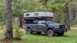
2021 RAM 3500 Tradesman | AEV Prospector | FWC Grandby

ramblinChet

Well-known member
Part 2 of 2

The first half of my Panhandle Adventure Trail adventure can be found here.

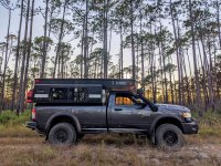
The trails in Florida are quite different compared to those in most other areas since they are mostly sand with occasional mud or clay. Of course, the trees and other plants are very different also and despite this being a very long trail, I was enjoying every single mile in the forest. There were times I would travel for a half-day or more without seeing another person.
PHAT 11.jpg

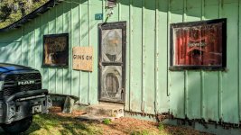
You may not be familiar with the panhandle of Florida but long ago I worked for and represented Tampa Bay Engineering throughout the 11,000 square mile we referred to as LA, or lower Alabama. Here is an example of what we called a "gun and knife club" back in the day. As you may have guessed, this is where young men met to drink and engage in all sorts of manly competition. We called them gun and knife clubs because you were checked at the door to see if you were carrying a weapon. If you were not carrying, you were not permitted to enter, although sometimes they had a house collection of guns of knives you could borrow if you bought a drink for everyone.
PHAT 12.jpg

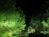
This was pushing into that beautiful hour in the forest as the sun was falling asleep and the moon was beginning to wake. This picture was taken with the factory projection LED low beams on and nothing else. I enjoy travel at night through the forest since it provides a very different type of appearance compared to daytime travel. If you are on a multi-day adventure I would encourage you to engage in some night time travel. Auxiliary lighting is not mandatory but is nice to have in some situations. Since our speeds are normally limited to a maximum of 25 mph or so and our eyes do a great job of adjusting, OEM lights are fine for most situations.
PHAT 13.jpg

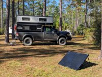
This is the third time in as many years that I have enjoyed camping at Wilderness Landing Park in Blackwater Creek State Forest, Florida. A dozen grassy, flat campsites, flush toilets, warm showers, moderate weather, and free! Finding a gem like this is akin to hitting the lottery. I decided to hang around for three days and two nights to just slow my exploration down and conserve some funds for the long trip to the west. As always, you meet cool people at a campground and there is always some entertainment regarding campground drama.
PHAT 14.jpg

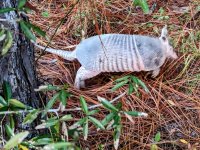
This is what early German settlers in Texas referred to as Panzerschwein, or armored pig. We call them armadillo, or more specifically, nine-banded armadillo. They are edible, I ate one during a survival training on Eglin Air Force Base back in the 1980s. I don't remember is being all that bad but it was not as rubbery as the snake I ate a few days later. Anyway, I was chasing this armadillo and attempting to convince it to jump straight up since they can jump around three or more feet into the air. This one would simply bolt forward and go back to hunting for food. Playing in nature and having fun is what you do when you camp for extended periods without cellular service. Try it, you might like it!
PHAT 15.jpg

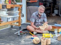
This is another example of some of the cool people you meet camping in the forest. This is Dan, a retired architect, who now spends his time camping, hiking and looking for interesting pieces of wood, and them crafting them into all sorts of interesting usable type of art - in the back of his camper.
PHAT 16.jpg

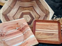
Dan has what most would call a toy-hauler. His toys are different though since he has a wood shop in the back of his rig. He currently runs off two 100 Ah lithium batteries and 480 watts of solar although his goal is to effectively double his energy system. Here are a few more of the pieces he has recently created. From what I gathered, he creates these pieces and gives them away to people he meets. Dan is a really nice guy and I do hope to cross paths with him again.
PHAT 17.jpg

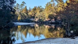
This is not the greatest picture but it is an example of the private beaches you find along the Blackwater River deep in the forest. The sand is white and the water is tea colored. The water is crystal clear but has a tea colored tint due to the tannic acid seeping in from nearby trees. It's not harmful and actually quite refreshing on a warm day since this water is cool and only a foot or two deep in most areas with a sandy bottom.
PHAT 18.jpg

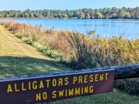
Previously, we covered venomous snakes which are a minor concern. Alligators take concern up to the next level. I have swam in many inland locations in Florida but when there is a sign posted, I will respect it and consider another. A friend called a few weeks ago and shared with me that there were two alligator attacks in a spring in the Ocala National Forest where we cooled off and swam back in February. We both agreed that we will swim there again, but Paul asked me to jump in first.
PHAT 19.jpg

And after a 915-mile adventure through northern Florida with approximately 70% of the travel being on sand, dirt, or gravel, through the forests and swamps I can say I have completed the Panhandle Adventure Trail with twenty-nine hours of drive time spread over seven days. The route is advertised as 500+ plus miles although I do not believe that is entirely accurate. Some of the additional miles were a result of visiting nearby towns for supplies which is normal on longer excursions. Many other miles were racked up when I would come upon a road closure or locked gate sometimes deep in the forest.

Identifying different routes is normal and part of the fun although west of Milton, Florida, was a nightmare. There were multiple locked gates when I believe were public easements running through private land. Since this was in a rural and undeveloped section of the state the rerouting were long and there were two times I came upon another road closure and locked gate during rerouting. My suggestion is unless you wish to explore the entire northern section of Florida, focus on the central section down south including Tate's Hell State Forest and Apalachicola National Forest. Happy trails!
PHAT 20.jpg
 
Last edited:

ramblinChet

Well-known member
Hello again Texas! On my way to spend the winter in the south west I decided to have some fun and combine two trails into one larger one. The first is known as South Cotton Lake Road to SHNF (120 mi) while the other is the infamous Cheeseburger Loop (170 mi). This should have provided me with 290+ miles of fun in east Texas along with some quality time in Sam Houston National Forest. If you suspect things did not go quite as expected, you are correct. I am simply happy I did not end up being shot or thrown in jail. My lesson learned is that I must perform more research before downloading a GPX file and hitting the trail.

The southern half of South Cotton Lake Road to SHNF from Beach City to Cleveland, Texas, was mostly paved roads, contained a few errors, and locked me into an uncomfortable situation. Just north of Cleveland you will immediately jump into the Sam Houston National Forest so I would recommend adding that to the Cheeseburger Loop if you are coming up from Houston.

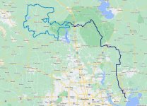
Dark blue is South Cotton Lake Road to SHNF whereas medium blue is Cheeseburger Loop.
CBL 00.jpg

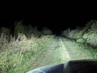
This is northbound on Texaco Road where it breaks off FM686. Of course, I always enjoy traveling at night in unfamiliar places, and to add a bit of excitement, I passed through a gate with a dozen locks and about as many "NO TRESPASSING" and "PRIVATE PROPERTY" signs hanging on it. Most of the property in Texas is privately owned although many of these same properties have public easements or roads which pass through which are perfectly legal to drive on.
CBL 01.jpg

It is possible that either I am wrong or some of the land owners feel differently since occasionally you come across a locked gate which technically is prohibiting use of a public road. I need to perform more research on this subject so I keep myself out of trouble but this evening went from bad to really bad in within thirty minutes. In short, I passed through an unlocked gate, drove two miles north, then drove another two miles to the east and came upon a locked gate. I then decided the best thing to do would be to drive back out and find a go around. Unfortunately, when I returned to the gate that was previously unlocked, it was not locked. It was around 2100 local, I was locked inside an area with mostly grassy roads and the occasional dirt one.

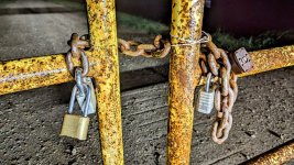
I stopped my vehicle and though about what I was doing and began trying to come up with a plan to get back to a main road. It was confusing that the gate that was unlocked maybe thirty minutes earlier was not locked and I was not sure if someone working had left or if someone was aware that I was on the property and was planning to confront me, or was calling local law enforcement. I was sure this was a public road but then again, I was locked in. Here is an example of a gate that I found on the north end of Texaco Road where it crosses a canal and then turns west. It was unlocked although the map showed this road being a dead end.
CBL 02.jpg

Here are some of the "roads" I began to explore while attempting to escape. I wish I had taken other pictures but I it was getting late and my primary mission was to get back onto a paved public road. While exploring I came upon what appeared to be an abandon grain storage facility (30.10116881152415, -94.96113447759215) that was dilapidated and surrounded with old tractors that themselves were overgrown with weeds. It looked pretty bad since every road I explored ended up with a locked gate or it was impassible.

Fortunately, I happened upon a place where I reclusive man lived - I turned off my bright lights, honked the horn, and when he came out I immediately said I am trying to get back to the main road and all the gates were locked. I felt bad when he said he could see the bright lights roaming that fields and he was scared because he was not sure what was going on. This man was kind and understanding and after I explained my predicament he shared with me a way to sneak out where there was no gate. In the end I drove east across a large field towards a farm and did not feel too comfortable doing what I was doing, but I saw the pavement ahead and got out of Dodge!
CBL 03.jpg

This is the beautiful Shell Road Hunter Camp just north of Cleveland, Texas. A few local trucks circled through early in the morning and then local law enforcement did also but no one gave me any problems. It is a large flat area with enough room for at least a dozen vehicles to park. It felt good to know I was in a National Forest at a legitimate camp. The entire scenario which had me locked in was still confusing and my lesson learned was to try to stick to more commonly explored trails while performing additional research.
CBL 04.jpg

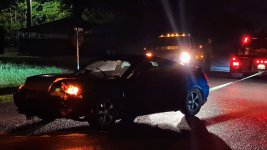
This is an example of me coming upon an accident out in a rural area which took place just as I was driving up. As soon as I realized what happened I slowed down, kicked on my four-ways, and began to slowly approach the scene. As I was pulling up a few other trucks appeared from two other directions and by the time I parked and got out, they were already hooking up a strap and ready to pull the car out of the ditch. The girl was out and walking around and even though air bags were deployed she said she was fine and did not require any medical attention. Within a minute or two the car was pulled out and phone calls were being made. It all happened a bit too fast for my liking but I was not in charge.

A lesson learned long ago it that when something bad happens it is common for folks to set their own safety aside and rush in only to make matters worse. This is why I purposely slow down the process and make many observations before entering an accident scene. A good thing is that I had a winch, full recovery kit, and fire extinguisher available. I failed through since I do not have a basic medical kit on board with me. I must perform some research and pack one in my cab just in case.
CBL 05.jpg

Here is a shot from the eastern section of the Cheeseburger Loop while traveling through the Sam Houston National Forest. This was a really nice area and perfect time of the year.
CBL 06.jpg

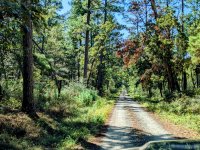
Another well maintained road that was part of the Cheeseburger Loop. I am not sure who at Adventure Riders was responsible for this loop but it is a nice one. If you download the GPX file make sure to select the most currently on that can be found here.
CBL 07.jpg

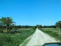
The western half of the loop is mostly farm country - still some beautiful riding. I like how the east half is in the forest with trees while the west half open up to farm country and that big Texas sky. There are also approximately four fuel stops equally spaced around the loop.
CBL 08.jpg

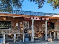
Here is why the trail is named Cheeseburger Loop - it's because of Yankee's Tavern and more specifically, their famous 1/2 pound Wide Glide burger which is "served on our signature jalapeno bun topped with crispy bacon, three different types of cheese, and finished off with grilled jalapenos, mushrooms, and onions. Perfectly paired with an order of our tavern chips." It does not get any better than this men and the sisters behind the bar were collared and dressed to kill. The funny thing is, that is not how they normally dress, it was Halloween and I had no idea. The burger and service were great though and so was the trail.

For me, the entire trip was 305 miles long and took 10.25 hours for an average speed of 30 mph. If you are in the Houston area or just passing through on Interstate 10, head up to Cleveland, jump on the last half of South Cotton Lake Road to SHNF and knock out the Cheeseburger Loop. Do not attempt this at night and make sure to think twice before passing through a gate with locks that is covered with signs.
CBL 09.jpg
 

Pacific Northwest yetti

Expedition Medic
Glad you are enjoying the drive. And thanks for posting.
Always good to keep your head on a swivel. I was surprised when you motioned not having a med kit. You always seem so prepared. I’m sure by the time you are reading this you have remedied that situation. But if you ever want to talk remote medicine and risk management. Give a shout.
 

ITTOG

Well-known member
That is very close to me but I have not gone on those trails. So flat it takes out a lot of the interest for me. I guess the locked gate issue is probably the only time your heart raced a little.

The cheeseburger route used to have a bridge out and I wasn't aware it was repaired. Makes me wonder if it was repaired or if the route changed to avoid it.
 

nickw

Adventurer
Hello again Texas! On my way to spend the winter in the south west I decided to have some fun and combine two trails into one larger one. The first is known as South Cotton Lake Road to SHNF (120 mi) while the other is the infamous Cheeseburger Loop (170 mi). This should have provided me with 290+ miles of fun in east Texas along with some quality time in Sam Houston National Forest. If you suspect things did not go quite as expected, you are correct. I am simply happy I did not end up being shot or thrown in jail. My lesson learned is that I must perform more research before downloading a GPX file and hitting the trail.

The southern half of South Cotton Lake Road to SHNF from Beach City to Cleveland, Texas, was mostly paved roads, contained a few errors, and locked me into an uncomfortable situation. Just north of Cleveland you will immediately jump into the Sam Houston National Forest so I would recommend adding that to the Cheeseburger Loop if you are coming up from Houston.

Dark blue is South Cotton Lake Road to SHNF whereas medium blue is Cheeseburger Loop.
View attachment 804561

This is northbound on Texaco Road where it breaks off FM686. Of course, I always enjoy traveling at night in unfamiliar places, and to add a bit of excitement, I passed through a gate with a dozen locks and about as many "NO TRESPASSING" and "PRIVATE PROPERTY" signs hanging on it. Most of the property in Texas is privately owned although many of these same properties have public easements or roads which pass through which are perfectly legal to drive on.
View attachment 804562

It is possible that either I am wrong or some of the land owners feel differently since occasionally you come across a locked gate which technically is prohibiting use of a public road. I need to perform more research on this subject so I keep myself out of trouble but this evening went from bad to really bad in within thirty minutes. In short, I passed through an unlocked gate, drove two miles north, then drove another two miles to the east and came upon a locked gate. I then decided the best thing to do would be to drive back out and find a go around. Unfortunately, when I returned to the gate that was previously unlocked, it was not locked. It was around 2100 local, I was locked inside an area with mostly grassy roads and the occasional dirt one.

I stopped my vehicle and though about what I was doing and began trying to come up with a plan to get back to a main road. It was confusing that the gate that was unlocked maybe thirty minutes earlier was not locked and I was not sure if someone working had left or if someone was aware that I was on the property and was planning to confront me, or was calling local law enforcement. I was sure this was a public road but then again, I was locked in. Here is an example of a gate that I found on the north end of Texaco Road where it crosses a canal and then turns west. It was unlocked although the map showed this road being a dead end.
View attachment 804563

Here are some of the "roads" I began to explore while attempting to escape. I wish I had taken other pictures but I it was getting late and my primary mission was to get back onto a paved public road. While exploring I came upon what appeared to be an abandon grain storage facility (30.10116881152415, -94.96113447759215) that was dilapidated and surrounded with old tractors that themselves were overgrown with weeds. It looked pretty bad since every road I explored ended up with a locked gate or it was impassible.

Fortunately, I happened upon a place where I reclusive man lived - I turned off my bright lights, honked the horn, and when he came out I immediately said I am trying to get back to the main road and all the gates were locked. I felt bad when he said he could see the bright lights roaming that fields and he was scared because he was not sure what was going on. This man was kind and understanding and after I explained my predicament he shared with me a way to sneak out where there was no gate. In the end I drove east across a large field towards a farm and did not feel too comfortable doing what I was doing, but I saw the pavement ahead and got out of Dodge!
View attachment 804564

This is the beautiful Shell Road Hunter Camp just north of Cleveland, Texas. A few local trucks circled through early in the morning and then local law enforcement did also but no one gave me any problems. It is a large flat area with enough room for at least a dozen vehicles to park. It felt good to know I was in a National Forest at a legitimate camp. The entire scenario which had me locked in was still confusing and my lesson learned was to try to stick to more commonly explored trails while performing additional research.
Great report!

The locked gate situation - been there a handful of times myself....same situation here in Oregon out in the desert that we frequent on our motos. General rule of thumb is if gate is unlocked and no signs, it's an easement. I'd like to think if/when I do end up on private property the landowner would kinda laugh it off and tell me to let others know, no big deal, on your way....but it's high anxiety since you just don't know who you are dealing with.

A couple months back we were way out and ended up in a area with 3 large bulls, had to sneak under a steel gate (quickly), ended up in some farmland which was sketchy and obviously private property and eventually I could see the gravel road so going forward was better than going backwards, thankfully the gate was unlocked but on the other side huge "NO TRESPASSING....violators will be prosecuted, etc etc"....ZERO signs coming the way we did and no locked gates.

Another situation where I was locked in and turning around was WAY out of the way....we had to throw the bikes over a fence and on the other side of the fence "No trespassing, Danger BULL".

Then you have the jerks that lock gates on easements which limits access to public BLM land.

Gaia has a great private property map that I use often.
 

Todd780

OverCamper
We have the 1st aid kits from Costco. Pretty much has the basics. Don't know that I'd want to get more involved than basic 1st aid until professionals arrive. I do have 1st aid training.... but still.

Hi! I'm a 1st aider! Can I help you? Great, please sign this waiver... no... I wouldn't say you're under duress...

(Only asked after you look up, down and around your surroundings to ensure there is no danger to yourself of course.)
 

Forum statistics

Threads
188,020
Messages
2,901,240
Members
229,411
Latest member
IvaBru
Top