You are using an out of date browser. It may not display this or other websites correctly.
You should upgrade or use an alternative browser.
You should upgrade or use an alternative browser.
Best Offroad GPS unit
- Thread starter mcieplinski
- Start date
spressomon
Expedition Leader
Still using and liking my 540C...but support from Lowrance has been pathetic for software (maps) and not much better for hdwr. The Gen2 models look interesting...but who is selling topo maps for them? Is the repeater info resident or 3rd party?
Using a Baja for APRS in/out is on my list too...
Using a Baja for APRS in/out is on my list too...
nwoods
Expedition Leader
Nwoods
Do you have a lowrance?
Sent while mobile, typos likely.
Did have. Had a 540c hard mounted to my old Jeep. Loved it and hated it. Nothing better on the planet for displaying where you are, and way pointing is super easy, and good map data.
Hated the operating system. Hated the PC software. Didn't like the limited storage media reading capacity. Hated the limit on number of cards you could write to. Didn't like the fact that the unit ALWAYS drew power even when off (it keeps tabs on where you are). Strongly disliked Lorance's attempts at customer service.
Today, I'd buy an IPad Mini over a 540c, but every trip I go out, I find myself missing the 540
My previous Jeep install with the 540c


Last edited:
Also, New map cards with ham radio repeaters mapped out and sat imagery (1 Meter per pixel), trail heads with trail summary's, traced 4x4 trailsetc. are coming out soon.
Picked up a Lowrance Elite 5m Gold, together with an external antenna, (see for regular price: http://www.pciraceradios.com/ProductDetail.jsp?LISTID=-4518242454402596607) + Baja maps on a microSD card, at the Sand Sports Super Show a month or so ago, at a discounted price that was too difficult to resist.
Thinking about picking up a Topo Insight PRO 2013 West microSD card (http://www.lowrance.com/en-US/Products/Mapping/Topo-InsightPRO-West-en-us.aspx) for topo map level detail of the west of the U.S.
SteeevO - Is what you're doing completely separate from Topo Insight PRO? Or does it build on that? Or does it use a separate but similar level of topo detail to Topo Insight PRO?
Also, I noticed that Rugged Rocks sells a map of all the trails at Johnson Valley, which I have no doubt is highly useful (especially for KoH), but at $80 the price seems rather obscene, especially when Topo Insight PRO offers topo detail at 30 feet intervals at a similar price for half of the whole of the U.S., rather than a single offroad area. I appreciate that it takes a lot of time & effort to accurately map all the different trails out, and that it has more limited market than Topo Insight PRO, but at $80 I think that's likely out of reach for all but JV/KoH fanatics, or those who live nearby & wheel there almost exclusively.
Anyway, I'm looking at pulling the trigger on ordering Topo Insight PRO 2013 West on microSD card sometime this week, and just wondering what other potential options there are & what pricing would be like?
SteeevO
Member
Still using and liking my 540C...but support from Lowrance has been pathetic for software (maps) and not much better for hdwr. The Gen2 models look interesting...but who is selling topo maps for them? Is the repeater info resident or 3rd party?
Using a Baja for APRS in/out is on my list too...
Lowrance has come pretty far since the GM540C. the Gen2 models are awesome doing much more than just Nav, they also have engine monitoring feaures, temps and pressures etc.
As far as maps, they now have East U.S. and West U.S. topo maps available: https://ruggedrocksoffroad.com/adva..._description=1&keywords=Topo+Insight+Pro+2013
I'm also a map partner with them and can do custom maps cards for your area. including sat imagery (HDS, HDI and Elite HD only) w/ hill shading or topo.
For the repeater files, I've teamed up with repeaterbook.com and now have a way to pull the required data from their database. The ham repeater effort is a non profit effort on my part but donations to repeaterbook.com are encouraged.
Where are you located? I can post a file for your area for you to give a test run on the 540C, but I'm not sure that the new file format is backwards compatible that far... but we can try.
Did have. Had a 540c hard mounted to my old Jeep. Loved it and hated it. Nothing better on the planet for displaying where you are, and way pointing is super easy, and good map data.
Hated the operating system. Hated the PC software. Didn't like the limited storage media reading capacity. Hated the limit on number of cards you could write to. Didn't like the fact that the unit ALWAYS drew power even when off (it keeps tabs on where you are). Strongly disliked Lorance's attempts at customer service.
Today, I'd buy an IPad Mini over a 540c, but every trip I go out, I find myself missing the 540
I recommend playing with the Gen2 units at a local bass pro or dicks sporting good or something... they have come a long way. and the storage media capacity is now supported up to 32GB
Feel free to send any question my way about these things, I'll answer what I can,and what I can't I'll get in contact with the proper people at lowrance.
Picked up a Lowrance Elite 5m Gold, together with an external antenna, (see for regular price: http://www.pciraceradios.com/ProductDetail.jsp?LISTID=-4518242454402596607) + Baja maps on a microSD card, at the Sand Sports Super Show a month or so ago, at a discounted price that was too difficult to resist.
Thinking about picking up a Topo Insight PRO 2013 West microSD card (http://www.lowrance.com/en-US/Products/Mapping/Topo-InsightPRO-West-en-us.aspx) for topo map level detail of the west of the U.S.
SteeevO - Is what you're doing completely separate from Topo Insight PRO? Or does it build on that? Or does it use a separate but similar level of topo detail to Topo Insight PRO?
Also, I noticed that Rugged Rocks sells a map of all the trails at Johnson Valley, which I have no doubt is highly useful (especially for KoH), but at $80 the price seems rather obscene, especially when Topo Insight PRO offers topo detail at 30 feet intervals at a similar price for half of the whole of the U.S., rather than a single offroad area. I appreciate that it takes a lot of time & effort to accurately map all the different trails out, and that it has more limited market than Topo Insight PRO, but at $80 I think that's likely out of reach for all but JV/KoH fanatics, or those who live nearby & wheel there almost exclusively.
Anyway, I'm looking at pulling the trigger on ordering Topo Insight PRO 2013 West on microSD card sometime this week, and just wondering what other potential options there are & what pricing would be like?
Yes, what I'm doing is completely separate from Topo insight pro cards.
The Johnson Valley card is brand new and has satellite imagery w/ hill shading on it rather than topo along with all the latest trails, local roads, some key points of interest. the sat imagery is also not just the Hammers area but the entire J.V. OHV area.
The satellite imagery is a resolution of 1 meter / pixel. (one pixel in the image is 1 meter on the ground)
If you've seen the Polaris XTR Lowrance with the Polaris map cards (polaris cards are $200 for a handfull of states), those are at a 8 meter / pixel. The JV cards are a much much higher resolution.
with that said, what would you figure an acceptable price would be?
Interested in pics contrasting maps shown with sat imaging & hill shading vs. topo.
Also, since you brought up the topic of map resolution, what does the Lowrance Insight Pro West, @ 30ft topo detail, correspond to in meters per pixel?
Also sent you a PM.
SteeevO
Member
Here is the comparison between the J.V. card w/ sat and Topo west Lowrance card at 2 different zoom levels.


(keep in mind that the sat imagery shown is a little more fuzzy than whats on the screen in real life. the screenshots aren't quite as sharp)
you can't really compare topo lines to sat & hill shading.. it's kind of like comparing analog cassettes to digital MP3's
(keep in mind that the sat imagery shown is a little more fuzzy than whats on the screen in real life. the screenshots aren't quite as sharp)
you can't really compare topo lines to sat & hill shading.. it's kind of like comparing analog cassettes to digital MP3's
RobRed
Explorer
Some iPad Mini Screen Shots using Motion X GPS HD. For those not familiar with Mx you can hide the controls for an even wider view.
Not sure why the uploader made these smaller.... the images should be 1024x768 (iPad mini resolution) FULL Size can be found HERE
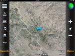
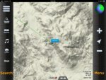
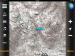
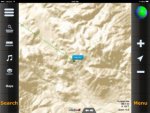
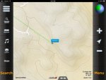
Not sure why the uploader made these smaller.... the images should be 1024x768 (iPad mini resolution) FULL Size can be found HERE


Last edited:
RobRed
Explorer
The iPad has onboard flash (64GB in my case) so space isn't an issue. The map tiles are downloaded via wifi or cellular from a map server of your choice prior to the trip if you are planning. Zoom varies by Map type... the levels in the example (same area in your samples) can be zoomed to 18 which is something like 1:3000 if I had to guess.
matthewp
Combat Truck Monkey
Thats pretty nice.
I'm doing the same thing, just with an iPod Mini. "Self-education" on Motion X GPS was quick and I'm very happy with its capabilities!
SteeevO
Member
How fast does it update your location? I know the lowrances are at 10x a sec. And are crazy accurate
And do you guys preload the imagery? I know from building maps that it takes a ton of space for the hi Res stuff. Im just trying to wrap my head around relying on.cell signal
Sent while mobile, typos likely.
And do you guys preload the imagery? I know from building maps that it takes a ton of space for the hi Res stuff. Im just trying to wrap my head around relying on.cell signal
Sent while mobile, typos likely.
Similar threads
- Replies
- 3
- Views
- 787
- Replies
- 1
- Views
- 406
