Get your tickets to THE BIG THING 2026!
You are using an out of date browser. It may not display this or other websites correctly.
You should upgrade or use an alternative browser.
You should upgrade or use an alternative browser.
Canyonlands, Cap Reef, Bryce, etc: "Utah Sampler" trip report (warning, photos!)
- Thread starter Martinjmpr
- Start date
Martinjmpr
Wiffleball Batter
The story continues...
Day 3, 25 March 08:
Rose early, to watch a gorgeous sunrise and moonset over the Canyonlands and the Henry Mountains to the West.


Rolled out to Hans Flat, trip took about an hour. From there back out the same way I came in to Highway 24, and then down to Hanksville for gas and food supplies. Hanksville is a tiny little town – not much in the way of shops there and you pay their high $$ prices for anything. Just something to consider – try to get everything before you go because if you buy it in these little towns they will sock you for it.
Then it was 95 and 276 to Bullfrog Marina. This was another gorgeous stretch of road, with too many amazing formations to stop and photograph. Just north of the Bullfrog Marina I turned Northwest onto the Burr Trail, an old cattle trail, and headed Northwest towards Capitol Reef. This road is well paved for the first 20 miles, then becomes a well-graded gravel road. Just inside Capitol Reef the road takes a sharp turn to the left and then climbs up over the Waterpocket Fold in a series of dramatic switchbacks.

Up on in the high country, the road traverses the remainder of Capitol Reef and then exits into Grand Staircase/Escalante National Monument. At this point the road becomes paved. The road winds through beautiful vistas of dark red rocks and then through a narrow, high-cliff gorge called Long Canyon.

Just after Long Canyon, the road rises again and eventually dumps out at Boulder on UT 12.
Since I still wanted to see the “main” part of Capitol Reef, I turned right (North) instead of South and headed up towards Torrey. The road then starts climbing significantly, eventually topping out at a nosebleed-inducing altitude of 9500’ (the highest elevation I’d seen since crossing Vail Pass on day 1.) In contrast from the dusty heat of the Burr Trail, which had me running the AC almost constantly, I was now in a sweater with the heat on, and there was 2’ of snow on either side of the road!
View from the Highway 12 summit looking East towards Capitol Reef:

Descended Highway 12 down into Torrey where I stopped again for a few supplies and then turned around towards a couple of informal campsites I’d seen on my way down. Not even a mile inside the National Forest boundary was a road that split off the paved highway into the forest to a campsite that had obviously been used by hunters (judging from the deer skin and empty shotgun shells left behind.) It was getting dark again, and cold at 7,000+ feet, so I quickly made dinner and then crawled into the shell for the night.
To be continued...
Day 3, 25 March 08:
Rose early, to watch a gorgeous sunrise and moonset over the Canyonlands and the Henry Mountains to the West.
Rolled out to Hans Flat, trip took about an hour. From there back out the same way I came in to Highway 24, and then down to Hanksville for gas and food supplies. Hanksville is a tiny little town – not much in the way of shops there and you pay their high $$ prices for anything. Just something to consider – try to get everything before you go because if you buy it in these little towns they will sock you for it.
Then it was 95 and 276 to Bullfrog Marina. This was another gorgeous stretch of road, with too many amazing formations to stop and photograph. Just north of the Bullfrog Marina I turned Northwest onto the Burr Trail, an old cattle trail, and headed Northwest towards Capitol Reef. This road is well paved for the first 20 miles, then becomes a well-graded gravel road. Just inside Capitol Reef the road takes a sharp turn to the left and then climbs up over the Waterpocket Fold in a series of dramatic switchbacks.
Up on in the high country, the road traverses the remainder of Capitol Reef and then exits into Grand Staircase/Escalante National Monument. At this point the road becomes paved. The road winds through beautiful vistas of dark red rocks and then through a narrow, high-cliff gorge called Long Canyon.
Just after Long Canyon, the road rises again and eventually dumps out at Boulder on UT 12.
Since I still wanted to see the “main” part of Capitol Reef, I turned right (North) instead of South and headed up towards Torrey. The road then starts climbing significantly, eventually topping out at a nosebleed-inducing altitude of 9500’ (the highest elevation I’d seen since crossing Vail Pass on day 1.) In contrast from the dusty heat of the Burr Trail, which had me running the AC almost constantly, I was now in a sweater with the heat on, and there was 2’ of snow on either side of the road!
View from the Highway 12 summit looking East towards Capitol Reef:
Descended Highway 12 down into Torrey where I stopped again for a few supplies and then turned around towards a couple of informal campsites I’d seen on my way down. Not even a mile inside the National Forest boundary was a road that split off the paved highway into the forest to a campsite that had obviously been used by hunters (judging from the deer skin and empty shotgun shells left behind.) It was getting dark again, and cold at 7,000+ feet, so I quickly made dinner and then crawled into the shell for the night.
To be continued...
Martinjmpr
Wiffleball Batter
Day 4
Day 4, 26 March 08
Woke up with the sun after a cool night and quickly tore the camp down. Since I was close to town I treated myself to a hot cup of coffee at a convenience store. From there it was East into Capitol Reef National Park.

Another collection of gorgeous, stunning red and white sheer cliffs and fantastically weird formations. Ancient petroglyphs and historic “register rocks” where the early pioneers carved their names added to the attractions.
I took a short but strenuous mile-long hike to Hickman Natural Bridge, a huge natural bridge that arches over layers of white sandstone.

After returning to the truck I continued East through the park, descending down the same formation I’d climbed a day earlier on the Burr Trail. Right outside the park the terrain turns bleak and gray, like piles of leftover dirt were stacked everywhere. I pulled into the microscopic little town of Caineville to turn around.
Maybe it’s the history buff in me, but I’ve always found something compelling about abandoned places. In this case, it was an abandoned schoolhouse….

…and nearby an abandoned Studebaker truck, bleaching in the hot desert sun.

After turning around, I headed into the park from the East, pausing to take a photo of the feature that gave Capitol Reef it’s name: The Capitol Dome.

From there it was quickly through the park, through Torrey and continuing West through Loa, where I stopped for gas. Once again, I was struck by the rapid change in both altitude and climate: Caineville had been hot and sunny. By Loa it was cold and windy. Snow was on both sides of the road.
After climbing up another 9,000’+ summit, I turned sharply West and dropped into the strangely named little town of Koosharem. I continued South on the road that runs through a broad valley, still mostly filled with snow, as heavy crosswinds buffeted me back and forth. By late afternoon I had made it through the little-known John’s Valley North of Bryce Canyon and turned East to head down to Cannonville, where I had a reservation at the KOA.
While Cannonville itself was just another small Utah town, the KOA offered three things I hadn’t experienced in quite a while: Hot showers, electric cooktops and wireless internet access! I availed myself of all three while I tried to shake off the dust of 4 days of being on the road. I set up the truck tent and got to bed shortly after dark. My original plan had been to wake up early, early enough to catch sunrise at Bryce Canyon. But as tired as I was, I doubted I’d make it.
Day 4, 26 March 08
Woke up with the sun after a cool night and quickly tore the camp down. Since I was close to town I treated myself to a hot cup of coffee at a convenience store. From there it was East into Capitol Reef National Park.
Another collection of gorgeous, stunning red and white sheer cliffs and fantastically weird formations. Ancient petroglyphs and historic “register rocks” where the early pioneers carved their names added to the attractions.
I took a short but strenuous mile-long hike to Hickman Natural Bridge, a huge natural bridge that arches over layers of white sandstone.
After returning to the truck I continued East through the park, descending down the same formation I’d climbed a day earlier on the Burr Trail. Right outside the park the terrain turns bleak and gray, like piles of leftover dirt were stacked everywhere. I pulled into the microscopic little town of Caineville to turn around.
Maybe it’s the history buff in me, but I’ve always found something compelling about abandoned places. In this case, it was an abandoned schoolhouse….
…and nearby an abandoned Studebaker truck, bleaching in the hot desert sun.
After turning around, I headed into the park from the East, pausing to take a photo of the feature that gave Capitol Reef it’s name: The Capitol Dome.
From there it was quickly through the park, through Torrey and continuing West through Loa, where I stopped for gas. Once again, I was struck by the rapid change in both altitude and climate: Caineville had been hot and sunny. By Loa it was cold and windy. Snow was on both sides of the road.
After climbing up another 9,000’+ summit, I turned sharply West and dropped into the strangely named little town of Koosharem. I continued South on the road that runs through a broad valley, still mostly filled with snow, as heavy crosswinds buffeted me back and forth. By late afternoon I had made it through the little-known John’s Valley North of Bryce Canyon and turned East to head down to Cannonville, where I had a reservation at the KOA.
While Cannonville itself was just another small Utah town, the KOA offered three things I hadn’t experienced in quite a while: Hot showers, electric cooktops and wireless internet access! I availed myself of all three while I tried to shake off the dust of 4 days of being on the road. I set up the truck tent and got to bed shortly after dark. My original plan had been to wake up early, early enough to catch sunrise at Bryce Canyon. But as tired as I was, I doubted I’d make it.
Martinjmpr
Wiffleball Batter
Day 5
Day 5, 27 March 08
I had already had to cancel or modify some of my previous plans, and as I stated above, I was ready to ditch my plan to wake up early to see sunrise on Bryce. Well, that may have been my plan, but when my bladder woke me up at 5:30am, I said “what the hell? I’m up, right?” So I threw the truck tent in the back of the truck and took off toward Bryce. I was actually rushing, thinking I’d miss the sunrise if I didn’t hurry. Well, I needn’t have worried: I pulled into Sunset Point (much less crowded than nearby Sunrise Point) at 6:55, almost 30 minutes before sunrise. At that altitude (about 9,000’) it was cold, so I sat in the truck to stay warm. There was still considerable snow on the fields and in the forests, and of course, it was also adorning the numerous spires of Bryce Canyon. About 7:10 I got out and walked the trail from Sunset to Sunrise point, where a small crowd, mostly composed of foreign tourists, had already gathered to watch the sun rise.

As you can see, we weren’t disappointed. After a few minutes and a few dozen pictures, I walked back to the truck, intending to have a decent breakfast and a final shower back at the campground.
Around 9:30, I finally left the campground for good, stopping briefly at the Grand Staircase/Escalante National Monument Visitor Center in Cannonville to chat with the bored ranger on duty. He assured me that Cottonwood Canyon road was passable, but warned me that there was construction on the Southern end. I took off down Cottonwood, first passing by Kodachrome Basin state park, which I just didn’t want to take the time to visit. Honestly, I was getting a little tired of traveling at this point and was entertaining thoughts that I might actually be able to make it home tonight, even though it was more than 600 miles away. I continued down Cottonwood Canyon road, which was well graded most of the way. I stopped at Grosvenor Arch, a multi-arched structure just off Cottonwood Road. Very nice and quite photogenic.

While there I talked briefly with two older women, also from Colorado, who were traveling the opposite direction. After a few photos I again headed South.
One word of warning about Cottonwood Road. While the road itself is very well graded and maintained, there are warning signs that the road is impassable in wet weather. This is true and should be heeded! It has nothing to do with the road itself, rather it is the fact that the road crosses numerous low washes, any of which would fill up during the flash flood season.
At about this point, we started following a huge geological feature called the Cock’s Comb. This line of nearly identical triangular hills runs straight to the South and the road follows it, sometimes weaving to one side or another.

About 10 miles North of the intersection with US 89, I started to run into the construction. After having to slam on the brakes and back up to avoid one of those giant dump trucks hauling two huge boulders, I decided to slow down a bit. This is also where the road got extremely dusty and unpleasant. Fortunately, it was just a few miles before I finally came to Highway 89 and blessed, blessed pavement.
I turned Left to go Southeast towards Glen Canyon dam and Page. The first sight of Lake Powell is pretty amazing, even this photo doesn’t really do it justice:

From there it was straight down to the bridge and dam. The Glen Canyon dam has a pretty nice visitor center (albeit with airport-type security!) and an interesting interpretive display on the subject of drought, which the lake is experiencing now. Who knows, with our higher than normal snowpack, maybe it will help fill the lake a bit.
A quick gas and lunch stop in Page, after admiring all the sheer red cliffs, and I took off across State Highway 98 as it wends across the Northern portion of the Navajo Reservation in Northern Arizona. Stopped to snap a photo of Navajo Mountain:

and talked briefly with an older British guy on a bicycle! He had been riding from Flagstaff for about a week and expected to get to page in another day and a half or so!
Continuing across the Rez I finally hit US 160 West of Kayenta. From there I went East and then at Kayenta turned North towards Monument Valley. I had been near Monument Valley several times before, and back in 2000, flew over it on the way to L.A. right at sunrise, but I had never been in it. The road to Monument Valley looked promising, with a large sandstone monument seeming to form a “gate” just outside of Kayenta.

From there it was about 20 miles to the monument and park itself. I had actually heard somewhere that you can’t go into Monument valley without a native guide, but that must have been old information. After paying the nominal entrance fee ($5) I was actually given a map and told where I could drive within the park.
Of course, Monument valley is a classic, iconic Western landscape familiar to movie goers or television watchers. Hell, I remember seeing Marlboro ads featuring Monument valley – in Germany! As with the other parts of the Red Rock desert that I visited, these photos really can’t do it justice – to be there and to be surrounded by this is truly magical.

After spending some time in the park, I continued northeast. Crossed the San Juan River at the odd little town of Mexican Hat, and just outside the town it became obvious where the name came from.

Continued below...
Day 5, 27 March 08
I had already had to cancel or modify some of my previous plans, and as I stated above, I was ready to ditch my plan to wake up early to see sunrise on Bryce. Well, that may have been my plan, but when my bladder woke me up at 5:30am, I said “what the hell? I’m up, right?” So I threw the truck tent in the back of the truck and took off toward Bryce. I was actually rushing, thinking I’d miss the sunrise if I didn’t hurry. Well, I needn’t have worried: I pulled into Sunset Point (much less crowded than nearby Sunrise Point) at 6:55, almost 30 minutes before sunrise. At that altitude (about 9,000’) it was cold, so I sat in the truck to stay warm. There was still considerable snow on the fields and in the forests, and of course, it was also adorning the numerous spires of Bryce Canyon. About 7:10 I got out and walked the trail from Sunset to Sunrise point, where a small crowd, mostly composed of foreign tourists, had already gathered to watch the sun rise.
As you can see, we weren’t disappointed. After a few minutes and a few dozen pictures, I walked back to the truck, intending to have a decent breakfast and a final shower back at the campground.
Around 9:30, I finally left the campground for good, stopping briefly at the Grand Staircase/Escalante National Monument Visitor Center in Cannonville to chat with the bored ranger on duty. He assured me that Cottonwood Canyon road was passable, but warned me that there was construction on the Southern end. I took off down Cottonwood, first passing by Kodachrome Basin state park, which I just didn’t want to take the time to visit. Honestly, I was getting a little tired of traveling at this point and was entertaining thoughts that I might actually be able to make it home tonight, even though it was more than 600 miles away. I continued down Cottonwood Canyon road, which was well graded most of the way. I stopped at Grosvenor Arch, a multi-arched structure just off Cottonwood Road. Very nice and quite photogenic.
While there I talked briefly with two older women, also from Colorado, who were traveling the opposite direction. After a few photos I again headed South.
One word of warning about Cottonwood Road. While the road itself is very well graded and maintained, there are warning signs that the road is impassable in wet weather. This is true and should be heeded! It has nothing to do with the road itself, rather it is the fact that the road crosses numerous low washes, any of which would fill up during the flash flood season.
At about this point, we started following a huge geological feature called the Cock’s Comb. This line of nearly identical triangular hills runs straight to the South and the road follows it, sometimes weaving to one side or another.
About 10 miles North of the intersection with US 89, I started to run into the construction. After having to slam on the brakes and back up to avoid one of those giant dump trucks hauling two huge boulders, I decided to slow down a bit. This is also where the road got extremely dusty and unpleasant. Fortunately, it was just a few miles before I finally came to Highway 89 and blessed, blessed pavement.
I turned Left to go Southeast towards Glen Canyon dam and Page. The first sight of Lake Powell is pretty amazing, even this photo doesn’t really do it justice:
From there it was straight down to the bridge and dam. The Glen Canyon dam has a pretty nice visitor center (albeit with airport-type security!) and an interesting interpretive display on the subject of drought, which the lake is experiencing now. Who knows, with our higher than normal snowpack, maybe it will help fill the lake a bit.
A quick gas and lunch stop in Page, after admiring all the sheer red cliffs, and I took off across State Highway 98 as it wends across the Northern portion of the Navajo Reservation in Northern Arizona. Stopped to snap a photo of Navajo Mountain:
and talked briefly with an older British guy on a bicycle! He had been riding from Flagstaff for about a week and expected to get to page in another day and a half or so!
Continuing across the Rez I finally hit US 160 West of Kayenta. From there I went East and then at Kayenta turned North towards Monument Valley. I had been near Monument Valley several times before, and back in 2000, flew over it on the way to L.A. right at sunrise, but I had never been in it. The road to Monument Valley looked promising, with a large sandstone monument seeming to form a “gate” just outside of Kayenta.
From there it was about 20 miles to the monument and park itself. I had actually heard somewhere that you can’t go into Monument valley without a native guide, but that must have been old information. After paying the nominal entrance fee ($5) I was actually given a map and told where I could drive within the park.
Of course, Monument valley is a classic, iconic Western landscape familiar to movie goers or television watchers. Hell, I remember seeing Marlboro ads featuring Monument valley – in Germany! As with the other parts of the Red Rock desert that I visited, these photos really can’t do it justice – to be there and to be surrounded by this is truly magical.
After spending some time in the park, I continued northeast. Crossed the San Juan River at the odd little town of Mexican Hat, and just outside the town it became obvious where the name came from.
Continued below...
Martinjmpr
Wiffleball Batter
Day 5 (part II)
Continuing Day 5:
At this point I was on BLM land again, and so I headed up State Highway 261 towards Moki Dugway. Besides having a supremely cool name, Moki Dugway came to my attention because of all the warnings and precautions it seems to have inspired. There’s even a warning like this on the Utah state highway map!

The road turns from broken pavement to dirt and then ascends up 1,000’ to the top of the plateu in a series of zigzags and shelf roads. Nothing too spectacular to those of us who grew up in the Centennial State, but impressive nonetheless. And speaking of impressive, here’s the view from the top:

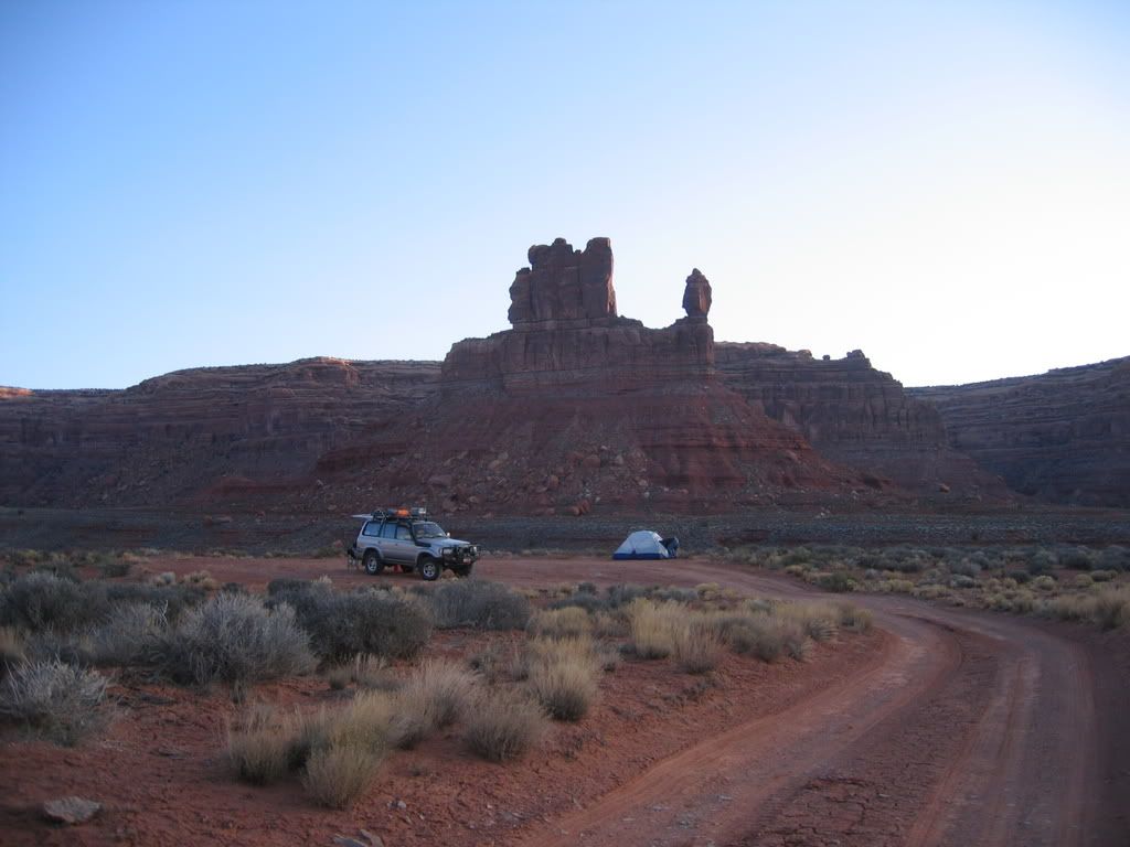
Rather than stay up top, I wanted to see Valley of the Gods, which I had passed just before Moki Dugway. So I descended back the same way I went up and turned left into the Valley.
Valley of the Gods is much like Monument Valley on less well known. It has a number of nice features, not only hundreds of large sandstone “monuments” but also numerous primitive campsites where anyone can pull in and camp.
To me this formation looks like a crash dummy with no arms, facing away from me.

Another gorgeous rock wall:

After passing a few more monuments, I finally found what looked like the perfect campsite. Fare enough off the road that I wouldn’t be bothered by passing vehicles (there were a few, though not many) and with plenty of space.

There was also a fire ring, though I didn’t have any firewood and didn’t feel like gathering any, so I just cooked on my trusty propane stove.
After dinner I set up the truck tent, and after a few minutes of watching the “billions and billions” of stars, went to bed.
Last day coming up!
Continuing Day 5:
At this point I was on BLM land again, and so I headed up State Highway 261 towards Moki Dugway. Besides having a supremely cool name, Moki Dugway came to my attention because of all the warnings and precautions it seems to have inspired. There’s even a warning like this on the Utah state highway map!
The road turns from broken pavement to dirt and then ascends up 1,000’ to the top of the plateu in a series of zigzags and shelf roads. Nothing too spectacular to those of us who grew up in the Centennial State, but impressive nonetheless. And speaking of impressive, here’s the view from the top:
Rather than stay up top, I wanted to see Valley of the Gods, which I had passed just before Moki Dugway. So I descended back the same way I went up and turned left into the Valley.
Valley of the Gods is much like Monument Valley on less well known. It has a number of nice features, not only hundreds of large sandstone “monuments” but also numerous primitive campsites where anyone can pull in and camp.
To me this formation looks like a crash dummy with no arms, facing away from me.
Another gorgeous rock wall:
After passing a few more monuments, I finally found what looked like the perfect campsite. Fare enough off the road that I wouldn’t be bothered by passing vehicles (there were a few, though not many) and with plenty of space.
There was also a fire ring, though I didn’t have any firewood and didn’t feel like gathering any, so I just cooked on my trusty propane stove.
After dinner I set up the truck tent, and after a few minutes of watching the “billions and billions” of stars, went to bed.
Last day coming up!
Martinjmpr
Wiffleball Batter
Day 6 (last day!)
Day 6, 28 March 08
By this point, I have to admit, I was getting a little tired of traveling. Tired of sleeping in the dusty, dirty truck, and tired of driving. I got up and packed up without making breakfast, figuring I’d get it on the road. Would have been nice to get some sunrise shots of Valley of the Gods, but I had a long day ahead of me and wanted to get on the road (actually, as it turned out it was cloudy that morning so it wouldn’t have been worth it anyway.)
Out to the paved road, I turned off of dirt for the last time. Stopped for a cup of coffee and some donuts in Bluff, and then headed East across the Reservation. When I got near the intersection of Highway 160, about 10 miles from 4 Corners, I could see the impressive formation of Ship Rock in the distance.

And then it was straight down 160 through Cortez and Durango, over Wolf Creek Pass and through Del Norte and Saguache. Just past Saguache, I got to see the welcoming sight of my favorite mountain range in the US: The Sangre de Cristos:

And it was just a few hours after that that I finally arrived home in Englewood.
Coming up: Conclusions/Lessons Learned....
Day 6, 28 March 08
By this point, I have to admit, I was getting a little tired of traveling. Tired of sleeping in the dusty, dirty truck, and tired of driving. I got up and packed up without making breakfast, figuring I’d get it on the road. Would have been nice to get some sunrise shots of Valley of the Gods, but I had a long day ahead of me and wanted to get on the road (actually, as it turned out it was cloudy that morning so it wouldn’t have been worth it anyway.)
Out to the paved road, I turned off of dirt for the last time. Stopped for a cup of coffee and some donuts in Bluff, and then headed East across the Reservation. When I got near the intersection of Highway 160, about 10 miles from 4 Corners, I could see the impressive formation of Ship Rock in the distance.
And then it was straight down 160 through Cortez and Durango, over Wolf Creek Pass and through Del Norte and Saguache. Just past Saguache, I got to see the welcoming sight of my favorite mountain range in the US: The Sangre de Cristos:
And it was just a few hours after that that I finally arrived home in Englewood.
Coming up: Conclusions/Lessons Learned....
cruiseroutfit
Well-known member
Great report, some of my favorite places 
Brett M
Adventurer
Moody said:Excellent!!! Great writeup and photos!
Funny...I camped at the same spot in Valley of the Gods a couple of weeks ago:
[IMGhttp://i157.photobucket.com/albums/t44/reugmood/Gods%20and%20Ancients%20March%202008/IMG_2966.jpg[/IMG]
I thought I'd seen that spot recently
")
Martinjmpr
Wiffleball Batter
Paul R said:Great write up!
Do you by any chance have a track log for your trip?
You mean like a GPS log? No, I don't usually keep them (not sure my old Magellan Meridian could do one anyway.) I did GPS the three "primitive" campsites, didn't bother to GPS the KOA in Cannonville or the Panorama Point Campground as they are well defined and easy to locate.
All of my driving was on established roads/trails, so it's not like it's difficult to locate. Unfortunately I don't have a good mapping program to use to show my routes. Can somebody suggest one, preferably one that's easy to use and free of charge?
In Valley of the Gods there are probably two dozen unofficial camping areas you can pull off into. I imagine they probably fill up during the most popular times of the year (even where I was there were two other vehicles camped within a quarter mile, both on the other side of the main dirt road.)
Martinjmpr
Wiffleball Batter
Conclusion: Lessons learned and tips for the future
Okay, so here's what I picked up after 6 days on the road with the Tacoma. In no particular order:
1. I'm not crazy about sleeping in dust and dirt. Since the back of the truck was not sealed against dust, this was a problem. Anyone have any experience dust-proofing a Tacoma bed? I presume that most of the dust is getting in via the drain slots in the bed, but any tips would be welcome. I really hated opening the back of the truck and seeing everything covered in a fine layer of dust!
2. Blackout curtains are a good idea. The moon was waning when I was out, which meant it rose in the middle of the night and was extremely bright. Blackout curtains would have helped a lot and with the liner on the shell, I could attach them with velcro (this is what I did in my previous pickup, a Ford Ranger.)
3. The cab-high shell doesn't make a good camping platform. There simply isn't enough room to move around, it's like sleeping under someone's bed. I'm going to start looking around for a high-rise shell (much like the one I had on the Ranger) very soon.
4. As previously mentioned, I paid dearly (literally!) for forgetting some small items. I wanted to bring a gas can, but the 5 gallon can that would have cost me $7 here in the city was $20 in Green River. The instant oatmeal that would have been $1.50 at a big supermarket was almost $5.00 at the little Quickie Mart in Hanksville. The travel coffee mug (of which I probably have 6 at home, but which I forgot) was almost $12 at Lake Powell.
The lesson here is that unless you know you're going to be passing through a sizeable town, don't just blow off getting some items with the idea that "I'll just pick it up on the road." The map might give you the idea that Green River or Hanksville are big enough towns to have a large supermarket, but believe me, they aren't! And what's worse, I could have picked up everything I needed in Grand Junction if I'd thought about on the way out.
5. I finally got over my longstanding dislike of propane stoves. Even though I like the idea of a dual-fuel stove that can use unleaded gasoline (preventing me from having to carry more than one type of fuel) I have to admit that the propane is clean, not messy, and very easy (and quick!) to use. It never took me more than 3 minutes to set up the stove and get it going and not more than 2 minutes to take apart and stow. My stove doesn't have the "wind break" but I found out that if I put it just inside the tailgate of the truck, it was sheltered enough to make a fine cooking platform and the flames never came close to anything flammable in the truck. Another advantage of the propane stove is that the propane canisters are inexpensive (less than $5 even at the little campground stores) and last a long time, whereas liquid fuel is almost as expensive and is both messy and smelly.
6. The Truck Tent worked great, except for not having enough headroom (which is the fault of the shell, not the tent.) It gave me lots of extra legroom and a nice little "vestibule" where I could set my boots and a jug of water before going to bed. Never took more than 5 minutes to set up or tear down. It flapped a little in the wind, but of course any tent would do that.
7. One little "trick" I tried that really worked: Before I left I bought a case of small (10 oz) water bottles and put them in the freezer to freeze them solid. Then, just before leaving I put them in the cooler. The result was that the cooler stayed very cold (I only had to re-ice once) and I always had ice-cold water when I wanted it. It also meant that I didn't have as much ice taking up space so I had more room for food and beer. Don't know how this would work during a hotter time of the year but it's worth trying.
8. But of course, the best thing I learned is that Southern Utah is awesome and I definitely want to go back! There's lots that I haven't seen: The whole Island in the Sky and Needles districts of Canyonlands, all the trails around Moab, Natural Bridges National Monument, etc.
Can't wait to go back!
:1888fbbd:
Brett M
Adventurer
Martinjmpr said:8. But of course, the best thing I learned is that Southern Utah is awesome and I definitely want to go back! There's lots that I haven't seen: The whole Island in the Sky and Needles districts of Canyonlands, all the trails around Moab, Natural Bridges National Monument, etc.
Can't wait to go back!
:1888fbbd:
Come back anytime! Thanks for the great write up. Makes me want/need to get out in the backcountry ASAP!
Elvota
Observer
Great pics and narration. We have driven on some of the roads you have traveled, especially around the Escalante area. I really like that road from Bullfrog up those switchbacks at the end.
Next time I suggest trying Smokey Mt. Road either in or out of Escalante town as an alternative to Cottonwood Canyon. Really gets you back in there, lots of places to camp and some amazing scenery. It's a slower route... but worth it.
Difficulty is no more than what you have already experienced. I am sure the road itself is on most standard maps and gazetteers.
Similar threads
- Replies
- 29
- Views
- 5K
- Replies
- 5
- Views
- 1K