Creating a Cross Canada Overland Route

deadly99

Explorer
I'd like to say a little bit about our companion Nuvi. A five year old gps unit that really added something to the trip. We came prepared, the route had been researched extensively, locals had given input, etc. Paper maps were on hand as well as two 60 series Garmin units. Maps loaded like topo and Garmin streets, etc. BUT Nuvi knew about "roads" that no one else did and really had an impact on our trip. If anyone wants a real adventure, try driving in North Eastern Ontario and use a Nuvi. We were amazed at the adventures it created. Now I've seen some pretty questionable trails be called roads on maps and gps units but this trip Nuvi took the cake. When your lost hundreds of kilometers in the bush in the middle of a vast widlerness and no map or gps unit can find a way out...Nuvi can...or at least he thinks he can.


You see Nuvi took on a persona of an actual person. "What does Nuvi say", "Nuvi screwed us again", "what the hell is Nuvi's problem". After many of these comments we came to think of "him" as a person. Someone you want to trust but keeps screwing ya over. Nuvi is one twisted son of a %$#@!
 

deadly99

Explorer
Woke up and hit the road early in the morning. We did a quick stop in the town of Huntsville for gas and coffee. Huntsville is a touristy town and offers most modern amenities. Certainly a logical stop over location for folks riding the TCAT. Motels and cabins are plentiful as well as a few campgrounds.

3019679_l.JPG


The route follows a series of dirt roads to the Seguin Trail. This trail is an old rail bed that has been converted into a multi use recreational trail. Great for bikes but sadly we discovered it not for trucks. We found this out after running a section of it where we saw the signs.


3019663_l.JPG


Above: Coming out of the Seguin Trail. Whoops and water crossing are plentiful on this trail :D A fun ride on bikes for sure, it looks like it will become a technical option and the main will follow a mix of gravel and paved roads.


The TCAT follows the Nipissing Ghost Rd. This road used to be an old road with some now abandoned villages, churches and "ghosty" old graveyards. There is some good reading about it on the web for those that are into history. The road begins in the old village of Nipissing (crossroads with the Seguin Trail). There is a section of "road" prior to this crossroads but it is unpassable by loaded bikes so for intents and purposes most folks call this the beginning. A sign that shows the road is posted here.


3019654_l.JPG


And one more in case you didnt notice the decal :D Stepaen lives just up the road from here and works at a vinyl shop. He had printed some decals off for us so we swung by his place to pick them up.....THANKS :freaky


3019631_l.JPG


The road begins as gravel and is fun roller coaster. The odd sign along the way is visble for those who want to stop and read them to learn about the history of that area. The road is broken up now by some pavement and eventually comes to this intersection.


3019625_l.JPG


This section of the nipissing Road is also labelled as the Forgotten Trails. A bit of fun light offroading for the next 6 km's brings you to the finish of the Nipissing Road. It does continue but is only suitable for hikers.


3019630_l.JPG


3019655_l.JPG


3019626_l.JPG


This section is a great addition to the TCAT. Nothing crazy terrain wise but nice for loaded bikes just to add some adventure. A few small rocky areas but nothing to be concerned with. We really enjoyed it and stopped to take some pics and what not.


3019623_l.JPG
 

deadly99

Explorer
Quick video of the first half of the "Forgotten Trails", aka the last bit of the Nipissing Road.


The main section of the ghost road


Last edited:

deadly99

Explorer
The route now follows a mix of paved and gravel roads out to highway 11 and the small town of South River where gas, beer and a general store are present.


3019664_l.JPG


After some research the next section of the TCAT was a bit of an unknown to us. Different maps show different roads following the western border of Algonquin Park. These roads are used for logging in the area. We followed what we thought would be the intended route. After some time we realized we were heading south instead of north, sounds dumb but these roads go anywhere but in a straight line. Eventually we came to a point where the roads seized to exist on the maps and the Garmin 60 series gps's. In comes Nuvi ! No worries Nuvi shows a solid route out of here up to highway 17. Blind faith in the marvelous piece of technology brought us through a bunch of cut blocks on a very slick trail. Winding its way up and around the hills in the area and we were both blown away that Nuvi knew about these recent trails. I say trails because thats what they were, just as wide as the truck and rutted from recent logging vechicles. This area is very sandy and it was a bit wet which was causing some concern for us. My truck is only two wheel drive, its very capable of some fun offroading but speed needs to be applied to get through the hard stuff. the issue lies in when you get stuck you become stuck. We pushed through a few mud section and small water crossing before came to the big hill. We stopped and both looked at each other with concerns in our eyes. Went for it and crested the first hill only to realize another one was right in the way. The picture below does not show how steep this trail was nor who loose and wet the terrain is. Enough is enouogh we said and and we were forced to turn around. Certainly we "might" have made it up it but the terrain was what I would consider not appropriate for the TCAT. We were here on a sunny day, if it was raining this would be a nightmare of a trail for big bikes.


3019676_l.JPG


So we turned around and after an hour or two fund some gravel roads that lead towards the city of North Bay.

3019624_l.JPG


3019658_l.JPG


3019657_l.JPG


North Bay is for me the "gateway to the north". Bike shops for most brands, nig hotels and every other thing you miht need from a city can be found here. This is the first time since Ottawa that folks will have been in a city (3-6 days ago on the TCAT). We had some lunch and explored the city for a bit. I found it to be a clean and friendly place and quite enjoyed it.

Local farmers hard at work outside of North Bay

3019622_l.JPG


We pushed on in hopes of findings a campground. The one we stopped at was down an old backroad and when we pulled in the lady comes out wearing mesh bug gear. Odd I thought as it doesnt look like there are any bugs. immediately after getting out of the truck the black flies invaded me. ears filled up and my hair was getting thick with them. I asked if we could camp on the lake where the wind would fight back the bugs and she replied no the tent sites ar in the bush. Sorry lady but no way! A few miles down the road we cam to rundown old motel. 50 bucks for two people is I think what we bargained them down to. Heck that only a few bucks more than camping and since we were packing food it made good sense.


3019672_l.JPG


Settled in and uploaded the pics and vids from the day.


3019675_l.JPG


Don came out to play after some nice sirloin burgers cooked on the bbq. Other than getting lost for a while on the west side of Algonquin Park this was really beginning to feel like a vacation instead of an exploration expedition....that will change tomorrow :deal


3019621_l.JPG
 

deadly99

Explorer
WAKE UP WHERE'S THE KEYS!!!

So I snore, apparently I snore loud enough to wake Ewan up and drive him crazy. So Ewan slept in the cab of the truck for the rest of the
night....sorry.

We hit the road running and after a quick stop at a Home Depot to fix a loose fender on the truck. The goal today was to drive the Portelance Road from north of Sudbury to a town called Shining Tree. It looked to be about a 110 km's in length. This road was recommended by Gord as an alternative to the Sultan rd we had originally planned on using. Good call Gord, she is a beauty. The second part of the day was to use an unnamed road from Shing Tree to the city of Timmins. This road looked to be about the same distance. Given that Ewan had barely slept the previous night...our goal was to be off the road by 3pm and to spend the night out on the town and meet some locals.

I'm no writer but I'll try my best to make a few parts seem as exciting as they were to us.....

The Portelance Road was not quite what we had expected. I had presummed it was a big gravel highway you could blast down. Instead its a great back road that is tight and winding. It starts off by following the XXXX River. Nice rocky walls that road is carved into, small wooden bridges to cross, nice hills as a back drop. Truely it was very enjoyable and a perfect road for the TCAT. What we were not expecting was all the intersections. Left or right? Maps we had did not show the area well as they only showed a through road and none of the side roads that I presume are built by the local logging companies. Problem is the side roads are the same siz as the main road and look the exact same.


3019769_l.JPG


3019751_l.JPG


More than once we wondered if we were on the right road. Nuvi came into his own here as he clearly showed us a big colored line going right to where we wanted to end up. At this point Nuvi was a great travelling companion. The road continued and got a bit rougher. We encountered about a dozen washouts along the way. Some were deep enough to warrant getting out and filling with deadfall and stones.


3019775_l.JPG


All of a sudden Nuvi demands we turn left at an intersection. Hmmm....this road certainly doesn't look the main road. We check all the GPS's and they show the main road ending in about 10 km's. Left it is I suppose, thanks Nuvi. Well this road got smaller and smaller and the trr's began to get quite tight. Thoughts were exchanged and we decided that we'd try it out as there is cleary a way through according to Nuvi and the terrain was just nice smooth double track. A dozen or so km's into the trail things began to get a bit rough, not crazy but certainly interesting given where we were in the world, the fact we were by ourselves and we didn't have a 4x4 or a winch.


3019763_l.JPG


The trail, as it clearly became a trail and not a road anymore started following some hydro lines. Damn this is going to be sweet for the route! I can't imagine Gord not mentioning the part where the road joins a hydro line and starts climbing up and down these rock formations. A while later the trail swings into the bush for a while and we begin climbing a good sized hill. The trail is just wider than the truck. So up we go with concern and we turn the corner and right in front of us is a BIG hill. Now its worth noting that Ewan and myself had just earlier had a conversation about how crappy a truck is on a hill compared to a bike. For one thing you can no longer see in front of you and for another stopping is almost not an option as trying to go back down backwards is a recipe for disaster.


3019773_l.JPG


3019750_l.JPG


"WE'RE FEEKED" I hear Ewan yell, as at the top of the hill climb is what appears to be a solid wall of rock about 4 or 5 feet high. No turning around, we're committed so I give it everything the truck has. This thing has a bash plate for a reason. By the time we hit the top we are in first gear at red line on the rpm gauge and I cannot see anything. The truck is bouncing around off the rock and voila we're up on top. The rock wall had a slant to it and wasnt nearly as bad as we'd thought from our point of view from further down. We took a break to let our hearts calm down and had a good laugh at Ewan's comment. Crazy? It certainly was at the time for us. We pushed on and followed more of the trail until we got to a spot where it became very muddy. our cardinal rule is to NEVER go through something you won't be able to make it back from. "Damn we're screwed"...I guess we'll find out if the main road continues or stops like the maps say. Back we go down the trail. Sorry no pics from this stretch as the cameras were forgotten in the excitement.

This where we turned around as it got very muddy around the corner. thats big time disappointment on my face and frustration :cry


3019764_l.JPG


Well the road continues. It certainly becomes narrower and in rough shape but it kept going. thoughts of being turned back and having to try the side roads we'd passed earlier in the day didn't seem like much fun. About a dozen washouts to keep things interesting. A half hour or hour of this and voila the road gets big and wide again. This is what we had anticipated, a huge road with logging trucks barreling by creating dust storms. About 30 km's of this and we popped out onto the anticipated highway 101.


3019768_l.JPG
 

deadly99

Explorer
So there's not much around these parts on the map other than a town called Shining Tree. Well this "town" is not vacation paradise let me tell ya.


The gas station. The center of town...looks like its been closed rfor some time


3019777_l.JPG


There is small general store around the corner in town but it only sells propane.


3019780_l.JPG


It turns out this town is an Indian reserve and didn't have much prosperity going on.

3019784_l.JPG


I enjoy the native culture and was explaing to Ewan how it would be cool to see a teepee full of natives, well low and behold a teepee right up the road and what comes out but about a dozen natives. Worth noting that Ewan was calling me an idiot for saying I'd like to find a teepee full of Indians :deal Weird but true as there was not another person around. If we hadn't of seen them I'd have thought the town was abandoned.


3019786_l.JPG


The ever important map. For me a map gives a view at the bigger picture where as gps makes me have tunnel vision and it becomes easy to lose focus on where you really are in relation to roads and towns.


3019783_l.JPG


Upwards and onwards, a quick check of our gas situation shows we used a half tank. No worries as the next section is surely a gravel highway that leads from here to Timmins. The maps show it as being right outside of town. Well we saw only one road called Grassy Road and even the Nuvi showed it ending about 40 km's in. We did some back and forth on the highway before low and behold Nuvi to the rescue. Nuvi says there IS a road and goes right to Timmins. yehaa!! Having to take the highway around would have been a real shame. Off we go to find the road, an ominous feeling as the road is a double track trail that starts at the back off a rock quary. What makes a trail a trail instead of road? Grass growing up in the middle for one thing and it starting at the back of a rock quary for another !

We double and triple check the gps and it certainly shows it going all the way through. 120 km trail...hmm....this could be epic. Things started off
smoothly and after a half hour began to get a bit hairy. The trail narrowed and the tree's began to scrape the side of the truck, a nice washout just after a half collapsed bridge and some mud all began to make us worried. The trail then jumped onto a hydro line and began climbing. Hills make me nervous for some reason when I'm not on my bike. Eventually the trail splirts with a very little used trail following the hydro line and the right branch being what looked like the "main" branch. 10 more km's in and we realized we were no longer following Nuvi's suggested route.


3019749_l.JPG


3019750_l.JPG


It can't of meant for us to take that branch up the hydro line could it? 80 point turn to get the truck turned around and back we go. Indeed it means for us to go this way. Off we go before encountering the mud.

3019779_l.JPG


No way Jose so we turn around and head back to the highway feeling very discouraged. Nuvi screwed us again! You'd think we would learn not to trust him and that this day was about to end...well you'd be wrong, very wrong :deal
 

deadly99

Explorer
The only real sign of life was a fishing lodge so we pulled in and asked the fellow where this road was that our map showed. I explained where we had tried to get through and he laughs and says even an atv wouldnt have made it, the trail has been forgotten for years. He asks why I dont just take Grassy Road right to Timmins as its a smooth gravel road and about a 100 km's in length. Why not indeed...ARG! Nuvi ! Second time today that bugger tried to screw us over !


What to say about the Grassy Road? Awesome ! Smooth sandy road that is a roller coaster and goes for just over 100 km's. Only one small washout and one tree across the road, other than that the only obstacle was the occasional dust storm from oncoming traffic. About half way we took a break and had a snack. The weather was great, no bugs, about 24 degrees celcius out and the sun was shining. We're half an hour from a hotel, shower and a night on
the town...YEHAA!!!


3019747_l.JPG


3019748_l.JPG


3019746_l.JPG


We roll into Timmins and stop at the first motel we see to check rates. Being a Wednesday we figure we should be able to bargain for a good rate. Wrong, every motel is sold out in town and so are the ones in the towns within 150 km's of Timmins. There is some sort of mining convention going on and its the busiest week of the year.


3019677_l.JPG


Total burn on Ewan and he was really looking forward to a power siesta (in his own room) and a night out. Limited choices at this point so we decide that since its only 4:30 pm we can do the gravel highway to the next town on the TCAT, Kapasaksing. Again we have a bit of a struggle finding the road on a map. Juts west of town we find the biggest, widest gravel highway I've seen. It says 70 km's to some mine and Nuvi is saying there is a way through, mind you its 164 km's. Yehaa, a bonifide gravel highway. Time to make some miles! After about 30 km's of us doing Dakar speeds Nuvi says take a right. Hmmm...this one in't quite a higway but a gravel road, who cares its a well used road and heading in the right direction.


3019745_l.JPG


Just to keep you on your toes ...


3019774_l.JPG


These folks OWN the roads. Once one see's you, you become known on the cb's. Until then your a ghost out there, I'd encourage you to be careful :deal


3019762_l.JPG


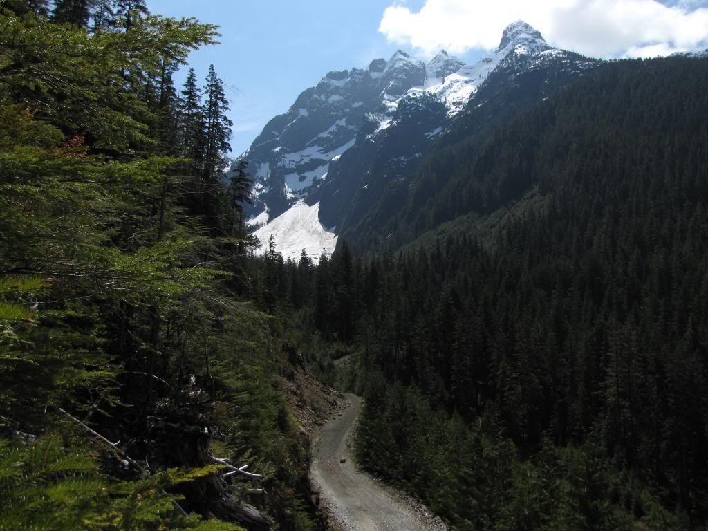
Is the outcome of this predictable? The roads get narrower and rougher. The road turns into a trail. The Trail gets rougher and at times quite thick
with sand. Our chosen route needs to change but Nuvi has everything under control .....


3019776_l.JPG


We begin to encounter water crossings. the sand around here gets a bit slick when wet and given we don't have four wheel drive the technicque to water crossing is to hit them at speed. Once you get into it you can't see squat, even with the wipers going at full speed. Down shift as required and hope when you come out the other side you are still on the road. this goes well for the first few until we get to the big one. Remember early when I mentioned the golden rule about not crossing anything you aren't a 100% sure you can come back across? We debate it. In the end the gps says we are 50 km's from town so we decide to role the dice.Attack in second gear, down shift blindly into first and revving the crap out of it then nothing. It stalls or rather cuts out. 2 seconds later the windsheild clears and voila we are ouot of the water sitting comfortably on the road even. A quick turn of the key and the engine won't turn over. A quick desperate and paniced look at Ewan shows his face is saying the same thing. Two more tries and the engine won't turn over. We both quickly unplug the firdge and other electronics from the vechicle as we both know that you don't get too many tries out of a battery and we are a long way out into the middle of nowhere and the chances of anyone coming along for the next few days are slim to none. How long does it take to walk 50 km's of trails and what do you do to get a vechicle recovered from out here anyways. No towtruck is making it back here. One more try with the key and just
before turning it back the motor does a slight turn over. Hmmmm...try again and it does the same but when I turn the key back it stalls again. **** is what we are both thinking, we pause and don't say anything. One look at Ewan and he nods, we both know this is probably the last try. It starts and I keep the key turned and try to pump a little gas, it stalls! All of a sudden I have turrets as the tension comes out in a tidal wave of verbal diahera.

One last try and it starts! I think I'm shaking a bit at this point from the nerves.

We head on down the trail and it begins to get very sandy, wet and rough. Hey a bear, hey another bear! Okay this may sound made up but Ewan will destify that all of a sudden we were in what appeared to be a zoo full of bears. We came up on one who wouldn't even budge off the road. twenty feet we pulled up in fornt of it and it just stood there staring at and it didn't look happy. Eventually he slowly walked down the road and into the bush. Holy crap we both say, imagine we were on bikes. We stopped a bit further ahead to take a piss and the bear prints in the mud were crazy. First off they were everywhere and secondly there must have been one big son of a gun as one set of prints were massive. Bigffot massive and very fresh. Needless to say it was a quick break. One bear is worth mentioning more than the others as it was huge. Watching him run down the road in front of us was amazing. Muscle or fat I don't know but his entire body was rippelling as he ran, it was very cool to see.The trail began to get narrower and narrower the further we went, for a strecth it was only atv width (about a half of what my truck tires are) and we had to decide if the left or right tire road in the rhubarb. This went on for dozens of kilometers (or so it felt), the entire time we are madly checking the gps to see how much further we had to go. 6.3 km Ewan would say, 10 minutes later one of us would check again and it would be 6.23 km's, lol. Not gonna say panic more like anxiety goping on as it was getting a bit late and we REALLy wanted to get to that highway. Every time you came around a corner and it was dry and straight a surge of joy would go through me, yehaa 300 more meters down. We were crawling in first gear at this point in the game and the engine starts to surge...yikes.

Well it was not too be, 4 yellow metal poles in the ground were around one of the corners. NO!!!!!!!!!!! Leave the truck running and run up to them and yank it out of the ground (yes I put it back). If it hadnt of come free I think I intended to just ram it with the truck and drive over it. Look at the width of the bride Ewan says. Holy crap, a brand new frsh lumber looking bridge with a sign saying something to the likes of "built ny the Smooth Rock falls ATV Club" or something like that. Nice bridge and all but maybe you could put a sign back on the road about 80 km's saying no exi5t for trucks !!!!! Well maybe most trucks dont come this way, lol
Really, freaking really....six more freaking kilometeres! really ? Back in the truck and discuss what to do. We should just camp here and head back in the morning. The forecast said maybe some rain tonight, what would that do to the trails as we barely made it here in the first place. The only food we have is raw beef and a barbque, we are gonna be watched by bears big time if we start cooking steaks out here is what we discussed. ya no freaking way am I spending the night here, its way to freaky knowing that we are in a bear zoo. It would have been like in a horror movie where some one says seriously, you walked into the dark abandoned house? Keep in mind I'm no stranger to living with bears and other wildlife. I live on a dirt road in the country and we have bears and wolf sized coyotes within 100 feet of the house at times, but seeing bears that dont get scared of a moving truck and all the noise it creates freaks me out. 15 years ago I did a year at college doing an outdoor mountain course. One of the classes was taught by some old swiss dude and I remember very clearly him saying "forget everything you know about bears and remeber this, they are like humans and everyone once in a while you may run into an assh0le. Well I think this place was full of assh0les :nod
Back, I can't believe we have to go back. To where..Timmins was the decission and we'd figure out what to do there. Find a campsite outside of town or something. Again through the bears, one ran down the road in front of us for a while and even did a small water crossing for our viewing pleasure. I have limited pictures of the bears as I was either too freaked out to take photo's or they came out super blurry.


3019730_l.JPG


We made much quicker tikme getting back the 160 km's to town as we were now on a mission, to make it back before dark. We got into Timmins around 9 pm just as it was getting dark. Truck can really soak up those big hits :thumb After all the Dakar driving we were pumped, first time I ever got blisters from a steering wheel.


After making it to town we stopped and made some choices. The first logic behind it was if there is no way through to Kap on gravel then I may have to alter the route and head west, the second being we didnt feel like driving a couple of hundred km's on salb to kap and then ride the loop around Abitibi canyon if it wasnt goping to make the TCAT. Money and time off work are limited and there was no way we were going to figure out another road sitting around up here. I'd spent a fair amount of time finding this road, posted the route on local forums, etc and no one mentioned a newly build narrow bridge :cry


So we bombed south and drove for a hour or two to a town called New Lisgard. Booked into a cheap motel and headed into town to see what we could find at close to midnight. One pub open with three little squirtsa doing very loud kareokee. bad tunes from the 80's at that, Vanilla Ice is the one that rings a bell. Needless to say the stop was quick but the cold whiskey certainly tasted good. Time behind the wheel for today was about 16 hours and we did about 1100 km's. Keep in mind alot of that was exploring back roads and heqading up obscure trails. This day was a long and tiring day. Sleep came easy might be a better way to put it.


So there it is, the first stab at pushing the route this year, over the coming months I look forward to hearing from the other folks involved and seeing some pics from their area's of Canada and hearing their tales of adventure. I am a bit biffed we got turned back but in the end we did get some solid terrain for the TCAT and pushed the trail quite a way north. These new additions fit perfectly with the intent of the TCAT, remote non paved roads that bring you to places you might not ever have otherwise seen :thumb
 

deadly99

Explorer
So summer has finally arrived in Canada and everyone involved with the project is gearing up to ride/drive their shares of the TCAT :)


From the province of Saskatchewan.


I photoed these fellows near the proposed TCAT route last weekend. They are the most entertaining critters in the woods.


Chillin after a big meal


May%2015%202011%20bear%20038.jpg


The young lads, these guys are the size of a loaf of bread


May%2015%202011%20bear%20006.jpg


May%2015%202011%20bear%20011.jpg


This was momma keeping track of the kids


May%2015%202011%20bear%20043.jpg


May%2015%202011%20bear%20049.jpg


From Ross who is doing the bulk of the BC portion of the route

With such a large snow pack this year in BC, it's not yet possible to get up into the high country to ride any of the passes the TCAT will be taking, so I did some exploring of roads below 3000 ft.

Not sure if these roads will make the final cut, but it sure was nice to be out actually riding some of the proposed route.


i-ZQ46FkN-XL.jpg


i-pqWfKRB-XL.jpg
 

deadly99

Explorer
No problems, glad your enjoying the read.

This photo is from Vancouver Island near the terminus for the route. It was taken last weekend by the fellow who is doing that part of the route.

IMG_2270.jpg
 

Yorkie

New member
You are supremely brave doing those water crossings in the middle of nowhere in a 2wd truck. I'm sure you could have got someone from OLC to tag along. Anyway great progress.
 

deadly99

Explorer
Here comes a good one

We had 60 bikes attend a pre ride of the TCAT in eastern Ontario this past weekend. The "event" was nicknamed the Roaming Rally. Enjoy the read, its a long one with tons of vids and pics :smiley_drive:

The route we put together was a slightly modified version of 2-3 days of the TCAT. The goal was first and foremost for everyone to have fun and be safe. The next goal was to get a feel for the gps files and how accurate they were, to see how the optional technical sections were suited to loaded bikes, to see what the main route of the TCAT was like in regards to terrain, scenery, etc. This section of the TCAT goes through my backyard. Juames and myself have spent many, many days putting it together over the last year. The TCAT has many sections (even weeks at a time) where big wide gravel highways are the only terrain, the "harder" parts of the main route are spread out here and there. Skibum has a few days on a rail line that he says can be challenging, I've seen some of Chris's section in Sask and can imagine it becomes very challenging when wet and slick, etc In between these are days of cruising gravel roads. I want to say that this section of the route is not the norm....but I think there will be a few area's where the terrain is similar to this.

After hearing many folks thoughts here is what I came away from the event with.

1. The technical optional (Hero) sections are suited to experienced riders who want to have a small challenge or enjoy rougher terrain. Folks seemed to enjoy them.

2. The main route is challenging when it gets wet. This is inevitable and predictable.

3. Knobby tires are a must

4. Beavers can make a lake in one day where there was almost nothing the day before.

5. Washouts can occur which will put a river across a road.

6. Not everyone knows how to use a gps

7. GPS units that don't do tracks and are not suitable for the TCAT ubnless you are a gizmo wizard


So is the terrain too challenging for a 15, 000 km route? I think I'll stand by our choices and say no. The trails used for the main are dead easy when dry. When wet they do become challenging for sure, but then so does any clay or dark dirt surfaced road.

I look forward to hearing others reviews, comments and suggestions in regards to the terrain for the TCAT
 

deadly99

Explorer
Thursday evening a bunch of us met up for a pint or two at a pub in Ottawa. It was good to put a face and a name to the advrider pseudo names we all go by. A real mix of folks from all over Canada and the US. I was amazed at some of the distances folks had travelled. 960 km on a dr350 with only stops for fuel :huh

3024658_l.JPG


3024659_l.JPG


3024660_l.JPG


3024661_l.JPG


3024670_l.JPG


3024673_l.JPG


3024671_l.JPG


Check out how clean these bikes are :evil


3024674_l.JPG


3024662_l.JPG


3024668_l.JPG


Stayed at the pub (Darcys) until about 11 before heading home for some sleep before the event started early the next morning.


3024669_l.JPG
 

deadly99

Explorer
Friday morning started off cold and wet. On the ride to the meetup point I watched a bike slip on the asphalt in the middle of a busy intersection...hmmmmmm.....not a good sign :deal

Andrew (FreeThebeast) was the official organizer of the event and neither of us are big on public speaking. We met everyone at the meet spot and did a quick "safety" and "welcome" speech to everyone before hitting the road.

FTB looking...intense?

3024595_l.JPG


Bikes in the parking lot


3024596_l.JPG


Everyone hit the road at their own pace and the rally was on. The first little bit of the main goes down this decommsioned road ouotside of a town called Merrickville.


3024652_l.JPG


Rob and myself had exchnaged many emails over the last year about different routes, trucks and bikes. We had a chance to meet and shoot the **** for a bit and watch some folks cruise by


3024651_l.JPG


As predicatble it was slick. I caught up to a few guys and as I came around a corner I see a 12gs spinning on its cyclinder head and a pannier lying beside it :huh


Ceruised through Merrickville and meet some lads ata train crossing they asked about the first tech section so I showed them the way and jumped into it. Narrow, MUDDY with fallen down tree's. Took longer than anticipated to get threw it as a big 950 doesnt like cutting therough thick bush to get around fallen tree's :deal My house is about 300 yards through the forest from where I got myself good and stuck with no one around to help. I kept thinking well this is just going to be embarrassing if this is how far I make it....


The entrance to tech01

3024579_l.JPG


Meetup with some folks along the route and we rode together for a couple of hours to the beginning of tech02 (Burntlands)

3024589_l.JPG


3024592_l.JPG


3024590_l.JPG


Sweet gloves :rofl


3024586_l.JPG


3024591_l.JPG


3024587_l.JPG


Frank....didn't see you the entire event after this photo :deal ? :lurk


3024600_l.JPG


3024605_l.JPG


Met this fellow (below) Nolan. We charged into tech02 and had a great time. Tons of water, cool rock formations, etc. Near the end I came upon a log lying across one of the water crossing. Long story short is I can't lift the front wheel of my 950 when I am in a foot or two of water :deal Splish splash I was taking a bath :nod Ejected from the bike and landed flat on my back in the drink...it was cold. Nolan helped me get the bike back up and running and away we went. I really enjoyed this part of the route and I think Nolan did to as he had a BIG smile on his face.


Met some more folksd after the tech02 and we followed the main for an hour or three. The trail parts of the route were very slick and made for some slow going. On a dry day you can really zip along, today was a slow crawl.


3024613_l.JPG
 

deadly99

Explorer
One of the lads with us took a slip in the slick stuff and wrenched his shoulder pretty good, Dave hit a rock and broke his gear shift lever in half. It was about 3 pm at this point (the pre arranged bail out time) so I decided to join these two lads and head to the camp ground. This was just before California Road and the subsequent "DEEP" water that wasnt supposed to be very deep. Just for the record I have been riding through it for a few years in ALL conditions and its always been doable. Apparently the beavers were busy last week as the levels were apparently to high for most bikes :huh I'm sure ALOT of photo's and vids were taken as the campfire stories were plentiful.


3024629_l.JPG


3024621_l.JPG


All day there was one track ahead of me. I REALLY wanted to catch that bike but travelling in a large group slows down the pace. I found out it was Boatman and he was the only one to finish the entire route on day one..including all the tech sections :thumb Kudo's to you :clap


Quick fillup and a warm coffe in calabogie before heading to the campground.


3024637_l.JPG
 

Forum statistics

Threads
188,471
Messages
2,905,523
Members
230,428
Latest member
jacob_lashell
Top