You are using an out of date browser. It may not display this or other websites correctly.
You should upgrade or use an alternative browser.
You should upgrade or use an alternative browser.
Floridians do Utah (a traverse plus some other stuff)
- Thread starter 40tude
- Start date
40tude
Adventurer
I would on ih8mud, but i've been reading it here. also, I think the mud guys are much more into simple 4x4 versus overlanding and if they are they hang out here more. Also, this is amazing, I need to do this. feel like doing this again in a year or two? - Korasher on ih8mud.
Ha! I feel like doing this full time!
40tude
Adventurer
You still have not told me how this trip was, so I am glad to be reading it and seeing the pictures. Just wish you had been able to swing by and see us in Colorado while you where here. Next year I guess.
You better have the 4runner along for the ride next time
TheGreenBeast
New member
Ha! I feel like doing this full time!
haha, dude. I've already started brainstorming a expedition touring business. just need a million or two to outfit some vehicles (earthroamer, sportmobile and cruisers...) to explore the American Frontier for a fee...
40tude
Adventurer
Day 8 June 20, 2012
This was probably my favorite day of the trip. We woke to a gusty but beautiful morning in the aspen forest. After a quick breakfast we hit the road with fingers crossed, hoping there would be no more exhaust issues.
The first portion of the route was a nice drive through the aspens along Gooseberry Road. This was a beautiful area and looked to be prime elk country. We didn’t happen upon any elk but did see this muley in full velvet.

Next up was Beef Basin Road towards Canyonlands National Park. Throughout the years I have seem the names Beef Basin, Lockhart Basin, etc. talked about, and it was very cool to actually be driving them.
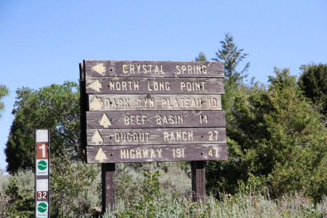
Beef Basin was a nice easy drive for the most part, it provided fantastic scenery, along with some evidence of earlier dwellers.


Beef Basin does get a bit more interesting at the end at a section called Bobby’s Hole, but it is much easier on the south to north route rather than the other way around (lucky us).

Not long after Bobby’s Hole is the entrance to Canyonlands. At this entrance there is nothing but a sign, no rangers, no buildings, no people. (I guess if you put in the effort to come in through this way, they aren’t too worried about who gets in or out.)
At this point we were coming into the Needles district of Canyonlands. Just driving into here was breathtaking. The needles look otherworldly, we had a long period of awe and wonder made all the better since we were the only ones around.


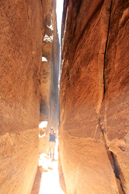
I had heard some things about a place called the joint trail, so this was the first on the list to check out. The only way to know where to go on this trail is to follow the stacked rocks, there are no other markings.

I cannot do this place justice with any descriptions, all I can say is do this hike it is something you will not regret.


Next up along the route was Elephant Hill, this is strictly a 4x4 trail and can be fairly technical. It is only a few miles long, but took every bit of a couple hours to complete. The Mrs. did all the spotting (which she is very new to). At the point we had both run out of nerves, so the going seemed easier. I should also remind you that at this point my compressor was broken, so I was driving a fully loaded/ fully armored 80 series with the tires at 40 psi.. The traction could have been improved, but we pushed through successfully. Also as usual, during the tougher 4wd sections we were not thinking about pictures, just safely getting through.

We had planned on going to the ranger station (at the real entrance) to get a camping permit for the night, but apparently they close at 5pm. We decided that with a little time to kill we should fuel up for the next leg at the Needles Outpost (right outside the entrance and the only fuel anywhere near) but they were also closed. Soooo...now to find camp.
We found a nice little area of the side of Lockhart Basin Road, with a view of Hamburger rock. There was time to kill, so I went around shooting things with my slingshot (most fun $5 can buy), while Mrs. 40tude played with the camera.


This was probably my favorite day of the trip. We woke to a gusty but beautiful morning in the aspen forest. After a quick breakfast we hit the road with fingers crossed, hoping there would be no more exhaust issues.
The first portion of the route was a nice drive through the aspens along Gooseberry Road. This was a beautiful area and looked to be prime elk country. We didn’t happen upon any elk but did see this muley in full velvet.

Next up was Beef Basin Road towards Canyonlands National Park. Throughout the years I have seem the names Beef Basin, Lockhart Basin, etc. talked about, and it was very cool to actually be driving them.

Beef Basin was a nice easy drive for the most part, it provided fantastic scenery, along with some evidence of earlier dwellers.


Beef Basin does get a bit more interesting at the end at a section called Bobby’s Hole, but it is much easier on the south to north route rather than the other way around (lucky us).

Not long after Bobby’s Hole is the entrance to Canyonlands. At this entrance there is nothing but a sign, no rangers, no buildings, no people. (I guess if you put in the effort to come in through this way, they aren’t too worried about who gets in or out.)
At this point we were coming into the Needles district of Canyonlands. Just driving into here was breathtaking. The needles look otherworldly, we had a long period of awe and wonder made all the better since we were the only ones around.


I had heard some things about a place called the joint trail, so this was the first on the list to check out. The only way to know where to go on this trail is to follow the stacked rocks, there are no other markings.

I cannot do this place justice with any descriptions, all I can say is do this hike it is something you will not regret.


Next up along the route was Elephant Hill, this is strictly a 4x4 trail and can be fairly technical. It is only a few miles long, but took every bit of a couple hours to complete. The Mrs. did all the spotting (which she is very new to). At the point we had both run out of nerves, so the going seemed easier. I should also remind you that at this point my compressor was broken, so I was driving a fully loaded/ fully armored 80 series with the tires at 40 psi.. The traction could have been improved, but we pushed through successfully. Also as usual, during the tougher 4wd sections we were not thinking about pictures, just safely getting through.

We had planned on going to the ranger station (at the real entrance) to get a camping permit for the night, but apparently they close at 5pm. We decided that with a little time to kill we should fuel up for the next leg at the Needles Outpost (right outside the entrance and the only fuel anywhere near) but they were also closed. Soooo...now to find camp.
We found a nice little area of the side of Lockhart Basin Road, with a view of Hamburger rock. There was time to kill, so I went around shooting things with my slingshot (most fun $5 can buy), while Mrs. 40tude played with the camera.


4x4x4doors
Explorer
Reading, watching, enjoying. Subscribed.
Awaiting the next installment! :coffeedrink:
Awaiting the next installment! :coffeedrink:
huskyfargo
Adventurer
subscribed! Thanks for sharing the maps so I can add some of this to my expedition out west next summer.
40tude
Adventurer
looks like a great trip! Awesome pictures and good story.
oh yea, being in the cattle business myself, I wanted to say thanks for supporting the beef industry with your bumper sticker!!!!!!
haha anything to help
40tude
Adventurer
Day 9 June 21, 2012

We woke up to another beautiful Utah sunrise, and quickly headed back over to the Canyonlands visitor center to get some maps and paraphernalia. We talked with the ranger for a bit and discovered the the Needles Outpost (gas) did not exactly have set hours of operation (She said about 9ish or whenever they get up.), so with time to kill we drove around the park for a short while.

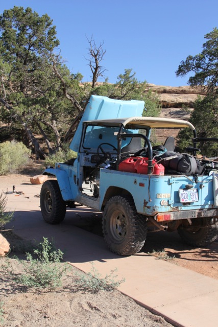
This was also a perfect time to fill our water cans back up. At the filling station we saw this FJ40, apparently they had driven here from Oregon to do some wheeling.
We soon made it back over to the Needles Outpost and were met with this lovely little sign.
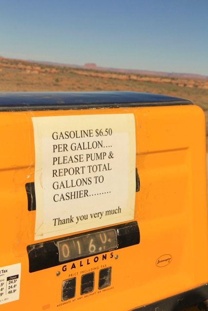
OUCH! I knew that I needed a full tank for the trip up Lockhart Basin today, and did not want to use my 2 jerries in case I needed them in an emergency. So 16 gallons filled us up (and drained our wallets). The owner/cashier lady was pretty excited about the sale though. We talked with her about Lockhart Basin a little and she seemed like she had traveled it a few times, and said how much fun we would have. She then told me I would be fine, “Since I was driving a NAVIGATOR.” !!!!!?????(again OUCH)
From researching before the trip I knew that this a long, seldom used road with a couple technical/ dangerous sections towards the end. With slight apprehensions we pushed on towards Moab.
The beginning of Lockhart Basin (from north or south) itself could easily weed out any vehicles that should not be using this road. On the northbound route that we were on, the beginning starts with a steep hill of deep sand. It took us a couple tries just to get up this (the answer was more throttle).
I do not know how to describe this route very well, it is a rocky trail, followed by rocks and more rocks, I have never seen so many rocks. There is virtually no shade. There are no relaxing bits. There is nowhere you can go quick to make up time. It is a slow plod along navigating the boulder strewn trail.

All in all this trail took us 7 hrs of straight driving in low range. (If it had not been for our earlier trials and tribulations, this may have been stressful, but by now we were getting to be veterans of this whole thing.) Mrs. 40tude was carefree in the passenger seat.
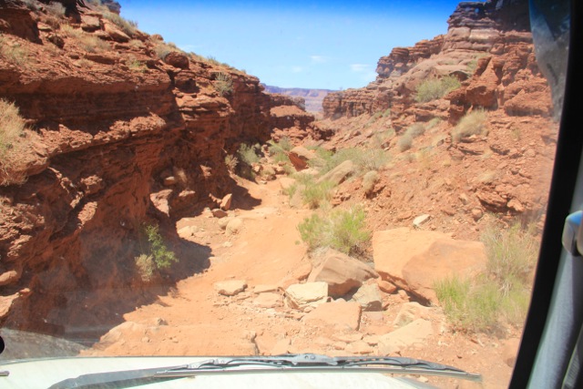
The challenges came towards the end of the trail, but yet again the camera seems to get stowed when things get serious. There are some long boulder fields to navigate followed by a VERY precarious off camber section that really had my heart racing. As always the cruiser just ate it all up in impressive fashion.
Once we came off of Lockhart Basin we made a few wrong turns before ending up on the right trail to put us in Moab. Once we arrived, the first order of business was pizza (don’t remember the name of the place but it wasn’t any good.) Second order of business was to take care of business. I dropped off Mrs. 40tude at the laundry, while I tended to the vehicle.

At the local Carquest I was able to legitimately repair the exhaust, which took me about 1.5 hrs.

I did manage to put an exhaust hanger off of one of the crossmembers also. (This made me feel much better) I filled up the tank and headed back to the laundromat. The laundromat was right next to a very cool outdoors store called Gearheadz. The very cool thing is that they let you bring in your water containers (jerries, camelbaks, whatever) and fill them all with filtered water for free. We asked a bunch of people all around town if there were any good spots to camp for free (all the spots we passed on the way in were fee spots), we were told there were no free camping spots around Moab anymore. CRAZY!
Being stubborn, and not having payed to camp anywhere the entire trip we went on a mission. We drove north for a little while and passed a sign that said Gemini Bridges (having spent so many years on these forums, I recalled hearing that name before) and decided to give it a go. After driving this road for a few miles we found what I thought may have been the best campsite of the trip (and we didn’t have to pay for it.)


We woke up to another beautiful Utah sunrise, and quickly headed back over to the Canyonlands visitor center to get some maps and paraphernalia. We talked with the ranger for a bit and discovered the the Needles Outpost (gas) did not exactly have set hours of operation (She said about 9ish or whenever they get up.), so with time to kill we drove around the park for a short while.

This was also a perfect time to fill our water cans back up. At the filling station we saw this FJ40, apparently they had driven here from Oregon to do some wheeling.

We soon made it back over to the Needles Outpost and were met with this lovely little sign.

OUCH! I knew that I needed a full tank for the trip up Lockhart Basin today, and did not want to use my 2 jerries in case I needed them in an emergency. So 16 gallons filled us up (and drained our wallets). The owner/cashier lady was pretty excited about the sale though. We talked with her about Lockhart Basin a little and she seemed like she had traveled it a few times, and said how much fun we would have. She then told me I would be fine, “Since I was driving a NAVIGATOR.” !!!!!?????(again OUCH)
From researching before the trip I knew that this a long, seldom used road with a couple technical/ dangerous sections towards the end. With slight apprehensions we pushed on towards Moab.
The beginning of Lockhart Basin (from north or south) itself could easily weed out any vehicles that should not be using this road. On the northbound route that we were on, the beginning starts with a steep hill of deep sand. It took us a couple tries just to get up this (the answer was more throttle).
I do not know how to describe this route very well, it is a rocky trail, followed by rocks and more rocks, I have never seen so many rocks. There is virtually no shade. There are no relaxing bits. There is nowhere you can go quick to make up time. It is a slow plod along navigating the boulder strewn trail.

All in all this trail took us 7 hrs of straight driving in low range. (If it had not been for our earlier trials and tribulations, this may have been stressful, but by now we were getting to be veterans of this whole thing.) Mrs. 40tude was carefree in the passenger seat.

The challenges came towards the end of the trail, but yet again the camera seems to get stowed when things get serious. There are some long boulder fields to navigate followed by a VERY precarious off camber section that really had my heart racing. As always the cruiser just ate it all up in impressive fashion.
Once we came off of Lockhart Basin we made a few wrong turns before ending up on the right trail to put us in Moab. Once we arrived, the first order of business was pizza (don’t remember the name of the place but it wasn’t any good.) Second order of business was to take care of business. I dropped off Mrs. 40tude at the laundry, while I tended to the vehicle.

At the local Carquest I was able to legitimately repair the exhaust, which took me about 1.5 hrs.

I did manage to put an exhaust hanger off of one of the crossmembers also. (This made me feel much better) I filled up the tank and headed back to the laundromat. The laundromat was right next to a very cool outdoors store called Gearheadz. The very cool thing is that they let you bring in your water containers (jerries, camelbaks, whatever) and fill them all with filtered water for free. We asked a bunch of people all around town if there were any good spots to camp for free (all the spots we passed on the way in were fee spots), we were told there were no free camping spots around Moab anymore. CRAZY!
Being stubborn, and not having payed to camp anywhere the entire trip we went on a mission. We drove north for a little while and passed a sign that said Gemini Bridges (having spent so many years on these forums, I recalled hearing that name before) and decided to give it a go. After driving this road for a few miles we found what I thought may have been the best campsite of the trip (and we didn’t have to pay for it.)


40tude
Adventurer
Day 10 June 22, 2012
It is certainly an amazing thing to wake up into such beautiful surroundings.

The first order of the day was to go visit Arches National Park. We wanted to get there and get in a good hike before it got too hot (HA!). We chose to do the hike to Delicate Arch. For those that don’t know me, I am not the most social character to begin with, and having been by ourselves for so long was so nice. Being around crowds, and especially crowds of rude people was very weird at this point (and more annoying than usual).


The park itself was beautiful, but at this point we were spoiled and wanted to be back by ourselves again.

We headed back into Moab and stopped by Gearheadz again, filled up with water and met this guy (Pablo Rey) who was filling water containers too.
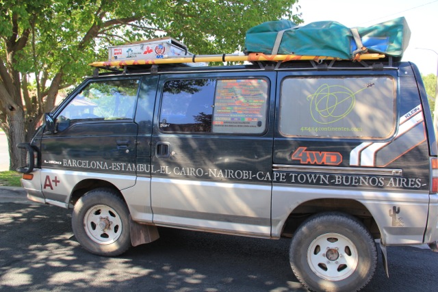
He has been travelling the globe for 12 yrs. (jealous) and has had a few articles on Expedition Portal, Overland Journal, etc. (very cool). And definitely a rad little van too. http://www.4x4x4continentes.com/
After picking up a few souvenirs in Moab, we headed south for Monticello. In Monticello we stopped for lunch at a little country/cowboy/hokey looking restaurant called MD Ranch Cookhouse.
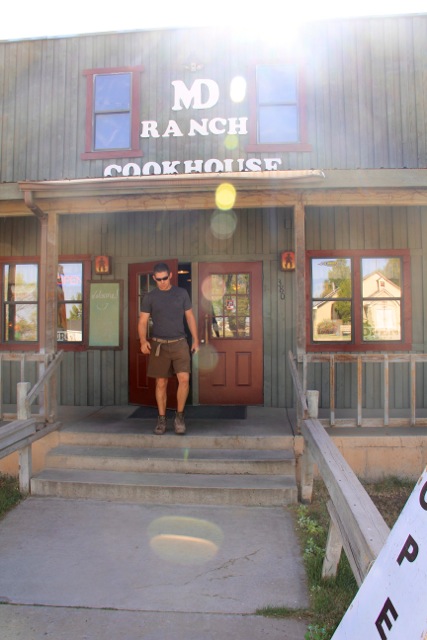
We both agreed that the food wasn’t going to be any good, but somehow we were very wrong. No one else was in the restaurant, but the food tasted great.

With stomachs satisfied we hopped onto Montezuma Canyon Road which is a nice scenic canyon drive. The cliff walls along the roadside are dotted with ancient Indian cliff dwellings (most of which are blocked off). The canyon was full of fertile land and small farms all the way along.
We made camp in the one pulloff we found along the way. It was a beautiful shady campsite, but we were inundated with flies. There was no water flowing, but any moisture in this area really brought the bugs. Not fun but hey, it was still pretty.


It is certainly an amazing thing to wake up into such beautiful surroundings.

The first order of the day was to go visit Arches National Park. We wanted to get there and get in a good hike before it got too hot (HA!). We chose to do the hike to Delicate Arch. For those that don’t know me, I am not the most social character to begin with, and having been by ourselves for so long was so nice. Being around crowds, and especially crowds of rude people was very weird at this point (and more annoying than usual).


The park itself was beautiful, but at this point we were spoiled and wanted to be back by ourselves again.

We headed back into Moab and stopped by Gearheadz again, filled up with water and met this guy (Pablo Rey) who was filling water containers too.

He has been travelling the globe for 12 yrs. (jealous) and has had a few articles on Expedition Portal, Overland Journal, etc. (very cool). And definitely a rad little van too. http://www.4x4x4continentes.com/
After picking up a few souvenirs in Moab, we headed south for Monticello. In Monticello we stopped for lunch at a little country/cowboy/hokey looking restaurant called MD Ranch Cookhouse.

We both agreed that the food wasn’t going to be any good, but somehow we were very wrong. No one else was in the restaurant, but the food tasted great.

With stomachs satisfied we hopped onto Montezuma Canyon Road which is a nice scenic canyon drive. The cliff walls along the roadside are dotted with ancient Indian cliff dwellings (most of which are blocked off). The canyon was full of fertile land and small farms all the way along.
We made camp in the one pulloff we found along the way. It was a beautiful shady campsite, but we were inundated with flies. There was no water flowing, but any moisture in this area really brought the bugs. Not fun but hey, it was still pretty.


Similar threads
- Replies
- 0
- Views
- 682
- Replies
- 2
- Views
- 549
- Replies
- 5
- Views
- 2K
